Bridge Statistics for Arlington, Massachusetts (MA)
Condition, Traffic, Stress, Structural Evaluation, Project Costs
- National Bridge Inventory (NBI) Statistics
- 15Number of bridges
- 82ft / 24.7mTotal length
- $25,950,000Total costs
- 479,271Total average daily traffic
- 25,917Total average daily truck traffic
- National Bridge Inventory (NBI) Registered Bridges for Arlington
- No street view available for this location
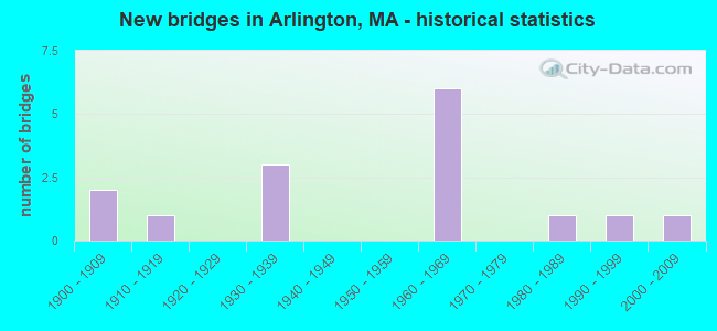
- New bridges - historical statistics
- 21900-1909
- 11910-1919
- 31930-1939
- 61960-1969
- 11980-1989
- 11990-1999
- 12000-2009

- Reconstructed bridges - Historical Statistics
- 21990-1999
- 12000-2009


- Bridge Condition - Deck
- 71.4%Good
- 14.3%Satisfactory
- 14.3%Fair

- Bridge Condition - Superstructure
- 45.5%Good
- 36.4%Satisfactory
- 18.2%Fair

- Bridge Condition - Substructure
- 27.3%Good
- 63.6%Satisfactory
- 9.1%Fair
Find on map >> Show street view
Structure Number: A100012MLDOT634, Location: 91.4 M NO OF MASS AVE (Lat: 42.425436, Lng: -71.182261), Route carried "on" structure: City street , Year Built: 1900, Year Reconstructed: 1998, Status: Open, Structure Length: 1.21m (3.97ft), Average Daily Traffic: 18,500 (year 2019), Truck Traffic: 2%, Average Future Daily Traffic: 13,677 (year 2032), Design Load: HS 20, Features Intersected: COMB MINUTMN BP & BROOK, Facility Carried by Structure: HWY PARK AVE
Minimum Vertical Clearance: 30+ m (98+ ft), Kilometerpoint: 0.000, Lanes on structure: 2, Owner: State Highway Agency, Approaching Roadway Width: 9.1m (29.9ft), Skew: 3 degrees, Material/Design: Prestressed concrete, Design/Construction: Box Beam or Girders - Multiple, Number Of Spans In Main Unit: 1, Length of Maximum Span: 10.6m (34.8ft), Curb or Sidewalk Widths: Left: 3.0m (9.8ft), Right: 0.0m, Curb-To-Curb Width: 9.1m (29.9ft), Out-to-Out Width: 13.0m (42.7ft)
Condition: Deck: Good, Superstructure: Good, Substructure: Satisfactory, Operating Rating: 72.8 metric tons, Method Used To Determine Operating Rating: Load Factor (LF), Inventory Rating: 43.6 metric tons, Method Used To Determine Inventory Rating: Load Factor (LF), Structural Evaluation: Equal to present minimum criteria, Deck Geometry: High priority of corrective action, Waterway Adequacy: Superior to present desirable criteria, Approach Roadway Alignment: Somewhat better than minimum adequacy, Length Of Structure Improvement: 1.30m (4.27ft), Designated Inspection Frequency: Every 24 months, Inspection Date: December 2021, Bridge Improvement Cost: $528,000, Roadway Improvement Cost: $53,000, Total Project Cost: $793,000 ( Estimate for 2022), Deck Structure Type: Concrete Precast Panels, Wearing Surface/Protective System: Wearing Surface: Bituminous, Membrane: Built-up, Deck Protection: Epoxy Coated Reinforcing
Find on map >> Show street view
Structure Number: A100042MMDOT634, Location: 200 FT SO PARK AVE (Lat: 42.425547, Lng: -71.180711), Route carried "on" structure: City street , Year Built: 1937, Year Reconstructed: 1997, Status: Open, Structure Length: 1.70m (5.58ft), Average Daily Traffic: 4,914 (year 2017), Truck Traffic: 3%, Average Future Daily Traffic: 8,370 (year 2032), Design Load: HS 20, Features Intersected: OTHER MINUTMN BP & BROOK, Facility Carried by Structure: HWY LOWELL ST
Minimum Vertical Clearance: 30+ m (98+ ft), Kilometerpoint: 0.000, Lanes on structure: 2, Owner: State Highway Agency, Approaching Roadway Width: 9.2m (30.2ft), Skew: 5 degrees, Material/Design: Prestressed concrete, Design/Construction: Slab, Number Of Spans In Main Unit: 1, Length of Maximum Span: 14.0m (45.9ft), Curb or Sidewalk Widths: Left: 0.0m, Right: 1.7m (5.6ft), Curb-To-Curb Width: 9.2m (30.2ft), Out-to-Out Width: 11.7m (38.4ft)
Condition: Deck: Good, Superstructure: Good, Substructure: Satisfactory, Operating Rating: 58.3 metric tons, Method Used To Determine Operating Rating: Allowable Stress (AS), Inventory Rating: 51.0 metric tons, Method Used To Determine Inventory Rating: Allowable Stress (AS), Structural Evaluation: Equal to present minimum criteria, Deck Geometry: Meets minimum limits, Approach Roadway Alignment: Equal to present minimum criteria, Length Of Structure Improvement: 1.80m (5.91ft), Designated Inspection Frequency: Every 24 months, Inspection Date: July 2021, Bridge Improvement Cost: $713,000, Roadway Improvement Cost: $72,000, Total Project Cost: $1,070,000 ( Estimate for 2022), Deck Structure Type: Concrete Precast Panels, Wearing Surface/Protective System: Wearing Surface: Bituminous, Membrane: Built-up
Find on map >> Show street view
Structure Number: A100084D3DOTNBI, Location: TOWN LINE MED ARL (Lat: 42.415544, Lng: -71.138394), Route carried "on" structure: City street , Year Built: 1938, Status: Open, Structure Length: 1.83m (6.00ft), Average Daily Traffic: 5,302 (year 2019), Truck Traffic: 5%, Average Future Daily Traffic: 4,738 (year 2032), Features Intersected: WATER MYSTIC RIVER, Facility Carried by Structure: HWY RIVER ST
Minimum Vertical Clearance: 30+ m (98+ ft), Kilometerpoint: 0.016, Lanes on structure: 2, Owner: State Highway Agency, Approaching Roadway Width: 11.3m (37.1ft), Material/Design: Concrete, Design/Construction: Arch - Deck, Number Of Spans In Main Unit: 1, Length of Maximum Span: 18.3m (60.0ft), Curb or Sidewalk Widths: Left: 2.4m (7.9ft), Right: 2.4m (7.9ft), Curb-To-Curb Width: 12.2m (40.0ft), Out-to-Out Width: 18.3m (60.0ft)
Condition: Superstructure: Satisfactory, Substructure: Satisfactory, Channel: Good, Structural Evaluation: Equal to present minimum criteria, Deck Geometry: Somewhat better than minimum adequacy, Waterway Adequacy: Better than present minimum criteria, Approach Roadway Alignment: Somewhat better than minimum adequacy, Length Of Structure Improvement: 1.90m (6.23ft), Designated Inspection Frequency: Every 24 months, Underwater Inspection Frequency: Every 36 months, Inspection Date: September 2021, Underwater Inspection Date: January 2022, Bridge Improvement Cost: $215,000, Roadway Improvement Cost: $22,000, Total Project Cost: $323,000 ( Estimate for 2022), Wearing Surface/Protective System: Wearing Surface: Bituminous
Find on map >> Show street view
Structure Number: A100094D2DOTNBI, Location: TOWN LINE MED ARL (Lat: 42.420569, Lng: -71.142881), Route carried "on" structure: State highway 60, Year Built: 1936, Status: Open, Structure Length: 1.52m (4.99ft), Average Daily Traffic: 24,310 (year 2019), Truck Traffic: 9%, Average Future Daily Traffic: 44,220 (year 2032), Features Intersected: WATER MYSTIC RIVER
Minimum Vertical Clearance: 30+ m (98+ ft), Kilometerpoint: 0.016, Lanes on structure: 4, Base Highway Network: Yes, Owner: State Highway Agency, Approaching Roadway Width: 10.7m (35.1ft), Material/Design: Concrete, Design/Construction: Arch - Deck, Number Of Spans In Main Unit: 1, Length of Maximum Span: 15.2m (49.9ft), Curb or Sidewalk Widths: Left: 2.5m (8.2ft), Right: 2.6m (8.5ft), Curb-To-Curb Width: 18.3m (60.0ft), Out-to-Out Width: 24.5m (80.4ft)
Condition: Superstructure: Satisfactory, Substructure: Good, Channel: Good, Structural Evaluation: Equal to present minimum criteria, Deck Geometry: Somewhat better than minimum adequacy, Waterway Adequacy: Equal to present minimum criteria, Approach Roadway Alignment: Somewhat better than minimum adequacy, Length Of Structure Improvement: 1.60m (5.25ft), Designated Inspection Frequency: Every 24 months, Underwater Inspection Frequency: Every 36 months, Inspection Date: September 2021, Underwater Inspection Date: October 2021, Bridge Improvement Cost: $574,000, Roadway Improvement Cost: $58,000, Total Project Cost: $862,000 ( Estimate for 2022), Wearing Surface/Protective System: Wearing Surface: Bituminous, Membrane: Preformed Fabric
Find on map >> Show street view
Structure Number: A10011AE2DOTNBI, Location: JUST W OLD ALEWIFE ROTARY (Lat: 42.398264, Lng: -71.143861), Route carried "on" structure: State highway 2, Year Built: 2004, Status: Open, Structure Length: 3.80m (12.47ft), Average Daily Traffic: 70,300 (year 2017), Truck Traffic: 10%, Average Future Daily Traffic: 120,027 (year 2032), Design Load: HS 20, Features Intersected: TR MNUTEMAN BP
Minimum Vertical Clearance: 30+ m (98+ ft), Kilometerpoint: 222.727, Lanes on structure: 4, Base Highway Network: Yes, Owner: State Highway Agency, Approaching Roadway Width: 26.4m (86.6ft), Skew: 34 degrees, Material/Design: Prestressed concrete, Design/Construction: Stringer/Multi-beam, Number Of Spans In Main Unit: 1, Length of Maximum Span: 35.9m (117.8ft), Curb or Sidewalk Widths: Left: 1.8m (5.9ft), Right: 1.8m (5.9ft), Curb-To-Curb Width: 20.5m (67.3ft), Out-to-Out Width: 26.4m (86.6ft)
Condition: Deck: Good, Superstructure: Good, Substructure: Good, Operating Rating: 79.2 metric tons, Method Used To Determine Operating Rating: Load Factor (LF), Inventory Rating: 47.4 metric tons, Method Used To Determine Inventory Rating: Load Factor (LF), Structural Evaluation: Better than present minimum criteria, Deck Geometry: Superior to present desirable criteria, Approach Roadway Alignment: Equal to present desirable criteria, Length Of Structure Improvement: 3.90m (12.80ft), Designated Inspection Frequency: Every 24 months, Inspection Date: January 2021, Bridge Improvement Cost: $578,000, Roadway Improvement Cost: $58,000, Total Project Cost: $868,000 ( Estimate for 2022), Deck Structure Type: Concrete Cast-file-Place, Wearing Surface/Protective System: Wearing Surface: Bituminous, Membrane: Built-up, Deck Protection: Epoxy Coated Reinforcing
Find on map >> Show street view
Structure Number: A100139WPDOTNBI, Location: 072288 128465599 (Lat: 42.404392, Lng: -71.134536), Route carried "on" structure: City street , Year Built: 1913, Status: Open, Structure Length: 0.91m (2.99ft), Average Daily Traffic: 650 (year 2017), Truck Traffic: 20%, Average Future Daily Traffic: 790 (year 2032), Features Intersected: WATER ALEWIFE BROOK, Facility Carried by Structure: HWY HENDERSON ST
Minimum Vertical Clearance: 30+ m (98+ ft), Kilometerpoint: 0.322, Lanes on structure: 1, Owner: State Highway Agency, Approaching Roadway Width: 5.6m (18.4ft), Material/Design: Concrete, Design/Construction: Arch - Deck, Number Of Spans In Main Unit: 1, Length of Maximum Span: 9.1m (29.9ft), Curb or Sidewalk Widths: Left: 1.6m (5.2ft), Right: 1.6m (5.2ft), Curb-To-Curb Width: 5.6m (18.4ft), Out-to-Out Width: 9.6m (31.5ft)
Condition: Superstructure: Satisfactory, Substructure: Satisfactory, Channel: Good, Operating Rating: 80.7 metric tons, Method Used To Determine Operating Rating: Load Factor (LF), Inventory Rating: 48.3 metric tons, Method Used To Determine Inventory Rating: Load Factor (LF), Structural Evaluation: Equal to present minimum criteria, Deck Geometry: High priority of replacement, Waterway Adequacy: Better than present minimum criteria, Approach Roadway Alignment: Meets minimum limits, Length Of Structure Improvement: 1.00m (3.28ft), Designated Inspection Frequency: Every 24 months, Inspection Date: November 2021, Bridge Improvement Cost: $623,000, Roadway Improvement Cost: $63,000, Total Project Cost: $935,000 ( Estimate for 2022), Wearing Surface/Protective System: Wearing Surface: Bituminous
Find on map >> Show street view
Structure Number: A100144D1DOTNBI, Location: .4 MI N OF BROADWAY (Lat: 42.414608, Lng: -71.132461), Route carried "on" structure: City street , Year Built: 1908, Year Reconstructed: 2013, Status: Open, Structure Length: 3.38m (11.09ft), Average Daily Traffic: 16,200 (year 2020), Truck Traffic: 5%, Average Future Daily Traffic: 32,849 (year 2032), Features Intersected: WATER ALEWIFE BROOK, Facility Carried by Structure: HWY MYST VAL PKY
Minimum Vertical Clearance: 30+ m (98+ ft), Kilometerpoint: 0.016, Lanes on structure: 2, Owner: State Highway Agency, Approaching Roadway Width: 12.4m (40.7ft), Material/Design: Concrete, Design/Construction: Arch - Deck, Number Of Spans In Main Unit: 1, Length of Maximum Span: 12.2m (40.0ft), Curb or Sidewalk Widths: Left: 3.6m (11.8ft), Right: 3.6m (11.8ft), Curb-To-Curb Width: 12.4m (40.7ft), Out-to-Out Width: 19.7m (64.6ft)
Condition: Superstructure: Satisfactory, Substructure: Good, Channel: Good, Inventory Rating: 67.8 metric tons, Method Used To Determine Inventory Rating: Load Factor (LF), Structural Evaluation: Equal to present minimum criteria, Deck Geometry: Somewhat better than minimum adequacy, Waterway Adequacy: Better than present minimum criteria, Approach Roadway Alignment: Better than present minimum criteria, Length Of Structure Improvement: 3.40m (11.15ft), Designated Inspection Frequency: Every 24 months, Underwater Inspection Frequency: Every 36 months, Inspection Date: June 2020, Underwater Inspection Date: March 2020, Bridge Improvement Cost: $321,000, Roadway Improvement Cost: $33,000, Total Project Cost: $482,000 ( Estimate for 2022)
Find on map >> Show street view
Structure Number: A100197XJMUNNBI, Location: 0.4 MI W OF PARK AVE (Lat: 42.425667, Lng: -71.189556), Route carried "on" structure: City street , Year Built: 1995, Status: Open, Structure Length: 0.79m (2.59ft), Average Daily Traffic: 400 (year 2017), Truck Traffic: 5%, Average Future Daily Traffic: 790 (year 2013), Design Load: HS 20, Features Intersected: OTHER MINUTEMAN BIKE PTH, Facility Carried by Structure: HWY DRAKE RD
Minimum Vertical Clearance: 30+ m (98+ ft), Kilometerpoint: 0.032, Lanes on structure: 2, Owner: Town or Township Highway Agency, Approaching Roadway Width: 6.7m (22.0ft), Material/Design: Prestressed concrete, Design/Construction: Slab, Number Of Spans In Main Unit: 1, Length of Maximum Span: 7.9m (25.9ft), Curb or Sidewalk Widths: Left: 1.7m (5.6ft), Right: 1.7m (5.6ft), Curb-To-Curb Width: 6.7m (22.0ft), Out-to-Out Width: 10.8m (35.4ft)
Condition: Deck: Good, Superstructure: Good, Substructure: Satisfactory, Inventory Rating: 77.6 metric tons, Method Used To Determine Inventory Rating: Load Factor (LF), Structural Evaluation: Equal to present minimum criteria, Deck Geometry: Meets minimum limits, Approach Roadway Alignment: Better than present minimum criteria, Length Of Structure Improvement: 0.80m (2.62ft), Designated Inspection Frequency: Every 24 months, Inspection Date: January 2021, Bridge Improvement Cost: $324,000, Roadway Improvement Cost: $33,000, Total Project Cost: $487,000 ( Estimate for 2022), Deck Structure Type: Concrete Precast Panels, Wearing Surface/Protective System: Wearing Surface: Bituminous
Find on map >> Show street view
Structure Number: A100212DMDOTNBI, Location: 0.5 MI E RT2 & RT60 (Lat: 42.402656, Lng: -71.156344), Route carried "on" structure: State highway 2, Year Built: 1967, Status: Posted for load, Structure Length: 5.27m (17.29ft), Average Daily Traffic: 78,000 (year 2016), Truck Traffic: 10%, Average Future Daily Traffic: 123,185 (year 2033), Design Load: H 20, Features Intersected: HWY LAKE ST
Minimum Vertical Clearance: 30+ m (98+ ft), Kilometerpoint: 216.195, Lanes on structure: 8, Lanes under structure: 4, Base Highway Network: Yes, Owner: State Highway Agency, Approaching Roadway Width: 40.8m (133.9ft), Skew: 24 degrees, Material/Design: Steel, Design/Construction: Stringer/Multi-beam, Number Of Spans In Main Unit: 3, Length of Maximum Span: 27.8m (91.2ft), Curb or Sidewalk Widths: Left: 0.5m (1.6ft), Right: 0.5m (1.6ft), Curb-To-Curb Width: 40.8m (133.9ft), Out-to-Out Width: 42.7m (140.1ft)
Condition: Deck: Satisfactory, Superstructure: Fair, Substructure: Satisfactory, Operating Rating: 41.3 metric tons, Method Used To Determine Operating Rating: Allowable Stress (AS), Inventory Rating: 21.2 metric tons, Method Used To Determine Inventory Rating: Allowable Stress (AS), Structural Evaluation: Somewhat better than minimum adequacy, Deck Geometry: Superior to present desirable criteria, Underclear: Meets minimum limits, Approach Roadway Alignment: Equal to present desirable criteria, Length Of Structure Improvement: 5.30m (17.39ft), Designated Inspection Frequency: Every 24 months, Inspection Date: Febuary 2022, Bridge Improvement Cost: $8,890,000, Roadway Improvement Cost: $890,000, Total Project Cost: $13,336,000 ( Estimate for 2022), Deck Structure Type: Concrete Cast-file-Place, Wearing Surface/Protective System: Wearing Surface: Bituminous
Find on map >> Show street view
Structure Number: A100232DPDOTNBI, Location: 0.75 MI W RT 2 & PARK AVE (Lat: 42.415381, Lng: -71.194267), Route carried "on" structure: State highway 2, Year Built: 1967, Status: Open, Structure Length: 2.62m (8.60ft), Average Daily Traffic: 67,100 (year 2018), Truck Traffic: 10%, Average Future Daily Traffic: 105,971 (year 2033), Design Load: H 20, Features Intersected: HWY DOW AVE
Minimum Vertical Clearance: 30+ m (98+ ft), Kilometerpoint: 218.060, Lanes on structure: 8, Lanes under structure: 2, Base Highway Network: Yes, Owner: State Highway Agency, Approaching Roadway Width: 40.8m (133.9ft), Skew: 20 degrees, Material/Design: Steel, Design/Construction: Stringer/Multi-beam, Number Of Spans In Main Unit: 1, Length of Maximum Span: 25.6m (84.0ft), Curb or Sidewalk Widths: Left: 0.5m (1.6ft), Right: 0.5m (1.6ft), Curb-To-Curb Width: 40.8m (133.9ft), Out-to-Out Width: 42.7m (140.1ft)
Condition: Deck: Fair, Superstructure: Good, Substructure: Fair, Operating Rating: 53.1 metric tons, Method Used To Determine Operating Rating: Load Factor (LF), Inventory Rating: 31.8 metric tons, Method Used To Determine Inventory Rating: Load Factor (LF), Structural Evaluation: Somewhat better than minimum adequacy, Deck Geometry: Superior to present desirable criteria, Underclear: Somewhat better than minimum adequacy, Approach Roadway Alignment: Equal to present desirable criteria, Length Of Structure Improvement: 2.70m (8.86ft), Designated Inspection Frequency: Every 24 months, Inspection Date: Febuary 2022, Bridge Improvement Cost: $4,529,000, Roadway Improvement Cost: $453,000, Total Project Cost: $6,794,000 ( Estimate for 2022), Deck Structure Type: Concrete Cast-file-Place, Wearing Surface/Protective System: Wearing Surface: Bituminous
Find on map >> Show street view
Structure Number: A100252DQDOTNBI, Location: 1.2 KM E RT 2 & LAKE ST (Lat: 42.397431, Lng: -71.143508), Route carried "on" structure: ServiceUS 2, Year Built: 1986, Year Reconstructed: 2021, Status: Open, Structure Length: 1.65m (5.41ft), Average Daily Traffic: 8,973 (year 2019), Truck Traffic: 5%, Average Future Daily Traffic: 29,375 (year 2032), Design Load: HS 20, Features Intersected: WATER ALEWIFE BROOK
Minimum Vertical Clearance: 30+ m (98+ ft), Kilometerpoint: 0.000, Lanes on structure: 1, Base Highway Network: Yes, Owner: State Highway Agency, Approaching Roadway Width: 6.7m (22.0ft), Material/Design: Prestressed concrete, Design/Construction: Slab, Number Of Spans In Main Unit: 1, Length of Maximum Span: 14.6m (47.9ft), Curb or Sidewalk Widths: Left: 2.3m (7.5ft), Right: 2.3m (7.5ft), Curb-To-Curb Width: 6.7m (22.0ft), Out-to-Out Width: 12.2m (40.0ft)
Condition: Deck: Good, Superstructure: Fair, Substructure: Satisfactory, Channel: Good, Operating Rating: 70.7 metric tons, Method Used To Determine Operating Rating: Load Factor (LF), Inventory Rating: 42.3 metric tons, Method Used To Determine Inventory Rating: Load Factor (LF), Structural Evaluation: Somewhat better than minimum adequacy, Deck Geometry: High priority of replacement, Waterway Adequacy: Equal to present desirable criteria, Approach Roadway Alignment: Better than present minimum criteria, Designated Inspection Frequency: Every 24 months, Underwater Inspection Frequency: Every 36 months, Inspection Date: September 2021, Underwater Inspection Date: June 2020, Deck Structure Type: Concrete Cast-file-Place, Wearing Surface/Protective System: Wearing Surface: Monolithic Concrete, Membrane: Built-up, Deck Protection: Epoxy Coated Reinforcing
Find on map >> Show street view
Structure Number: A100122DNDOTNBI, Location: RT 60 AT RT 2 (Lat: 42.416667, Lng: -71.166667), Route carried "under" structure: State highway 2, Year Built: 1967, Structure Length: 0. m, Average Daily Traffic: 53,811 (year 0000), Features Intersected: ST 2 WB, Facility Carried by Structure: ST 60
Minimum Vertical Clearance: 4.47m (14.67ft), Kilometerpoint: 212.138, Lanes on structure: 5, Lanes under structure: 6, Material/Design: Steel, Design/Construction: Stringer/Multi-beam, Length of Maximum Span: 29.0m (95.1ft)
Find on map >> Show street view
Structure Number: A100122DNDOTNBI, Location: RT 60 AT RT 2 (Lat: 42.416667, Lng: -71.166667), Route carried "under" structure: State highway 2, Year Built: 1967, Structure Length: 0. m, Average Daily Traffic: 53,811 (year 0000), Features Intersected: ST 2 EB, Facility Carried by Structure: ST 60
Minimum Vertical Clearance: 4.47m (14.67ft), Kilometerpoint: 0.000, Lanes on structure: 5, Lanes under structure: 6, Material/Design: Steel, Design/Construction: Stringer/Multi-beam, Length of Maximum Span: 29.0m (95.1ft)
Find on map >> Show street view
Structure Number: L100202KADOTNBI, Location: 0.75 MI E PLEASANT ST (Lat: 42.416667, Lng: -71.200000), Route carried "under" structure: State highway 2, Year Built: 1969, Structure Length: 0. m, Average Daily Traffic: 38,500 (year 0000), Features Intersected: ST 2 WB, Facility Carried by Structure: HWY WATERTOWN ST
Minimum Vertical Clearance: 4.42m (14.50ft), Kilometerpoint: 0.000, Lanes on structure: 2, Lanes under structure: 2, Material/Design: Steel, Design/Construction: Stringer/Multi-beam, Length of Maximum Span: 32.9m (107.9ft)
Find on map >> Show street view
Structure Number: L100202KADOTNBI, Location: 0.75 MI E PLEASANT ST (Lat: 42.416667, Lng: -71.200000), Route carried "under" structure: State highway 2, Year Built: 1969, Structure Length: 0. m, Average Daily Traffic: 38,500 (year 0000), Features Intersected: ST 2 EB, Facility Carried by Structure: HWY WATERTOWN ST
Minimum Vertical Clearance: 4.42m (14.50ft), Kilometerpoint: 0.000, Lanes on structure: 2, Lanes under structure: 2, Material/Design: Steel, Design/Construction: Stringer/Multi-beam, Length of Maximum Span: 32.9m (107.9ft)