Bridge Statistics for Canton, Massachusetts (MA)
Condition, Traffic, Stress, Structural Evaluation, Project Costs
- National Bridge Inventory (NBI) Statistics
- 30Number of bridges
- 358ft / 109mTotal length
- $92,614,000Total costs
- 1,194,933Total average daily traffic
- 89,003Total average daily truck traffic
- National Bridge Inventory (NBI) Registered Bridges for Canton
- No street view available for this location
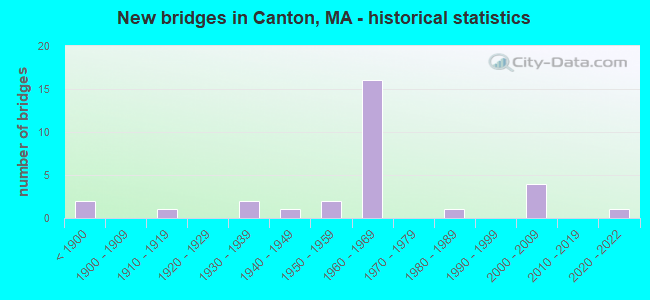
- New bridges - historical statistics
- 2Before 1900
- 11910-1919
- 21930-1939
- 11940-1949
- 21950-1959
- 161960-1969
- 11980-1989
- 42000-2009
- 12020-2022

- Reconstructed bridges - Historical Statistics
- 11920-1929
- 01930-1939
- 01940-1949
- 01950-1959
- 01960-1969
- 01970-1979
- 11980-1989
- 31990-1999


- Bridge Condition - Deck
- 4.8%Very good
- 61.9%Good
- 33.3%Satisfactory

- Bridge Condition - Superstructure
- 17.4%Very good
- 21.7%Good
- 34.8%Satisfactory
- 21.7%Fair
- 4.3%Poor

- Bridge Condition - Substructure
- 8.7%Very good
- 34.8%Good
- 30.4%Satisfactory
- 26.1%Fair

- Bridge Condition - Channel
- 16.7%Very good
- 50.0%Good
- 16.7%Satisfactory
- 16.7%Fair
Find on map >> Show street view
Structure Number: C0200136JDOTNBI, Location: .32 KM.NW OF I 95 (Lat: 42.209208, Lng: -71.145889), Route carried "on" structure: Other road , Year Built: 1931, Status: Open, Structure Length: 1.77m (5.81ft), Average Daily Traffic: 1,500 (year 2019), Average Future Daily Traffic: 1,263 (year 2032), Features Intersected: WATER NEPONSET RIVER, Facility Carried by Structure: HWY GREENLDGE ST
Minimum Vertical Clearance: 30+ m (98+ ft), Kilometerpoint: 0.000, Lanes on structure: 2, Owner: State Highway Agency, Approaching Roadway Width: 12.2m (40.0ft), Material/Design: Concrete, Design/Construction: Arch - Deck, Number Of Spans In Main Unit: 1, Length of Maximum Span: 17.7m (58.1ft), Curb or Sidewalk Widths: Left: 1.9m (6.2ft), Right: 0.0m, Curb-To-Curb Width: 12.3m (40.4ft), Out-to-Out Width: 15.3m (50.2ft)
Condition: Superstructure: Satisfactory, Substructure: Satisfactory, Channel: Satisfactory, Operating Rating: 78.0 metric tons, Method Used To Determine Operating Rating: Load Factor (LF), Inventory Rating: 25.8 metric tons, Method Used To Determine Inventory Rating: Load Factor (LF), Structural Evaluation: Equal to present minimum criteria, Deck Geometry: Better than present minimum criteria, Waterway Adequacy: Equal to present desirable criteria, Approach Roadway Alignment: Equal to present desirable criteria, Length Of Structure Improvement: 1.80m (5.91ft), Designated Inspection Frequency: Every 24 months, Underwater Inspection Frequency: Every 36 months, Inspection Date: July 2021, Underwater Inspection Date: March 2021, Bridge Improvement Cost: $1,082,000, Roadway Improvement Cost: $109,000, Total Project Cost: $1,624,000 ( Estimate for 2022), Wearing Surface/Protective System: Wearing Surface: Bituminous
Find on map >> Show street view
Structure Number: C02002ADAMUNNBI, Location: T/LWESTWOOD/NORWOOD (Lat: 42.196944, Lng: -71.154836), Route carried "on" structure: City street , Year Built: 2000, Status: Open, Structure Length: 3.09m (10.14ft), Average Daily Traffic: 22,000 (year 2019), Truck Traffic: 6%, Average Future Daily Traffic: 28,585 (year 2032), Design Load: HS 20, Features Intersected: WATER NEPONSET RIVER, Facility Carried by Structure: HWY DEDHAM ST
Minimum Vertical Clearance: 30+ m (98+ ft), Kilometerpoint: 0.016, Lanes on structure: 2, Owner: Town or Township Highway Agency, Approaching Roadway Width: 9.7m (31.8ft), Skew: 1 degrees, Material/Design: Steel, Design/Construction: Stringer/Multi-beam, Number Of Spans In Main Unit: 1, Length of Maximum Span: 29.3m (96.1ft), Curb-To-Curb Width: 9.7m (31.8ft), Out-to-Out Width: 10.9m (35.8ft)
Condition: Deck: Satisfactory, Superstructure: Good, Substructure: Good, Channel: Very good, Operating Rating: 68.0 metric tons, Method Used To Determine Operating Rating: Load Factor (LF), Inventory Rating: 40.8 metric tons, Method Used To Determine Inventory Rating: Load Factor (LF), Structural Evaluation: Better than present minimum criteria, Deck Geometry: High priority of corrective action, Waterway Adequacy: Better than present minimum criteria, Approach Roadway Alignment: Better than present minimum criteria, Length Of Structure Improvement: 3.10m (10.17ft), Designated Inspection Frequency: Every 24 months, Inspection Date: March 2021, Bridge Improvement Cost: $1,082,000, Roadway Improvement Cost: $109,000, Total Project Cost: $1,624,000 ( Estimate for 2022), Deck Structure Type: Concrete Cast-file-Place, Wearing Surface/Protective System: Wearing Surface: Latex Concrete, Deck Protection: Epoxy Coated Reinforcing
Find on map >> Show street view
Structure Number: C0200636YDOT634, Location: .16 KM.E OF CHAPMAN ST (Lat: 42.164981, Lng: -71.153936), Route carried "on" structure: City street , Year Built: 1888, Year Reconstructed: 2001, Status: Open, Structure Length: 2.18m (7.15ft), Average Daily Traffic: 7,000 (year 2019), Truck Traffic: 4%, Average Future Daily Traffic: 10,265 (year 2032), Design Load: HS 20, Features Intersected: RR AMTRAK/MBTA, Facility Carried by Structure: HWY SPAULDING ST
Minimum Vertical Clearance: 30+ m (98+ ft), Kilometerpoint: 0.000, Lanes on structure: 2, Owner: State Highway Agency, Approaching Roadway Width: 8.6m (28.2ft), Material/Design: Steel, Design/Construction: Stringer/Multi-beam, Number Of Spans In Main Unit: 1, Length of Maximum Span: 20.6m (67.6ft), Curb or Sidewalk Widths: Left: 1.5m (4.9ft), Right: 1.5m (4.9ft), Curb-To-Curb Width: 8.6m (28.2ft), Out-to-Out Width: 15.9m (52.2ft)
Condition: Deck: Good, Superstructure: Good, Substructure: Good, Operating Rating: 52.2 metric tons, Method Used To Determine Operating Rating: Load Factor (LF), Inventory Rating: 35.8 metric tons, Method Used To Determine Inventory Rating: Load Factor (LF), Structural Evaluation: Better than present minimum criteria, Deck Geometry: High priority of replacement, Underclear: High priority of replacement, Approach Roadway Alignment: High priority of corrective action, Length Of Structure Improvement: 3.00m (9.84ft), Designated Inspection Frequency: Every 24 months, Inspection Date: November 2021, Bridge Improvement Cost: $3,253,000, Roadway Improvement Cost: $326,000, Total Project Cost: $4,880,000 ( Estimate for 2022), Deck Structure Type: Concrete Cast-file-Place, Wearing Surface/Protective System: Wearing Surface: Monolithic Concrete, Membrane: Other, Deck Protection: Epoxy Coated Reinforcing
Find on map >> Show street view
Structure Number: C02008AE6DOT634, Location: .16 KM .E OF SHARON T. L (Lat: 42.148061, Lng: -71.160542), Route carried "on" structure: City street , Year Built: 2005, Status: Open, Structure Length: 20.31m (66.63ft), Average Daily Traffic: 4,000 (year 2019), Truck Traffic: 9%, Average Future Daily Traffic: 3,317 (year 2032), Design Load: HS 20, Features Intersected: RR AMTRAK/MBTA, Facility Carried by Structure: HWY HIGH ST
Minimum Vertical Clearance: 30+ m (98+ ft), Kilometerpoint: 0.000, Lanes on structure: 2, Owner: State Highway Agency, Approaching Roadway Width: 8.5m (27.9ft), Skew: 3 degrees, Material/Design: Steel continuous, Design/Construction: Stringer/Multi-beam, Number Of Spans In Main Unit: 3, Length of Maximum Span: 91.8m (301.2ft), Curb or Sidewalk Widths: Left: 1.5m (4.9ft), Right: 0.0m, Curb-To-Curb Width: 8.5m (27.9ft), Out-to-Out Width: 10.9m (35.8ft)
Condition: Deck: Good, Superstructure: Very good, Substructure: Good, Operating Rating: 66.6 metric tons, Method Used To Determine Operating Rating: Load Factor (LF), Inventory Rating: 39.9 metric tons, Method Used To Determine Inventory Rating: Load Factor (LF), Structural Evaluation: Better than present minimum criteria, Deck Geometry: Meets minimum limits, Underclear: High priority of corrective action, Approach Roadway Alignment: Equal to present desirable criteria, Length Of Structure Improvement: 20.40m (66.93ft), Designated Inspection Frequency: Every 24 months, Inspection Date: October 2021, Bridge Improvement Cost: $9,425,000, Roadway Improvement Cost: $943,000, Total Project Cost: $14,138,000 ( Estimate for 2022), Deck Structure Type: Concrete Cast-file-Place, Wearing Surface/Protective System: Wearing Surface: Bituminous, Membrane: Built-up, Deck Protection: Epoxy Coated Reinforcing
Find on map >> Show street view
Structure Number: C02009370DOT634, Location: .32 KM.NE OF NEPONSET ST (Lat: 42.166608, Lng: -71.154097), Route carried "on" structure: City street , Year Built: 1986, Status: Open, Structure Length: 3.75m (12.30ft), Average Daily Traffic: 15,000 (year 2019), Truck Traffic: 3%, Average Future Daily Traffic: 21,794 (year 2032), Design Load: H 20, Features Intersected: RR AMTRAK/MBTA, Facility Carried by Structure: HWY CHAPMAN ST
Minimum Vertical Clearance: 30+ m (98+ ft), Kilometerpoint: 0.483, Lanes on structure: 2, Owner: State Highway Agency, Approaching Roadway Width: 12.2m (40.0ft), Skew: 5 degrees, Material/Design: Steel, Design/Construction: Stringer/Multi-beam, Number Of Spans In Main Unit: 1, Length of Maximum Span: 35.2m (115.5ft), Curb or Sidewalk Widths: Left: 3.0m (9.8ft), Right: 1.5m (4.9ft), Curb-To-Curb Width: 12.2m (40.0ft), Out-to-Out Width: 17.6m (57.7ft)
Condition: Deck: Good, Superstructure: Good, Substructure: Good, Operating Rating: 71.0 metric tons, Method Used To Determine Operating Rating: Load Factor (LF), Inventory Rating: 42.6 metric tons, Method Used To Determine Inventory Rating: Load Factor (LF), Structural Evaluation: Better than present minimum criteria, Deck Geometry: Somewhat better than minimum adequacy, Underclear: Meets minimum limits, Approach Roadway Alignment: Equal to present desirable criteria, Length Of Structure Improvement: 3.80m (12.47ft), Designated Inspection Frequency: Every 24 months, Inspection Date: November 2021, Bridge Improvement Cost: $430,000, Roadway Improvement Cost: $44,000, Total Project Cost: $646,000 ( Estimate for 2022), Deck Structure Type: Concrete Cast-file-Place, Wearing Surface/Protective System: Wearing Surface: Bituminous, Membrane: Built-up, Deck Protection: Epoxy Coated Reinforcing
Find on map >> Show street view
Structure Number: C0201433FMUNNBI, Location: W. OF R.R. VIADUCT (Lat: 42.158697, Lng: -71.154642), Route carried "on" structure: City street , Year Built: 1850, Year Reconstructed: 1929, Status: Open, Structure Length: 0.61m (2.00ft), Average Daily Traffic: 23,000 (year 2018), Truck Traffic: 3%, Average Future Daily Traffic: 32,534 (year 2031), Features Intersected: WATER E BR NEPONSET RIV, Facility Carried by Structure: HWY NEPONSET ST
Minimum Vertical Clearance: 30+ m (98+ ft), Kilometerpoint: 0.998, Lanes on structure: 2, Base Highway Network: Yes, Owner: Town or Township Highway Agency, Approaching Roadway Width: 10.4m (34.1ft), Skew: 9 degrees, Material/Design: Masonry, Design/Construction: Arch - Deck, Number Of Spans In Main Unit: 1, Length of Maximum Span: 6.1m (20.0ft), Curb or Sidewalk Widths: Left: 1.5m (4.9ft), Right: 2.2m (7.2ft), Curb-To-Curb Width: 10.4m (34.1ft), Out-to-Out Width: 18.3m (60.0ft)
Condition: Superstructure: Satisfactory, Substructure: Fair, Channel: Fair, Structural Evaluation: Somewhat better than minimum adequacy, Deck Geometry: Meets minimum limits, Waterway Adequacy: Better than present minimum criteria, Approach Roadway Alignment: Equal to present minimum criteria, Length Of Structure Improvement: 0.70m (2.30ft), Designated Inspection Frequency: Every 24 months, Underwater Inspection Frequency: Every 24 months, Inspection Date: July 2020, Underwater Inspection Date: September 2020, Bridge Improvement Cost: $504,000, Roadway Improvement Cost: $51,000, Total Project Cost: $757,000 ( Estimate for 2022), Wearing Surface/Protective System: Wearing Surface: Bituminous
Find on map >> Show street view
Structure Number: C0201533GMUNNBI, Location: .16 KM S OF REVERE ST. (Lat: 42.154497, Lng: -71.145631), Route carried "on" structure: City street , Year Built: 1949, Status: Open, Structure Length: 1.04m (3.41ft), Average Daily Traffic: 21,200 (year 2018), Truck Traffic: 2%, Average Future Daily Traffic: 46,747 (year 2031), Design Load: H 20, Features Intersected: WATER E BR NEPONSET RIV, Facility Carried by Structure: HWY WASHNGTON ST
Minimum Vertical Clearance: 30+ m (98+ ft), Kilometerpoint: 1.931, Lanes on structure: 2, Base Highway Network: Yes, Owner: Town or Township Highway Agency, Approaching Roadway Width: 16.5m (54.1ft), Material/Design: Concrete, Design/Construction: Tee Beam, Number Of Spans In Main Unit: 1, Length of Maximum Span: 8.8m (28.9ft), Curb or Sidewalk Widths: Left: 4.0m (13.1ft), Right: 3.6m (11.8ft), Curb-To-Curb Width: 12.1m (39.7ft), Out-to-Out Width: 21.3m (69.9ft)
Condition: Deck: Satisfactory, Superstructure: Satisfactory, Substructure: Satisfactory, Channel: Fair, Operating Rating: 39.9 metric tons, Method Used To Determine Operating Rating: Load Factor (LF), Inventory Rating: 27.1 metric tons, Method Used To Determine Inventory Rating: Load Factor (LF), Structural Evaluation: Equal to present minimum criteria, Deck Geometry: Somewhat better than minimum adequacy, Waterway Adequacy: Equal to present desirable criteria, Approach Roadway Alignment: Equal to present desirable criteria, Length Of Structure Improvement: 1.10m (3.61ft), Designated Inspection Frequency: Every 24 months, Underwater Inspection Frequency: Every 24 months, Inspection Date: July 2020, Underwater Inspection Date: March 2021, Bridge Improvement Cost: $921,000, Roadway Improvement Cost: $93,000, Total Project Cost: $1,382,000 ( Estimate for 2022), Deck Structure Type: Concrete Cast-file-Place, Wearing Surface/Protective System: Wearing Surface: Bituminous
Find on map >> Show street view
Structure Number: C0202033UMUNNBI, Location: 3.5 KM S OF RT 95 (Lat: 42.146581, Lng: -71.147578), Route carried "on" structure: City street , Year Built: 1956, Status: Open, Structure Length: 0.84m (2.76ft), Average Daily Traffic: 260 (year 2020), Truck Traffic: 1%, Average Future Daily Traffic: 474 (year 2033), Design Load: H 15, Features Intersected: WATER MASSAPOAG BROOK, Facility Carried by Structure: HWY SHEPARD ST
Minimum Vertical Clearance: 30+ m (98+ ft), Kilometerpoint: 0.241, Lanes on structure: 1, Owner: Town or Township Highway Agency, Approaching Roadway Width: 5.2m (17.1ft), Material/Design: Prestressed concrete, Design/Construction: Slab, Number Of Spans In Main Unit: 1, Length of Maximum Span: 7.8m (25.6ft), Curb-To-Curb Width: 5.5m (18.0ft), Out-to-Out Width: 6.1m (20.0ft)
Condition: Deck: Good, Superstructure: Good, Substructure: Satisfactory, Channel: Good, Operating Rating: 97.0 metric tons, Method Used To Determine Operating Rating: Allowable Stress (AS), Inventory Rating: 50.6 metric tons, Method Used To Determine Inventory Rating: Allowable Stress (AS), Structural Evaluation: Equal to present minimum criteria, Deck Geometry: High priority of corrective action, Waterway Adequacy: Better than present minimum criteria, Approach Roadway Alignment: Equal to present minimum criteria, Length Of Structure Improvement: 1.60m (5.25ft), Designated Inspection Frequency: Every 24 months, Inspection Date: Febuary 2020, Bridge Improvement Cost: $973,000, Roadway Improvement Cost: $98,000, Total Project Cost: $1,460,000 ( Estimate for 2022), Deck Structure Type: Concrete Precast Panels, Wearing Surface/Protective System: Wearing Surface: Bituminous
Find on map >> Show street view
Structure Number: C02024371DOT634, Location: .16 KM. SE. NEPONSET R. (Lat: 42.196172, Lng: -71.153928), Route carried "on" structure: City street , Year Built: 1937, Year Reconstructed: 1995, Status: Open, Structure Length: 5.07m (16.63ft), Average Daily Traffic: 17,650 (year 2018), Truck Traffic: 6%, Average Future Daily Traffic: 24,953 (year 2032), Design Load: HS 20, Features Intersected: RR AMTRAK/MBTA, Facility Carried by Structure: HWY DEDHAM ST
Minimum Vertical Clearance: 30+ m (98+ ft), Kilometerpoint: 0.000, Lanes on structure: 2, Owner: State Highway Agency, Approaching Roadway Width: 9.8m (32.2ft), Skew: 2 degrees, Material/Design: Steel continuous, Design/Construction: Stringer/Multi-beam, Number Of Spans In Main Unit: 3, Length of Maximum Span: 21.7m (71.2ft), Curb-To-Curb Width: 9.8m (32.2ft), Out-to-Out Width: 11.0m (36.1ft)
Condition: Deck: Good, Superstructure: Good, Substructure: Good, Operating Rating: 82.5 metric tons, Method Used To Determine Operating Rating: Load Factor (LF), Inventory Rating: 49.4 metric tons, Method Used To Determine Inventory Rating: Load Factor (LF), Structural Evaluation: Better than present minimum criteria, Deck Geometry: Meets minimum limits, Underclear: High priority of corrective action, Approach Roadway Alignment: Better than present minimum criteria, Length Of Structure Improvement: 5.10m (16.73ft), Designated Inspection Frequency: Every 24 months, Inspection Date: November 2021, Bridge Improvement Cost: $1,732,000, Roadway Improvement Cost: $174,000, Total Project Cost: $2,599,000 ( Estimate for 2022), Deck Structure Type: Concrete Precast Panels, Wearing Surface/Protective System: Wearing Surface: Bituminous, Membrane: Built-up, Deck Protection: Epoxy Coated Reinforcing
Find on map >> Show street view
Structure Number: C020268FWDOTNBI, Location: I 95AT SOUTH END OF ST128 (Lat: 42.210158, Lng: -71.144492), Route carried "on" structure: Interstate 95, Year Built: 2008, Status: Open, Structure Length: 4.21m (13.81ft), Average Daily Traffic: 89,190 (year 2018), Truck Traffic: 10%, Average Future Daily Traffic: 266,270 (year 2032), Design Load: HS 25 or greater, Features Intersected: WATER NEPONSET RIVER
Minimum Vertical Clearance: 30+ m (98+ ft), Kilometerpoint: 0.000, Lanes on structure: 5, Owner: State Highway Agency, Approaching Roadway Width: 24.5m (80.4ft), Skew: 2 degrees, Material/Design: Steel, Design/Construction: Stringer/Multi-beam, Number Of Spans In Main Unit: 1, Length of Maximum Span: 39.9m (130.9ft), Curb-To-Curb Width: 24.7m (81.0ft), Out-to-Out Width: 25.8m (84.6ft)
Condition: Deck: Good, Superstructure: Very good, Substructure: Very good, Channel: Good, Operating Rating: 99.3 metric tons, Method Used To Determine Operating Rating: Load Factor (LF), Inventory Rating: 59.5 metric tons, Method Used To Determine Inventory Rating: Load Factor (LF), Structural Evaluation: Equal to present desirable criteria, Deck Geometry: Better than present minimum criteria, Waterway Adequacy: Equal to present desirable criteria, Approach Roadway Alignment: Equal to present desirable criteria, Length Of Structure Improvement: 4.30m (14.11ft), Designated Inspection Frequency: Every 24 months, Inspection Date: July 2021, Bridge Improvement Cost: $446,000, Roadway Improvement Cost: $45,000, Total Project Cost: $670,000 ( Estimate for 2022), Deck Structure Type: Concrete Cast-file-Place, Wearing Surface/Protective System: Wearing Surface: Bituminous, Membrane: Other, Deck Protection: Epoxy Coated Reinforcing
Find on map >> Show street view
Structure Number: C020278FTDOTNBI, Location: I 95AT SOUTH END OF ST128 (Lat: 42.209958, Lng: -71.144569), Route carried "on" structure: Interstate 95, Year Built: 2008, Status: Open, Structure Length: 4.21m (13.81ft), Average Daily Traffic: 87,092 (year 2018), Truck Traffic: 10%, Average Future Daily Traffic: 266,270 (year 2032), Design Load: HS 25 or greater, Features Intersected: WATER NEPONSET RIVER
Minimum Vertical Clearance: 30+ m (98+ ft), Kilometerpoint: 0.000, Lanes on structure: 5, Owner: State Highway Agency, Approaching Roadway Width: 24.5m (80.4ft), Skew: 2 degrees, Material/Design: Steel, Design/Construction: Stringer/Multi-beam, Number Of Spans In Main Unit: 1, Length of Maximum Span: 39.9m (130.9ft), Curb-To-Curb Width: 24.7m (81.0ft), Out-to-Out Width: 25.8m (84.6ft)
Condition: Deck: Good, Superstructure: Very good, Substructure: Good, Channel: Good, Operating Rating: 99.3 metric tons, Method Used To Determine Operating Rating: Load Factor (LF), Inventory Rating: 59.5 metric tons, Method Used To Determine Inventory Rating: Load Factor (LF), Structural Evaluation: Better than present minimum criteria, Deck Geometry: Better than present minimum criteria, Waterway Adequacy: Equal to present desirable criteria, Approach Roadway Alignment: Equal to present desirable criteria, Length Of Structure Improvement: 4.30m (14.11ft), Designated Inspection Frequency: Every 24 months, Inspection Date: July 2021, Bridge Improvement Cost: $446,000, Roadway Improvement Cost: $45,000, Total Project Cost: $670,000 ( Estimate for 2022), Deck Structure Type: Concrete Cast-file-Place, Wearing Surface/Protective System: Wearing Surface: Bituminous, Membrane: Other, Deck Protection: Epoxy Coated Reinforcing
Find on map >> Show street view
Structure Number: C0202836ADOTNBI, Location: ST 138 AT ST 128 (Lat: 42.203186, Lng: -71.119275), Route carried "on" structure: State highway 138, Year Built: 1955, Year Reconstructed: 1991, Status: Open, Structure Length: 5.12m (16.80ft), Average Daily Traffic: 77,200 (year 2019), Truck Traffic: 6%, Average Future Daily Traffic: 72,648 (year 2032), Design Load: HS 20, Features Intersected: I 93 /US1
Minimum Vertical Clearance: 30+ m (98+ ft), Kilometerpoint: 63.068, Lanes on structure: 4, Lanes under structure: 8, Base Highway Network: Yes, Owner: State Highway Agency, Approaching Roadway Width: 21.0m (68.9ft), Skew: 20 degrees, Material/Design: Steel continuous, Design/Construction: Stringer/Multi-beam, Number Of Spans In Main Unit: 2, Length of Maximum Span: 24.7m (81.0ft), Curb or Sidewalk Widths: Left: 1.5m (4.9ft), Right: 1.5m (4.9ft), Curb-To-Curb Width: 21.0m (68.9ft), Out-to-Out Width: 25.0m (82.0ft)
Condition: Deck: Good, Superstructure: Fair, Substructure: Satisfactory, Operating Rating: 45.9 metric tons, Method Used To Determine Operating Rating: Allowable Stress (AS), Inventory Rating: 35.1 metric tons, Method Used To Determine Inventory Rating: Allowable Stress (AS), Structural Evaluation: Somewhat better than minimum adequacy, Deck Geometry: Superior to present desirable criteria, Underclear: High priority of corrective action, Approach Roadway Alignment: Equal to present desirable criteria, Length Of Structure Improvement: 5.20m (17.06ft), Designated Inspection Frequency: Every 24 months, Inspection Date: September 2021, Bridge Improvement Cost: $5,107,000, Roadway Improvement Cost: $511,000, Total Project Cost: $7,661,000 ( Estimate for 2022), Deck Structure Type: Concrete Cast-file-Place, Wearing Surface/Protective System: Wearing Surface: Monolithic Concrete, Membrane: Built-up, Deck Protection: Epoxy Coated Reinforcing
Find on map >> Show street view
Structure Number: C0203135BDOTNBI, Location: .32 KM SW OF NEPONSET ST (Lat: 42.164817, Lng: -71.176539), Route carried "on" structure: Interstate 95, Year Built: 1963, Status: Open, Structure Length: 2.90m (9.51ft), Average Daily Traffic: 94,655 (year 2019), Truck Traffic: 8%, Average Future Daily Traffic: 178,461 (year 2032), Design Load: HS 20, Features Intersected: WATER NEPONSET RIVER
Minimum Vertical Clearance: 30+ m (98+ ft), Kilometerpoint: 0.000, Lanes on structure: 4, Base Highway Network: Yes, Owner: State Highway Agency, Approaching Roadway Width: 15.2m (49.9ft), Material/Design: Steel, Design/Construction: Stringer/Multi-beam, Number Of Spans In Main Unit: 1, Length of Maximum Span: 27.4m (89.9ft), Curb or Sidewalk Widths: Left: 0.5m (1.6ft), Right: 0.5m (1.6ft), Curb-To-Curb Width: 15.2m (49.9ft), Out-to-Out Width: 17.1m (56.1ft)
Condition: Deck: Good, Superstructure: Satisfactory, Substructure: Satisfactory, Channel: Good, Operating Rating: 60.5 metric tons, Method Used To Determine Operating Rating: Load Factor (LF), Inventory Rating: 36.3 metric tons, Method Used To Determine Inventory Rating: Load Factor (LF), Structural Evaluation: Equal to present minimum criteria, Deck Geometry: High priority of replacement, Waterway Adequacy: Equal to present desirable criteria, Approach Roadway Alignment: Equal to present desirable criteria, Length Of Structure Improvement: 3.00m (9.84ft), Designated Inspection Frequency: Every 24 months, Inspection Date: Febuary 2021, Bridge Improvement Cost: $1,952,000, Roadway Improvement Cost: $196,000, Total Project Cost: $2,929,000 ( Estimate for 2022), Deck Structure Type: Concrete Cast-file-Place, Wearing Surface/Protective System: Wearing Surface: Bituminous, Membrane: Built-up
Find on map >> Show street view
Structure Number: C0203135LDOTNBI, Location: .32 KM SW OF NEPONSET ST (Lat: 42.165042, Lng: -71.176969), Route carried "on" structure: Interstate 95, Year Built: 1963, Status: Open, Structure Length: 2.90m (9.51ft), Average Daily Traffic: 65,819 (year 2019), Truck Traffic: 10%, Average Future Daily Traffic: 178,461 (year 2032), Design Load: HS 20, Features Intersected: WATER NEPONSET RIVER
Minimum Vertical Clearance: 30+ m (98+ ft), Kilometerpoint: 0.000, Lanes on structure: 3, Base Highway Network: Yes, Owner: State Highway Agency, Approaching Roadway Width: 15.2m (49.9ft), Material/Design: Steel, Design/Construction: Stringer/Multi-beam, Number Of Spans In Main Unit: 1, Length of Maximum Span: 27.4m (89.9ft), Curb or Sidewalk Widths: Left: 0.5m (1.6ft), Right: 0.5m (1.6ft), Curb-To-Curb Width: 15.2m (49.9ft), Out-to-Out Width: 17.1m (56.1ft)
Condition: Deck: Good, Superstructure: Satisfactory, Substructure: Satisfactory, Channel: Good, Operating Rating: 56.3 metric tons, Method Used To Determine Operating Rating: Load Factor (LF), Inventory Rating: 33.7 metric tons, Method Used To Determine Inventory Rating: Load Factor (LF), Structural Evaluation: Equal to present minimum criteria, Deck Geometry: Meets minimum limits, Waterway Adequacy: Equal to present desirable criteria, Approach Roadway Alignment: Equal to present desirable criteria, Length Of Structure Improvement: 3.00m (9.84ft), Designated Inspection Frequency: Every 24 months, Inspection Date: Febuary 2021, Bridge Improvement Cost: $906,000, Roadway Improvement Cost: $91,000, Total Project Cost: $1,360,000 ( Estimate for 2022), Deck Structure Type: Concrete Cast-file-Place, Wearing Surface/Protective System: Wearing Surface: Bituminous, Membrane: Built-up
Find on map >> Show street view
Structure Number: C0203335CDOTNBI, Location: .32 KM SW OF DEDHAM ST (Lat: 42.187589, Lng: -71.155472), Route carried "on" structure: Interstate 95, Year Built: 1964, Status: Open, Structure Length: 2.44m (8.01ft), Average Daily Traffic: 98,275 (year 2019), Truck Traffic: 18%, Average Future Daily Traffic: 181,620 (year 2032), Design Load: HS 20, Features Intersected: RR AMTRAK/MBTA
Minimum Vertical Clearance: 30+ m (98+ ft), Kilometerpoint: 0.000, Lanes on structure: 3, Base Highway Network: Yes, Owner: State Highway Agency, Approaching Roadway Width: 15.2m (49.9ft), Skew: 3 degrees, Material/Design: Steel, Design/Construction: Stringer/Multi-beam, Number Of Spans In Main Unit: 1, Length of Maximum Span: 23.8m (78.1ft), Curb or Sidewalk Widths: Left: 0.5m (1.6ft), Right: 0.5m (1.6ft), Curb-To-Curb Width: 15.2m (49.9ft), Out-to-Out Width: 17.1m (56.1ft)
Condition: Deck: Good, Superstructure: Satisfactory, Substructure: Fair, Operating Rating: 58.4 metric tons, Method Used To Determine Operating Rating: Load Factor (LF), Inventory Rating: 35.0 metric tons, Method Used To Determine Inventory Rating: Load Factor (LF), Structural Evaluation: Somewhat better than minimum adequacy, Deck Geometry: Meets minimum limits, Underclear: Equal to present minimum criteria, Approach Roadway Alignment: Equal to present desirable criteria, Length Of Structure Improvement: 2.50m (8.20ft), Designated Inspection Frequency: Every 24 months, Inspection Date: August 2021, Bridge Improvement Cost: $1,680,000, Roadway Improvement Cost: $169,000, Total Project Cost: $2,521,000 ( Estimate for 2022), Deck Structure Type: Concrete Cast-file-Place, Wearing Surface/Protective System: Wearing Surface: Bituminous, Membrane: Built-up
Find on map >> Show street view
Structure Number: C0203335DDOTNBI, Location: .32 KM SW OF DEDHAM ST (Lat: 42.188206, Lng: -71.155533), Route carried "on" structure: Interstate 95, Year Built: 1964, Status: Open, Structure Length: 2.44m (8.01ft), Average Daily Traffic: 98,200 (year 2019), Truck Traffic: 18%, Average Future Daily Traffic: 181,620 (year 2032), Design Load: HS 20, Features Intersected: RR AMTRAK/MBTA
Minimum Vertical Clearance: 30+ m (98+ ft), Kilometerpoint: 0.000, Lanes on structure: 3, Base Highway Network: Yes, Owner: State Highway Agency, Approaching Roadway Width: 15.2m (49.9ft), Skew: 3 degrees, Material/Design: Steel, Design/Construction: Stringer/Multi-beam, Number Of Spans In Main Unit: 1, Length of Maximum Span: 23.8m (78.1ft), Curb or Sidewalk Widths: Left: 0.5m (1.6ft), Right: 0.5m (1.6ft), Curb-To-Curb Width: 15.2m (49.9ft), Out-to-Out Width: 17.1m (56.1ft)
Condition: Deck: Good, Superstructure: Satisfactory, Substructure: Fair, Operating Rating: 58.4 metric tons, Method Used To Determine Operating Rating: Load Factor (LF), Inventory Rating: 35.0 metric tons, Method Used To Determine Inventory Rating: Load Factor (LF), Structural Evaluation: Somewhat better than minimum adequacy, Deck Geometry: Meets minimum limits, Underclear: Equal to present minimum criteria, Approach Roadway Alignment: Equal to present desirable criteria, Length Of Structure Improvement: 2.50m (8.20ft), Designated Inspection Frequency: Every 24 months, Inspection Date: August 2021, Bridge Improvement Cost: $1,680,000, Roadway Improvement Cost: $169,000, Total Project Cost: $2,521,000 ( Estimate for 2022), Deck Structure Type: Concrete Cast-file-Place, Wearing Surface/Protective System: Wearing Surface: Bituminous, Membrane: Built-up
Find on map >> Show street view
Structure Number: C0203436HDOTNBI, Location: .2 MI.SE OF WESTWOOD T.L. (Lat: 42.192603, Lng: -71.151167), Route carried "on" structure: Other road , Year Built: 1964, Status: Open, Structure Length: 10.27m (33.69ft), Average Daily Traffic: 15,300 (year 2019), Truck Traffic: 7%, Average Future Daily Traffic: 33,955 (year 2032), Design Load: H 20, Features Intersected: I 95, Facility Carried by Structure: HWY DEDHAM ST
Minimum Vertical Clearance: 30+ m (98+ ft), Kilometerpoint: 0.000, Lanes on structure: 2, Lanes under structure: 8, Owner: State Highway Agency, Approaching Roadway Width: 9.8m (32.2ft), Skew: 2 degrees, Material/Design: Steel, Design/Construction: Stringer/Multi-beam, Number Of Spans In Main Unit: 5, Length of Maximum Span: 24.4m (80.1ft), Curb or Sidewalk Widths: Left: 0.4m (1.3ft), Right: 1.5m (4.9ft), Curb-To-Curb Width: 9.8m (32.2ft), Out-to-Out Width: 12.5m (41.0ft)
Condition: Deck: Satisfactory, Superstructure: Fair, Substructure: Good, Operating Rating: 47.3 metric tons, Method Used To Determine Operating Rating: Allowable Stress (AS), Inventory Rating: 23.9 metric tons, Method Used To Determine Inventory Rating: Allowable Stress (AS), Structural Evaluation: Somewhat better than minimum adequacy, Deck Geometry: Meets minimum limits, Underclear: High priority of corrective action, Approach Roadway Alignment: Equal to present desirable criteria, Length Of Structure Improvement: 10.30m (33.79ft), Designated Inspection Frequency: Every 24 months, Inspection Date: July 2021, Bridge Improvement Cost: $5,058,000, Roadway Improvement Cost: $506,000, Total Project Cost: $7,588,000 ( Estimate for 2022), Deck Structure Type: Concrete Cast-file-Place, Wearing Surface/Protective System: Wearing Surface: Bituminous, Membrane: Built-up
Find on map >> Show street view
Structure Number: C0203536MDOTNBI, Location: .16 KM SW OF ST128 (Lat: 42.204408, Lng: -71.141806), Route carried "on" structure: City street , Year Built: 1965, Status: Open, Structure Length: 11.40m (37.40ft), Average Daily Traffic: 100 (year 2019), Truck Traffic: 1%, Average Future Daily Traffic: 3,474 (year 2032), Design Load: HS 20, Features Intersected: I 95, Facility Carried by Structure: HWY GREENLDGE ST
Minimum Vertical Clearance: 30+ m (98+ ft), Kilometerpoint: 0.000, Lanes on structure: 2, Lanes under structure: 8, Owner: State Highway Agency, Approaching Roadway Width: 9.8m (32.2ft), Material/Design: Steel, Design/Construction: Stringer/Multi-beam, Number Of Spans In Main Unit: 6, Length of Maximum Span: 24.4m (80.1ft), Curb or Sidewalk Widths: Left: 1.5m (4.9ft), Right: 0.5m (1.6ft), Curb-To-Curb Width: 9.8m (32.2ft), Out-to-Out Width: 12.4m (40.7ft)
Condition: Deck: Satisfactory, Superstructure: Fair, Substructure: Good, Operating Rating: 48.1 metric tons, Method Used To Determine Operating Rating: Load Factor (LF), Inventory Rating: 28.8 metric tons, Method Used To Determine Inventory Rating: Load Factor (LF), Structural Evaluation: Somewhat better than minimum adequacy, Deck Geometry: Equal to present desirable criteria, Underclear: High priority of corrective action, Length Of Structure Improvement: 11.50m (37.73ft), Designated Inspection Frequency: Every 24 months, Inspection Date: March 2021, Bridge Improvement Cost: $5,602,000, Roadway Improvement Cost: $561,000, Total Project Cost: $8,404,000 ( Estimate for 2022), Deck Structure Type: Concrete Cast-file-Place, Wearing Surface/Protective System: Wearing Surface: Monolithic Concrete, Membrane: Built-up
Find on map >> Show street view
Structure Number: C0203635HDOTNBI, Location: I 95 AT ST 128 (Lat: 42.207581, Lng: -71.140000), Route carried "on" structure: Interstate 95, Year Built: 1966, Status: Open, Structure Length: 8.17m (26.80ft), Average Daily Traffic: 32,700 (year 2019), Truck Traffic: 13%, Average Future Daily Traffic: 173,723 (year 2032), Design Load: HS 20, Features Intersected: I 95 /US1/ST128
Minimum Vertical Clearance: 4.39m (14.40ft), Kilometerpoint: 0.000, Lanes on structure: 2, Lanes under structure: 10, Base Highway Network: Yes, Owner: State Highway Agency, Approaching Roadway Width: 28.0m (91.9ft), Skew: 21 degrees, Material/Design: Steel, Design/Construction: Stringer/Multi-beam, Number Of Spans In Main Unit: 4, Length of Maximum Span: 23.5m (77.1ft), Curb or Sidewalk Widths: Left: 0.5m (1.6ft), Right: 0.2m (0.7ft), Curb-To-Curb Width: 28.0m (91.9ft), Out-to-Out Width: 29.8m (97.8ft)
Condition: Deck: Satisfactory, Superstructure: Fair, Substructure: Fair, Operating Rating: 37.4 metric tons, Method Used To Determine Operating Rating: Load Factor (LF), Inventory Rating: 33.3 metric tons, Method Used To Determine Inventory Rating: Load Factor (LF), Structural Evaluation: Somewhat better than minimum adequacy, Deck Geometry: Superior to present desirable criteria, Underclear: High priority of corrective action, Approach Roadway Alignment: Better than present minimum criteria, Length Of Structure Improvement: 8.20m (26.90ft), Designated Inspection Frequency: Every 24 months, Inspection Date: Febuary 2021, Bridge Improvement Cost: $9,599,000, Roadway Improvement Cost: $960,000, Total Project Cost: $14,399,000 ( Estimate for 2022), Deck Structure Type: Concrete Cast-file-Place, Wearing Surface/Protective System: Wearing Surface: Bituminous, Membrane: Built-up
Find on map >> Show street view
Structure Number: C0203635JDOTNBI, Location: I 95 AT ST 128 (Lat: 42.207861, Lng: -71.140425), Route carried "on" structure: Interstate 95, Year Built: 1966, Status: Open, Structure Length: 8.17m (26.80ft), Average Daily Traffic: 40,100 (year 2019), Truck Traffic: 9%, Average Future Daily Traffic: 173,723 (year 2032), Design Load: HS 20, Features Intersected: I 95 /US1/ST128
Minimum Vertical Clearance: 30+ m (98+ ft), Kilometerpoint: 0.000, Lanes on structure: 2, Lanes under structure: 10, Base Highway Network: Yes, Owner: State Highway Agency, Approaching Roadway Width: 15.8m (51.8ft), Skew: 1 degrees, Material/Design: Steel, Design/Construction: Stringer/Multi-beam, Number Of Spans In Main Unit: 4, Length of Maximum Span: 23.5m (77.1ft), Curb or Sidewalk Widths: Left: 0.5m (1.6ft), Right: 0.5m (1.6ft), Curb-To-Curb Width: 15.8m (51.8ft), Out-to-Out Width: 17.7m (58.1ft)
Condition: Deck: Satisfactory, Superstructure: Satisfactory, Substructure: Fair, Operating Rating: 53.3 metric tons, Method Used To Determine Operating Rating: Load Factor (LF), Inventory Rating: 32.0 metric tons, Method Used To Determine Inventory Rating: Load Factor (LF), Structural Evaluation: Somewhat better than minimum adequacy, Deck Geometry: Superior to present desirable criteria, Underclear: High priority of corrective action, Approach Roadway Alignment: Equal to present desirable criteria, Length Of Structure Improvement: 8.20m (26.90ft), Designated Inspection Frequency: Every 24 months, Inspection Date: Febuary 2021, Bridge Improvement Cost: $5,702,000, Roadway Improvement Cost: $571,000, Total Project Cost: $8,554,000 ( Estimate for 2022), Deck Structure Type: Concrete Cast-file-Place, Wearing Surface/Protective System: Wearing Surface: Bituminous, Membrane: Built-up
Find on map >> Show street view
Structure Number: C02037368DOTNBI, Location: .16 KM SE OF I 95 (Lat: 42.168700, Lng: -71.167775), Route carried "on" structure: City street , Year Built: 1963, Year Reconstructed: 1995, Status: Open, Structure Length: 3.51m (11.52ft), Average Daily Traffic: 37,000 (year 2022), Truck Traffic: 10%, Average Future Daily Traffic: 50,380 (year 2033), Design Load: HS 20, Features Intersected: WATER NEPONSET RIVER, Facility Carried by Structure: HWY NEPONSET ST
Minimum Vertical Clearance: 30+ m (98+ ft), Kilometerpoint: 0.000, Lanes on structure: 3, Base Highway Network: Yes, Owner: State Highway Agency, Approaching Roadway Width: 21.3m (69.9ft), Material/Design: Steel continuous, Design/Construction: Stringer/Multi-beam, Number Of Spans In Main Unit: 3, Length of Maximum Span: 17.1m (56.1ft), Curb or Sidewalk Widths: Left: 0.5m (1.6ft), Right: 1.5m (4.9ft), Curb-To-Curb Width: 17.8m (58.4ft), Out-to-Out Width: 19.7m (64.6ft)
Condition: Deck: Good, Superstructure: Fair, Substructure: Satisfactory, Channel: Good, Operating Rating: 62.1 metric tons, Method Used To Determine Operating Rating: Allowable Stress (AS), Inventory Rating: 35.1 metric tons, Method Used To Determine Inventory Rating: Allowable Stress (AS), Structural Evaluation: Somewhat better than minimum adequacy, Deck Geometry: Superior to present desirable criteria, Waterway Adequacy: Equal to present desirable criteria, Approach Roadway Alignment: Equal to present desirable criteria, Length Of Structure Improvement: 3.60m (11.81ft), Designated Inspection Frequency: Every 24 months, Underwater Inspection Frequency: Every 36 months, Inspection Date: January 2022, Underwater Inspection Date: August 2021, Bridge Improvement Cost: $2,786,000, Roadway Improvement Cost: $279,000, Total Project Cost: $4,180,000 ( Estimate for 2022), Deck Structure Type: Concrete Cast-file-Place, Wearing Surface/Protective System: Wearing Surface: Bituminous, Membrane: Built-up, Deck Protection: Epoxy Coated Reinforcing
Find on map >> Show street view
Structure Number: C0204233VMUNNBI, Location: 2.4 KM SE OF RTE. 95 (Lat: 42.154472, Lng: -71.147083), Route carried "on" structure: City street , Year Built: 1910, Status: Open, Structure Length: 1.13m (3.71ft), Average Daily Traffic: 800 (year 2020), Truck Traffic: 1%, Average Future Daily Traffic: 790 (year 2031), Features Intersected: WATER E BR NEPONSET RIV, Facility Carried by Structure: HWY REVERE CT
Minimum Vertical Clearance: 30+ m (98+ ft), Kilometerpoint: 0.064, Lanes on structure: 1, Owner: Town or Township Highway Agency, Approaching Roadway Width: 4.3m (14.1ft), Material/Design: Steel, Design/Construction: Stringer/Multi-beam, Number Of Spans In Main Unit: 1, Length of Maximum Span: 10.4m (34.1ft), Curb-To-Curb Width: 3.3m (10.8ft), Out-to-Out Width: 4.8m (15.7ft)
Condition: Deck: Satisfactory, Superstructure: Poor, Substructure: Fair, Channel: Satisfactory, Operating Rating: 33.4 metric tons, Method Used To Determine Operating Rating: Allowable Stress (AS), Inventory Rating: 22.1 metric tons, Method Used To Determine Inventory Rating: Allowable Stress (AS), Structural Evaluation: Meets minimum limits, Deck Geometry: High priority of replacement, Waterway Adequacy: Equal to present minimum criteria, Approach Roadway Alignment: Meets minimum limits, Length Of Structure Improvement: 1.90m (6.23ft), Designated Inspection Frequency: Every 12 months, Other Special Inspection Frequency: Every 12 months, Inspection Date: March 2020, Other Special Inspection Date: March 2021, Bridge Improvement Cost: $1,364,000, Roadway Improvement Cost: $137,000, Total Project Cost: $2,047,000 ( Estimate for 2022), Deck Structure Type: Wood or Timber, Wearing Surface/Protective System: Wearing Surface: Bituminous
Find on map >> Show street view
Structure Number: C02051BYQMUNNBI, Location: AT/NEAR NEPONSET STREET (Lat: 42.154719, Lng: -71.152522), Route carried "on" structure: City street , Year Built: 2020, Status: Open, Structure Length: 3.06m (10.04ft), Design Load: HL 93, Features Intersected: WATER EB NEPONSET RIVER, Facility Carried by Structure: HWY REVOLUTION W
Minimum Vertical Clearance: 30+ m (98+ ft), Kilometerpoint: 0.000, Lanes on structure: 2, Owner: City or Municipal Highway Agency, Approaching Roadway Width: 9.1m (29.9ft), Material/Design: Steel, Design/Construction: Truss - Deck, Number Of Spans In Main Unit: 1, Length of Maximum Span: 30.6m (100.4ft), Curb or Sidewalk Widths: Left: 1.7m (5.6ft), Right: 0.0m, Curb-To-Curb Width: 9.1m (29.9ft), Out-to-Out Width: 11.4m (37.4ft)
Condition: Deck: Very good, Superstructure: Very good, Substructure: Very good, Channel: Very good, Operating Rating: 42.1 metric tons, Method Used To Determine Operating Rating: Assigned ratings based on Load and Resistance Factor Design (LRFD) reported by rating factor (RF) using HL93 loadings, Inventory Rating: 32.4 metric tons, Method Used To Determine Inventory Rating: Assigned ratings based on Load and Resistance Factor Design (LRFD) reported by rating factor (RF) using HL93 loadings, Structural Evaluation: Equal to present desirable criteria, Deck Geometry: Better than present minimum criteria, Waterway Adequacy: Superior to present desirable criteria, Approach Roadway Alignment: Equal to present desirable criteria, Designated Inspection Frequency: Every 24 months, Inspection Date: October 2020, Deck Structure Type: Concrete Cast-file-Place, Wearing Surface/Protective System: Wearing Surface: Monolithic Concrete
Find on map >> Show street view
Structure Number: C0203436HDOTNBI, Location: .2 MI.SE OF WESTWOOD T.L. (Lat: 42.200000, Lng: -71.150000), Route carried "under" structure: Interstate 95, Year Built: 1964, Structure Length: 0. m, Average Daily Traffic: 59,750 (year 0000), Features Intersected: I 95 SB, Facility Carried by Structure: HWY DEDHAM ST
Minimum Vertical Clearance: 5.03m (16.50ft), Kilometerpoint: 0.000, Lanes on structure: 4, Lanes under structure: 2, Material/Design: Steel, Design/Construction: Stringer/Multi-beam, Length of Maximum Span: 24.4m (80.1ft)
Find on map >> Show street view
Structure Number: C0203436HDOTNBI, Location: .2 MI.SE OF WESTWOOD T.L. (Lat: 42.200000, Lng: -71.150000), Route carried "under" structure: Interstate 95, Year Built: 1964, Structure Length: 0. m, Average Daily Traffic: 59,750 (year 0000), Features Intersected: I 95 NB, Facility Carried by Structure: HWY DEDHAM ST
Minimum Vertical Clearance: 5.03m (16.50ft), Kilometerpoint: 0.000, Lanes on structure: 4, Lanes under structure: 2, Material/Design: Steel, Design/Construction: Stringer/Multi-beam, Length of Maximum Span: 24.4m (80.1ft)
Find on map >> Show street view
Structure Number: C0203536MDOTNBI, Location: 000065 STATUTORY (Lat: 42.200000, Lng: -71.150000), Route carried "under" structure: Interstate 95, Year Built: 1965, Structure Length: 0. m, Average Daily Traffic: 59,750 (year 0000), Features Intersected: I 95 SB, Facility Carried by Structure: HWY GRNLDGE ST
Minimum Vertical Clearance: 5.08m (16.67ft), Kilometerpoint: 0.000, Lanes on structure: 11, Lanes under structure: 2, Material/Design: Steel, Design/Construction: Stringer/Multi-beam, Length of Maximum Span: 23.2m (76.1ft)
Find on map >> Show street view
Structure Number: C0203536MDOTNBI, Location: .1 MI.SW OF ST 128 (Lat: 42.200000, Lng: -71.150000), Route carried "under" structure: Interstate 95, Year Built: 1965, Structure Length: 0. m, Average Daily Traffic: 59,750 (year 0000), Features Intersected: I 95 NB, Facility Carried by Structure: HWY GRNLDGE ST
Minimum Vertical Clearance: 5.08m (16.67ft), Kilometerpoint: 0.000, Lanes on structure: 2, Lanes under structure: 8, Material/Design: Steel, Design/Construction: Stringer/Multi-beam, Length of Maximum Span: 23.2m (76.1ft)
Find on map >> Show street view
Structure Number: C0203635HDOTNBI, Location: I 95 AT ST 128 (Lat: 42.216667, Lng: -71.150000), Route carried "under" structure: Interstate 95, Year Built: 1966, Structure Length: 0. m, Average Daily Traffic: 35,964 (year 0000), Features Intersected: I 95 SB
Minimum Vertical Clearance: 4.44m (14.57ft), Kilometerpoint: 0.000, Lanes on structure: 6, Lanes under structure: 4, Material/Design: Steel, Design/Construction: Stringer/Multi-beam, Length of Maximum Span: 23.5m (77.1ft)
Find on map >> Show street view
Structure Number: C0203635JDOTNBI, Location: I 95 AT ST 128 (Lat: 42.200000, Lng: -71.133333), Route carried "under" structure: Interstate 95, Year Built: 1966, Structure Length: 0. m, Average Daily Traffic: 35,964 (year 0000), Features Intersected: I 95 NB
Minimum Vertical Clearance: 30+ m (98+ ft), Kilometerpoint: 0.000, Lanes on structure: 4, Lanes under structure: 3, Material/Design: Steel, Design/Construction: Stringer/Multi-beam, Length of Maximum Span: 23.5m (77.1ft)
Find on map >> Show street view
Structure Number: C0203635JDOTNBI, Location: I 95 AT ST 128 (Lat: 42.216667, Lng: -71.150000), Route carried "under" structure: Interstate 95, Year Built: 1966, Structure Length: 0. m, Average Daily Traffic: 35,964 (year 0000), Features Intersected: I 95 SB
Minimum Vertical Clearance: 4.47m (14.67ft), Kilometerpoint: 0.000, Lanes on structure: 4, Lanes under structure: 3, Material/Design: Steel, Design/Construction: Stringer/Multi-beam, Length of Maximum Span: 23.5m (77.1ft)