Bridge Statistics for East Bridgewater, Massachusetts (MA)
Condition, Traffic, Stress, Structural Evaluation, Project Costs
- National Bridge Inventory (NBI) Statistics
- 11Number of bridges
- 46ft / 14.1mTotal length
- $14,379,000Total costs
- 100,446Total average daily traffic
- 5,899Total average daily truck traffic
- 210,916Total future (year 2031) average daily traffic
- National Bridge Inventory (NBI) Registered Bridges for East Bridgewater
- No street view available for this location
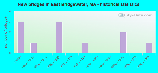
- New bridges - historical statistics
- 3Before 1900
- 11900-1909
- 31920-1929
- 11940-1949
- 21970-1979
- 11990-1999

- Reconstructed bridges - Historical Statistics
- 11920-1929
- 11930-1939
- 11940-1949


- Bridge Condition - Deck
- 16.7%Very good
- 33.3%Good
- 16.7%Satisfactory
- 33.3%Fair

- Bridge Condition - Superstructure
- 12.5%Very good
- 25.0%Good
- 12.5%Satisfactory
- 50.0%Fair

- Bridge Condition - Substructure
- 12.5%Very good
- 62.5%Good
- 25.0%Satisfactory

- Bridge Condition - Channel
- 40.0%Good
- 30.0%Satisfactory
- 30.0%Fair

- Bridge Condition - Culverts
- 33.3%Good
- 33.3%Satisfactory
- 33.3%Fair
Find on map >> Show street view
Structure Number: E0100141QMUNNBI, Location: .55 MI SW RTE 18 (Lat: 42.026461, Lng: -70.967233), Route carried "on" structure: City street , Year Built: 1946, Status: Posted for load, Structure Length: 1.89m (6.20ft), Average Daily Traffic: 8,922 (year 2018), Truck Traffic: 16%, Average Future Daily Traffic: 15,793 (year 2031), Design Load: H 15, Features Intersected: WATER MATFIELD RIVER, Facility Carried by Structure: HWY SPRING ST
Minimum Vertical Clearance: 30+ m (98+ ft), Kilometerpoint: 1.062, Lanes on structure: 2, Owner: Town or Township Highway Agency, Approaching Roadway Width: 7.6m (24.9ft), Material/Design: Concrete continuous, Design/Construction: Slab, Number Of Spans In Main Unit: 3, Length of Maximum Span: 6.1m (20.0ft), Curb or Sidewalk Widths: Left: 0.3m (1.0ft), Right: 1.5m (4.9ft), Curb-To-Curb Width: 9.1m (29.9ft), Out-to-Out Width: 11.9m (39.0ft)
Condition: Deck: Good, Superstructure: Good, Substructure: Good, Channel: Fair, Operating Rating: 37.6 metric tons, Method Used To Determine Operating Rating: Allowable Stress (AS), Inventory Rating: 22.9 metric tons, Method Used To Determine Inventory Rating: Allowable Stress (AS), Structural Evaluation: Somewhat better than minimum adequacy, Deck Geometry: High priority of corrective action, Waterway Adequacy: Equal to present minimum criteria, Approach Roadway Alignment: Better than present minimum criteria, Length Of Structure Improvement: 1.90m (6.23ft), Designated Inspection Frequency: Every 24 months, Underwater Inspection Frequency: Every 24 months, Inspection Date: October 2020, Underwater Inspection Date: Febuary 2021, Bridge Improvement Cost: $889,000, Roadway Improvement Cost: $89,000, Total Project Cost: $1,334,000 ( Estimate for 2022), Deck Structure Type: Concrete Cast-file-Place, Wearing Surface/Protective System: Wearing Surface: Bituminous
Find on map >> Show street view
Structure Number: E0100247UDOTNBI, Location: 0.1 M S OF RTE 106 (Lat: 42.015494, Lng: -70.961158), Route carried "on" structure: State highway 18, Year Built: 1880, Year Reconstructed: 1930, Status: Open, Structure Length: 0.79m (2.59ft), Average Daily Traffic: 23,189 (year 2019), Truck Traffic: 6%, Average Future Daily Traffic: 58,434 (year 2031), Features Intersected: WATER MATFIELD RIVER
Minimum Vertical Clearance: 30+ m (98+ ft), Kilometerpoint: 45.076, Lanes on structure: 4, Base Highway Network: Yes, Owner: State Highway Agency, Approaching Roadway Width: 12.2m (40.0ft), Material/Design: Masonry, Design/Construction: Arch - Deck, Number Of Spans In Main Unit: 1, Length of Maximum Span: 7.9m (25.9ft), Curb or Sidewalk Widths: Left: 2.0m (6.6ft), Right: 2.0m (6.6ft), Curb-To-Curb Width: 15.2m (49.9ft), Out-to-Out Width: 20.2m (66.3ft)
Condition: Superstructure: Good, Substructure: Good, Channel: Satisfactory, Operating Rating: 91.6 metric tons, Method Used To Determine Operating Rating: Load Factor (LF), Inventory Rating: 54.9 metric tons, Method Used To Determine Inventory Rating: Load Factor (LF), Structural Evaluation: Better than present minimum criteria, Deck Geometry: High priority of corrective action, Waterway Adequacy: Equal to present desirable criteria, Approach Roadway Alignment: Equal to present desirable criteria, Length Of Structure Improvement: 0.80m (2.62ft), Designated Inspection Frequency: Every 24 months, Inspection Date: September 2020, Bridge Improvement Cost: $521,000, Roadway Improvement Cost: $53,000, Total Project Cost: $782,000 ( Estimate for 2022)
Find on map >> Show street view
Structure Number: E0100347VDOTNBI, Location: .25 MI N OF CENTRAL ST (Lat: 42.035683, Lng: -70.958122), Route carried "on" structure: State highway 18, Year Built: 1893, Year Reconstructed: 1940, Status: Posted for load, Structure Length: 2.23m (7.32ft), Average Daily Traffic: 17,237 (year 2019), Truck Traffic: 3%, Average Future Daily Traffic: 47,853 (year 2032), Design Load: H 20, Features Intersected: WATER FORGE POND
Minimum Vertical Clearance: 30+ m (98+ ft), Kilometerpoint: 48.054, Lanes on structure: 2, Base Highway Network: Yes, Owner: State Highway Agency, Approaching Roadway Width: 14.0m (45.9ft), Material/Design: Masonry, Design/Construction: Arch - Deck, Number Of Spans In Main Unit: 1, Length of Maximum Span: 9.1m (29.9ft), Curb or Sidewalk Widths: Left: 1.8m (5.9ft), Right: 1.8m (5.9ft), Curb-To-Curb Width: 14.0m (45.9ft), Out-to-Out Width: 18.7m (61.4ft)
Condition: Deck: Fair, Superstructure: Fair, Substructure: Good, Channel: Good, Operating Rating: 22.0 metric tons, Method Used To Determine Operating Rating: Load Factor (LF), Inventory Rating: 18.6 metric tons, Method Used To Determine Inventory Rating: Load Factor (LF), Structural Evaluation: Meets minimum limits, Deck Geometry: Superior to present desirable criteria, Waterway Adequacy: Equal to present desirable criteria, Approach Roadway Alignment: Equal to present desirable criteria, Bridge Posting: Required (Relationship of Operating Rating to Maximum Legal Load: 30.0 - 39.9% below), Length Of Structure Improvement: 2.30m (7.55ft), Designated Inspection Frequency: Every 24 months, Underwater Inspection Frequency: Every 36 months, Inspection Date: August 2021, Underwater Inspection Date: April 2019, Bridge Improvement Cost: $1,690,000, Roadway Improvement Cost: $170,000, Total Project Cost: $2,536,000 ( Estimate for 2022)
Find on map >> Show street view
Structure Number: E0100641PMUNNBI, Location: .6 MI SW RTE 18 (Lat: 42.031158, Lng: -70.970703), Route carried "on" structure: City street , Year Built: 1902, Status: Open, Structure Length: 0.85m (2.79ft), Average Daily Traffic: 4,098 (year 2018), Truck Traffic: 5%, Average Future Daily Traffic: 6,554 (year 2031), Features Intersected: WATER MATFIELD RIVER, Facility Carried by Structure: HWY W UNION ST
Minimum Vertical Clearance: 30+ m (98+ ft), Kilometerpoint: 1.094, Lanes on structure: 2, Owner: Town or Township Highway Agency, Approaching Roadway Width: 6.1m (20.0ft), Material/Design: Masonry, Design/Construction: Arch - Deck, Number Of Spans In Main Unit: 1, Length of Maximum Span: 8.5m (27.9ft), Curb or Sidewalk Widths: Left: 0.0m, Right: 1.2m (3.9ft), Curb-To-Curb Width: 5.9m (19.4ft), Out-to-Out Width: 8.8m (28.9ft)
Condition: Superstructure: Satisfactory, Substructure: Good, Channel: Fair, Structural Evaluation: Equal to present minimum criteria, Deck Geometry: High priority of replacement, Waterway Adequacy: Better than present minimum criteria, Approach Roadway Alignment: Better than present minimum criteria, Length Of Structure Improvement: 0.90m (2.95ft), Designated Inspection Frequency: Every 24 months, Inspection Date: July 2020, Bridge Improvement Cost: $637,000, Roadway Improvement Cost: $64,000, Total Project Cost: $956,000 ( Estimate for 2022)
Find on map >> Show street view
Structure Number: E0100741UMUNNBI, Location: .1 M S OF SUMMER ST. (Lat: 42.039650, Lng: -70.982269), Route carried "on" structure: City street , Year Built: 1921, Status: Posted for load, Structure Length: 1.04m (3.41ft), Average Daily Traffic: 4,100 (year 2018), Truck Traffic: 10%, Average Future Daily Traffic: 11,213 (year 2031), Features Intersected: WATER SALISBURY PLAIN R, Facility Carried by Structure: HWY PLEASANT ST
Minimum Vertical Clearance: 30+ m (98+ ft), Kilometerpoint: 1.127, Lanes on structure: 2, Owner: Town or Township Highway Agency, Approaching Roadway Width: 7.6m (24.9ft), Skew: 1 degrees, Material/Design: Concrete, Design/Construction: Tee Beam, Number Of Spans In Main Unit: 1, Length of Maximum Span: 9.1m (29.9ft), Curb-To-Curb Width: 8.0m (26.2ft), Out-to-Out Width: 9.4m (30.8ft)
Condition: Deck: Fair, Superstructure: Fair, Substructure: Good, Channel: Good, Operating Rating: 67.5 metric tons, Method Used To Determine Operating Rating: Load Factor (LF), Inventory Rating: 40.4 metric tons, Method Used To Determine Inventory Rating: Load Factor (LF), Structural Evaluation: Somewhat better than minimum adequacy, Deck Geometry: High priority of corrective action, Waterway Adequacy: Equal to present desirable criteria, Approach Roadway Alignment: Equal to present desirable criteria, Length Of Structure Improvement: 1.10m (3.61ft), Designated Inspection Frequency: Every 24 months, Inspection Date: October 2020, Bridge Improvement Cost: $407,000, Roadway Improvement Cost: $41,000, Total Project Cost: $611,000 ( Estimate for 2022), Deck Structure Type: Concrete Cast-file-Place, Wearing Surface/Protective System: Wearing Surface: Bituminous
Find on map >> Show street view
Structure Number: E0100941TMUNNBI, Location: .7 MI W RTE 18 (Lat: 42.033539, Lng: -70.972656), Route carried "on" structure: City street , Year Built: 1921, Year Reconstructed: 1929, Status: Open, Structure Length: 0.76m (2.49ft), Average Daily Traffic: 5,900 (year 2019), Truck Traffic: 5%, Average Future Daily Traffic: 14,845 (year 2031), Features Intersected: WATER MATFIELD RIVER, Facility Carried by Structure: HWY N CENTRAL ST
Minimum Vertical Clearance: 30+ m (98+ ft), Kilometerpoint: 1.561, Lanes on structure: 2, Owner: Town or Township Highway Agency, Approaching Roadway Width: 7.9m (25.9ft), Material/Design: Masonry, Design/Construction: Arch - Deck, Number Of Spans In Main Unit: 1, Length of Maximum Span: 7.6m (24.9ft), Curb or Sidewalk Widths: Left: 1.2m (3.9ft), Right: 0.0m, Curb-To-Curb Width: 11.0m (36.1ft), Out-to-Out Width: 14.0m (45.9ft)
Condition: Deck: Good, Superstructure: Fair, Substructure: Satisfactory, Channel: Fair, Operating Rating: 53.3 metric tons, Method Used To Determine Operating Rating: Load Factor (LF), Inventory Rating: 31.9 metric tons, Method Used To Determine Inventory Rating: Load Factor (LF), Structural Evaluation: Somewhat better than minimum adequacy, Deck Geometry: Meets minimum limits, Waterway Adequacy: Superior to present desirable criteria, Approach Roadway Alignment: Somewhat better than minimum adequacy, Length Of Structure Improvement: 0.80m (2.62ft), Designated Inspection Frequency: Every 24 months, Inspection Date: August 2020, Bridge Improvement Cost: $440,000, Roadway Improvement Cost: $45,000, Total Project Cost: $661,000 ( Estimate for 2022)
Find on map >> Show street view
Structure Number: E01010BVTMUNNBI, Location: 1 MI. EAST OF ST 106 (Lat: 42.009156, Lng: -70.907561), Route carried "on" structure: County highway , Year Built: 1850, Status: Posted for load, Structure Length: 0.67m (2.20ft), Average Daily Traffic: 1,600 (year 2018), Truck Traffic: 5%, Features Intersected: WATER SATUKET RIVER, Facility Carried by Structure: HWY POND STREET
Minimum Vertical Clearance: 30+ m (98+ ft), Kilometerpoint: 0.000, Lanes on structure: 2, Owner: Town or Township Highway Agency, Approaching Roadway Width: 7.9m (25.9ft), Material/Design: Steel, Design/Construction: Culvert, Number Of Spans In Main Unit: 2, Length of Maximum Span: 3.0m (9.8ft)
Condition: Channel: Satisfactory, Culverts: Fair, Operating Rating: 76.4 metric tons, Method Used To Determine Operating Rating: Load Factor (LF), Inventory Rating: 45.8 metric tons, Method Used To Determine Inventory Rating: Load Factor (LF), Structural Evaluation: Somewhat better than minimum adequacy, Waterway Adequacy: Better than present minimum criteria, Approach Roadway Alignment: Equal to present minimum criteria, Length Of Structure Improvement: 0.80m (2.62ft), Designated Inspection Frequency: Every 24 months, Inspection Date: November 2020, Bridge Improvement Cost: $211,000, Roadway Improvement Cost: $22,000, Total Project Cost: $317,000 ( Estimate for 2022)
Find on map >> Show street view
Structure Number: E01011439MUNNBI, Location: .7 MI NO OF JCT 106 (Lat: 42.022525, Lng: -70.931867), Route carried "on" structure: City street , Year Built: 1970, Status: Open, Structure Length: 0.94m (3.08ft), Average Daily Traffic: 3,900 (year 2018), Truck Traffic: 6%, Average Future Daily Traffic: 5,370 (year 2031), Features Intersected: WATER SATUCKET RIVER, Facility Carried by Structure: HWY BRIDGE ST
Minimum Vertical Clearance: 30+ m (98+ ft), Kilometerpoint: 1.014, Lanes on structure: 2, Owner: Town or Township Highway Agency, Approaching Roadway Width: 8.8m (28.9ft), Material/Design: Steel, Design/Construction: Culvert, Number Of Spans In Main Unit: 2, Length of Maximum Span: 4.0m (13.1ft), Curb or Sidewalk Widths: Left: 0.0m, Right: 1.5m (4.9ft)
Condition: Channel: Good, Culverts: Good, Structural Evaluation: Better than present minimum criteria, Waterway Adequacy: Equal to present desirable criteria, Approach Roadway Alignment: Equal to present desirable criteria, Length Of Structure Improvement: 0.50m (1.64ft), Designated Inspection Frequency: Every 24 months, Underwater Inspection Frequency: Every 36 months, Inspection Date: October 2020, Underwater Inspection Date: October 2021, Bridge Improvement Cost: $444,000, Roadway Improvement Cost: $45,000, Total Project Cost: $667,000 ( Estimate for 2022)
Find on map >> Show street view
Structure Number: E0101249MDOTNBI, Location: .5 M E OF RTE 18 (Lat: 42.021653, Lng: -70.950489), Route carried "on" structure: State highway 106, Year Built: 1971, Status: Open, Structure Length: 1.10m (3.61ft), Average Daily Traffic: 11,700 (year 2019), Truck Traffic: 5%, Average Future Daily Traffic: 30,007 (year 2031), Design Load: H 20, Features Intersected: WATER SATUCKET RIVER
Minimum Vertical Clearance: 30+ m (98+ ft), Kilometerpoint: 34.246, Lanes on structure: 3, Owner: State Highway Agency, Approaching Roadway Width: 14.3m (46.9ft), Skew: 3 degrees, Material/Design: Concrete, Design/Construction: Culvert, Number Of Spans In Main Unit: 2, Length of Maximum Span: 4.9m (16.1ft), Curb or Sidewalk Widths: Left: 1.6m (5.2ft), Right: 2.3m (7.5ft), Curb-To-Curb Width: 14.3m (46.9ft), Out-to-Out Width: 25.6m (84.0ft)
Condition: Channel: Good, Culverts: Satisfactory, Operating Rating: 69.6 metric tons, Method Used To Determine Operating Rating: Load Factor (LF), Inventory Rating: 27.7 metric tons, Method Used To Determine Inventory Rating: Load Factor (LF), Structural Evaluation: Equal to present minimum criteria, Deck Geometry: Somewhat better than minimum adequacy, Waterway Adequacy: Equal to present desirable criteria, Approach Roadway Alignment: Equal to present desirable criteria, Length Of Structure Improvement: 1.70m (5.58ft), Designated Inspection Frequency: Every 24 months, Underwater Inspection Frequency: Every 36 months, Inspection Date: July 2020, Underwater Inspection Date: August 2020, Bridge Improvement Cost: $630,000, Roadway Improvement Cost: $64,000, Total Project Cost: $946,000 ( Estimate for 2022)
Find on map >> Show street view
Structure Number: E0101441RMUNNBI, Location: .48KM N JCT POND ST (Lat: 42.017064, Lng: -70.917703), Route carried "on" structure: City street , Year Built: 1927, Status: Open, Structure Length: 0.94m (3.08ft), Average Daily Traffic: 12,600 (year 2020), Truck Traffic: 2%, Average Future Daily Traffic: 11,845 (year 2031), Features Intersected: WATER SATUCKET RIVER, Facility Carried by Structure: HWY WASHNGTON ST
Minimum Vertical Clearance: 30+ m (98+ ft), Kilometerpoint: 1.368, Lanes on structure: 2, Owner: Town or Township Highway Agency, Approaching Roadway Width: 9.1m (29.9ft), Material/Design: Concrete, Design/Construction: Tee Beam, Number Of Spans In Main Unit: 1, Length of Maximum Span: 7.6m (24.9ft), Curb or Sidewalk Widths: Left: 0.2m (0.7ft), Right: 0.2m (0.7ft), Curb-To-Curb Width: 9.1m (29.9ft), Out-to-Out Width: 10.5m (34.4ft)
Condition: Deck: Satisfactory, Superstructure: Fair, Substructure: Satisfactory, Channel: Satisfactory, Operating Rating: 60.7 metric tons, Method Used To Determine Operating Rating: Allowable Stress (AS), Inventory Rating: 42.4 metric tons, Method Used To Determine Inventory Rating: Allowable Stress (AS), Structural Evaluation: Somewhat better than minimum adequacy, Deck Geometry: High priority of corrective action, Waterway Adequacy: Better than present minimum criteria, Approach Roadway Alignment: Equal to present desirable criteria, Length Of Structure Improvement: 1.00m (3.28ft), Designated Inspection Frequency: Every 24 months, Underwater Inspection Frequency: Every 36 months, Inspection Date: August 2020, Underwater Inspection Date: Febuary 2022, Bridge Improvement Cost: $413,000, Roadway Improvement Cost: $42,000, Total Project Cost: $620,000 ( Estimate for 2022), Deck Structure Type: Concrete Cast-file-Place, Wearing Surface/Protective System: Wearing Surface: Bituminous
Find on map >> Show street view
Structure Number: E010154BKDOT634, Location: MBTA MP 24/440 (Lat: 42.028758, Lng: -70.982850), Route carried "on" structure: City street , Year Built: 1997, Status: Open, Structure Length: 2.90m (9.51ft), Average Daily Traffic: 7,200 (year 2020), Truck Traffic: 7%, Average Future Daily Traffic: 9,002 (year 2033), Design Load: HS 20, Features Intersected: RR MBTA MP 24/440, Facility Carried by Structure: HWY W UNION ST
Minimum Vertical Clearance: 30+ m (98+ ft), Kilometerpoint: 0.000, Lanes on structure: 2, Owner: State Highway Agency, Approaching Roadway Width: 7.9m (25.9ft), Material/Design: Steel, Design/Construction: Girder and Floorbeam System, Number Of Spans In Main Unit: 1, Length of Maximum Span: 27.7m (90.9ft), Curb or Sidewalk Widths: Left: 1.5m (4.9ft), Right: 0.3m (1.0ft), Curb-To-Curb Width: 7.3m (24.0ft), Out-to-Out Width: 10.0m (32.8ft)
Condition: Deck: Very good, Superstructure: Very good, Substructure: Very good, Operating Rating: 59.6 metric tons, Method Used To Determine Operating Rating: Load Factor (LF), Inventory Rating: 35.6 metric tons, Method Used To Determine Inventory Rating: Load Factor (LF), Structural Evaluation: Equal to present desirable criteria, Deck Geometry: High priority of replacement, Underclear: High priority of replacement, Approach Roadway Alignment: High priority of corrective action, Length Of Structure Improvement: 3.90m (12.80ft), Designated Inspection Frequency: Every 24 months, Critical Feature Inspection Frequency: Every 24 months, Inspection Date: March 2020, Critical Feature Inspection Date: March 2020, Bridge Improvement Cost: $3,299,000, Roadway Improvement Cost: $330,000, Total Project Cost: $4,949,000 ( Estimate for 2022), Deck Structure Type: Concrete Cast-file-Place, Wearing Surface/Protective System: Wearing Surface: Latex Concrete, Membrane: Other, Deck Protection: Epoxy Coated Reinforcing