Bridge Statistics for Everett, Massachusetts (MA)
Condition, Traffic, Stress, Structural Evaluation, Project Costs
- National Bridge Inventory (NBI) Statistics
- 12Number of bridges
- 125ft / 38.2mTotal length
- $31,613,000Total costs
- 323,049Total average daily traffic
- 23,450Total average daily truck traffic
- National Bridge Inventory (NBI) Registered Bridges for Everett
- No street view available for this location
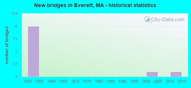
- New bridges - historical statistics
- 101950-1959
- 12000-2009
- 12010-2019

- Reconstructed bridges - Historical Statistics
- 21980-1989
- 21990-1999


- Bridge Condition - Deck
- 25.0%Good
- 37.5%Satisfactory
- 37.5%Fair

- Bridge Condition - Superstructure
- 25.0%Good
- 25.0%Satisfactory
- 50.0%Fair

- Bridge Condition - Substructure
- 12.5%Very good
- 12.5%Satisfactory
- 75.0%Fair
Find on map >> Show street view
Structure Number: E120013GHDOT634, Location: 30 M S OF JCT SR16&SR99 (Lat: 42.401589, Lng: -71.060958), Route carried "on" structure: State highway 99, Year Built: 1954, Status: Open, Structure Length: 3.93m (12.89ft), Average Daily Traffic: 41,500 (year 2018), Truck Traffic: 12%, Average Future Daily Traffic: 50,538 (year 2031), Design Load: HS 20, Features Intersected: RR MBTA/BMRR/CSX
Minimum Vertical Clearance: 30+ m (98+ ft), Kilometerpoint: 0.000, Lanes on structure: 2, Base Highway Network: Yes, Owner: State Highway Agency, Approaching Roadway Width: 11.0m (36.1ft), Material/Design: Steel, Design/Construction: Stringer/Multi-beam, Number Of Spans In Main Unit: 1, Number Of Approach Spans: 2, Length of Maximum Span: 25.9m (85.0ft), Curb or Sidewalk Widths: Left: 2.4m (7.9ft), Right: 0.9m (3.0ft), Curb-To-Curb Width: 11.0m (36.1ft), Out-to-Out Width: 15.5m (50.9ft)
Condition: Deck: Fair, Superstructure: Fair, Substructure: Fair, Operating Rating: 45.3 metric tons, Method Used To Determine Operating Rating: Load Factor (LF), Inventory Rating: 29.3 metric tons, Method Used To Determine Inventory Rating: Load Factor (LF), Structural Evaluation: Somewhat better than minimum adequacy, Deck Geometry: Equal to present minimum criteria, Underclear: High priority of corrective action, Approach Roadway Alignment: Equal to present desirable criteria, Length Of Structure Improvement: 4.00m (13.12ft), Designated Inspection Frequency: Every 24 months, Inspection Date: August 2020, Bridge Improvement Cost: $2,436,000, Roadway Improvement Cost: $244,000, Total Project Cost: $3,655,000 ( Estimate for 2022), Deck Structure Type: Concrete Cast-file-Place, Wearing Surface/Protective System: Wearing Surface: Bituminous, Membrane: Built-up
Find on map >> Show street view
Structure Number: E120024E8DOTNBI, Location: .2 MI E OF SANTILLI CIR (Lat: 42.402639, Lng: -71.063250), Route carried "on" structure: Ramp City street , Year Built: 1954, Year Reconstructed: 2002, Status: Open, Structure Length: 5.33m (17.49ft), Average Daily Traffic: 21,300 (year 2017), Truck Traffic: 5%, Average Future Daily Traffic: 41,251 (year 2032), Design Load: H 20, Features Intersected: RR MBTA/BMRR, Facility Carried by Structure: ST 16 RAMP
Minimum Vertical Clearance: 30+ m (98+ ft), Kilometerpoint: 0.853, Lanes on structure: 2, Base Highway Network: Yes, Owner: State Highway Agency, Approaching Roadway Width: 12.2m (40.0ft), Skew: 1 degrees, Material/Design: Steel, Design/Construction: Stringer/Multi-beam, Number Of Spans In Main Unit: 3, Number Of Approach Spans: 2, Length of Maximum Span: 14.0m (45.9ft), Curb or Sidewalk Widths: Left: 2.0m (6.6ft), Right: 0.9m (3.0ft), Curb-To-Curb Width: 12.2m (40.0ft), Out-to-Out Width: 15.8m (51.8ft)
Condition: Deck: Satisfactory, Superstructure: Fair, Substructure: Fair, Operating Rating: 49.7 metric tons, Method Used To Determine Operating Rating: Load Factor (LF), Inventory Rating: 29.8 metric tons, Method Used To Determine Inventory Rating: Load Factor (LF), Structural Evaluation: Somewhat better than minimum adequacy, Deck Geometry: Superior to present desirable criteria, Underclear: High priority of corrective action, Approach Roadway Alignment: Better than present minimum criteria, Length Of Structure Improvement: 5.40m (17.72ft), Designated Inspection Frequency: Every 24 months, Inspection Date: January 2021, Bridge Improvement Cost: $3,352,000, Roadway Improvement Cost: $336,000, Total Project Cost: $5,029,000 ( Estimate for 2022), Deck Structure Type: Concrete Cast-file-Place, Wearing Surface/Protective System: Wearing Surface: Bituminous, Membrane: Built-up, Deck Protection: Epoxy Coated Reinforcing
Find on map >> Show street view
Structure Number: E120033GJDOT634, Location: 305 M NW OF JCTSR16&SR99 (Lat: 42.405142, Lng: -71.063742), Route carried "on" structure: City street , Year Built: 2002, Status: Open, Structure Length: 1.31m (4.30ft), Average Daily Traffic: 4,400 (year 2018), Truck Traffic: 5%, Average Future Daily Traffic: 6,767 (year 2033), Design Load: HS 20, Features Intersected: TR NRTHRN STRAND COMM, Facility Carried by Structure: HWY TILESTON ST
Minimum Vertical Clearance: 30+ m (98+ ft), Kilometerpoint: 0.000, Lanes on structure: 2, Owner: State Highway Agency, Approaching Roadway Width: 8.2m (26.9ft), Skew: 1 degrees, Material/Design: Prestressed concrete, Design/Construction: Box Beam or Girders - Multiple, Number Of Spans In Main Unit: 1, Length of Maximum Span: 11.6m (38.1ft), Curb or Sidewalk Widths: Left: 1.5m (4.9ft), Right: 1.5m (4.9ft), Curb-To-Curb Width: 8.3m (27.2ft), Out-to-Out Width: 11.8m (38.7ft)
Condition: Deck: Good, Superstructure: Good, Substructure: Satisfactory, Operating Rating: 68.0 metric tons, Method Used To Determine Operating Rating: Load Factor (LF), Inventory Rating: 40.8 metric tons, Method Used To Determine Inventory Rating: Load Factor (LF), Structural Evaluation: Equal to present minimum criteria, Deck Geometry: High priority of corrective action, Approach Roadway Alignment: Equal to present desirable criteria, Length Of Structure Improvement: 1.40m (4.59ft), Designated Inspection Frequency: Every 24 months, Inspection Date: January 2022, Bridge Improvement Cost: $674,000, Roadway Improvement Cost: $68,000, Total Project Cost: $1,012,000 ( Estimate for 2022), Deck Structure Type: Concrete Precast Panels, Wearing Surface/Protective System: Wearing Surface: Bituminous, Membrane: Built-up, Deck Protection: Epoxy Coated Reinforcing
Find on map >> Show street view
Structure Number: E12004BGADOTNBI, Location: .2 MI W OF SANTILLI CIR (Lat: 42.403808, Lng: -71.072508), Route carried "on" structure: State highway 16, Year Built: 2018, Status: Open, Structure Length: 10.20m (33.46ft), Average Daily Traffic: 67,764 (year 2019), Truck Traffic: 6%, Design Load: HL 93, Features Intersected: WATER MALDEN RIVER
Minimum Vertical Clearance: 30+ m (98+ ft), Kilometerpoint: 0.016, Lanes on structure: 8, Owner: State Highway Agency, Approaching Roadway Width: 31.7m (104.0ft), Skew: 30 degrees, Material/Design: Steel continuous, Design/Construction: Stringer/Multi-beam, Number Of Spans In Main Unit: 3, Length of Maximum Span: 38.7m (127.0ft), Curb or Sidewalk Widths: Left: 3.0m (9.8ft), Right: 3.0m (9.8ft), Curb-To-Curb Width: 31.7m (104.0ft), Out-to-Out Width: 40.1m (131.6ft)
Condition: Deck: Good, Superstructure: Good, Substructure: Very good, Channel: Very good, Operating Rating: 64.8 metric tons, Method Used To Determine Operating Rating: Load and Resistance Factor Rating (LRFR) rating reported by rating factor(RF) method using HL-93 loadings, Inventory Rating: 51.8 metric tons, Method Used To Determine Inventory Rating: Load and Resistance Factor Rating (LRFR) rating reported by rating factor(RF) method using HL-93 loadings, Structural Evaluation: Better than present minimum criteria, Deck Geometry: Somewhat better than minimum adequacy, Waterway Adequacy: Superior to present desirable criteria, Approach Roadway Alignment: Equal to present desirable criteria, Designated Inspection Frequency: Every 24 months, Underwater Inspection Frequency: Every 36 months, Inspection Date: December 2020, Underwater Inspection Date: January 2022, Deck Structure Type: Concrete Cast-file-Place, Wearing Surface/Protective System: Wearing Surface: Bituminous, Membrane: Other, Deck Protection: Epoxy Coated Reinforcing
Find on map >> Show street view
Structure Number: E120054E7DOTNBI, Location: .2 MI E OF SANTILLI CIR (Lat: 42.401639, Lng: -71.063681), Route carried "on" structure: State highway 16, Year Built: 1956, Year Reconstructed: 2002, Status: Open, Structure Length: 7.07m (23.20ft), Average Daily Traffic: 52,800 (year 2019), Truck Traffic: 10%, Average Future Daily Traffic: 63,172 (year 2032), Design Load: H 20, Features Intersected: RR MBTA/BMRR
Minimum Vertical Clearance: 30+ m (98+ ft), Kilometerpoint: 1.609, Lanes on structure: 6, Base Highway Network: Yes, Owner: State Highway Agency, Approaching Roadway Width: 22.6m (74.1ft), Skew: 20 degrees, Material/Design: Steel, Design/Construction: Stringer/Multi-beam, Number Of Spans In Main Unit: 4, Length of Maximum Span: 19.5m (64.0ft), Curb or Sidewalk Widths: Left: 0.9m (3.0ft), Right: 0.9m (3.0ft), Curb-To-Curb Width: 22.6m (74.1ft), Out-to-Out Width: 25.2m (82.7ft)
Condition: Deck: Satisfactory, Superstructure: Fair, Substructure: Fair, Operating Rating: 62.6 metric tons, Method Used To Determine Operating Rating: Load Factor (LF), Inventory Rating: 37.5 metric tons, Method Used To Determine Inventory Rating: Load Factor (LF), Structural Evaluation: Somewhat better than minimum adequacy, Deck Geometry: Meets minimum limits, Underclear: High priority of corrective action, Approach Roadway Alignment: Better than present minimum criteria, Length Of Structure Improvement: 7.10m (23.29ft), Designated Inspection Frequency: Every 24 months, Inspection Date: January 2021, Bridge Improvement Cost: $7,028,000, Roadway Improvement Cost: $703,000, Total Project Cost: $10,543,000 ( Estimate for 2022), Deck Structure Type: Concrete Cast-file-Place, Wearing Surface/Protective System: Wearing Surface: Bituminous, Membrane: Built-up, Deck Protection: Epoxy Coated Reinforcing
Find on map >> Show street view
Structure Number: E120073GKDOT634, Location: 30 M S OF JCT SR16&SR99 (Lat: 42.401628, Lng: -71.060269), Route carried "on" structure: State highway 99, Year Built: 1956, Status: Open, Structure Length: 3.38m (11.09ft), Average Daily Traffic: 27,800 (year 2018), Truck Traffic: 10%, Average Future Daily Traffic: 36,324 (year 2031), Design Load: H 20, Features Intersected: RR MBTA/BMRR/CSX
Minimum Vertical Clearance: 30+ m (98+ ft), Kilometerpoint: 0.032, Lanes on structure: 2, Base Highway Network: Yes, Owner: State Highway Agency, Approaching Roadway Width: 11.0m (36.1ft), Material/Design: Steel, Design/Construction: Stringer/Multi-beam, Number Of Spans In Main Unit: 1, Length of Maximum Span: 32.6m (107.0ft), Curb or Sidewalk Widths: Left: 0.9m (3.0ft), Right: 1.7m (5.6ft), Curb-To-Curb Width: 11.0m (36.1ft), Out-to-Out Width: 15.5m (50.9ft)
Condition: Deck: Fair, Superstructure: Satisfactory, Substructure: Fair, Operating Rating: 56.0 metric tons, Method Used To Determine Operating Rating: Load Factor (LF), Inventory Rating: 37.2 metric tons, Method Used To Determine Inventory Rating: Load Factor (LF), Structural Evaluation: Somewhat better than minimum adequacy, Deck Geometry: Equal to present minimum criteria, Underclear: High priority of corrective action, Approach Roadway Alignment: Equal to present minimum criteria, Length Of Structure Improvement: 3.40m (11.15ft), Designated Inspection Frequency: Every 24 months, Inspection Date: August 2020, Bridge Improvement Cost: $2,071,000, Roadway Improvement Cost: $208,000, Total Project Cost: $3,107,000 ( Estimate for 2022), Deck Structure Type: Concrete Cast-file-Place, Wearing Surface/Protective System: Wearing Surface: Bituminous, Membrane: Built-up
Find on map >> Show street view
Structure Number: E120084EADOTNBI, Location: .1 MI N OF BARTLETT ST (Lat: 42.402042, Lng: -71.061042), Route carried "on" structure: State highway 99, Year Built: 1956, Year Reconstructed: 1991, Status: Open, Structure Length: 3.29m (10.79ft), Average Daily Traffic: 31,800 (year 2017), Truck Traffic: 10%, Average Future Daily Traffic: 83,545 (year 2032), Design Load: H 20, Features Intersected: ST 16 REV BCH PKWY
Minimum Vertical Clearance: 30+ m (98+ ft), Kilometerpoint: 4.120, Lanes on structure: 3, Lanes under structure: 6, Base Highway Network: Yes, Owner: State Highway Agency, Approaching Roadway Width: 16.5m (54.1ft), Material/Design: Steel, Design/Construction: Stringer/Multi-beam, Number Of Spans In Main Unit: 2, Length of Maximum Span: 18.0m (59.1ft), Curb or Sidewalk Widths: Left: 0.3m (1.0ft), Right: 0.2m (0.7ft), Curb-To-Curb Width: 15.7m (51.5ft), Out-to-Out Width: 20.3m (66.6ft)
Condition: Deck: Satisfactory, Superstructure: Satisfactory, Substructure: Fair, Operating Rating: 78.8 metric tons, Method Used To Determine Operating Rating: Load Factor (LF), Inventory Rating: 47.2 metric tons, Method Used To Determine Inventory Rating: Load Factor (LF), Structural Evaluation: Somewhat better than minimum adequacy, Deck Geometry: Better than present minimum criteria, Underclear: High priority of corrective action, Approach Roadway Alignment: Equal to present minimum criteria, Length Of Structure Improvement: 3.30m (10.83ft), Designated Inspection Frequency: Every 24 months, Inspection Date: January 2021, Bridge Improvement Cost: $2,632,000, Roadway Improvement Cost: $264,000, Total Project Cost: $3,949,000 ( Estimate for 2022), Deck Structure Type: Concrete Cast-file-Place, Wearing Surface/Protective System: Wearing Surface: Bituminous
Find on map >> Show street view
Structure Number: E120094EBDOTNBI, Location: .1 MI W OF LEWIS ST (Lat: 42.402472, Lng: -71.059736), Route carried "on" structure: State highway 99, Year Built: 1956, Year Reconstructed: 1991, Status: Open, Structure Length: 3.66m (12.01ft), Average Daily Traffic: 18,800 (year 2017), Truck Traffic: 10%, Average Future Daily Traffic: 21,478 (year 2032), Design Load: H 20, Features Intersected: ST 16 REV BCH PKWY
Minimum Vertical Clearance: 30+ m (98+ ft), Kilometerpoint: 4.120, Lanes on structure: 3, Lanes under structure: 6, Base Highway Network: Yes, Owner: State Highway Agency, Approaching Roadway Width: 16.2m (53.1ft), Skew: 1 degrees, Material/Design: Steel, Design/Construction: Stringer/Multi-beam, Number Of Spans In Main Unit: 2, Length of Maximum Span: 18.0m (59.1ft), Curb or Sidewalk Widths: Left: 1.7m (5.6ft), Right: 0.0m, Curb-To-Curb Width: 15.4m (50.5ft), Out-to-Out Width: 19.8m (65.0ft)
Condition: Deck: Fair, Superstructure: Fair, Substructure: Fair, Operating Rating: 80.6 metric tons, Method Used To Determine Operating Rating: Load Factor (LF), Inventory Rating: 48.3 metric tons, Method Used To Determine Inventory Rating: Load Factor (LF), Structural Evaluation: Somewhat better than minimum adequacy, Deck Geometry: Equal to present minimum criteria, Underclear: High priority of corrective action, Approach Roadway Alignment: Equal to present minimum criteria, Length Of Structure Improvement: 3.70m (12.14ft), Designated Inspection Frequency: Every 24 months, Inspection Date: January 2021, Bridge Improvement Cost: $2,878,000, Roadway Improvement Cost: $288,000, Total Project Cost: $4,318,000 ( Estimate for 2022), Deck Structure Type: Concrete Cast-file-Place, Wearing Surface/Protective System: Wearing Surface: Bituminous
Find on map >> Show street view
Structure Number: E120084EADOTNBI, Location: AT RT 16 (Lat: 42.400000, Lng: -71.066667), Route carried "under" structure: State highway 16, Year Built: 1956, Structure Length: 0. m, Average Daily Traffic: 18,350 (year 0000), Features Intersected: ST 16 EB REV BCH PKWY, Facility Carried by Structure: ST 99 SB
Minimum Vertical Clearance: 4.62m (15.16ft), Kilometerpoint: 3.299, Lanes on structure: 2, Lanes under structure: 3, Material/Design: Steel, Design/Construction: Stringer/Multi-beam, Length of Maximum Span: 18.0m (59.1ft)
Find on map >> Show street view
Structure Number: E120084EADOTNBI, Location: AT RT 16 (Lat: 42.400000, Lng: -71.066667), Route carried "under" structure: State highway 16, Year Built: 1956, Structure Length: 0. m, Average Daily Traffic: 1,835 (year 0000), Features Intersected: ST 16 WB, Facility Carried by Structure: ST 99 SB
Minimum Vertical Clearance: 4.62m (15.16ft), Kilometerpoint: 3.299, Lanes on structure: 2, Lanes under structure: 3, Material/Design: Steel, Design/Construction: Stringer/Multi-beam, Length of Maximum Span: 18.0m (59.1ft)
Find on map >> Show street view
Structure Number: E120094EBDOTNBI, Location: AT RT 16 (Lat: 42.400000, Lng: -71.066667), Route carried "under" structure: State highway 16, Year Built: 1956, Structure Length: 0. m, Average Daily Traffic: 18,350 (year 0000), Features Intersected: ST 16 EB REV BCH PKWY, Facility Carried by Structure: ST 99 NB
Minimum Vertical Clearance: 4.47m (14.67ft), Kilometerpoint: 3.396, Lanes on structure: 2, Lanes under structure: 3, Material/Design: Steel, Design/Construction: Stringer/Multi-beam, Length of Maximum Span: 18.0m (59.1ft)
Find on map >> Show street view
Structure Number: E120094EBDOTNBI, Location: AT RT 16 (Lat: 42.400000, Lng: -71.066667), Route carried "under" structure: State highway 16, Year Built: 1956, Structure Length: 0. m, Average Daily Traffic: 18,350 (year 0000), Features Intersected: ST 16 WB REV BCH PKWY, Facility Carried by Structure: ST 99 NB
Minimum Vertical Clearance: 4.47m (14.67ft), Kilometerpoint: 3.396, Lanes on structure: 2, Lanes under structure: 3, Material/Design: Steel, Design/Construction: Stringer/Multi-beam, Length of Maximum Span: 18.0m (59.1ft)