Bridge Statistics for Lancaster, Massachusetts (MA)
Condition, Traffic, Stress, Structural Evaluation, Project Costs
- National Bridge Inventory (NBI) Statistics
- 21Number of bridges
- 233ft / 70.8mTotal length
- $45,166,000Total costs
- 560,281Total average daily traffic
- 43,050Total average daily truck traffic
- National Bridge Inventory (NBI) Registered Bridges for Lancaster
- No street view available for this location
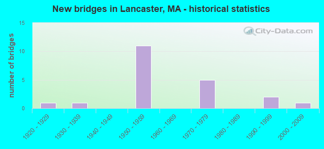
- New bridges - historical statistics
- 11920-1929
- 11930-1939
- 111950-1959
- 51970-1979
- 21990-1999
- 12000-2009

- Reconstructed bridges - Historical Statistics
- 21980-1989
- 11990-1999
- 02000-2009
- 12010-2019


- Bridge Condition - Deck
- 21.4%Very good
- 7.1%Good
- 35.7%Satisfactory
- 35.7%Fair

- Bridge Condition - Superstructure
- 21.4%Very good
- 64.3%Satisfactory
- 14.3%Fair

- Bridge Condition - Substructure
- 7.1%Very good
- 42.9%Good
- 28.6%Satisfactory
- 21.4%Fair

- Bridge Condition - Channel
- 33.3%Good
- 22.2%Satisfactory
- 33.3%Fair
- 11.1%Poor
Find on map >> Show street view
Structure Number: L02002204DOTNBI, Location: .7 MI. W. OF ST-110 (Lat: 42.461156, Lng: -71.656414), Route carried "on" structure: State highway 117, Year Built: 1927, Status: Open, Structure Length: 2.88m (9.45ft), Average Daily Traffic: 14,914 (year 2018), Truck Traffic: 15%, Average Future Daily Traffic: 28,427 (year 2031), Design Load: H 20, Features Intersected: WATER NASHUA RIVER
Minimum Vertical Clearance: 30+ m (98+ ft), Kilometerpoint: 11.458, Lanes on structure: 2, Base Highway Network: Yes, Owner: State Highway Agency, Approaching Roadway Width: 9.1m (29.9ft), Material/Design: Concrete continuous, Design/Construction: Tee Beam, Number Of Spans In Main Unit: 2, Length of Maximum Span: 14.9m (48.9ft), Curb-To-Curb Width: 9.1m (29.9ft), Out-to-Out Width: 10.5m (34.4ft)
Condition: Deck: Fair, Superstructure: Satisfactory, Substructure: Satisfactory, Channel: Fair, Operating Rating: 32.5 metric tons, Method Used To Determine Operating Rating: Load Factor (LF), Inventory Rating: 19.5 metric tons, Method Used To Determine Inventory Rating: Load Factor (LF), Structural Evaluation: Meets minimum limits, Deck Geometry: High priority of corrective action, Waterway Adequacy: Equal to present desirable criteria, Approach Roadway Alignment: Equal to present desirable criteria, Length Of Structure Improvement: 2.90m (9.51ft), Designated Inspection Frequency: Every 24 months, Underwater Inspection Frequency: Every 36 months, Inspection Date: August 2021, Underwater Inspection Date: January 2020, Bridge Improvement Cost: $1,199,000, Roadway Improvement Cost: $120,000, Total Project Cost: $1,799,000 ( Estimate for 2022), Deck Structure Type: Concrete Cast-file-Place, Wearing Surface/Protective System: Wearing Surface: Bituminous, Membrane: Built-up
Find on map >> Show street view
Structure Number: L020031C3MUNNBI, Location: .2 MI NW OF RTE 110 (Lat: 42.447450, Lng: -71.669100), Route carried "on" structure: City street , Year Built: 1937, Year Reconstructed: 1995, Status: Open, Structure Length: 5.00m (16.40ft), Average Daily Traffic: 5,177 (year 2018), Truck Traffic: 5%, Average Future Daily Traffic: 5,212 (year 2032), Design Load: H 20, Features Intersected: WATER NASHUA RIVER, Facility Carried by Structure: HWY CENTR BRG RD
Minimum Vertical Clearance: 30+ m (98+ ft), Kilometerpoint: 0.435, Lanes on structure: 2, Owner: Town or Township Highway Agency, Approaching Roadway Width: 9.1m (29.9ft), Material/Design: Steel continuous, Design/Construction: Stringer/Multi-beam, Number Of Spans In Main Unit: 2, Length of Maximum Span: 23.2m (76.1ft), Curb or Sidewalk Widths: Left: 1.5m (4.9ft), Right: 0.3m (1.0ft), Curb-To-Curb Width: 9.1m (29.9ft), Out-to-Out Width: 11.8m (38.7ft)
Condition: Deck: Good, Superstructure: Satisfactory, Substructure: Good, Channel: Fair, Operating Rating: 57.0 metric tons, Method Used To Determine Operating Rating: Load Factor (LF), Inventory Rating: 34.2 metric tons, Method Used To Determine Inventory Rating: Load Factor (LF), Structural Evaluation: Equal to present minimum criteria, Deck Geometry: High priority of corrective action, Waterway Adequacy: Somewhat better than minimum adequacy, Approach Roadway Alignment: Better than present minimum criteria, Length Of Structure Improvement: 5.10m (16.73ft), Designated Inspection Frequency: Every 24 months, Underwater Inspection Frequency: Every 36 months, Inspection Date: November 2021, Underwater Inspection Date: March 2021, Bridge Improvement Cost: $2,068,000, Roadway Improvement Cost: $207,000, Total Project Cost: $3,103,000 ( Estimate for 2022), Deck Structure Type: Concrete Cast-file-Place, Wearing Surface/Protective System: Wearing Surface: Bituminous, Membrane: Built-up, Deck Protection: Epoxy Coated Reinforcing
Find on map >> Show street view
Structure Number: L02005AE0MUNNBI, Location: .2 MI. WEST OF ST. 110 (Lat: 42.438517, Lng: -71.681156), Route carried "on" structure: City street , Year Built: 1996, Status: Open, Structure Length: 3.20m (10.50ft), Average Daily Traffic: 3,531 (year 2019), Truck Traffic: 7%, Average Future Daily Traffic: 4,580 (year 2031), Design Load: HS 20, Features Intersected: WATER NASHUA RIVER, Facility Carried by Structure: HWY MILL ST
Minimum Vertical Clearance: 99.00m (324.80ft), Kilometerpoint: 0.531, Lanes on structure: 2, Owner: Town or Township Highway Agency, Approaching Roadway Width: 7.9m (25.9ft), Material/Design: Prestressed concrete, Design/Construction: Box Beam or Girders - Single/Spread, Number Of Spans In Main Unit: 1, Length of Maximum Span: 30.0m (98.4ft), Curb or Sidewalk Widths: Left: 1.8m (5.9ft), Right: 0.0m, Curb-To-Curb Width: 7.9m (25.9ft), Out-to-Out Width: 10.5m (34.4ft)
Condition: Deck: Very good, Superstructure: Very good, Substructure: Good, Channel: Good, Operating Rating: 87.4 metric tons, Method Used To Determine Operating Rating: Load Factor (LF), Inventory Rating: 52.3 metric tons, Method Used To Determine Inventory Rating: Load Factor (LF), Structural Evaluation: Better than present minimum criteria, Deck Geometry: High priority of corrective action, Waterway Adequacy: Equal to present desirable criteria, Approach Roadway Alignment: Better than present minimum criteria, Length Of Structure Improvement: 3.30m (10.83ft), Designated Inspection Frequency: Every 24 months, Inspection Date: December 2020, Bridge Improvement Cost: $1,712,000, Roadway Improvement Cost: $172,000, Total Project Cost: $2,569,000 ( Estimate for 2022), Deck Structure Type: Concrete Cast-file-Place, Wearing Surface/Protective System: Wearing Surface: Bituminous, Membrane: Built-up, Deck Protection: Epoxy Coated Reinforcing
Find on map >> Show street view
Structure Number: L020061C4MUNNBI, Location: .1 MI S OF CENTER BR RD (Lat: 42.451356, Lng: -71.673767), Route carried "on" structure: City street , Year Built: 1955, Year Reconstructed: 1987, Status: Open, Structure Length: 4.18m (13.71ft), Average Daily Traffic: 6,482 (year 2019), Truck Traffic: 5%, Average Future Daily Traffic: 15,003 (year 2031), Design Load: HS 20, Features Intersected: WATER N NASHUA RIVER, Facility Carried by Structure: ST 70 MAIN ST
Minimum Vertical Clearance: 30+ m (98+ ft), Kilometerpoint: 25.346, Lanes on structure: 2, Owner: Town or Township Highway Agency, Approaching Roadway Width: 9.1m (29.9ft), Skew: 1 degrees, Material/Design: Steel continuous, Design/Construction: Stringer/Multi-beam, Number Of Spans In Main Unit: 3, Length of Maximum Span: 25.0m (82.0ft), Curb or Sidewalk Widths: Left: 1.5m (4.9ft), Right: 0.2m (0.7ft), Curb-To-Curb Width: 9.3m (30.5ft), Out-to-Out Width: 11.8m (38.7ft)
Condition: Deck: Satisfactory, Superstructure: Satisfactory, Substructure: Satisfactory, Channel: Fair, Operating Rating: 58.7 metric tons, Method Used To Determine Operating Rating: Load Factor (LF), Inventory Rating: 35.2 metric tons, Method Used To Determine Inventory Rating: Load Factor (LF), Structural Evaluation: Equal to present minimum criteria, Deck Geometry: High priority of corrective action, Waterway Adequacy: Better than present minimum criteria, Approach Roadway Alignment: Better than present minimum criteria, Length Of Structure Improvement: 4.20m (13.78ft), Designated Inspection Frequency: Every 24 months, Inspection Date: September 2020, Bridge Improvement Cost: $1,624,000, Roadway Improvement Cost: $163,000, Total Project Cost: $2,437,000 ( Estimate for 2022), Deck Structure Type: Concrete Cast-file-Place, Wearing Surface/Protective System: Wearing Surface: Latex Concrete, Deck Protection: Epoxy Coated Reinforcing
Find on map >> Show street view
Structure Number: L02007AQXDOTNBI, Location: AT CORNER OF LANGEN RD. (Lat: 42.473147, Lng: -71.682217), Route carried "on" structure: State highway 1117, Year Built: 2001, Status: Open, Structure Length: 4.07m (13.35ft), Average Daily Traffic: 11,102 (year 2020), Truck Traffic: 10%, Average Future Daily Traffic: 27,322 (year 2033), Design Load: HS 20, Features Intersected: WATER N NASHUA RIVER, Facility Carried by Structure: ST117 N MAIN ST
Minimum Vertical Clearance: 30+ m (98+ ft), Kilometerpoint: 8.200, Lanes on structure: 2, Owner: State Highway Agency, Approaching Roadway Width: 10.5m (34.4ft), Material/Design: Steel, Design/Construction: Stringer/Multi-beam, Number Of Spans In Main Unit: 1, Length of Maximum Span: 40.0m (131.2ft), Curb or Sidewalk Widths: Left: 0.0m, Right: 2.0m (6.6ft), Curb-To-Curb Width: 10.5m (34.4ft), Out-to-Out Width: 13.3m (43.6ft)
Condition: Deck: Very good, Superstructure: Very good, Substructure: Very good, Channel: Satisfactory, Operating Rating: 82.2 metric tons, Method Used To Determine Operating Rating: Load Factor (LF), Inventory Rating: 49.2 metric tons, Method Used To Determine Inventory Rating: Load Factor (LF), Structural Evaluation: Equal to present desirable criteria, Deck Geometry: Meets minimum limits, Waterway Adequacy: Superior to present desirable criteria, Approach Roadway Alignment: Equal to present desirable criteria, Length Of Structure Improvement: 4.10m (13.45ft), Designated Inspection Frequency: Every 24 months, Inspection Date: Febuary 2022, Bridge Improvement Cost: $1,122,000, Roadway Improvement Cost: $113,000, Total Project Cost: $1,684,000 ( Estimate for 2022), Deck Structure Type: Concrete Cast-file-Place, Wearing Surface/Protective System: Wearing Surface: Bituminous, Membrane: Built-up, Deck Protection: Epoxy Coated Reinforcing
Find on map >> Show street view
Structure Number: L020141NRDOTNBI, Location: .5 MI E OF I-190 (Lat: 42.521553, Lng: -71.710633), Route carried "on" structure: State highway 2, Year Built: 1951, Status: Open, Structure Length: 1.46m (4.79ft), Average Daily Traffic: 43,369 (year 2020), Truck Traffic: 15%, Average Future Daily Traffic: 72,648 (year 2033), Design Load: H 20, Features Intersected: HWY HARVARD ST
Minimum Vertical Clearance: 30+ m (98+ ft), Kilometerpoint: 165.190, Lanes on structure: 4, Lanes under structure: 2, Base Highway Network: Yes, Owner: State Highway Agency, Approaching Roadway Width: 23.2m (76.1ft), Skew: 20 degrees, Material/Design: Steel, Design/Construction: Stringer/Multi-beam, Number Of Spans In Main Unit: 1, Length of Maximum Span: 13.1m (43.0ft), Curb-To-Curb Width: 23.2m (76.1ft), Out-to-Out Width: 27.7m (90.9ft)
Condition: Deck: Fair, Superstructure: Satisfactory, Substructure: Fair, Operating Rating: 45.6 metric tons, Method Used To Determine Operating Rating: Load Factor (LF), Inventory Rating: 27.3 metric tons, Method Used To Determine Inventory Rating: Load Factor (LF), Structural Evaluation: Somewhat better than minimum adequacy, Deck Geometry: Superior to present desirable criteria, Underclear: Meets minimum limits, Approach Roadway Alignment: Equal to present desirable criteria, Length Of Structure Improvement: 1.50m (4.92ft), Designated Inspection Frequency: Every 24 months, Inspection Date: Febuary 2022, Bridge Improvement Cost: $1,633,000, Roadway Improvement Cost: $164,000, Total Project Cost: $2,450,000 ( Estimate for 2022), Deck Structure Type: Concrete Cast-file-Place, Wearing Surface/Protective System: Wearing Surface: Bituminous, Membrane: Built-up
Find on map >> Show street view
Structure Number: L0201520UDOTNBI, Location: 1.5 MI W OF SHIRLEY RD (Lat: 42.519683, Lng: -71.692497), Route carried "on" structure: State highway , Year Built: 1951, Status: Open, Structure Length: 5.61m (18.41ft), Average Daily Traffic: 8,508 (year 2018), Truck Traffic: 14%, Average Future Daily Traffic: 25,269 (year 2032), Design Load: H 20, Features Intersected: ST 2, Facility Carried by Structure: ST 70 LUNENBURG RD
Minimum Vertical Clearance: 30+ m (98+ ft), Kilometerpoint: 33.432, Lanes on structure: 2, Lanes under structure: 4, Owner: State Highway Agency, Approaching Roadway Width: 9.1m (29.9ft), Skew: 1 degrees, Material/Design: Steel continuous, Design/Construction: Stringer/Multi-beam, Number Of Spans In Main Unit: 3, Length of Maximum Span: 18.3m (60.0ft), Curb or Sidewalk Widths: Left: 1.2m (3.9ft), Right: 1.2m (3.9ft), Curb-To-Curb Width: 4.6m (15.1ft), Out-to-Out Width: 11.7m (38.4ft)
Condition: Deck: Fair, Superstructure: Satisfactory, Substructure: Good, Operating Rating: 45.5 metric tons, Method Used To Determine Operating Rating: Load Factor (LF), Inventory Rating: 27.2 metric tons, Method Used To Determine Inventory Rating: Load Factor (LF), Structural Evaluation: Equal to present minimum criteria, Deck Geometry: High priority of replacement, Underclear: High priority of corrective action, Approach Roadway Alignment: Equal to present desirable criteria, Length Of Structure Improvement: 5.70m (18.70ft), Designated Inspection Frequency: Every 24 months, Inspection Date: March 2021, Bridge Improvement Cost: $2,620,000, Roadway Improvement Cost: $263,000, Total Project Cost: $3,931,000 ( Estimate for 2022), Deck Structure Type: Concrete Cast-file-Place, Wearing Surface/Protective System: Wearing Surface: Bituminous, Membrane: Built-up
Find on map >> Show street view
Structure Number: L0201620GDOTNBI, Location: RT 2 STATION 135+00 (Lat: 42.516350, Lng: -71.664547), Route carried "on" structure: City street , Year Built: 1951, Year Reconstructed: 1993, Status: Open, Structure Length: 4.60m (15.09ft), Average Daily Traffic: 4,492 (year 2013), Truck Traffic: 6%, Average Future Daily Traffic: 3,474 (year 2032), Design Load: H 20, Features Intersected: ST 2, Facility Carried by Structure: HWY SHIRLEY RD
Minimum Vertical Clearance: 30+ m (98+ ft), Kilometerpoint: 4.186, Lanes on structure: 2, Lanes under structure: 5, Owner: State Highway Agency, Approaching Roadway Width: 9.1m (29.9ft), Material/Design: Steel continuous, Design/Construction: Stringer/Multi-beam, Number Of Spans In Main Unit: 2, Length of Maximum Span: 22.6m (74.1ft), Curb or Sidewalk Widths: Left: 0.9m (3.0ft), Right: 0.9m (3.0ft), Curb-To-Curb Width: 9.1m (29.9ft), Out-to-Out Width: 11.7m (38.4ft)
Condition: Deck: Satisfactory, Superstructure: Satisfactory, Substructure: Good, Operating Rating: 47.3 metric tons, Method Used To Determine Operating Rating: Load Factor (LF), Inventory Rating: 28.4 metric tons, Method Used To Determine Inventory Rating: Load Factor (LF), Structural Evaluation: Equal to present minimum criteria, Deck Geometry: Meets minimum limits, Underclear: High priority of corrective action, Approach Roadway Alignment: Equal to present desirable criteria, Length Of Structure Improvement: 4.70m (15.42ft), Designated Inspection Frequency: Every 24 months, Inspection Date: March 2021, Bridge Improvement Cost: $2,161,000, Roadway Improvement Cost: $217,000, Total Project Cost: $3,242,000 ( Estimate for 2022), Deck Structure Type: Concrete Cast-file-Place, Wearing Surface/Protective System: Wearing Surface: Bituminous, Membrane: Built-up
Find on map >> Show street view
Structure Number: L0201823UDOTNBI, Location: .1 MI. W. OF HARVARD TL. (Lat: 42.520939, Lng: -71.635750), Route carried "on" structure: Other road , Year Built: 1951, Year Reconstructed: 2017, Status: Open, Structure Length: 4.21m (13.81ft), Average Daily Traffic: 3,900 (year 2012), Truck Traffic: 12%, Average Future Daily Traffic: 6,159 (year 2031), Design Load: HS 20, Features Intersected: ST 2, Facility Carried by Structure: HWY JACKSON RD
Minimum Vertical Clearance: 30+ m (98+ ft), Kilometerpoint: 0.000, Lanes on structure: 2, Lanes under structure: 4, Owner: State Highway Agency, Approaching Roadway Width: 13.1m (43.0ft), Skew: 3 degrees, Material/Design: Steel, Design/Construction: Stringer/Multi-beam, Number Of Spans In Main Unit: 2, Length of Maximum Span: 19.2m (63.0ft), Curb or Sidewalk Widths: Left: 0.5m (1.6ft), Right: 0.5m (1.6ft), Curb-To-Curb Width: 13.1m (43.0ft), Out-to-Out Width: 14.0m (45.9ft)
Condition: Deck: Very good, Superstructure: Very good, Substructure: Good, Operating Rating: 48.6 metric tons, Method Used To Determine Operating Rating: Load and Resistance Factor Rating (LRFR) rating reported by rating factor(RF) method using HL-93 loadings, Inventory Rating: 35.6 metric tons, Method Used To Determine Inventory Rating: Load and Resistance Factor Rating (LRFR) rating reported by rating factor(RF) method using HL-93 loadings, Structural Evaluation: Better than present minimum criteria, Deck Geometry: Equal to present minimum criteria, Underclear: High priority of corrective action, Approach Roadway Alignment: Equal to present desirable criteria, Designated Inspection Frequency: Every 24 months, Inspection Date: October 2021, Deck Structure Type: Concrete Cast-file-Place, Wearing Surface/Protective System: Wearing Surface: Monolithic Concrete, Deck Protection: Epoxy Coated Reinforcing
Find on map >> Show street view
Structure Number: L020221VQDOTNBI, Location: 200 FT E OF LEOMINSTER TL (Lat: 42.490750, Lng: -71.723353), Route carried "on" structure: Interstate 190, Year Built: 1977, Status: Open, Structure Length: 6.46m (21.19ft), Average Daily Traffic: 17,686 (year 2018), Truck Traffic: 8%, Average Future Daily Traffic: 37,903 (year 2032), Design Load: HS 20+Mod, Features Intersected: ST117 N MAIN ST
Minimum Vertical Clearance: 30+ m (98+ ft), Kilometerpoint: 26.393, Lanes on structure: 2, Lanes under structure: 2, Base Highway Network: Yes, Owner: State Highway Agency, Approaching Roadway Width: 11.6m (38.1ft), Skew: 12 degrees, Material/Design: Steel continuous, Design/Construction: Stringer/Multi-beam, Number Of Spans In Main Unit: 3, Length of Maximum Span: 30.2m (99.1ft), Curb-To-Curb Width: 12.8m (42.0ft), Out-to-Out Width: 13.7m (44.9ft)
Condition: Deck: Satisfactory, Superstructure: Satisfactory, Substructure: Satisfactory, Operating Rating: 64.0 metric tons, Method Used To Determine Operating Rating: Load Factor (LF), Inventory Rating: 38.3 metric tons, Method Used To Determine Inventory Rating: Load Factor (LF), Structural Evaluation: Equal to present minimum criteria, Deck Geometry: Equal to present desirable criteria, Underclear: Better than present minimum criteria, Approach Roadway Alignment: Equal to present desirable criteria, Length Of Structure Improvement: 6.50m (21.33ft), Designated Inspection Frequency: Every 24 months, Inspection Date: September 2021, Bridge Improvement Cost: $700,000, Roadway Improvement Cost: $71,000, Total Project Cost: $1,051,000 ( Estimate for 2022), Deck Structure Type: Concrete Cast-file-Place, Wearing Surface/Protective System: Wearing Surface: Bituminous, Membrane: Built-up
Find on map >> Show street view
Structure Number: L020221VRDOTNBI, Location: .5 MI. S. OF NASHUA RIVER (Lat: 42.491006, Lng: -71.723964), Route carried "on" structure: Interstate 190, Year Built: 1977, Status: Open, Structure Length: 6.46m (21.19ft), Average Daily Traffic: 19,526 (year 2020), Truck Traffic: 15%, Average Future Daily Traffic: 31,586 (year 2032), Design Load: HS 20+Mod, Features Intersected: ST117 N MAIN ST
Minimum Vertical Clearance: 30+ m (98+ ft), Kilometerpoint: 26.393, Lanes on structure: 2, Lanes under structure: 5, Base Highway Network: Yes, Owner: State Highway Agency, Approaching Roadway Width: 11.6m (38.1ft), Skew: 12 degrees, Material/Design: Steel continuous, Design/Construction: Stringer/Multi-beam, Number Of Spans In Main Unit: 3, Length of Maximum Span: 30.2m (99.1ft), Curb-To-Curb Width: 12.8m (42.0ft), Out-to-Out Width: 13.7m (44.9ft)
Condition: Deck: Satisfactory, Superstructure: Satisfactory, Substructure: Good, Operating Rating: 49.6 metric tons, Method Used To Determine Operating Rating: Load Factor (LF), Inventory Rating: 31.4 metric tons, Method Used To Determine Inventory Rating: Load Factor (LF), Structural Evaluation: Equal to present minimum criteria, Deck Geometry: Equal to present desirable criteria, Underclear: Better than present minimum criteria, Approach Roadway Alignment: Equal to present desirable criteria, Length Of Structure Improvement: 6.50m (21.33ft), Designated Inspection Frequency: Every 24 months, Inspection Date: September 2021, Bridge Improvement Cost: $3,498,000, Roadway Improvement Cost: $350,000, Total Project Cost: $5,248,000 ( Estimate for 2022), Deck Structure Type: Concrete Cast-file-Place, Wearing Surface/Protective System: Wearing Surface: Bituminous, Membrane: Built-up
Find on map >> Show street view
Structure Number: L020231VTDOTNBI, Location: I-190 MM 17.2 (Lat: 42.495667, Lng: -71.723061), Route carried "on" structure: Interstate 190, Year Built: 1977, Status: Open, Structure Length: 9.51m (31.20ft), Average Daily Traffic: 25,391 (year 2019), Truck Traffic: 15%, Average Future Daily Traffic: 39,482 (year 2031), Design Load: HS 20, Features Intersected: WATER N NASHUA RIVER
Minimum Vertical Clearance: 30+ m (98+ ft), Kilometerpoint: 26.907, Lanes on structure: 3, Base Highway Network: Yes, Owner: State Highway Agency, Approaching Roadway Width: 10.7m (35.1ft), Skew: 2 degrees, Material/Design: Steel continuous, Design/Construction: Stringer/Multi-beam, Number Of Spans In Main Unit: 3, Length of Maximum Span: 42.7m (140.1ft), Curb or Sidewalk Widths: Left: 0.2m (0.7ft), Right: 0.2m (0.7ft), Curb-To-Curb Width: 12.8m (42.0ft), Out-to-Out Width: 13.7m (44.9ft)
Condition: Deck: Fair, Superstructure: Fair, Substructure: Fair, Channel: Good, Operating Rating: 68.3 metric tons, Method Used To Determine Operating Rating: Load Factor (LF), Inventory Rating: 38.7 metric tons, Method Used To Determine Inventory Rating: Load Factor (LF), Structural Evaluation: Somewhat better than minimum adequacy, Deck Geometry: Meets minimum limits, Waterway Adequacy: Superior to present desirable criteria, Approach Roadway Alignment: Superior to present desirable criteria, Length Of Structure Improvement: 9.60m (31.50ft), Designated Inspection Frequency: Every 24 months, Inspection Date: August 2020, Bridge Improvement Cost: $5,167,000, Roadway Improvement Cost: $517,000, Total Project Cost: $7,751,000 ( Estimate for 2022), Deck Structure Type: Concrete Cast-file-Place, Wearing Surface/Protective System: Wearing Surface: Bituminous, Membrane: Built-up
Find on map >> Show street view
Structure Number: L020231VUDOTNBI, Location: 0.3 MI NORTH OF ST-117 (Lat: 42.495389, Lng: -71.722492), Route carried "on" structure: Interstate 190, Year Built: 1977, Status: Open, Structure Length: 9.51m (31.20ft), Average Daily Traffic: 226,949 (year 2019), Truck Traffic: 7%, Average Future Daily Traffic: 46,273 (year 2031), Design Load: HS 20, Features Intersected: WATER N NASHUA RIVER
Minimum Vertical Clearance: 30+ m (98+ ft), Kilometerpoint: 26.901, Lanes on structure: 3, Base Highway Network: Yes, Owner: State Highway Agency, Approaching Roadway Width: 11.6m (38.1ft), Skew: 2 degrees, Material/Design: Steel continuous, Design/Construction: Stringer/Multi-beam, Number Of Spans In Main Unit: 3, Length of Maximum Span: 42.7m (140.1ft), Curb or Sidewalk Widths: Left: 0.2m (0.7ft), Right: 0.2m (0.7ft), Curb-To-Curb Width: 13.7m (44.9ft), Out-to-Out Width: 14.8m (48.6ft)
Condition: Deck: Fair, Superstructure: Fair, Substructure: Fair, Channel: Satisfactory, Operating Rating: 49.5 metric tons, Method Used To Determine Operating Rating: Load Factor (LF), Inventory Rating: 34.5 metric tons, Method Used To Determine Inventory Rating: Load Factor (LF), Structural Evaluation: Somewhat better than minimum adequacy, Deck Geometry: Meets minimum limits, Waterway Adequacy: Superior to present desirable criteria, Approach Roadway Alignment: Superior to present desirable criteria, Length Of Structure Improvement: 9.60m (31.50ft), Designated Inspection Frequency: Every 24 months, Inspection Date: August 2020, Bridge Improvement Cost: $5,581,000, Roadway Improvement Cost: $559,000, Total Project Cost: $8,372,000 ( Estimate for 2022), Deck Structure Type: Concrete Cast-file-Place, Wearing Surface/Protective System: Wearing Surface: Bituminous, Membrane: Built-up
Find on map >> Show street view
Structure Number: L020241VPDOTNBI, Location: .5 MI S OF ST-117 (Lat: 42.477511, Lng: -71.722917), Route carried "on" structure: Interstate 190, Year Built: 1978, Status: Open, Structure Length: 0.70m (2.30ft), Average Daily Traffic: 41,000 (year 2015), Truck Traffic: 15%, Average Future Daily Traffic: 64,751 (year 2031), Design Load: HS 20+Mod, Features Intersected: WATER WEKEPEKE BROOK
Minimum Vertical Clearance: 30+ m (98+ ft), Kilometerpoint: 0.000, Lanes on structure: 4, Base Highway Network: Yes, Owner: State Highway Agency, Approaching Roadway Width: 70.1m (230.0ft), Skew: 23 degrees, Material/Design: Concrete, Design/Construction: Culvert, Number Of Spans In Main Unit: 1, Length of Maximum Span: 6.1m (20.0ft)
Condition: Channel: Good, Culverts: Good, Structural Evaluation: Better than present minimum criteria, Waterway Adequacy: Equal to present desirable criteria, Approach Roadway Alignment: Equal to present desirable criteria, Designated Inspection Frequency: Every 24 months, Inspection Date: April 2020
Find on map >> Show street view
Structure Number: L020251C6MUNNBI, Location: .25 MI W OF ST-110 (Lat: 42.444594, Lng: -71.671950), Route carried "on" structure: City street , Year Built: 1990, Status: Open, Structure Length: 2.93m (9.61ft), Average Daily Traffic: 4,254 (year 2020), Truck Traffic: 6%, Average Future Daily Traffic: 4,580 (year 2032), Design Load: HS 20, Features Intersected: WATER NASHUA RIVER, Facility Carried by Structure: HWY BOLTON RD
Minimum Vertical Clearance: 30+ m (98+ ft), Kilometerpoint: 1.207, Lanes on structure: 2, Owner: Town or Township Highway Agency, Approaching Roadway Width: 9.8m (32.2ft), Skew: 1 degrees, Material/Design: Prestressed concrete, Design/Construction: Box Beam or Girders - Multiple, Number Of Spans In Main Unit: 1, Length of Maximum Span: 27.4m (89.9ft), Curb or Sidewalk Widths: Left: 1.5m (4.9ft), Right: 0.2m (0.7ft), Curb-To-Curb Width: 9.8m (32.2ft), Out-to-Out Width: 12.2m (40.0ft)
Condition: Deck: Satisfactory, Superstructure: Satisfactory, Substructure: Satisfactory, Channel: Poor, Operating Rating: 77.4 metric tons, Method Used To Determine Operating Rating: Load Factor (LF), Inventory Rating: 53.1 metric tons, Method Used To Determine Inventory Rating: Load Factor (LF), Structural Evaluation: Equal to present minimum criteria, Deck Geometry: Meets minimum limits, Waterway Adequacy: Better than present minimum criteria, Approach Roadway Alignment: Equal to present desirable criteria, Length Of Structure Improvement: 3.00m (9.84ft), Designated Inspection Frequency: Every 12 months, Other Special Inspection Frequency: Every 12 months, Inspection Date: September 2021, Bridge Improvement Cost: $1,019,000, Roadway Improvement Cost: $102,000, Total Project Cost: $1,529,000 ( Estimate for 2022), Deck Structure Type: Concrete Precast Panels, Wearing Surface/Protective System: Wearing Surface: Bituminous, Membrane: Built-up, Deck Protection: Epoxy Coated Reinforcing
Find on map >> Show street view
Structure Number: L0201520UDOTNBI, Location: LUNENBURG RD/ ST 2 (Lat: 42.516667, Lng: -71.683333), Route carried "under" structure: State highway 2, Year Built: 1951, Structure Length: 0. m, Average Daily Traffic: 16,000 (year 0000), Features Intersected: ST 2 EB, Facility Carried by Structure: HWY LUNENBURG RD
Minimum Vertical Clearance: 4.88m (16.01ft), Kilometerpoint: 0.000, Lanes on structure: 2, Lanes under structure: 2, Material/Design: Steel continuous, Design/Construction: Stringer/Multi-beam, Length of Maximum Span: 18.3m (60.0ft)
Find on map >> Show street view
Structure Number: L0201520UDOTNBI, Location: LUNENBURG RD/ ST 2 (Lat: 42.516667, Lng: -71.683333), Route carried "under" structure: State highway 2, Year Built: 1951, Structure Length: 0. m, Average Daily Traffic: 16,000 (year 0000), Features Intersected: ST 2 WB, Facility Carried by Structure: HWY LUNENBURG RD
Minimum Vertical Clearance: 4.88m (16.01ft), Kilometerpoint: 0.000, Lanes on structure: 2, Lanes under structure: 2, Material/Design: Steel continuous, Design/Construction: Stringer/Multi-beam, Length of Maximum Span: 18.3m (60.0ft)
Find on map >> Show street view
Structure Number: L0201620GDOTNBI, Location: RT 2 STATION 135+00 (Lat: 42.516667, Lng: -71.666667), Route carried "under" structure: State highway 2, Year Built: 1951, Structure Length: 0. m, Average Daily Traffic: 16,000 (year 0000), Features Intersected: ST 2 EB, Facility Carried by Structure: HWY SHIRLEY RD
Minimum Vertical Clearance: 4.39m (14.40ft), Kilometerpoint: 22.611, Lanes on structure: 2, Lanes under structure: 2, Material/Design: Steel continuous, Design/Construction: Stringer/Multi-beam, Length of Maximum Span: 22.6m (74.1ft)
Find on map >> Show street view
Structure Number: L0201620GDOTNBI, Location: RT 2 STATION 135+00 (Lat: 42.516667, Lng: -71.666667), Route carried "under" structure: State highway 2, Year Built: 1951, Structure Length: 0. m, Average Daily Traffic: 16,000 (year 0000), Features Intersected: ST 2 WB, Facility Carried by Structure: HWY SHIRLEY RD
Minimum Vertical Clearance: 4.39m (14.40ft), Kilometerpoint: 22.611, Lanes on structure: 2, Lanes under structure: 2, Material/Design: Steel continuous, Design/Construction: Stringer/Multi-beam, Length of Maximum Span: 22.6m (74.1ft)
Find on map >> Show street view
Structure Number: L0201823UDOTNBI, Location: JACKSON RD.OVER ST.2 (Lat: 42.516667, Lng: -71.633333), Route carried "under" structure: State highway 2, Year Built: 1951, Structure Length: 0. m, Average Daily Traffic: 30,000 (year 0000), Features Intersected: ST 2 WB, Facility Carried by Structure: HWY JACKSON RD
Minimum Vertical Clearance: 4.37m (14.34ft), Kilometerpoint: 0.000, Lanes on structure: 2, Lanes under structure: 2, Material/Design: Steel, Design/Construction: Stringer/Multi-beam, Length of Maximum Span: 20.7m (67.9ft)
Find on map >> Show street view
Structure Number: L0201823UDOTNBI, Location: JACKSON RD.OVER ST.2 (Lat: 42.516667, Lng: -71.633333), Route carried "under" structure: State highway 2, Year Built: 1951, Structure Length: 0. m, Average Daily Traffic: 30,000 (year 0000), Features Intersected: ST 2 EB, Facility Carried by Structure: HWY JACKSON RD
Minimum Vertical Clearance: 4.37m (14.34ft), Kilometerpoint: 0.000, Lanes on structure: 2, Lanes under structure: 2, Material/Design: Steel, Design/Construction: Stringer/Multi-beam, Length of Maximum Span: 20.7m (67.9ft)