Bridge Statistics for Lexington, Massachusetts (MA)
Condition, Traffic, Stress, Structural Evaluation, Project Costs
- National Bridge Inventory (NBI) Statistics
- 14Number of bridges
- 262ft / 80.4mTotal length
- $95,283,000Total costs
- 666,938Total average daily traffic
- 48,279Total average daily truck traffic
- 922,625Total future (year 2032) average daily traffic
- National Bridge Inventory (NBI) Registered Bridges for Lexington
- No street view available for this location
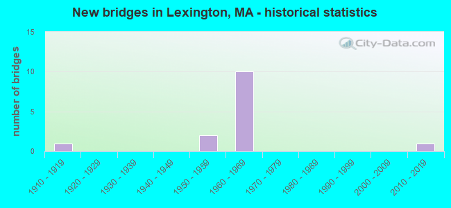
- New bridges - historical statistics
- 11910-1919
- 21950-1959
- 101960-1969
- 12010-2019

- Reconstructed bridges - Historical Statistics
- 11950-1959
- 01960-1969
- 01970-1979
- 01980-1989
- 11990-1999


- Bridge Condition - Deck
- 7.1%Good
- 42.9%Satisfactory
- 42.9%Fair
- 7.1%Poor

- Bridge Condition - Superstructure
- 7.1%Very good
- 42.9%Satisfactory
- 35.7%Fair
- 14.3%Poor

- Bridge Condition - Substructure
- 14.3%Good
- 35.7%Satisfactory
- 42.9%Fair
- 7.1%Poor
Find on map >> Show street view
Structure Number: L100012N1DOT634, Location: .16 KM E RT 2A & MASS AVE (Lat: 42.435697, Lng: -71.208967), Route carried "on" structure: Alternate State highway 2A, Year Built: 1919, Year Reconstructed: 1997, Status: Open, Structure Length: 1.65m (5.41ft), Average Daily Traffic: 12,000 (year 2017), Truck Traffic: 11%, Average Future Daily Traffic: 18,162 (year 2032), Design Load: HS 20, Features Intersected: OTHER MINUTEMAN BIKE PTH, Facility Carried by Structure: ST 2 A/MAPLE ST
Minimum Vertical Clearance: 30+ m (98+ ft), Kilometerpoint: 141.691, Lanes on structure: 2, Owner: State Highway Agency, Approaching Roadway Width: 8.5m (27.9ft), Material/Design: Prestressed concrete, Design/Construction: Slab, Number Of Spans In Main Unit: 1, Length of Maximum Span: 15.4m (50.5ft), Curb or Sidewalk Widths: Left: 1.8m (5.9ft), Right: 0.0m, Curb-To-Curb Width: 8.5m (27.9ft), Out-to-Out Width: 11.1m (36.4ft)
Condition: Deck: Satisfactory, Superstructure: Satisfactory, Substructure: Good, Operating Rating: 52.7 metric tons, Method Used To Determine Operating Rating: Allowable Stress (AS), Inventory Rating: 42.3 metric tons, Method Used To Determine Inventory Rating: Allowable Stress (AS), Structural Evaluation: Equal to present minimum criteria, Deck Geometry: High priority of replacement, Approach Roadway Alignment: Better than present minimum criteria, Length Of Structure Improvement: 1.70m (5.58ft), Designated Inspection Frequency: Every 24 months, Inspection Date: October 2021, Bridge Improvement Cost: $786,000, Roadway Improvement Cost: $79,000, Total Project Cost: $1,180,000 ( Estimate for 2022), Deck Structure Type: Concrete Precast Panels, Wearing Surface/Protective System: Wearing Surface: Bituminous, Membrane: Built-up, Deck Protection: Epoxy Coated Reinforcing
Find on map >> Show street view
Structure Number: L10009BHMDOTNBI, Location: 1.6 KM S RT 2A & RT 128 (Lat: 42.428047, Lng: -71.258569), Route carried "on" structure: State highway 2, Year Built: 2016, Status: Open, Structure Length: 10.52m (34.51ft), Average Daily Traffic: 84,703 (year 2019), Truck Traffic: 3%, Design Load: HL 93, Features Intersected: I 95 /ST128
Minimum Vertical Clearance: 30+ m (98+ ft), Kilometerpoint: 207.152, Lanes on structure: 8, Lanes under structure: 10, Owner: State Highway Agency, Approaching Roadway Width: 37.7m (123.7ft), Skew: 34 degrees, Material/Design: Steel continuous, Design/Construction: Stringer/Multi-beam, Number Of Spans In Main Unit: 2, Length of Maximum Span: 50.9m (167.0ft), Curb-To-Curb Width: 36.6m (120.1ft), Out-to-Out Width: 38.9m (127.6ft)
Condition: Deck: Good, Superstructure: Very good, Substructure: Good, Operating Rating: 48.6 metric tons, Method Used To Determine Operating Rating: Load and Resistance Factor Rating (LRFR) rating reported by rating factor(RF) method using HL-93 loadings, Inventory Rating: 38.9 metric tons, Method Used To Determine Inventory Rating: Load and Resistance Factor Rating (LRFR) rating reported by rating factor(RF) method using HL-93 loadings, Structural Evaluation: Better than present minimum criteria, Deck Geometry: Better than present minimum criteria, Underclear: Meets minimum limits, Approach Roadway Alignment: Equal to present desirable criteria, Designated Inspection Frequency: Every 24 months, Inspection Date: September 2020, Deck Structure Type: Concrete Cast-file-Place, Wearing Surface/Protective System: Wearing Surface: Bituminous, Deck Protection: Epoxy Coated Reinforcing
Find on map >> Show street view
Structure Number: L100102JXDOTNBI, Location: RT 2A AT RT 128 (Lat: 42.443164, Lng: -71.257303), Route carried "on" structure: State highway 2A, Year Built: 1961, Status: Posted for load, Structure Length: 8.14m (26.71ft), Average Daily Traffic: 23,310 (year 2018), Truck Traffic: 10%, Average Future Daily Traffic: 36,324 (year 2032), Design Load: H 20, Features Intersected: I 95 /ST128, Facility Carried by Structure: ST 2 A/MARRETT RD
Minimum Vertical Clearance: 30+ m (98+ ft), Kilometerpoint: 137.037, Lanes on structure: 4, Lanes under structure: 8, Owner: State Highway Agency, Approaching Roadway Width: 21.9m (71.9ft), Skew: 20 degrees, Material/Design: Steel, Design/Construction: Stringer/Multi-beam, Number Of Spans In Main Unit: 4, Length of Maximum Span: 32.6m (107.0ft), Curb or Sidewalk Widths: Left: 1.5m (4.9ft), Right: 0.8m (2.6ft), Curb-To-Curb Width: 23.8m (78.1ft), Out-to-Out Width: 26.8m (87.9ft)
Condition: Deck: Poor, Superstructure: Fair, Substructure: Fair, Operating Rating: 35.0 metric tons, Method Used To Determine Operating Rating: Load Factor (LF), Inventory Rating: 24.0 metric tons, Method Used To Determine Inventory Rating: Load Factor (LF), Structural Evaluation: Somewhat better than minimum adequacy, Deck Geometry: Superior to present desirable criteria, Underclear: Meets minimum limits, Approach Roadway Alignment: Equal to present desirable criteria, Length Of Structure Improvement: 8.20m (26.90ft), Designated Inspection Frequency: Every 12 months, Other Special Inspection Frequency: Every 12 months, Inspection Date: October 2021, Other Special Inspection Date: October 2021, Bridge Improvement Cost: $8,633,000, Roadway Improvement Cost: $864,000, Total Project Cost: $12,950,000 ( Estimate for 2022), Deck Structure Type: Concrete Cast-file-Place, Wearing Surface/Protective System: Wearing Surface: Latex Concrete, Membrane: Built-up
Find on map >> Show street view
Structure Number: L100112EYDOTNBI, Location: 0.5 MI N RT 2 & RT 95 (Lat: 42.435694, Lng: -71.259703), Route carried "on" structure: Interstate 128, Year Built: 1950, Year Reconstructed: 1961, Status: Open, Structure Length: 4.18m (13.71ft), Average Daily Traffic: 196,500 (year 2016), Truck Traffic: 9%, Average Future Daily Traffic: 289,012 (year 2032), Design Load: H 20, Features Intersected: HWY LINCOLN ST
Minimum Vertical Clearance: 30+ m (98+ ft), Kilometerpoint: 73.653, Lanes on structure: 8, Lanes under structure: 2, Base Highway Network: Yes, Owner: State Highway Agency, Approaching Roadway Width: 37.2m (122.0ft), Skew: 11 degrees, Material/Design: Concrete continuous, Design/Construction: Slab, Number Of Spans In Main Unit: 3, Length of Maximum Span: 15.8m (51.8ft), Curb or Sidewalk Widths: Left: 0.6m (2.0ft), Right: 0.6m (2.0ft), Curb-To-Curb Width: 37.2m (122.0ft), Out-to-Out Width: 43.0m (141.1ft)
Condition: Deck: Satisfactory, Superstructure: Satisfactory, Substructure: Satisfactory, Operating Rating: 50.3 metric tons, Method Used To Determine Operating Rating: Load Factor (LF), Inventory Rating: 30.1 metric tons, Method Used To Determine Inventory Rating: Load Factor (LF), Structural Evaluation: Equal to present minimum criteria, Deck Geometry: Superior to present desirable criteria, Underclear: Meets minimum limits, Approach Roadway Alignment: Equal to present desirable criteria, Length Of Structure Improvement: 4.20m (13.78ft), Designated Inspection Frequency: Every 24 months, Inspection Date: October 2021, Bridge Improvement Cost: $7,094,000, Roadway Improvement Cost: $710,000, Total Project Cost: $10,642,000 ( Estimate for 2022), Deck Structure Type: Concrete Cast-file-Place, Wearing Surface/Protective System: Wearing Surface: Bituminous, Membrane: Built-up
Find on map >> Show street view
Structure Number: L100122LCDOTNBI, Location: .16 KM NORTH OF RT 2A (Lat: 42.447094, Lng: -71.255753), Route carried "on" structure: City street , Year Built: 1961, Status: Open, Structure Length: 7.53m (24.70ft), Average Daily Traffic: 8,793 (year 2020), Truck Traffic: 4%, Average Future Daily Traffic: 17,688 (year 2033), Design Load: H 20, Features Intersected: I 95 /ST128, Facility Carried by Structure: HWY MASS AVE
Minimum Vertical Clearance: 30+ m (98+ ft), Kilometerpoint: 0.000, Lanes on structure: 2, Lanes under structure: 8, Owner: State Highway Agency, Approaching Roadway Width: 9.8m (32.2ft), Skew: 2 degrees, Material/Design: Steel, Design/Construction: Stringer/Multi-beam, Number Of Spans In Main Unit: 4, Length of Maximum Span: 27.1m (88.9ft), Curb or Sidewalk Widths: Left: 0.5m (1.6ft), Right: 1.5m (4.9ft), Curb-To-Curb Width: 9.8m (32.2ft), Out-to-Out Width: 12.4m (40.7ft)
Condition: Deck: Fair, Superstructure: Fair, Substructure: Satisfactory, Operating Rating: 52.3 metric tons, Method Used To Determine Operating Rating: Load Factor (LF), Inventory Rating: 31.6 metric tons, Method Used To Determine Inventory Rating: Load Factor (LF), Structural Evaluation: Somewhat better than minimum adequacy, Deck Geometry: Meets minimum limits, Underclear: High priority of corrective action, Approach Roadway Alignment: Equal to present desirable criteria, Length Of Structure Improvement: 7.60m (24.93ft), Designated Inspection Frequency: Every 24 months, Inspection Date: January 2022, Bridge Improvement Cost: $3,702,000, Roadway Improvement Cost: $371,000, Total Project Cost: $5,554,000 ( Estimate for 2022), Deck Structure Type: Concrete Cast-file-Place, Wearing Surface/Protective System: Wearing Surface: Bituminous, Membrane: Built-up
Find on map >> Show street view
Structure Number: L100142KBDOTNBI, Location: AT EXIT 49 ON ST-128 (Lat: 42.470356, Lng: -71.245044), Route carried "on" structure: State highway 4, Year Built: 1961, Status: Open, Structure Length: 7.10m (23.29ft), Average Daily Traffic: 42,543 (year 2020), Truck Traffic: 5%, Average Future Daily Traffic: 80,860 (year 2033), Design Load: H 20, Features Intersected: I 95 /ST128
Minimum Vertical Clearance: 30+ m (98+ ft), Kilometerpoint: 7.097, Lanes on structure: 4, Lanes under structure: 8, Base Highway Network: Yes, Owner: State Highway Agency, Approaching Roadway Width: 21.9m (71.9ft), Skew: 23 degrees, Material/Design: Steel continuous, Design/Construction: Stringer/Multi-beam, Number Of Spans In Main Unit: 2, Number Of Approach Spans: 2, Length of Maximum Span: 24.4m (80.1ft), Curb or Sidewalk Widths: Left: 1.5m (4.9ft), Right: 0.3m (1.0ft), Curb-To-Curb Width: 23.8m (78.1ft), Out-to-Out Width: 27.0m (88.6ft)
Condition: Deck: Fair, Superstructure: Fair, Substructure: Fair, Operating Rating: 35.0 metric tons, Method Used To Determine Operating Rating: Allowable Stress (AS), Inventory Rating: 18.5 metric tons, Method Used To Determine Inventory Rating: Allowable Stress (AS), Structural Evaluation: Meets minimum limits, Deck Geometry: Superior to present desirable criteria, Underclear: High priority of corrective action, Approach Roadway Alignment: Equal to present desirable criteria, Length Of Structure Improvement: 7.20m (23.62ft), Designated Inspection Frequency: Every 24 months, Inspection Date: January 2022, Bridge Improvement Cost: $7,637,000, Roadway Improvement Cost: $764,000, Total Project Cost: $11,456,000 ( Estimate for 2022), Deck Structure Type: Concrete Cast-file-Place, Wearing Surface/Protective System: Wearing Surface: Bituminous, Membrane: Built-up
Find on map >> Show street view
Structure Number: L100152LWDOTNBI, Location: 0.5 MI NE BEDFORD ST (Lat: 42.473119, Lng: -71.237778), Route carried "on" structure: City street , Year Built: 1962, Status: Open, Structure Length: 7.47m (24.51ft), Average Daily Traffic: 4,655 (year 2019), Truck Traffic: 11%, Average Future Daily Traffic: 14,845 (year 2032), Design Load: H 20, Features Intersected: I 95 /ST128, Facility Carried by Structure: HWY GROVE ST
Minimum Vertical Clearance: 30+ m (98+ ft), Kilometerpoint: 47.313, Lanes on structure: 2, Lanes under structure: 8, Owner: State Highway Agency, Approaching Roadway Width: 9.8m (32.2ft), Skew: 3 degrees, Material/Design: Steel continuous, Design/Construction: Stringer/Multi-beam, Number Of Spans In Main Unit: 2, Number Of Approach Spans: 2, Length of Maximum Span: 25.6m (84.0ft), Curb or Sidewalk Widths: Left: 1.6m (5.2ft), Right: 1.6m (5.2ft), Curb-To-Curb Width: 9.8m (32.2ft), Out-to-Out Width: 13.7m (44.9ft)
Condition: Deck: Fair, Superstructure: Fair, Substructure: Fair, Operating Rating: 56.4 metric tons, Method Used To Determine Operating Rating: Load Factor (LF), Inventory Rating: 33.8 metric tons, Method Used To Determine Inventory Rating: Load Factor (LF), Structural Evaluation: Somewhat better than minimum adequacy, Deck Geometry: Meets minimum limits, Underclear: High priority of corrective action, Approach Roadway Alignment: Equal to present desirable criteria, Length Of Structure Improvement: 7.50m (24.61ft), Designated Inspection Frequency: Every 24 months, Inspection Date: October 2021, Bridge Improvement Cost: $4,037,000, Roadway Improvement Cost: $404,000, Total Project Cost: $6,056,000 ( Estimate for 2022), Deck Structure Type: Concrete Cast-file-Place, Wearing Surface/Protective System: Wearing Surface: Bituminous, Membrane: Built-up
Find on map >> Show street view
Structure Number: L100162BJMUNNBI, Location: 1.1 KM SW OF RTE 225 (Lat: 42.469756, Lng: -71.259628), Route carried "on" structure: City street , Year Built: 1959, Status: Posted for load, Structure Length: 1.77m (5.81ft), Average Daily Traffic: 18,000 (year 2019), Truck Traffic: 4%, Average Future Daily Traffic: 39,482 (year 2032), Design Load: H 20, Features Intersected: WATER KILN BROOK, Facility Carried by Structure: HWY HARTWELL AVE
Minimum Vertical Clearance: 30+ m (98+ ft), Kilometerpoint: 0.966, Lanes on structure: 2, Base Highway Network: Yes, Owner: Town or Township Highway Agency, Approaching Roadway Width: 12.2m (40.0ft), Material/Design: Concrete continuous, Design/Construction: Slab, Number Of Spans In Main Unit: 3, Length of Maximum Span: 5.6m (18.4ft), Curb or Sidewalk Widths: Left: 0.5m (1.6ft), Right: 0.5m (1.6ft), Curb-To-Curb Width: 12.2m (40.0ft), Out-to-Out Width: 13.9m (45.6ft)
Condition: Deck: Satisfactory, Superstructure: Satisfactory, Substructure: Fair, Channel: Good, Operating Rating: 57.3 metric tons, Method Used To Determine Operating Rating: Load Factor (LF), Inventory Rating: 34.3 metric tons, Method Used To Determine Inventory Rating: Load Factor (LF), Structural Evaluation: Somewhat better than minimum adequacy, Deck Geometry: Somewhat better than minimum adequacy, Waterway Adequacy: Equal to present desirable criteria, Approach Roadway Alignment: Better than present minimum criteria, Length Of Structure Improvement: 1.80m (5.91ft), Designated Inspection Frequency: Every 24 months, Inspection Date: June 2021, Bridge Improvement Cost: $983,000, Roadway Improvement Cost: $99,000, Total Project Cost: $1,475,000 ( Estimate for 2022), Deck Structure Type: Concrete Cast-file-Place, Wearing Surface/Protective System: Wearing Surface: Bituminous, Membrane: Built-up
Find on map >> Show street view
Structure Number: L100172LXDOTNBI, Location: 0.5 MI SE RT 128 (Lat: 42.423939, Lng: -71.250958), Route carried "on" structure: City street , Year Built: 1967, Status: Open, Structure Length: 6.80m (22.31ft), Average Daily Traffic: 12,434 (year 2019), Truck Traffic: 2%, Average Future Daily Traffic: 24,321 (year 2032), Design Load: H 20, Features Intersected: ST 2, Facility Carried by Structure: HWY SPRING ST
Minimum Vertical Clearance: 30+ m (98+ ft), Kilometerpoint: 0.000, Lanes on structure: 2, Lanes under structure: 6, Owner: State Highway Agency, Approaching Roadway Width: 12.2m (40.0ft), Skew: 1 degrees, Material/Design: Steel, Design/Construction: Stringer/Multi-beam, Number Of Spans In Main Unit: 2, Length of Maximum Span: 33.2m (108.9ft), Curb or Sidewalk Widths: Left: 0.5m (1.6ft), Right: 1.5m (4.9ft), Curb-To-Curb Width: 12.2m (40.0ft), Out-to-Out Width: 15.0m (49.2ft)
Condition: Deck: Fair, Superstructure: Satisfactory, Substructure: Satisfactory, Operating Rating: 53.8 metric tons, Method Used To Determine Operating Rating: Allowable Stress (AS), Inventory Rating: 23.0 metric tons, Method Used To Determine Inventory Rating: Allowable Stress (AS), Structural Evaluation: Somewhat better than minimum adequacy, Deck Geometry: Somewhat better than minimum adequacy, Underclear: High priority of corrective action, Approach Roadway Alignment: Equal to present desirable criteria, Length Of Structure Improvement: 6.90m (22.64ft), Designated Inspection Frequency: Every 24 months, Inspection Date: October 2021, Bridge Improvement Cost: $4,066,000, Roadway Improvement Cost: $407,000, Total Project Cost: $6,100,000 ( Estimate for 2022), Deck Structure Type: Concrete Cast-file-Place, Wearing Surface/Protective System: Wearing Surface: Bituminous
Find on map >> Show street view
Structure Number: L100182DYDOTNBI, Location: 1.5 MI SE RT 2 & RT 128 (Lat: 42.421542, Lng: -71.231767), Route carried "on" structure: State highway 2, Year Built: 1965, Status: Open, Structure Length: 4.39m (14.40ft), Average Daily Traffic: 42,400 (year 2017), Truck Traffic: 4%, Average Future Daily Traffic: 126,344 (year 2032), Design Load: H 20, Features Intersected: HWY WALTHAM ST
Minimum Vertical Clearance: 30+ m (98+ ft), Kilometerpoint: 214.423, Lanes on structure: 3, Lanes under structure: 2, Base Highway Network: Yes, Owner: State Highway Agency, Approaching Roadway Width: 15.8m (51.8ft), Material/Design: Prestressed concrete, Design/Construction: Stringer/Multi-beam, Number Of Spans In Main Unit: 3, Length of Maximum Span: 23.8m (78.1ft), Curb or Sidewalk Widths: Left: 3.7m (12.1ft), Right: 0.5m (1.6ft), Curb-To-Curb Width: 15.8m (51.8ft), Out-to-Out Width: 21.4m (70.2ft)
Condition: Deck: Satisfactory, Superstructure: Satisfactory, Substructure: Satisfactory, Operating Rating: 45.9 metric tons, Method Used To Determine Operating Rating: Load Factor (LF), Inventory Rating: 27.5 metric tons, Method Used To Determine Inventory Rating: Load Factor (LF), Structural Evaluation: Equal to present minimum criteria, Deck Geometry: Somewhat better than minimum adequacy, Underclear: Meets minimum limits, Approach Roadway Alignment: Equal to present desirable criteria, Length Of Structure Improvement: 4.40m (14.44ft), Designated Inspection Frequency: Every 24 months, Inspection Date: September 2021, Bridge Improvement Cost: $3,699,000, Roadway Improvement Cost: $370,000, Total Project Cost: $5,549,000 ( Estimate for 2022), Deck Structure Type: Concrete Cast-file-Place, Wearing Surface/Protective System: Wearing Surface: Bituminous
Find on map >> Show street view
Structure Number: L100182E0DOTNBI, Location: 1.5 MI SE RT 2 & RT 128 (Lat: 42.421806, Lng: -71.231736), Route carried "on" structure: State highway 2, Year Built: 1965, Status: Open, Structure Length: 4.39m (14.40ft), Average Daily Traffic: 47,200 (year 2017), Truck Traffic: 4%, Average Future Daily Traffic: 126,344 (year 2032), Design Load: H 20, Features Intersected: HWY WALTHAM ST
Minimum Vertical Clearance: 30+ m (98+ ft), Kilometerpoint: 214.391, Lanes on structure: 3, Lanes under structure: 2, Base Highway Network: Yes, Owner: State Highway Agency, Approaching Roadway Width: 15.8m (51.8ft), Material/Design: Prestressed concrete, Design/Construction: Stringer/Multi-beam, Number Of Spans In Main Unit: 3, Length of Maximum Span: 23.8m (78.1ft), Curb or Sidewalk Widths: Left: 3.7m (12.1ft), Right: 0.5m (1.6ft), Curb-To-Curb Width: 15.8m (51.8ft), Out-to-Out Width: 21.4m (70.2ft)
Condition: Deck: Satisfactory, Superstructure: Satisfactory, Substructure: Satisfactory, Operating Rating: 46.4 metric tons, Method Used To Determine Operating Rating: Load Factor (LF), Inventory Rating: 27.8 metric tons, Method Used To Determine Inventory Rating: Load Factor (LF), Structural Evaluation: Equal to present minimum criteria, Deck Geometry: Somewhat better than minimum adequacy, Underclear: Meets minimum limits, Approach Roadway Alignment: Equal to present desirable criteria, Length Of Structure Improvement: 4.40m (14.44ft), Designated Inspection Frequency: Every 24 months, Inspection Date: September 2021, Bridge Improvement Cost: $3,699,000, Roadway Improvement Cost: $370,000, Total Project Cost: $5,549,000 ( Estimate for 2022), Deck Structure Type: Concrete Cast-file-Place, Wearing Surface/Protective System: Wearing Surface: Bituminous
Find on map >> Show street view
Structure Number: L100192DWDOTNBI, Location: 2.25 MI SE RT 2 & RT 128 (Lat: 42.418458, Lng: -71.214864), Route carried "on" structure: State highway 2, Year Built: 1965, Status: Temporarily open, Structure Length: 5.00m (16.40ft), Average Daily Traffic: 76,500 (year 2017), Truck Traffic: 10%, Average Future Daily Traffic: 60,013 (year 2032), Design Load: H 20, Features Intersected: HWY PLEASANT ST
Minimum Vertical Clearance: 30+ m (98+ ft), Kilometerpoint: 210.992, Lanes on structure: 3, Lanes under structure: 2, Base Highway Network: Yes, Owner: State Highway Agency, Approaching Roadway Width: 15.2m (49.9ft), Skew: 4 degrees, Material/Design: Steel, Design/Construction: Stringer/Multi-beam, Number Of Spans In Main Unit: 3, Length of Maximum Span: 22.6m (74.1ft), Curb or Sidewalk Widths: Left: 3.7m (12.1ft), Right: 0.2m (0.7ft), Curb-To-Curb Width: 15.2m (49.9ft), Out-to-Out Width: 20.3m (66.6ft)
Condition: Deck: Fair, Superstructure: Poor, Substructure: Fair, Operating Rating: 48.4 metric tons, Method Used To Determine Operating Rating: Load Factor (LF), Inventory Rating: 30.5 metric tons, Method Used To Determine Inventory Rating: Load Factor (LF), Structural Evaluation: Meets minimum limits, Deck Geometry: Meets minimum limits, Underclear: Meets minimum limits, Approach Roadway Alignment: Equal to present desirable criteria, Length Of Structure Improvement: 6.10m (20.01ft), Designated Inspection Frequency: Every 12 months, Other Special Inspection Frequency: Every 12 months, Inspection Date: September 2021, Other Special Inspection Date: September 2021, Bridge Improvement Cost: $7,509,000, Roadway Improvement Cost: $751,000, Total Project Cost: $11,264,000 ( Estimate for 2022), Deck Structure Type: Concrete Cast-file-Place, Wearing Surface/Protective System: Wearing Surface: Bituminous
Find on map >> Show street view
Structure Number: L100192DXDOTNBI, Location: 2.25 MI SE RT 2 & RT 128 (Lat: 42.418247, Lng: -71.215306), Route carried "on" structure: State highway 2, Year Built: 1965, Status: Open, Structure Length: 5.00m (16.40ft), Average Daily Traffic: 86,300 (year 2017), Truck Traffic: 10%, Average Future Daily Traffic: 62,540 (year 2032), Design Load: H 20, Features Intersected: HWY PLEASANT ST
Minimum Vertical Clearance: 30+ m (98+ ft), Kilometerpoint: 210.992, Lanes on structure: 3, Lanes under structure: 2, Base Highway Network: Yes, Owner: State Highway Agency, Approaching Roadway Width: 15.2m (49.9ft), Skew: 4 degrees, Material/Design: Steel, Design/Construction: Stringer/Multi-beam, Number Of Spans In Main Unit: 3, Length of Maximum Span: 22.6m (74.1ft), Curb or Sidewalk Widths: Left: 3.7m (12.1ft), Right: 0.2m (0.7ft), Curb-To-Curb Width: 15.2m (49.9ft), Out-to-Out Width: 20.3m (66.6ft)
Condition: Deck: Satisfactory, Superstructure: Poor, Substructure: Fair, Operating Rating: 47.3 metric tons, Method Used To Determine Operating Rating: Load Factor (LF), Inventory Rating: 29.8 metric tons, Method Used To Determine Inventory Rating: Load Factor (LF), Structural Evaluation: Meets minimum limits, Deck Geometry: Meets minimum limits, Underclear: Meets minimum limits, Approach Roadway Alignment: Equal to present desirable criteria, Length Of Structure Improvement: 6.10m (20.01ft), Designated Inspection Frequency: Every 12 months, Other Special Inspection Frequency: Every 12 months, Inspection Date: September 2021, Other Special Inspection Date: September 2021, Bridge Improvement Cost: $7,509,000, Roadway Improvement Cost: $751,000, Total Project Cost: $11,264,000 ( Estimate for 2022), Deck Structure Type: Concrete Cast-file-Place, Wearing Surface/Protective System: Wearing Surface: Bituminous
Find on map >> Show street view
Structure Number: L100202KADOTNBI, Location: 0.75 MI E PLEASANT ST (Lat: 42.417508, Lng: -71.204847), Route carried "on" structure: City street , Year Built: 1967, Status: Open, Structure Length: 6.46m (21.19ft), Average Daily Traffic: 11,600 (year 2020), Truck Traffic: 5%, Average Future Daily Traffic: 26,690 (year 2033), Design Load: H 20, Features Intersected: ST 2, Facility Carried by Structure: HWY WATERTOWN ST
Minimum Vertical Clearance: 30+ m (98+ ft), Kilometerpoint: 215.099, Lanes on structure: 2, Lanes under structure: 8, Base Highway Network: Yes, Owner: State Highway Agency, Approaching Roadway Width: 13.4m (44.0ft), Skew: 3 degrees, Material/Design: Steel, Design/Construction: Stringer/Multi-beam, Number Of Spans In Main Unit: 2, Length of Maximum Span: 32.9m (107.9ft), Curb or Sidewalk Widths: Left: 1.4m (4.6ft), Right: 0.5m (1.6ft), Curb-To-Curb Width: 13.4m (44.0ft), Out-to-Out Width: 16.3m (53.5ft)
Condition: Deck: Fair, Superstructure: Fair, Substructure: Poor, Operating Rating: 79.0 metric tons, Method Used To Determine Operating Rating: Load Factor (LF), Inventory Rating: 47.3 metric tons, Method Used To Determine Inventory Rating: Load Factor (LF), Structural Evaluation: Meets minimum limits, Deck Geometry: Equal to present minimum criteria, Underclear: High priority of corrective action, Approach Roadway Alignment: Equal to present desirable criteria, Length Of Structure Improvement: 6.50m (21.33ft), Designated Inspection Frequency: Every 12 months, Other Special Inspection Frequency: Every 12 months, Inspection Date: January 2022, Other Special Inspection Date: January 2022, Bridge Improvement Cost: $4,162,000, Roadway Improvement Cost: $417,000, Total Project Cost: $6,244,000 ( Estimate for 2022), Deck Structure Type: Concrete Cast-file-Place, Wearing Surface/Protective System: Wearing Surface: Bituminous