Bridge Statistics for Millersville, Tennessee (TN)
Condition, Traffic, Stress, Structural Evaluation, Project Costs
- National Bridge Inventory (NBI) Statistics
- 29Number of bridges
- 190ft / 58.3mTotal length
- $11,838,000Total costs
- 650,667Total average daily traffic
- 249,178Total average daily truck traffic
- National Bridge Inventory (NBI) Registered Bridges for Millersville
- No street view available for this location
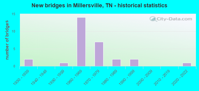
- New bridges - historical statistics
- 21930-1939
- 11950-1959
- 141960-1969
- 71970-1979
- 21980-1989
- 21990-1999
- 12020-2022


- Bridge Condition - Deck
- 75.0%Good
- 12.5%Satisfactory
- 12.5%Fair

- Bridge Condition - Superstructure
- 75.0%Good
- 25.0%Fair

- Bridge Condition - Substructure
- 75.0%Good
- 25.0%Satisfactory

- Bridge Condition - Channel
- 6.7%Very good
- 46.7%Good
- 40.0%Satisfactory
- 6.7%Fair

- Bridge Condition - Culverts
- 14.3%Very good
- 57.1%Good
- 21.4%Satisfactory
- 7.1%Poor
Find on map >> Show street view
Structure Number: 190B3740001, Location: KINGSBURY DR@MELBOURNE DR (Lat: 36.057500, Lng: -86.845167), Route carried "on" structure: City street 359, Year Built: 1970, Status: Open, Structure Length: 1.46m (4.79ft), Average Daily Traffic: 1,090 (year 2022), Truck Traffic: 2%, Average Future Daily Traffic: 1,744 (year 2041), Features Intersected: 0TTER CREEK
Minimum Vertical Clearance: 30+ m (98+ ft), Kilometerpoint: 1.864, Lanes on structure: 2, Owner: City or Municipal Highway Agency, Approaching Roadway Width: 6.1m (20.0ft), Skew: 1 degrees, Material/Design: Concrete continuous, Design/Construction: Culvert, Number Of Spans In Main Unit: 4, Length of Maximum Span: 3.4m (11.2ft), Curb-To-Curb Width: 7.4m (24.3ft), Out-to-Out Width: 8.1m (26.6ft)
Condition: Channel: Satisfactory, Culverts: Good, Operating Rating: 90.0 metric tons, Method Used To Determine Operating Rating: Load Factor (LF), Inventory Rating: 32.4 metric tons, Method Used To Determine Inventory Rating: Load Factor (LF), Structural Evaluation: Better than present minimum criteria, Deck Geometry: Meets minimum limits, Waterway Adequacy: Better than present minimum criteria, Approach Roadway Alignment: Equal to present desirable criteria, Designated Inspection Frequency: Every 24 months, Inspection Date: June 2021, Deck Structure Type: Concrete Cast-file-Place, Wearing Surface/Protective System: Wearing Surface: Bituminous
Find on map >> Show street view
Structure Number: 190B3750001, Location: 1 M E OF SR 11 (Lat: 36.386850, Lng: -86.734750), Route carried "on" structure: City street 375, Year Built: 2021, Status: Open, Structure Length: 0.98m (3.22ft), Average Daily Traffic: 50 (year 2022), Truck Traffic: 2%, Average Future Daily Traffic: 80 (year 2041), Design Load: HL 93, Features Intersected: MANSKER CREEK
Minimum Vertical Clearance: 30+ m (98+ ft), Kilometerpoint: 0.011, Lanes on structure: 2, Owner: City or Municipal Highway Agency, Approaching Roadway Width: 6.1m (20.0ft), Material/Design: Concrete continuous, Design/Construction: Culvert, Number Of Spans In Main Unit: 2, Length of Maximum Span: 4.9m (16.1ft), Curb-To-Curb Width: 5.7m (18.7ft), Out-to-Out Width: 19.8m (65.0ft)
Condition: Channel: Very good, Culverts: Good, Operating Rating: 42.1 metric tons, Method Used To Determine Operating Rating: Assigned ratings based on Load and Resistance Factor Design (LRFD) reported by rating factor (RF) using HL93 loadings, Inventory Rating: 32.4 metric tons, Method Used To Determine Inventory Rating: Assigned ratings based on Load and Resistance Factor Design (LRFD) reported by rating factor (RF) using HL93 loadings, Structural Evaluation: Better than present minimum criteria, Deck Geometry: Meets minimum limits, Waterway Adequacy: Equal to present desirable criteria, Approach Roadway Alignment: Equal to present desirable criteria, Designated Inspection Frequency: Every 24 months, Inspection Date: August 2021
Find on map >> Show street view
Structure Number: 740A2880001, Location: 3.4 MI SW JCT I65&SR76 (Lat: 36.429867, Lng: -86.713600), Route carried "on" structure: County highway 288, Year Built: 1975, Status: Open, Structure Length: 1.01m (3.31ft), Average Daily Traffic: 190 (year 2022), Truck Traffic: 2%, Average Future Daily Traffic: 304 (year 2040), Design Load: H 20, Features Intersected: SULPHUR FORK CREEK
Minimum Vertical Clearance: 30+ m (98+ ft), Kilometerpoint: 2.303, Lanes on structure: 2, Owner: County Highway Agency, Approaching Roadway Width: 4.6m (15.1ft), Material/Design: Concrete continuous, Design/Construction: Culvert, Number Of Spans In Main Unit: 2, Length of Maximum Span: 4.6m (15.1ft), Curb-To-Curb Width: 7.4m (24.3ft), Out-to-Out Width: 8.0m (26.2ft)
Condition: Channel: Satisfactory, Culverts: Good, Operating Rating: 45.0 metric tons, Method Used To Determine Operating Rating: Load Factor (LF), Inventory Rating: 28.8 metric tons, Method Used To Determine Inventory Rating: Load Factor (LF), Structural Evaluation: Better than present minimum criteria, Deck Geometry: Somewhat better than minimum adequacy, Waterway Adequacy: Better than present minimum criteria, Approach Roadway Alignment: Equal to present desirable criteria, Designated Inspection Frequency: Every 24 months, Inspection Date: April 2020, Deck Structure Type: Concrete Cast-file-Place, Wearing Surface/Protective System: Wearing Surface: Monolithic Concrete
Find on map >> Show street view
Structure Number: 74I00650001, Location: OVER BETHEL ROAD (Lat: 36.417417, Lng: -86.717233), Route carried "on" structure: State highway 257, Year Built: 1969, Status: Open, Structure Length: 6.58m (21.59ft), Average Daily Traffic: 3,512 (year 2020), Truck Traffic: 4%, Average Future Daily Traffic: 6,016 (year 2040), Design Load: HS 20, Features Intersected: BETHEL RD / I65 NBL
Minimum Vertical Clearance: 30+ m (98+ ft), Kilometerpoint: 1.593, Lanes on structure: 2, Lanes under structure: 3, Owner: State Highway Agency, Approaching Roadway Width: 14.6m (47.9ft), Material/Design: Concrete continuous, Design/Construction: Box Beam or Girders - Multiple, Number Of Spans In Main Unit: 3, Length of Maximum Span: 38.7m (127.0ft), Curb-To-Curb Width: 14.6m (47.9ft), Out-to-Out Width: 15.2m (49.9ft)
Condition: Deck: Satisfactory, Superstructure: Good, Substructure: Good, Operating Rating: 43.7 metric tons, Method Used To Determine Operating Rating: Load and Resistance Factor Rating (LRFR) rating reported by rating factor(RF) method using HL-93 loadings, Inventory Rating: 34.7 metric tons, Method Used To Determine Inventory Rating: Load and Resistance Factor Rating (LRFR) rating reported by rating factor(RF) method using HL-93 loadings, Structural Evaluation: Better than present minimum criteria, Deck Geometry: Superior to present desirable criteria, Underclear: Somewhat better than minimum adequacy, Approach Roadway Alignment: Equal to present desirable criteria, Designated Inspection Frequency: Every 24 months, Inspection Date: March 2020, Deck Structure Type: Concrete Cast-file-Place, Wearing Surface/Protective System: Wearing Surface: Bituminous
Find on map >> Show street view
Structure Number: 74I00650003, Location: .3 M NE ROB SUMN CO LI (Lat: 36.417667, Lng: -86.718700), Route carried "on" structure: Interstate 65, Year Built: 1972, Status: Open, Structure Length: 5.30m (17.39ft), Average Daily Traffic: 56,491 (year 2020), Truck Traffic: 46%, Average Future Daily Traffic: 90,386 (year 2041), Design Load: HS 20, Features Intersected: I65 LL / BETHEL RD
Minimum Vertical Clearance: 30+ m (98+ ft), Kilometerpoint: 0.322, Lanes on structure: 2, Lanes under structure: 2, Base Highway Network: Yes, Owner: State Highway Agency, Approaching Roadway Width: 11.6m (38.1ft), Skew: 10 degrees, Material/Design: Concrete continuous, Design/Construction: Tee Beam, Number Of Spans In Main Unit: 3, Length of Maximum Span: 26.5m (86.9ft), Curb-To-Curb Width: 12.8m (42.0ft), Out-to-Out Width: 13.4m (44.0ft)
Condition: Deck: Good, Superstructure: Fair, Substructure: Good, Operating Rating: 37.3 metric tons, Method Used To Determine Operating Rating: Load and Resistance Factor Rating (LRFR) rating reported by rating factor(RF) method using HL-93 loadings, Inventory Rating: 26.9 metric tons, Method Used To Determine Inventory Rating: Load and Resistance Factor Rating (LRFR) rating reported by rating factor(RF) method using HL-93 loadings, Structural Evaluation: Somewhat better than minimum adequacy, Deck Geometry: Somewhat better than minimum adequacy, Underclear: Equal to present minimum criteria, Approach Roadway Alignment: Equal to present desirable criteria, Length Of Structure Improvement: 5.30m (17.39ft), Designated Inspection Frequency: Every 24 months, Inspection Date: March 2020, Bridge Improvement Cost: $1,386,000, Roadway Improvement Cost: $139,000, Total Project Cost: $2,080,000 ( Estimate for 2021), Deck Structure Type: Concrete Cast-file-Place, Wearing Surface/Protective System: Wearing Surface: Bituminous
Find on map >> Show street view
Structure Number: 74I00650005, Location: 1.5 MI NE JCT I65&SR257 (Lat: 36.435667, Lng: -86.706633), Route carried "on" structure: County highway 1021, Year Built: 1969, Status: Open, Structure Length: 9.51m (31.20ft), Average Daily Traffic: 1,037 (year 2020), Truck Traffic: 5%, Average Future Daily Traffic: 1,659 (year 2041), Design Load: HS 20, Features Intersected: NEW HALL RD (1021) / I65
Minimum Vertical Clearance: 30+ m (98+ ft), Kilometerpoint: 1.786, Lanes on structure: 2, Lanes under structure: 4, Owner: State Highway Agency, Approaching Roadway Width: 8.5m (27.9ft), Skew: 2 degrees, Material/Design: Concrete continuous, Design/Construction: Box Beam or Girders - Multiple, Number Of Spans In Main Unit: 4, Length of Maximum Span: 34.7m (113.8ft), Curb-To-Curb Width: 8.7m (28.5ft), Out-to-Out Width: 9.8m (32.2ft)
Condition: Deck: Good, Superstructure: Good, Substructure: Good, Operating Rating: 53.1 metric tons, Method Used To Determine Operating Rating: Load and Resistance Factor Rating (LRFR) rating reported by rating factor(RF) method using HL-93 loadings, Inventory Rating: 39.5 metric tons, Method Used To Determine Inventory Rating: Load and Resistance Factor Rating (LRFR) rating reported by rating factor(RF) method using HL-93 loadings, Structural Evaluation: Better than present minimum criteria, Deck Geometry: Somewhat better than minimum adequacy, Underclear: Equal to present minimum criteria, Approach Roadway Alignment: Equal to present desirable criteria, Designated Inspection Frequency: Every 24 months, Inspection Date: March 2020, Deck Structure Type: Concrete Cast-file-Place, Wearing Surface/Protective System: Wearing Surface: Bituminous
Find on map >> Show street view
Structure Number: 83020480001, Location: 2.7 MI NW JCT SR174&SR258 (Lat: 36.415817, Lng: -86.650867), Route carried "on" structure: County highway 2048, Year Built: 1984, Status: Open, Structure Length: 1.52m (4.99ft), Average Daily Traffic: 670 (year 2020), Truck Traffic: 4%, Average Future Daily Traffic: 1,248 (year 2041), Design Load: HS 20, Features Intersected: DRAKES CREEK
Minimum Vertical Clearance: 30+ m (98+ ft), Kilometerpoint: 0.064, Lanes on structure: 2, Owner: County Highway Agency, Approaching Roadway Width: 6.1m (20.0ft), Skew: 3 degrees, Material/Design: Concrete continuous, Design/Construction: Culvert, Number Of Spans In Main Unit: 4, Length of Maximum Span: 3.0m (9.8ft), Curb-To-Curb Width: 6.7m (22.0ft), Out-to-Out Width: 7.8m (25.6ft)
Condition: Channel: Satisfactory, Culverts: Satisfactory, Operating Rating: 38.9 metric tons, Method Used To Determine Operating Rating: Load Factor (LF), Inventory Rating: 22.7 metric tons, Method Used To Determine Inventory Rating: Load Factor (LF), Structural Evaluation: Equal to present minimum criteria, Deck Geometry: Meets minimum limits, Waterway Adequacy: Somewhat better than minimum adequacy, Approach Roadway Alignment: Equal to present desirable criteria, Length Of Structure Improvement: 1.52m (4.99ft), Designated Inspection Frequency: Every 24 months, Inspection Date: January 2021, Bridge Improvement Cost: $238,000, Roadway Improvement Cost: $24,000, Total Project Cost: $358,000 ( Estimate for 2021), Deck Structure Type: Concrete Cast-file-Place, Wearing Surface/Protective System: Wearing Surface: Monolithic Concrete
Find on map >> Show street view
Structure Number: 83020480003, Location: 4.1 MI NW JCT SR174&AR258 (Lat: 36.415367, Lng: -86.665617), Route carried "on" structure: County highway 2048, Year Built: 1955, Status: Open, Structure Length: 1.01m (3.31ft), Average Daily Traffic: 670 (year 2020), Truck Traffic: 4%, Average Future Daily Traffic: 1,248 (year 2041), Design Load: H 15, Features Intersected: BRANCH
Minimum Vertical Clearance: 30+ m (98+ ft), Kilometerpoint: 1.400, Lanes on structure: 2, Owner: County Highway Agency, Approaching Roadway Width: 5.5m (18.0ft), Skew: 4 degrees, Material/Design: Concrete continuous, Design/Construction: Culvert, Number Of Spans In Main Unit: 2, Length of Maximum Span: 3.0m (9.8ft), Curb-To-Curb Width: 6.4m (21.0ft), Out-to-Out Width: 6.9m (22.6ft)
Condition: Channel: Fair, Culverts: Satisfactory, Operating Rating: 32.4 metric tons, Method Used To Determine Operating Rating: Load Factor (LF), Inventory Rating: 24.3 metric tons, Method Used To Determine Inventory Rating: Load Factor (LF), Structural Evaluation: Equal to present minimum criteria, Deck Geometry: High priority of corrective action, Waterway Adequacy: Equal to present minimum criteria, Approach Roadway Alignment: Equal to present minimum criteria, Length Of Structure Improvement: 1.01m (3.31ft), Designated Inspection Frequency: Every 24 months, Inspection Date: January 2021, Bridge Improvement Cost: $89,000, Roadway Improvement Cost: $9,000, Total Project Cost: $134,000 ( Estimate for 2021), Deck Structure Type: Concrete Cast-file-Place, Wearing Surface/Protective System: Wearing Surface: Bituminous
Find on map >> Show street view
Structure Number: 830A0220001, Location: .7 MI NE JCT SR 11& SR 41 (Lat: 36.351700, Lng: -86.712717), Route carried "on" structure: City street 22, Year Built: 1960, Status: Open, Structure Length: 1.01m (3.31ft), Average Daily Traffic: 350 (year 2022), Truck Traffic: 6%, Average Future Daily Traffic: 560 (year 2041), Design Load: H 20, Features Intersected: SLATER'S CREEK
Minimum Vertical Clearance: 30+ m (98+ ft), Kilometerpoint: 0.204, Lanes on structure: 2, Owner: City or Municipal Highway Agency, Approaching Roadway Width: 7.9m (25.9ft), Material/Design: Concrete continuous, Design/Construction: Culvert, Number Of Spans In Main Unit: 2, Length of Maximum Span: 4.6m (15.1ft), Curb-To-Curb Width: 7.3m (24.0ft), Out-to-Out Width: 8.0m (26.2ft)
Condition: Channel: Satisfactory, Culverts: Good, Operating Rating: 34.0 metric tons, Method Used To Determine Operating Rating: Load Factor (LF), Inventory Rating: 24.3 metric tons, Method Used To Determine Inventory Rating: Load Factor (LF), Structural Evaluation: Equal to present minimum criteria, Deck Geometry: Somewhat better than minimum adequacy, Waterway Adequacy: Somewhat better than minimum adequacy, Approach Roadway Alignment: Equal to present desirable criteria, Length Of Structure Improvement: 1.01m (3.31ft), Designated Inspection Frequency: Every 24 months, Inspection Date: January 2021, Bridge Improvement Cost: $161,000, Roadway Improvement Cost: $17,000, Total Project Cost: $242,000 ( Estimate for 2021), Wearing Surface/Protective System: Wearing Surface: Bituminous
Find on map >> Show street view
Structure Number: 830A0230001, Location: 2.3 MI NW JCT I65&SR174 (Lat: 36.359550, Lng: -86.712467), Route carried "on" structure: City street 23, Year Built: 1990, Status: Open, Structure Length: 1.46m (4.79ft), Average Daily Traffic: 120 (year 2022), Truck Traffic: 7%, Average Future Daily Traffic: 192 (year 2041), Design Load: HS 20, Features Intersected: SLATER'S CREEK
Minimum Vertical Clearance: 30+ m (98+ ft), Kilometerpoint: 0.000, Lanes on structure: 2, Owner: City or Municipal Highway Agency, Approaching Roadway Width: 3.0m (9.8ft), Material/Design: Concrete continuous, Design/Construction: Culvert, Number Of Spans In Main Unit: 3, Length of Maximum Span: 4.6m (15.1ft), Curb-To-Curb Width: 6.7m (22.0ft), Out-to-Out Width: 8.4m (27.6ft)
Condition: Channel: Good, Culverts: Good, Operating Rating: 89.1 metric tons, Method Used To Determine Operating Rating: Load Factor (LF), Inventory Rating: 32.4 metric tons, Method Used To Determine Inventory Rating: Load Factor (LF), Structural Evaluation: Better than present minimum criteria, Deck Geometry: Meets minimum limits, Waterway Adequacy: Somewhat better than minimum adequacy, Approach Roadway Alignment: Equal to present desirable criteria, Length Of Structure Improvement: 1.46m (4.79ft), Designated Inspection Frequency: Every 24 months, Inspection Date: Febuary 2021, Bridge Improvement Cost: $221,000, Roadway Improvement Cost: $23,000, Total Project Cost: $332,000 ( Estimate for 2021), Deck Structure Type: Concrete Cast-file-Place, Wearing Surface/Protective System: Wearing Surface: Monolithic Concrete, Deck Protection: Epoxy Coated Reinforcing
Find on map >> Show street view
Structure Number: 830B2180001, Location: 2.5 MI N JCT SR11 & SR41 (Lat: 36.381000, Lng: -86.713233), Route carried "on" structure: City street 5433, Year Built: 1985, Status: Open, Structure Length: 2.04m (6.69ft), Average Daily Traffic: 2,129 (year 2020), Truck Traffic: 4%, Average Future Daily Traffic: 3,406 (year 2041), Design Load: HS 20, Features Intersected: SLATERS CREEK, Facility Carried by Structure: NFA B218
Minimum Vertical Clearance: 30+ m (98+ ft), Kilometerpoint: 4.426, Lanes on structure: 2, Owner: City or Municipal Highway Agency, Approaching Roadway Width: 5.8m (19.0ft), Skew: 3 degrees, Material/Design: Concrete continuous, Design/Construction: Culvert, Number Of Spans In Main Unit: 3, Length of Maximum Span: 5.5m (18.0ft), Curb-To-Curb Width: 7.4m (24.3ft), Out-to-Out Width: 8.7m (28.5ft)
Condition: Channel: Satisfactory, Culverts: Very good, Operating Rating: 42.3 metric tons, Method Used To Determine Operating Rating: Load Factor (LF), Inventory Rating: 26.1 metric tons, Method Used To Determine Inventory Rating: Load Factor (LF), Structural Evaluation: Equal to present minimum criteria, Deck Geometry: High priority of replacement, Waterway Adequacy: Somewhat better than minimum adequacy, Approach Roadway Alignment: Equal to present desirable criteria, Length Of Structure Improvement: 2.04m (6.69ft), Designated Inspection Frequency: Every 24 months, Inspection Date: Febuary 2021, Bridge Improvement Cost: $208,000, Roadway Improvement Cost: $21,000, Total Project Cost: $313,000 ( Estimate for 2021), Deck Structure Type: Concrete Cast-file-Place, Wearing Surface/Protective System: Wearing Surface: Bituminous
Find on map >> Show street view
Structure Number: 830B4420001, Location: 2 M NE JCT I65 & SR 41 (Lat: 36.357033, Lng: -86.712267), Route carried "on" structure: City street 442, Year Built: 1993, Status: Open, Structure Length: 1.49m (4.89ft), Average Daily Traffic: 50 (year 2022), Truck Traffic: 2%, Average Future Daily Traffic: 80 (year 2041), Design Load: HS 20, Features Intersected: SLATERS CREEK
Minimum Vertical Clearance: 30+ m (98+ ft), Kilometerpoint: 0.089, Lanes on structure: 2, Owner: City or Municipal Highway Agency, Approaching Roadway Width: 4.9m (16.1ft), Material/Design: Concrete continuous, Design/Construction: Culvert, Number Of Spans In Main Unit: 3, Length of Maximum Span: 4.6m (15.1ft), Curb-To-Curb Width: 7.3m (24.0ft), Out-to-Out Width: 9.0m (29.5ft)
Condition: Channel: Good, Culverts: Very good, Operating Rating: 84.2 metric tons, Method Used To Determine Operating Rating: Load Factor (LF), Inventory Rating: 32.4 metric tons, Method Used To Determine Inventory Rating: Load Factor (LF), Structural Evaluation: Equal to present desirable criteria, Deck Geometry: Equal to present minimum criteria, Waterway Adequacy: Somewhat better than minimum adequacy, Approach Roadway Alignment: Equal to present minimum criteria, Designated Inspection Frequency: Every 24 months, Inspection Date: Febuary 2021, Deck Structure Type: Concrete Cast-file-Place, Wearing Surface/Protective System: Wearing Surface: Monolithic Concrete, Deck Protection: Epoxy Coated Reinforcing
Find on map >> Show street view
Structure Number: 83I00650001, Location: .9 M N DAVIDSON CO LINE (Lat: 36.345500, Lng: -86.715500), Route carried "on" structure: Interstate 65, Year Built: 1969, Status: Open, Structure Length: 2.29m (7.51ft), Average Daily Traffic: 98,206 (year 2020), Truck Traffic: 13%, Average Future Daily Traffic: 172,864 (year 2040), Design Load: HS 20, Features Intersected: SLATORS CREEK
Minimum Vertical Clearance: 30+ m (98+ ft), Kilometerpoint: 1.432, Lanes on structure: 4, Base Highway Network: Yes, Owner: State Highway Agency, Approaching Roadway Width: 41.5m (136.2ft), Skew: 14 degrees, Material/Design: Concrete continuous, Design/Construction: Culvert, Number Of Spans In Main Unit: 4, Length of Maximum Span: 3.7m (12.1ft)
Condition: Channel: Good, Culverts: Satisfactory, Operating Rating: 54.0 metric tons, Method Used To Determine Operating Rating: Field evaluation and documented engineering judgment, Inventory Rating: 32.4 metric tons, Method Used To Determine Inventory Rating: Field evaluation and documented engineering judgment, Structural Evaluation: Equal to present minimum criteria, Waterway Adequacy: Better than present minimum criteria, Approach Roadway Alignment: Equal to present desirable criteria, Length Of Structure Improvement: 2.29m (7.51ft), Designated Inspection Frequency: Every 24 months, Inspection Date: August 2020, Bridge Improvement Cost: $718,000, Roadway Improvement Cost: $72,000, Total Project Cost: $1,078,000 ( Estimate for 2020)
Find on map >> Show street view
Structure Number: 83I00650005, Location: 2.5 M N DAVIDSON CO LINE (Lat: 36.366533, Lng: -86.714300), Route carried "on" structure: Interstate 65, Year Built: 1969, Status: Open, Structure Length: 3.72m (12.20ft), Average Daily Traffic: 56,491 (year 2020), Truck Traffic: 46%, Average Future Daily Traffic: 90,386 (year 2041), Design Load: HS 20, Features Intersected: I65 / CARTWRIGHT CIRCLE
Minimum Vertical Clearance: 30+ m (98+ ft), Kilometerpoint: 3.959, Lanes on structure: 2, Lanes under structure: 2, Base Highway Network: Yes, Owner: State Highway Agency, Approaching Roadway Width: 12.8m (42.0ft), Skew: 1 degrees, Material/Design: Concrete continuous, Design/Construction: Tee Beam, Number Of Spans In Main Unit: 3, Length of Maximum Span: 14.9m (48.9ft), Curb-To-Curb Width: 12.8m (42.0ft), Out-to-Out Width: 13.4m (44.0ft)
Condition: Deck: Good, Superstructure: Good, Substructure: Satisfactory, Operating Rating: 33.0 metric tons, Method Used To Determine Operating Rating: Load and Resistance Factor Rating (LRFR) rating reported by rating factor(RF) method using HL-93 loadings, Inventory Rating: 24.6 metric tons, Method Used To Determine Inventory Rating: Load and Resistance Factor Rating (LRFR) rating reported by rating factor(RF) method using HL-93 loadings, Structural Evaluation: Equal to present minimum criteria, Deck Geometry: Equal to present desirable criteria, Underclear: Equal to present desirable criteria, Approach Roadway Alignment: Equal to present desirable criteria, Length Of Structure Improvement: 3.72m (12.20ft), Designated Inspection Frequency: Every 24 months, Inspection Date: August 2020, Bridge Improvement Cost: $753,000, Roadway Improvement Cost: $76,000, Total Project Cost: $1,130,000 ( Estimate for 2021), Deck Structure Type: Concrete Cast-file-Place, Wearing Surface/Protective System: Wearing Surface: Bituminous
Find on map >> Show street view
Structure Number: 83I00650006, Location: 2.5 M N DAVIDSON CO LINE (Lat: 36.365833, Lng: -86.714550), Route carried "on" structure: Interstate 65, Year Built: 1969, Status: Open, Structure Length: 3.72m (12.20ft), Average Daily Traffic: 56,491 (year 2020), Truck Traffic: 46%, Average Future Daily Traffic: 90,386 (year 2041), Design Load: HS 20+Mod, Features Intersected: I65 / CARTWRIGHT CIRCLE
Minimum Vertical Clearance: 30+ m (98+ ft), Kilometerpoint: 3.959, Lanes on structure: 2, Lanes under structure: 2, Base Highway Network: Yes, Owner: State Highway Agency, Approaching Roadway Width: 12.8m (42.0ft), Skew: 11 degrees, Material/Design: Concrete continuous, Design/Construction: Tee Beam, Number Of Spans In Main Unit: 3, Length of Maximum Span: 14.9m (48.9ft), Curb-To-Curb Width: 12.8m (42.0ft), Out-to-Out Width: 13.4m (44.0ft)
Condition: Deck: Good, Superstructure: Good, Substructure: Good, Operating Rating: 33.0 metric tons, Method Used To Determine Operating Rating: Load and Resistance Factor Rating (LRFR) rating reported by rating factor(RF) method using HL-93 loadings, Inventory Rating: 24.6 metric tons, Method Used To Determine Inventory Rating: Load and Resistance Factor Rating (LRFR) rating reported by rating factor(RF) method using HL-93 loadings, Structural Evaluation: Equal to present minimum criteria, Deck Geometry: Equal to present desirable criteria, Underclear: Equal to present minimum criteria, Approach Roadway Alignment: Equal to present desirable criteria, Length Of Structure Improvement: 4.65m (15.26ft), Designated Inspection Frequency: Every 24 months, Inspection Date: August 2020, Bridge Improvement Cost: $1,336,000, Roadway Improvement Cost: $134,000, Total Project Cost: $2,005,000 ( Estimate for 2021), Deck Structure Type: Concrete Cast-file-Place, Wearing Surface/Protective System: Wearing Surface: Bituminous
Find on map >> Show street view
Structure Number: 83I00650007, Location: 3.5 M N DAVIDSON CO LINE (Lat: 36.380833, Lng: -86.713917), Route carried "on" structure: Interstate 65, Year Built: 1972, Status: Open, Structure Length: 3.63m (11.91ft), Average Daily Traffic: 56,491 (year 2020), Truck Traffic: 46%, Average Future Daily Traffic: 94,752 (year 2040), Design Load: HS 20+Mod, Features Intersected: I65 / WILLIAMSON RD. B21
Minimum Vertical Clearance: 30+ m (98+ ft), Kilometerpoint: 5.633, Lanes on structure: 2, Lanes under structure: 2, Base Highway Network: Yes, Owner: State Highway Agency, Approaching Roadway Width: 12.8m (42.0ft), Skew: 11 degrees, Material/Design: Concrete continuous, Design/Construction: Tee Beam, Number Of Spans In Main Unit: 3, Length of Maximum Span: 17.4m (57.1ft), Curb-To-Curb Width: 12.8m (42.0ft), Out-to-Out Width: 13.4m (44.0ft)
Condition: Deck: Good, Superstructure: Good, Substructure: Good, Operating Rating: 43.4 metric tons, Method Used To Determine Operating Rating: Load Factor (LF), Inventory Rating: 26.9 metric tons, Method Used To Determine Inventory Rating: Load Factor (LF), Structural Evaluation: Equal to present minimum criteria, Deck Geometry: Equal to present desirable criteria, Underclear: Meets minimum limits, Approach Roadway Alignment: Equal to present desirable criteria, Length Of Structure Improvement: 3.63m (11.91ft), Designated Inspection Frequency: Every 24 months, Inspection Date: August 2020, Bridge Improvement Cost: $812,000, Roadway Improvement Cost: $82,000, Total Project Cost: $1,219,000 ( Estimate for 2020), Deck Structure Type: Concrete Cast-file-Place, Wearing Surface/Protective System: Wearing Surface: Bituminous
Find on map >> Show street view
Structure Number: 83I00650008, Location: 3.5 M N DAVIDSON CO LINE (Lat: 36.381419, Lng: -86.714756), Route carried "on" structure: Interstate 65, Year Built: 1972, Status: Open, Structure Length: 3.63m (11.91ft), Average Daily Traffic: 56,491 (year 2020), Truck Traffic: 46%, Average Future Daily Traffic: 94,752 (year 2040), Design Load: HS 20+Mod, Features Intersected: I65 / WILLIAMSON RD. B21
Minimum Vertical Clearance: 30+ m (98+ ft), Kilometerpoint: 5.633, Lanes on structure: 2, Lanes under structure: 2, Base Highway Network: Yes, Owner: State Highway Agency, Approaching Roadway Width: 12.8m (42.0ft), Skew: 13 degrees, Material/Design: Concrete continuous, Design/Construction: Tee Beam, Number Of Spans In Main Unit: 3, Length of Maximum Span: 17.4m (57.1ft), Curb-To-Curb Width: 12.8m (42.0ft), Out-to-Out Width: 13.4m (44.0ft)
Condition: Deck: Good, Superstructure: Good, Substructure: Good, Operating Rating: 43.4 metric tons, Method Used To Determine Operating Rating: Load Factor (LF), Inventory Rating: 26.0 metric tons, Method Used To Determine Inventory Rating: Load Factor (LF), Structural Evaluation: Equal to present minimum criteria, Deck Geometry: Equal to present desirable criteria, Underclear: Meets minimum limits, Approach Roadway Alignment: Equal to present desirable criteria, Length Of Structure Improvement: 3.63m (11.91ft), Designated Inspection Frequency: Every 24 months, Inspection Date: August 2020, Bridge Improvement Cost: $125,000, Roadway Improvement Cost: $13,000, Total Project Cost: $188,000 ( Estimate for 2020), Deck Structure Type: Concrete Cast-file-Place, Wearing Surface/Protective System: Wearing Surface: Bituminous
Find on map >> Show street view
Structure Number: 83I00650009, Location: 1.9 M S JCT I65&SR257 (Lat: 36.389500, Lng: -86.716000), Route carried "on" structure: Interstate 65, Year Built: 1972, Status: Open, Structure Length: 1.16m (3.81ft), Average Daily Traffic: 56,491 (year 2020), Truck Traffic: 46%, Average Future Daily Traffic: 94,752 (year 2040), Design Load: HS 20+Mod, Features Intersected: BRANCH
Minimum Vertical Clearance: 30+ m (98+ ft), Kilometerpoint: 6.550, Lanes on structure: 4, Base Highway Network: Yes, Owner: State Highway Agency, Approaching Roadway Width: 42.7m (140.1ft), Skew: 13 degrees, Material/Design: Concrete continuous, Design/Construction: Culvert, Number Of Spans In Main Unit: 3, Length of Maximum Span: 3.4m (11.2ft)
Condition: Channel: Good, Culverts: Good, Operating Rating: 89.1 metric tons, Method Used To Determine Operating Rating: Load Factor (LF), Inventory Rating: 32.4 metric tons, Method Used To Determine Inventory Rating: Load Factor (LF), Structural Evaluation: Better than present minimum criteria, Waterway Adequacy: Equal to present minimum criteria, Approach Roadway Alignment: Equal to present desirable criteria, Length Of Structure Improvement: 1.16m (3.81ft), Designated Inspection Frequency: Every 24 months, Inspection Date: August 2020, Bridge Improvement Cost: $385,000, Roadway Improvement Cost: $39,000, Total Project Cost: $578,000 ( Estimate for 2020)
Find on map >> Show street view
Structure Number: 83I00650011, Location: 1.6 M S JCT I65&SR257 (Lat: 36.393683, Lng: -86.716767), Route carried "on" structure: Interstate 65, Year Built: 1972, Status: Open, Structure Length: 1.19m (3.90ft), Average Daily Traffic: 56,491 (year 2020), Truck Traffic: 46%, Average Future Daily Traffic: 94,752 (year 2040), Design Load: HS 20+Mod, Features Intersected: BRANCH
Minimum Vertical Clearance: 30+ m (98+ ft), Kilometerpoint: 7.097, Lanes on structure: 4, Base Highway Network: Yes, Owner: State Highway Agency, Approaching Roadway Width: 42.7m (140.1ft), Skew: 13 degrees, Material/Design: Concrete continuous, Design/Construction: Culvert, Number Of Spans In Main Unit: 3, Length of Maximum Span: 3.0m (9.8ft)
Condition: Channel: Good, Culverts: Good, Operating Rating: 89.1 metric tons, Method Used To Determine Operating Rating: Load Factor (LF), Inventory Rating: 32.4 metric tons, Method Used To Determine Inventory Rating: Load Factor (LF), Structural Evaluation: Better than present minimum criteria, Waterway Adequacy: Equal to present minimum criteria, Approach Roadway Alignment: Equal to present desirable criteria, Length Of Structure Improvement: 1.19m (3.90ft), Designated Inspection Frequency: Every 24 months, Inspection Date: August 2020, Bridge Improvement Cost: $393,000, Roadway Improvement Cost: $40,000, Total Project Cost: $590,000 ( Estimate for 2020)
Find on map >> Show street view
Structure Number: 83S61270007, Location: 2 M NE JCT SR41&SR257 (Lat: 36.425350, Lng: -86.659200), Route carried "on" structure: State highway 258, Year Built: 1960, Status: Open, Structure Length: 1.43m (4.69ft), Average Daily Traffic: 5,598 (year 2020), Truck Traffic: 4%, Average Future Daily Traffic: 12,144 (year 2040), Design Load: H 15, Features Intersected: BRANCH
Minimum Vertical Clearance: 30+ m (98+ ft), Kilometerpoint: 15.997, Lanes on structure: 2, Owner: State Highway Agency, Approaching Roadway Width: 7.9m (25.9ft), Skew: 4 degrees, Material/Design: Concrete continuous, Design/Construction: Culvert, Number Of Spans In Main Unit: 3, Length of Maximum Span: 3.0m (9.8ft)
Condition: Channel: Good, Culverts: Good, Operating Rating: 54.1 metric tons, Method Used To Determine Operating Rating: Load Factor (LF), Inventory Rating: 24.3 metric tons, Method Used To Determine Inventory Rating: Load Factor (LF), Structural Evaluation: Equal to present minimum criteria, Waterway Adequacy: Somewhat better than minimum adequacy, Approach Roadway Alignment: Equal to present minimum criteria, Designated Inspection Frequency: Every 24 months, Inspection Date: September 2020
Find on map >> Show street view
Structure Number: 83SR0410001, Location: 1.6 M NE JCT SR41&I65 (Lat: 36.369983, Lng: -86.710300), Route carried "on" structure: US 31, Year Built: 1939, Status: Open, Structure Length: 2.62m (8.60ft), Average Daily Traffic: 9,591 (year 2020), Truck Traffic: 9%, Average Future Daily Traffic: 16,848 (year 2040), Design Load: H 15, Features Intersected: STATER CREEK, Facility Carried by Structure: FAS 41
Minimum Vertical Clearance: 30+ m (98+ ft), Kilometerpoint: 3.154, Lanes on structure: 2, Base Highway Network: Yes, Owner: State Highway Agency, Approaching Roadway Width: 12.2m (40.0ft), Material/Design: Concrete, Design/Construction: Tee Beam, Number Of Spans In Main Unit: 3, Length of Maximum Span: 8.8m (28.9ft), Curb or Sidewalk Widths: Left: 1.5m (4.9ft), Right: 1.5m (4.9ft), Curb-To-Curb Width: 12.2m (40.0ft), Out-to-Out Width: 15.8m (51.8ft)
Condition: Deck: Fair, Superstructure: Fair, Substructure: Satisfactory, Channel: Satisfactory, Operating Rating: 43.2 metric tons, Method Used To Determine Operating Rating: Load Factor (LF), Inventory Rating: 26.1 metric tons, Method Used To Determine Inventory Rating: Load Factor (LF), Structural Evaluation: Somewhat better than minimum adequacy, Deck Geometry: Somewhat better than minimum adequacy, Waterway Adequacy: Better than present minimum criteria, Approach Roadway Alignment: Equal to present desirable criteria, Length Of Structure Improvement: 2.62m (8.60ft), Designated Inspection Frequency: Every 24 months, Inspection Date: August 2020, Bridge Improvement Cost: $661,000, Roadway Improvement Cost: $67,000, Total Project Cost: $992,000 ( Estimate for 2020), Deck Structure Type: Concrete Cast-file-Place, Wearing Surface/Protective System: Wearing Surface: Bituminous
Find on map >> Show street view
Structure Number: 83SR0410003, Location: 1.8 M NE JCT SR41&I65 (Lat: 36.372967, Lng: -86.708950), Route carried "on" structure: US 31, Year Built: 1939, Status: Open, Structure Length: 1.58m (5.18ft), Average Daily Traffic: 9,591 (year 2020), Truck Traffic: 9%, Average Future Daily Traffic: 15,346 (year 2041), Design Load: H 15, Features Intersected: RIGHT FORK SLATERS CREEK, Facility Carried by Structure: FAS 41
Minimum Vertical Clearance: 30+ m (98+ ft), Kilometerpoint: 3.492, Lanes on structure: 2, Base Highway Network: Yes, Owner: State Highway Agency, Approaching Roadway Width: 12.2m (40.0ft), Skew: 5 degrees, Material/Design: Concrete continuous, Design/Construction: Culvert, Number Of Spans In Main Unit: 3, Length of Maximum Span: 3.0m (9.8ft), Curb or Sidewalk Widths: Left: 1.5m (4.9ft), Right: 1.5m (4.9ft), Curb-To-Curb Width: 12.2m (40.0ft), Out-to-Out Width: 15.8m (51.8ft)
Condition: Channel: Good, Culverts: Poor, Operating Rating: 36.0 metric tons, Method Used To Determine Operating Rating: Field evaluation and documented engineering judgment, Inventory Rating: 24.3 metric tons, Method Used To Determine Inventory Rating: Field evaluation and documented engineering judgment, Structural Evaluation: Meets minimum limits, Deck Geometry: Somewhat better than minimum adequacy, Waterway Adequacy: Somewhat better than minimum adequacy, Approach Roadway Alignment: Equal to present desirable criteria, Length Of Structure Improvement: 1.58m (5.18ft), Designated Inspection Frequency: Every 24 months, Inspection Date: August 2020, Bridge Improvement Cost: $399,000, Roadway Improvement Cost: $40,000, Total Project Cost: $599,000 ( Estimate for 2021), Deck Structure Type: Concrete Cast-file-Place, Wearing Surface/Protective System: Wearing Surface: Bituminous
Find on map >> Show street view
Structure Number: 74I00650001, Location: NEAR WHITE HOUSE TENN. (Lat: 36.416667, Lng: -86.716667), Route carried "under" structure: Interstate 65, Year Built: 1969, Structure Length: 0. m, Average Daily Traffic: 56,491 (year 2020), Truck Traffic: 46%, Features Intersected: BETHEL RD / I65 NBL, Facility Carried by Structure: FAS 257
Minimum Vertical Clearance: 4.96m (16.27ft), Kilometerpoint: 0.338, Lanes on structure: 2, Lanes under structure: 3, Material/Design: Concrete continuous, Design/Construction: Box Beam or Girders - Multiple, Length of Maximum Span: 38.7m (127.0ft)
Find on map >> Show street view
Structure Number: 74I00650003, Location: .15 M NE DAVIDSON CO LINE (Lat: 36.417667, Lng: -86.718700), Route carried "under" structure: State highway 257, Year Built: 1969, Structure Length: 0. m, Average Daily Traffic: 4,574 (year 2020), Truck Traffic: 4%, Features Intersected: I65 LL / BETHEL RD., Facility Carried by Structure: I65
Minimum Vertical Clearance: 4.50m (14.76ft), Kilometerpoint: 1.513, Lanes on structure: 2, Lanes under structure: 2, Material/Design: Concrete continuous, Design/Construction: Tee Beam, Length of Maximum Span: 26.5m (86.9ft)
Find on map >> Show street view
Structure Number: 74I00650005, Location: NEAR WHITEHOUSE TENN. (Lat: 36.435667, Lng: -86.706633), Route carried "under" structure: Interstate 65, Year Built: 1969, Structure Length: 0. m, Average Daily Traffic: 56,153 (year 2020), Truck Traffic: 46%, Features Intersected: NEW HALL RD (1021) / I65, Facility Carried by Structure: NFA 1021 (SA 7416)
Minimum Vertical Clearance: 5.03m (16.50ft), Kilometerpoint: 2.575, Lanes on structure: 2, Lanes under structure: 4, Material/Design: Prestressed concrete continuous, Design/Construction: Box Beam or Girders - Multiple, Length of Maximum Span: 34.7m (113.8ft)
Find on map >> Show street view
Structure Number: 83I00650005, Location: 2.3 MI N JCT SR11 & SR41 (Lat: 36.366533, Lng: -86.713967), Route carried "under" structure: City street 5433, Year Built: 1969, Structure Length: 0. m, Average Daily Traffic: 450 (year 2022), Truck Traffic: 2%, Features Intersected: I65 /CARTWRIGHT CIRCE, Facility Carried by Structure: I65
Minimum Vertical Clearance: 6.05m (19.85ft), Kilometerpoint: 0.274, Lanes on structure: 2, Lanes under structure: 2, Material/Design: Concrete continuous, Design/Construction: Tee Beam, Length of Maximum Span: 17.4m (57.1ft)
Find on map >> Show street view
Structure Number: 83I00650006, Location: 2.3 MI N JCT SR11 & SR41 (Lat: 36.365833, Lng: -86.714550), Route carried "under" structure: City street 5433, Year Built: 1969, Structure Length: 0. m, Average Daily Traffic: 450 (year 2022), Truck Traffic: 2%, Features Intersected: I65 /CARTWRIGHT CIRCE, Facility Carried by Structure: I65
Minimum Vertical Clearance: 5.39m (17.68ft), Kilometerpoint: 0.306, Lanes on structure: 2, Lanes under structure: 2, Material/Design: Concrete continuous, Design/Construction: Tee Beam, Length of Maximum Span: 17.4m (57.1ft)
Find on map >> Show street view
Structure Number: 83I00650007, Location: 2.3 MI N JCT SR11 & SR41 (Lat: 36.380833, Lng: -86.713917), Route carried "under" structure: City street 5433, Year Built: 1969, Structure Length: 0. m, Average Daily Traffic: 2,129 (year 2020), Truck Traffic: 4%, Features Intersected: I65 / WILLIAMSON RD. B21, Facility Carried by Structure: I65
Minimum Vertical Clearance: 4.27m (14.01ft), Kilometerpoint: 4.371, Lanes on structure: 2, Lanes under structure: 2, Material/Design: Concrete continuous, Design/Construction: Tee Beam, Length of Maximum Span: 17.4m (57.1ft)
Find on map >> Show street view
Structure Number: 83I00650008, Location: 2.3 MI N JCT SR11 & SR41 (Lat: 36.380867, Lng: -86.714217), Route carried "under" structure: City street 5433, Year Built: 1969, Structure Length: 0. m, Average Daily Traffic: 2,129 (year 2020), Truck Traffic: 4%, Features Intersected: I65 / WILLIAMSON RD. B21, Facility Carried by Structure: I65
Minimum Vertical Clearance: 4.27m (14.01ft), Kilometerpoint: 4.340, Lanes on structure: 2, Lanes under structure: 2, Material/Design: Concrete continuous, Design/Construction: Tee Beam, Length of Maximum Span: 17.4m (57.1ft)