Bridge Statistics for Plymouth, Massachusetts (MA)
Condition, Traffic, Stress, Structural Evaluation, Project Costs
- National Bridge Inventory (NBI) Statistics
- 17Number of bridges
- 144ft / 43.7mTotal length
- $32,940,000Total costs
- 374,414Total average daily traffic
- 21,173Total average daily truck traffic
- 791,941Total future (year 2031) average daily traffic
- National Bridge Inventory (NBI) Registered Bridges for Plymouth
- No street view available for this location
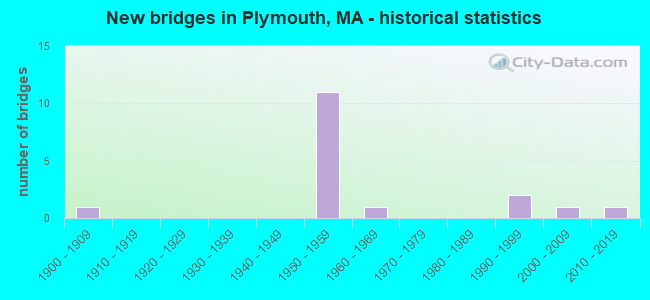
- New bridges - historical statistics
- 11900-1909
- 111950-1959
- 11960-1969
- 21990-1999
- 12000-2009
- 12010-2019

- Reconstructed bridges - Historical Statistics
- 11910-1919
- 01920-1929
- 01930-1939
- 01940-1949
- 01950-1959
- 01960-1969
- 41970-1979


- Bridge Condition - Deck
- 6.7%Very good
- 60.0%Good
- 13.3%Satisfactory
- 20.0%Fair

- Bridge Condition - Superstructure
- 11.8%Very good
- 35.3%Good
- 23.5%Satisfactory
- 29.4%Fair

- Bridge Condition - Substructure
- 5.9%Very good
- 58.8%Good
- 29.4%Satisfactory
- 5.9%Fair

- Bridge Condition - Channel
- 33.3%Very good
- 16.7%Good
- 50.0%Satisfactory
Find on map >> Show street view
Structure Number: P1300146WDOTNBI, Location: .5 M S OF RTE 44 (Lat: 41.954986, Lng: -70.662983), Route carried "on" structure: Alternate State highway 3A, Year Built: 1908, Year Reconstructed: 1919, Status: Open, Structure Length: 1.35m (4.43ft), Average Daily Traffic: 6,000 (year 2022), Truck Traffic: 5%, Average Future Daily Traffic: 36,324 (year 2033), Features Intersected: WATER TOWN BROOK, Facility Carried by Structure: ST 3 A/MAIN ST
Minimum Vertical Clearance: 30+ m (98+ ft), Kilometerpoint: 23.351, Lanes on structure: 2, Owner: State Highway Agency, Approaching Roadway Width: 12.7m (41.7ft), Material/Design: Concrete, Design/Construction: Arch - Deck, Number Of Spans In Main Unit: 1, Length of Maximum Span: 13.0m (42.7ft), Curb or Sidewalk Widths: Left: 2.1m (6.9ft), Right: 3.2m (10.5ft), Curb-To-Curb Width: 12.7m (41.7ft), Out-to-Out Width: 18.6m (61.0ft)
Condition: Superstructure: Fair, Substructure: Satisfactory, Channel: Satisfactory, Operating Rating: 47.0 metric tons, Method Used To Determine Operating Rating: Load Factor (LF), Inventory Rating: 47.0 metric tons, Method Used To Determine Inventory Rating: Load Factor (LF), Structural Evaluation: Somewhat better than minimum adequacy, Deck Geometry: Somewhat better than minimum adequacy, Waterway Adequacy: Equal to present desirable criteria, Approach Roadway Alignment: Equal to present desirable criteria, Length Of Structure Improvement: 1.40m (4.59ft), Designated Inspection Frequency: Every 24 months, Inspection Date: January 2022, Bridge Improvement Cost: $1,023,000, Roadway Improvement Cost: $103,000, Total Project Cost: $1,535,000 ( Estimate for 2022)
Find on map >> Show street view
Structure Number: P1300246XDOTNBI, Location: 3 M S OF RTE 44 (Lat: 41.942200, Lng: -70.622972), Route carried "on" structure: Alternate State highway 3A, Year Built: 1958, Status: Open, Structure Length: 0.94m (3.08ft), Average Daily Traffic: 4,600 (year 2018), Truck Traffic: 6%, Average Future Daily Traffic: 31,586 (year 2031), Design Load: H 20, Features Intersected: WATER EEL RIVER, Facility Carried by Structure: ST 3 A/WARREN AVE
Minimum Vertical Clearance: 30+ m (98+ ft), Kilometerpoint: 19.707, Lanes on structure: 2, Owner: State Highway Agency, Approaching Roadway Width: 10.4m (34.1ft), Material/Design: Prestressed concrete, Design/Construction: Slab, Number Of Spans In Main Unit: 1, Length of Maximum Span: 8.8m (28.9ft), Curb or Sidewalk Widths: Left: 1.5m (4.9ft), Right: 1.5m (4.9ft), Curb-To-Curb Width: 10.4m (34.1ft), Out-to-Out Width: 13.4m (44.0ft)
Condition: Deck: Good, Superstructure: Good, Substructure: Satisfactory, Channel: Satisfactory, Operating Rating: 53.1 metric tons, Method Used To Determine Operating Rating: Allowable Stress (AS), Inventory Rating: 50.0 metric tons, Method Used To Determine Inventory Rating: Allowable Stress (AS), Structural Evaluation: Equal to present minimum criteria, Deck Geometry: Somewhat better than minimum adequacy, Waterway Adequacy: Somewhat better than minimum adequacy, Approach Roadway Alignment: Equal to present desirable criteria, Length Of Structure Improvement: 1.00m (3.28ft), Designated Inspection Frequency: Every 24 months, Inspection Date: September 2020, Bridge Improvement Cost: $283,000, Roadway Improvement Cost: $29,000, Total Project Cost: $425,000 ( Estimate for 2022), Deck Structure Type: Concrete Precast Panels, Wearing Surface/Protective System: Wearing Surface: Bituminous, Membrane: Built-up
Find on map >> Show street view
Structure Number: P1300842AMUNNBI, Location: JUST WEST OF 3A (Lat: 41.954581, Lng: -70.663669), Route carried "on" structure: City street , Year Built: 1964, Status: Open, Structure Length: 1.01m (3.31ft), Average Daily Traffic: 17,330 (year 2020), Truck Traffic: 7%, Average Future Daily Traffic: 22,110 (year 2033), Design Load: H 20, Features Intersected: WATER TOWN BROOK, Facility Carried by Structure: HWY MARKET ST
Minimum Vertical Clearance: 30+ m (98+ ft), Kilometerpoint: 0.032, Lanes on structure: 2, Owner: Town or Township Highway Agency, Approaching Roadway Width: 11.0m (36.1ft), Material/Design: Prestressed concrete, Design/Construction: Slab, Number Of Spans In Main Unit: 1, Length of Maximum Span: 9.1m (29.9ft), Curb or Sidewalk Widths: Left: 1.5m (4.9ft), Right: 1.5m (4.9ft), Curb-To-Curb Width: 11.0m (36.1ft), Out-to-Out Width: 14.6m (47.9ft)
Condition: Deck: Satisfactory, Superstructure: Satisfactory, Substructure: Good, Channel: Very good, Operating Rating: 50.7 metric tons, Method Used To Determine Operating Rating: Load Factor (LF), Inventory Rating: 42.1 metric tons, Method Used To Determine Inventory Rating: Load Factor (LF), Structural Evaluation: Equal to present minimum criteria, Deck Geometry: Meets minimum limits, Waterway Adequacy: Superior to present desirable criteria, Approach Roadway Alignment: Somewhat better than minimum adequacy, Length Of Structure Improvement: 1.10m (3.61ft), Designated Inspection Frequency: Every 24 months, Inspection Date: January 2022, Bridge Improvement Cost: $249,000, Roadway Improvement Cost: $25,000, Total Project Cost: $374,000 ( Estimate for 2022), Deck Structure Type: Concrete Precast Panels, Wearing Surface/Protective System: Wearing Surface: Bituminous
Find on map >> Show street view
Structure Number: P13012AU0MUNNBI, Location: .2 MI W OF RTE 3A (Lat: 41.936861, Lng: -70.619139), Route carried "on" structure: City street , Year Built: 2004, Status: Open, Structure Length: 0.97m (3.18ft), Average Daily Traffic: 1,900 (year 2020), Truck Traffic: 6%, Average Future Daily Traffic: 3,159 (year 2031), Design Load: HS 20, Features Intersected: WATER EEL RIVER, Facility Carried by Structure: HWY RIVER ST
Minimum Vertical Clearance: 30+ m (98+ ft), Kilometerpoint: 1.062, Lanes on structure: 2, Owner: Town or Township Highway Agency, Approaching Roadway Width: 7.3m (24.0ft), Material/Design: Concrete, Design/Construction: Arch - Deck, Number Of Spans In Main Unit: 1, Length of Maximum Span: 9.7m (31.8ft), Curb or Sidewalk Widths: Left: 0.0m, Right: 1.8m (5.9ft), Curb-To-Curb Width: 7.3m (24.0ft), Out-to-Out Width: 9.8m (32.2ft)
Condition: Superstructure: Very good, Substructure: Good, Channel: Good, Operating Rating: 57.6 metric tons, Method Used To Determine Operating Rating: Load Factor (LF), Inventory Rating: 34.5 metric tons, Method Used To Determine Inventory Rating: Load Factor (LF), Structural Evaluation: Better than present minimum criteria, Deck Geometry: Meets minimum limits, Waterway Adequacy: Superior to present desirable criteria, Approach Roadway Alignment: Superior to present desirable criteria, Length Of Structure Improvement: 1.00m (3.28ft), Designated Inspection Frequency: Every 24 months, Underwater Inspection Frequency: Every 36 months, Inspection Date: August 2020, Underwater Inspection Date: April 2020, Bridge Improvement Cost: $576,000, Roadway Improvement Cost: $58,000, Total Project Cost: $865,000 ( Estimate for 2022)
Find on map >> Show street view
Structure Number: P13014C0NMUNNBI, Location: 184FT S. OF SUMMER ST (Lat: 41.952683, Lng: -70.667756), Route carried "on" structure: City street , Year Built: 2019, Status: Open, Structure Length: 0.82m (2.69ft), Average Daily Traffic: 3,700 (year 2018), Truck Traffic: 2%, Design Load: HL 93, Features Intersected: WATER TOWN BROOK, Facility Carried by Structure: HWY NEWFIELD ST
Minimum Vertical Clearance: 30+ m (98+ ft), Kilometerpoint: 0.000, Lanes on structure: 2, Owner: Town or Township Highway Agency, Approaching Roadway Width: 7.3m (24.0ft), Skew: 8 degrees, Material/Design: Concrete, Design/Construction: Frame, Number Of Spans In Main Unit: 1, Length of Maximum Span: 7.3m (24.0ft), Curb or Sidewalk Widths: Left: 1.9m (6.2ft), Right: 1.6m (5.2ft), Curb-To-Curb Width: 7.3m (24.0ft), Out-to-Out Width: 12.3m (40.4ft)
Condition: Deck: Very good, Superstructure: Very good, Substructure: Very good, Channel: Very good, Operating Rating: 51.8 metric tons, Method Used To Determine Operating Rating: Load and Resistance Factor Rating (LRFR) rating reported by rating factor(RF) method using HL-93 loadings, Inventory Rating: 42.1 metric tons, Method Used To Determine Inventory Rating: Load and Resistance Factor Rating (LRFR) rating reported by rating factor(RF) method using HL-93 loadings, Structural Evaluation: Equal to present desirable criteria, Deck Geometry: High priority of replacement, Waterway Adequacy: High priority of replacement, Approach Roadway Alignment: High priority of replacement, Designated Inspection Frequency: Every 24 months, Inspection Date: August 2020, Deck Structure Type: Concrete Precast Panels, Wearing Surface/Protective System: Wearing Surface: Bituminous, Membrane: Other, Deck Protection: Epoxy Coated Reinforcing
Find on map >> Show street view
Structure Number: P1302249BDOTNBI, Location: 1.5 M S OF KINGSTON TL (Lat: 41.954500, Lng: -70.682267), Route carried "on" structure: State highway 3, Year Built: 1992, Status: Open, Structure Length: 3.87m (12.70ft), Average Daily Traffic: 40,300 (year 2018), Truck Traffic: 6%, Average Future Daily Traffic: 111,025 (year 2033), Design Load: HS 20, Features Intersected: US 44 SAMOSET ST
Minimum Vertical Clearance: 30+ m (98+ ft), Kilometerpoint: 23.657, Lanes on structure: 4, Lanes under structure: 5, Base Highway Network: Yes, Owner: State Highway Agency, Approaching Roadway Width: 12.8m (42.0ft), Material/Design: Prestressed concrete continuous, Design/Construction: Stringer/Multi-beam, Number Of Spans In Main Unit: 2, Length of Maximum Span: 21.0m (68.9ft), Curb-To-Curb Width: 17.5m (57.4ft), Out-to-Out Width: 18.5m (60.7ft)
Condition: Deck: Good, Superstructure: Fair, Substructure: Good, Operating Rating: 59.9 metric tons, Method Used To Determine Operating Rating: Load Factor (LF), Inventory Rating: 35.9 metric tons, Method Used To Determine Inventory Rating: Load Factor (LF), Structural Evaluation: Somewhat better than minimum adequacy, Deck Geometry: Meets minimum limits, Underclear: Meets minimum limits, Approach Roadway Alignment: Equal to present desirable criteria, Length Of Structure Improvement: 3.90m (12.80ft), Designated Inspection Frequency: Every 24 months, Inspection Date: January 2022, Bridge Improvement Cost: $2,835,000, Roadway Improvement Cost: $284,000, Total Project Cost: $4,253,000 ( Estimate for 2022), Deck Structure Type: Concrete Cast-file-Place, Wearing Surface/Protective System: Wearing Surface: Bituminous, Membrane: Built-up, Deck Protection: Epoxy Coated Reinforcing
Find on map >> Show street view
Structure Number: P1302249CDOTNBI, Location: 1.5 M S OF KINGSTON TL (Lat: 41.954406, Lng: -70.682467), Route carried "on" structure: State highway 3, Year Built: 1992, Status: Open, Structure Length: 3.83m (12.57ft), Average Daily Traffic: 40,000 (year 2018), Truck Traffic: 6%, Average Future Daily Traffic: 111,025 (year 2033), Design Load: HS 20, Features Intersected: US 44 SAMOSET ST
Minimum Vertical Clearance: 30+ m (98+ ft), Kilometerpoint: 23.657, Lanes on structure: 3, Lanes under structure: 5, Base Highway Network: Yes, Owner: State Highway Agency, Approaching Roadway Width: 17.0m (55.8ft), Material/Design: Prestressed concrete continuous, Design/Construction: Stringer/Multi-beam, Number Of Spans In Main Unit: 2, Length of Maximum Span: 21.0m (68.9ft), Curb-To-Curb Width: 17.1m (56.1ft), Out-to-Out Width: 18.0m (59.1ft)
Condition: Deck: Good, Superstructure: Satisfactory, Substructure: Good, Operating Rating: 59.5 metric tons, Method Used To Determine Operating Rating: Load Factor (LF), Inventory Rating: 35.6 metric tons, Method Used To Determine Inventory Rating: Load Factor (LF), Structural Evaluation: Equal to present minimum criteria, Deck Geometry: Equal to present minimum criteria, Underclear: Meets minimum limits, Approach Roadway Alignment: Equal to present desirable criteria, Length Of Structure Improvement: 3.90m (12.80ft), Designated Inspection Frequency: Every 24 months, Inspection Date: January 2022, Bridge Improvement Cost: $490,000, Roadway Improvement Cost: $50,000, Total Project Cost: $736,000 ( Estimate for 2022), Deck Structure Type: Concrete Cast-file-Place, Wearing Surface/Protective System: Wearing Surface: Bituminous, Membrane: Built-up, Deck Protection: Epoxy Coated Reinforcing
Find on map >> Show street view
Structure Number: P130234B2DOTNBI, Location: 1 MI W OF RTE 3A (Lat: 41.949847, Lng: -70.678975), Route carried "on" structure: City street , Year Built: 1951, Status: Open, Structure Length: 3.32m (10.89ft), Average Daily Traffic: 21,500 (year 2018), Truck Traffic: 5%, Average Future Daily Traffic: 30,323 (year 2031), Design Load: H 20, Features Intersected: ST 3 PILGRIM HWY, Facility Carried by Structure: HWY SUMMER ST
Minimum Vertical Clearance: 30+ m (98+ ft), Kilometerpoint: 22.992, Lanes on structure: 2, Lanes under structure: 4, Owner: State Highway Agency, Approaching Roadway Width: 9.1m (29.9ft), Skew: 1 degrees, Material/Design: Concrete continuous, Design/Construction: Frame, Number Of Spans In Main Unit: 2, Length of Maximum Span: 14.9m (48.9ft), Curb or Sidewalk Widths: Left: 1.5m (4.9ft), Right: 0.3m (1.0ft), Curb-To-Curb Width: 9.1m (29.9ft), Out-to-Out Width: 11.6m (38.1ft)
Condition: Deck: Good, Superstructure: Good, Substructure: Good, Operating Rating: 43.3 metric tons, Method Used To Determine Operating Rating: Load Factor (LF), Inventory Rating: 26.0 metric tons, Method Used To Determine Inventory Rating: Load Factor (LF), Structural Evaluation: Equal to present minimum criteria, Deck Geometry: High priority of corrective action, Underclear: High priority of corrective action, Approach Roadway Alignment: Equal to present desirable criteria, Length Of Structure Improvement: 3.40m (11.15ft), Designated Inspection Frequency: Every 24 months, Inspection Date: July 2020, Bridge Improvement Cost: $1,550,000, Roadway Improvement Cost: $156,000, Total Project Cost: $2,326,000 ( Estimate for 2022), Deck Structure Type: Concrete Cast-file-Place, Wearing Surface/Protective System: Wearing Surface: Bituminous, Membrane: Built-up
Find on map >> Show street view
Structure Number: P130254CKDOTNBI, Location: 1.5 M E OF RTE 3 (Lat: 41.937400, Lng: -70.619164), Route carried "on" structure: Other road , Year Built: 1951, Status: Open, Structure Length: 2.65m (8.69ft), Average Daily Traffic: 12,112 (year 2019), Truck Traffic: 5%, Average Future Daily Traffic: 24,163 (year 2032), Design Load: H 20, Features Intersected: WATER EEL RIVER, Facility Carried by Structure: HWY PLIMTH PLNTN
Minimum Vertical Clearance: 30+ m (98+ ft), Kilometerpoint: 17.574, Lanes on structure: 2, Owner: State Highway Agency, Approaching Roadway Width: 12.2m (40.0ft), Material/Design: Concrete continuous, Design/Construction: Slab, Number Of Spans In Main Unit: 3, Length of Maximum Span: 8.5m (27.9ft), Curb or Sidewalk Widths: Left: 0.8m (2.6ft), Right: 0.8m (2.6ft), Curb-To-Curb Width: 12.2m (40.0ft), Out-to-Out Width: 14.3m (46.9ft)
Condition: Deck: Fair, Superstructure: Fair, Substructure: Satisfactory, Channel: Satisfactory, Operating Rating: 65.3 metric tons, Method Used To Determine Operating Rating: Allowable Stress (AS), Inventory Rating: 38.8 metric tons, Method Used To Determine Inventory Rating: Allowable Stress (AS), Structural Evaluation: Somewhat better than minimum adequacy, Deck Geometry: Somewhat better than minimum adequacy, Waterway Adequacy: Equal to present desirable criteria, Approach Roadway Alignment: Equal to present desirable criteria, Length Of Structure Improvement: 2.70m (8.86ft), Designated Inspection Frequency: Every 24 months, Underwater Inspection Frequency: Every 36 months, Inspection Date: June 2021, Underwater Inspection Date: April 2020, Bridge Improvement Cost: $1,517,000, Roadway Improvement Cost: $152,000, Total Project Cost: $2,276,000 ( Estimate for 2022), Deck Structure Type: Concrete Cast-file-Place, Wearing Surface/Protective System: Wearing Surface: Bituminous, Membrane: Built-up
Find on map >> Show street view
Structure Number: P13026499DOTNBI, Location: 2.5 M S OF KINGSTON TL (Lat: 41.944336, Lng: -70.675197), Route carried "on" structure: State highway 3, Year Built: 1950, Year Reconstructed: 1978, Status: Open, Structure Length: 1.92m (6.30ft), Average Daily Traffic: 39,928 (year 2018), Truck Traffic: 6%, Average Future Daily Traffic: 67,436 (year 2032), Design Load: H 20, Features Intersected: HWY BILLINGTON ST
Minimum Vertical Clearance: 30+ m (98+ ft), Kilometerpoint: 21.774, Lanes on structure: 2, Lanes under structure: 2, Base Highway Network: Yes, Owner: State Highway Agency, Approaching Roadway Width: 11.0m (36.1ft), Skew: 24 degrees, Material/Design: Concrete, Design/Construction: Frame, Number Of Spans In Main Unit: 1, Length of Maximum Span: 16.2m (53.1ft), Curb-To-Curb Width: 11.2m (36.7ft), Out-to-Out Width: 30.2m (99.1ft)
Condition: Deck: Good, Superstructure: Good, Substructure: Good, Operating Rating: 52.8 metric tons, Method Used To Determine Operating Rating: Load Factor (LF), Inventory Rating: 31.7 metric tons, Method Used To Determine Inventory Rating: Load Factor (LF), Structural Evaluation: Better than present minimum criteria, Deck Geometry: Somewhat better than minimum adequacy, Underclear: Meets minimum limits, Approach Roadway Alignment: Equal to present desirable criteria, Length Of Structure Improvement: 2.00m (6.56ft), Designated Inspection Frequency: Every 24 months, Inspection Date: October 2020, Bridge Improvement Cost: $2,373,000, Roadway Improvement Cost: $238,000, Total Project Cost: $3,560,000 ( Estimate for 2022), Deck Structure Type: Concrete Cast-file-Place, Wearing Surface/Protective System: Wearing Surface: Bituminous, Membrane: Built-up
Find on map >> Show street view
Structure Number: P1302649ADOTNBI, Location: 2.5 M S OF KINGSTON TL (Lat: 41.944511, Lng: -70.675144), Route carried "on" structure: State highway 3, Year Built: 1950, Year Reconstructed: 1978, Status: Open, Structure Length: 1.92m (6.30ft), Average Daily Traffic: 40,284 (year 2018), Truck Traffic: 6%, Average Future Daily Traffic: 67,436 (year 2032), Design Load: H 20, Features Intersected: HWY BILLINGTON ST
Minimum Vertical Clearance: 30+ m (98+ ft), Kilometerpoint: 21.790, Lanes on structure: 2, Lanes under structure: 2, Base Highway Network: Yes, Owner: State Highway Agency, Approaching Roadway Width: 11.0m (36.1ft), Skew: 24 degrees, Material/Design: Concrete, Design/Construction: Frame, Number Of Spans In Main Unit: 1, Length of Maximum Span: 16.2m (53.1ft), Curb-To-Curb Width: 11.8m (38.7ft), Out-to-Out Width: 30.2m (99.1ft)
Condition: Deck: Good, Superstructure: Good, Substructure: Good, Operating Rating: 52.8 metric tons, Method Used To Determine Operating Rating: Load Factor (LF), Inventory Rating: 31.7 metric tons, Method Used To Determine Inventory Rating: Load Factor (LF), Structural Evaluation: Better than present minimum criteria, Deck Geometry: Equal to present minimum criteria, Underclear: Meets minimum limits, Approach Roadway Alignment: Equal to present desirable criteria, Length Of Structure Improvement: 2.00m (6.56ft), Designated Inspection Frequency: Every 24 months, Inspection Date: October 2020, Bridge Improvement Cost: $2,373,000, Roadway Improvement Cost: $238,000, Total Project Cost: $3,560,000 ( Estimate for 2022), Deck Structure Type: Concrete Cast-file-Place, Wearing Surface/Protective System: Wearing Surface: Bituminous, Membrane: Built-up
Find on map >> Show street view
Structure Number: P13028498DOTNBI, Location: 3.5 M S OF KINGSTON TL (Lat: 41.935742, Lng: -70.656644), Route carried "on" structure: State highway 3, Year Built: 1950, Year Reconstructed: 1978, Status: Open, Structure Length: 1.74m (5.71ft), Average Daily Traffic: 81,327 (year 2018), Truck Traffic: 4%, Average Future Daily Traffic: 157,930 (year 2032), Design Load: H 20, Features Intersected: HWY LONG POND RD
Minimum Vertical Clearance: 30+ m (98+ ft), Kilometerpoint: 20.004, Lanes on structure: 6, Lanes under structure: 4, Base Highway Network: Yes, Owner: State Highway Agency, Approaching Roadway Width: 29.3m (96.1ft), Skew: 30 degrees, Material/Design: Concrete, Design/Construction: Frame, Number Of Spans In Main Unit: 1, Length of Maximum Span: 15.2m (49.9ft), Curb-To-Curb Width: 29.3m (96.1ft), Out-to-Out Width: 30.8m (101.0ft)
Condition: Deck: Satisfactory, Superstructure: Satisfactory, Substructure: Good, Operating Rating: 76.4 metric tons, Method Used To Determine Operating Rating: Load Factor (LF), Inventory Rating: 43.6 metric tons, Method Used To Determine Inventory Rating: Load Factor (LF), Structural Evaluation: Equal to present minimum criteria, Deck Geometry: Better than present minimum criteria, Underclear: Meets minimum limits, Approach Roadway Alignment: Equal to present desirable criteria, Length Of Structure Improvement: 1.80m (5.91ft), Designated Inspection Frequency: Every 24 months, Inspection Date: August 2021, Bridge Improvement Cost: $34,000, Roadway Improvement Cost: $4,000, Total Project Cost: $52,000 ( Estimate for 2022), Deck Structure Type: Concrete Cast-file-Place, Wearing Surface/Protective System: Wearing Surface: Bituminous, Membrane: Built-up
Find on map >> Show street view
Structure Number: P1302946YDOTNBI, Location: 3.5 M S OF RTE 44 (Lat: 41.938628, Lng: -70.613383), Route carried "on" structure: Alternate State highway 30, Year Built: 1950, Status: Open, Structure Length: 5.24m (17.19ft), Average Daily Traffic: 10,184 (year 2018), Truck Traffic: 6%, Average Future Daily Traffic: 27,954 (year 2031), Design Load: H 20, Features Intersected: HWY PLIMOTH PLNTN HWY, Facility Carried by Structure: ST 3 A/SB WARREN
Minimum Vertical Clearance: 30+ m (98+ ft), Kilometerpoint: 18.781, Lanes on structure: 1, Lanes under structure: 2, Owner: State Highway Agency, Approaching Roadway Width: 8.8m (28.9ft), Skew: 5 degrees, Material/Design: Steel, Design/Construction: Stringer/Multi-beam, Number Of Spans In Main Unit: 3, Length of Maximum Span: 24.1m (79.1ft), Curb or Sidewalk Widths: Left: 0.7m (2.3ft), Right: 0.7m (2.3ft), Curb-To-Curb Width: 9.1m (29.9ft), Out-to-Out Width: 11.3m (37.1ft)
Condition: Deck: Fair, Superstructure: Satisfactory, Substructure: Satisfactory, Operating Rating: 37.8 metric tons, Method Used To Determine Operating Rating: Allowable Stress (AS), Inventory Rating: 24.9 metric tons, Method Used To Determine Inventory Rating: Allowable Stress (AS), Structural Evaluation: Equal to present minimum criteria, Deck Geometry: High priority of corrective action, Underclear: Meets minimum limits, Approach Roadway Alignment: Equal to present desirable criteria, Length Of Structure Improvement: 5.30m (17.39ft), Designated Inspection Frequency: Every 24 months, Inspection Date: September 2020, Bridge Improvement Cost: $2,353,000, Roadway Improvement Cost: $236,000, Total Project Cost: $3,530,000 ( Estimate for 2022), Deck Structure Type: Concrete Cast-file-Place, Wearing Surface/Protective System: Wearing Surface: Bituminous, Membrane: Built-up
Find on map >> Show street view
Structure Number: P130304B3DOTNBI, Location: 1.5 M S OF RTE 3A (Lat: 41.933914, Lng: -70.629792), Route carried "on" structure: City street , Year Built: 1950, Status: Open, Structure Length: 3.66m (12.01ft), Average Daily Traffic: 4,200 (year 2022), Truck Traffic: 3%, Average Future Daily Traffic: 3,948 (year 2033), Design Load: H 20, Features Intersected: HWY PLIMOTH PLNTN HWY, Facility Carried by Structure: HWY SANDWICH RD
Minimum Vertical Clearance: 30+ m (98+ ft), Kilometerpoint: 0.000, Lanes on structure: 2, Lanes under structure: 2, Owner: State Highway Agency, Approaching Roadway Width: 9.1m (29.9ft), Skew: 2 degrees, Material/Design: Concrete continuous, Design/Construction: Frame, Number Of Spans In Main Unit: 2, Length of Maximum Span: 17.1m (56.1ft), Curb or Sidewalk Widths: Left: 0.8m (2.6ft), Right: 0.8m (2.6ft), Curb-To-Curb Width: 9.1m (29.9ft), Out-to-Out Width: 11.3m (37.1ft)
Condition: Deck: Good, Superstructure: Good, Substructure: Good, Operating Rating: 52.8 metric tons, Method Used To Determine Operating Rating: Load Factor (LF), Inventory Rating: 31.6 metric tons, Method Used To Determine Inventory Rating: Load Factor (LF), Structural Evaluation: Better than present minimum criteria, Deck Geometry: Meets minimum limits, Underclear: Meets minimum limits, Approach Roadway Alignment: Equal to present desirable criteria, Length Of Structure Improvement: 3.70m (12.14ft), Designated Inspection Frequency: Every 24 months, Inspection Date: January 2022, Bridge Improvement Cost: $1,643,000, Roadway Improvement Cost: $165,000, Total Project Cost: $2,465,000 ( Estimate for 2022), Deck Structure Type: Concrete Cast-file-Place, Wearing Surface/Protective System: Wearing Surface: Bituminous, Membrane: Built-up
Find on map >> Show street view
Structure Number: P130314B4DOTNBI, Location: 1.13 KM W OF RTE 3A (Lat: 41.935633, Lng: -70.625269), Route carried "on" structure: Other road , Year Built: 1951, Status: Open, Structure Length: 5.55m (18.21ft), Average Daily Traffic: 2,849 (year 2018), Truck Traffic: 8%, Average Future Daily Traffic: 4,738 (year 2031), Design Load: H 20, Features Intersected: HWY PLIMOTH PLNTN HWY, Facility Carried by Structure: HWY RIVER ST
Minimum Vertical Clearance: 30+ m (98+ ft), Kilometerpoint: 0.563, Lanes on structure: 2, Lanes under structure: 2, Owner: State Highway Agency, Approaching Roadway Width: 8.5m (27.9ft), Skew: 4 degrees, Material/Design: Steel, Design/Construction: Stringer/Multi-beam, Number Of Spans In Main Unit: 3, Length of Maximum Span: 21.3m (69.9ft), Curb or Sidewalk Widths: Left: 0.8m (2.6ft), Right: 1.7m (5.6ft), Curb-To-Curb Width: 9.1m (29.9ft), Out-to-Out Width: 12.2m (40.0ft)
Condition: Deck: Fair, Superstructure: Fair, Substructure: Fair, Operating Rating: 45.3 metric tons, Method Used To Determine Operating Rating: Allowable Stress (AS), Inventory Rating: 24.6 metric tons, Method Used To Determine Inventory Rating: Allowable Stress (AS), Structural Evaluation: Somewhat better than minimum adequacy, Deck Geometry: Meets minimum limits, Underclear: Meets minimum limits, Approach Roadway Alignment: Equal to present minimum criteria, Length Of Structure Improvement: 5.60m (18.37ft), Designated Inspection Frequency: Every 24 months, Inspection Date: November 2020, Bridge Improvement Cost: $2,684,000, Roadway Improvement Cost: $269,000, Total Project Cost: $4,027,000 ( Estimate for 2022), Deck Structure Type: Concrete Cast-file-Place, Wearing Surface/Protective System: Wearing Surface: Bituminous, Membrane: Built-up
Find on map >> Show street view
Structure Number: P130324CJDOTNBI, Location: 1.4 M S OF RTE 3 (Lat: 41.937608, Lng: -70.618072), Route carried "on" structure: City street , Year Built: 1951, Status: Open, Structure Length: 1.35m (4.43ft), Average Daily Traffic: 18,700 (year 2020), Truck Traffic: 7%, Average Future Daily Traffic: 30,875 (year 2031), Design Load: H 20, Features Intersected: HWY CLIFFORD RD, Facility Carried by Structure: HWY PLIMTH PLNTN
Minimum Vertical Clearance: 30+ m (98+ ft), Kilometerpoint: 2.253, Lanes on structure: 2, Lanes under structure: 2, Owner: State Highway Agency, Approaching Roadway Width: 12.2m (40.0ft), Material/Design: Concrete, Design/Construction: Frame, Number Of Spans In Main Unit: 1, Length of Maximum Span: 12.4m (40.7ft), Curb or Sidewalk Widths: Left: 0.8m (2.6ft), Right: 0.8m (2.6ft), Curb-To-Curb Width: 12.2m (40.0ft), Out-to-Out Width: 14.3m (46.9ft)
Condition: Deck: Good, Superstructure: Good, Substructure: Good, Operating Rating: 55.1 metric tons, Method Used To Determine Operating Rating: Load Factor (LF), Inventory Rating: 33.0 metric tons, Method Used To Determine Inventory Rating: Load Factor (LF), Structural Evaluation: Better than present minimum criteria, Deck Geometry: Somewhat better than minimum adequacy, Underclear: Meets minimum limits, Approach Roadway Alignment: Equal to present desirable criteria, Length Of Structure Improvement: 1.40m (4.59ft), Designated Inspection Frequency: Every 24 months, Inspection Date: May 2020, Bridge Improvement Cost: $159,000, Roadway Improvement Cost: $16,000, Total Project Cost: $239,000 ( Estimate for 2022), Deck Structure Type: Concrete Cast-file-Place, Wearing Surface/Protective System: Wearing Surface: Bituminous, Membrane: Built-up
Find on map >> Show street view
Structure Number: P13033497DOTNBI, Location: .8 MI SO OF LONG POND RD (Lat: 41.932217, Lng: -70.641956), Route carried "on" structure: State highway 3, Year Built: 1956, Year Reconstructed: 1978, Status: Open, Structure Length: 3.57m (11.71ft), Average Daily Traffic: 29,500 (year 2019), Truck Traffic: 8%, Average Future Daily Traffic: 61,909 (year 2033), Design Load: H 20, Features Intersected: HWY PLIMOTH PLNTN HWY
Minimum Vertical Clearance: 30+ m (98+ ft), Kilometerpoint: 18.732, Lanes on structure: 2, Lanes under structure: 2, Base Highway Network: Yes, Owner: State Highway Agency, Approaching Roadway Width: 11.9m (39.0ft), Skew: 6 degrees, Material/Design: Steel, Design/Construction: Stringer/Multi-beam, Number Of Spans In Main Unit: 1, Length of Maximum Span: 32.6m (107.0ft), Curb-To-Curb Width: 11.8m (38.7ft), Out-to-Out Width: 12.8m (42.0ft)
Condition: Deck: Good, Superstructure: Fair, Substructure: Satisfactory, Operating Rating: 37.7 metric tons, Method Used To Determine Operating Rating: Load Factor (LF), Inventory Rating: 22.6 metric tons, Method Used To Determine Inventory Rating: Load Factor (LF), Structural Evaluation: Somewhat better than minimum adequacy, Deck Geometry: Equal to present minimum criteria, Underclear: High priority of corrective action, Approach Roadway Alignment: Equal to present desirable criteria, Length Of Structure Improvement: 3.60m (11.81ft), Designated Inspection Frequency: Every 24 months, Inspection Date: January 2022, Bridge Improvement Cost: $1,811,000, Roadway Improvement Cost: $182,000, Total Project Cost: $2,717,000 ( Estimate for 2022), Deck Structure Type: Concrete Cast-file-Place, Wearing Surface/Protective System: Wearing Surface: Latex Concrete, Deck Protection: Cathodic Protection