Bridge Statistics for Swansea, Massachusetts (MA)
Condition, Traffic, Stress, Structural Evaluation, Project Costs
- National Bridge Inventory (NBI) Statistics
- 19Number of bridges
- 226ft / 69.2mTotal length
- $48,928,000Total costs
- 542,688Total average daily traffic
- 6,679Total average daily truck traffic
- National Bridge Inventory (NBI) Registered Bridges for Swansea
- No street view available for this location
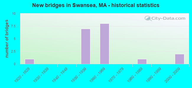
- New bridges - historical statistics
- 11920-1929
- 71950-1959
- 81960-1969
- 11980-1989
- 22000-2009

- Reconstructed bridges - Historical Statistics
- 11960-1969
- 01970-1979
- 01980-1989
- 01990-1999
- 12000-2009
- 22010-2019


- Bridge Condition - Deck
- 20.0%Very good
- 20.0%Good
- 30.0%Satisfactory
- 20.0%Fair
- 10.0%Poor

- Bridge Condition - Superstructure
- 20.0%Very good
- 10.0%Good
- 40.0%Satisfactory
- 30.0%Fair

- Bridge Condition - Substructure
- 20.0%Very good
- 30.0%Good
- 30.0%Satisfactory
- 10.0%Fair
- 10.0%Poor

- Bridge Condition - Channel
- 16.7%Very good
- 50.0%Good
- 16.7%Fair
- 16.7%Poor
Find on map >> Show street view
Structure Number: S350013LXMUNNBI, Location: .6 MI. W. OF RT. 6 (Lat: 41.772278, Lng: -71.282967), Route carried "on" structure: City street , Year Built: 2007, Status: Open, Structure Length: 4.63m (15.19ft), Average Daily Traffic: 1,300 (year 2019), Truck Traffic: 8%, Average Future Daily Traffic: 3,474 (year 2032), Design Load: HS 20, Features Intersected: WATER PALMER RIVER, Facility Carried by Structure: HWY OLD PROV RD
Minimum Vertical Clearance: 30+ m (98+ ft), Kilometerpoint: 0.563, Lanes on structure: 2, Owner: Town or Township Highway Agency, Approaching Roadway Width: 10.0m (32.8ft), Material/Design: Prestressed concrete, Design/Construction: Slab, Number Of Spans In Main Unit: 5, Length of Maximum Span: 9.1m (29.9ft), Curb or Sidewalk Widths: Left: 0.0m, Right: 1.8m (5.9ft), Curb-To-Curb Width: 7.3m (24.0ft), Out-to-Out Width: 10.2m (33.5ft)
Condition: Deck: Good, Superstructure: Good, Substructure: Good, Channel: Very good, Operating Rating: 56.6 metric tons, Method Used To Determine Operating Rating: Load Factor (LF), Inventory Rating: 33.9 metric tons, Method Used To Determine Inventory Rating: Load Factor (LF), Structural Evaluation: Better than present minimum criteria, Deck Geometry: Meets minimum limits, Waterway Adequacy: Better than present minimum criteria, Approach Roadway Alignment: Equal to present minimum criteria, Length Of Structure Improvement: 4.70m (15.42ft), Designated Inspection Frequency: Every 24 months, Underwater Inspection Frequency: Every 36 months, Inspection Date: June 2021, Underwater Inspection Date: July 2021, Bridge Improvement Cost: $2,698,000, Roadway Improvement Cost: $270,000, Total Project Cost: $4,048,000 ( Estimate for 2022), Deck Structure Type: Concrete Precast Panels, Wearing Surface/Protective System: Wearing Surface: Bituminous, Membrane: Preformed Fabric, Deck Protection: Internally Sealed
Find on map >> Show street view
Structure Number: S350023PEDOTNBI, Location: 1.7MI E OF R.I.S.L. (Lat: 41.733644, Lng: -71.215392), Route carried "on" structure: State highway 103, Year Built: 1957, Status: Open, Structure Length: 4.54m (14.90ft), Average Daily Traffic: 11,644 (year 2021), Truck Traffic: 6%, Average Future Daily Traffic: 29,691 (year 2032), Design Load: H 20, Features Intersected: WATER COLES RIVER
Minimum Vertical Clearance: 30+ m (98+ ft), Kilometerpoint: 0.000, Lanes on structure: 2, Owner: State Highway Agency, Approaching Roadway Width: 13.4m (44.0ft), Material/Design: Prestressed concrete, Design/Construction: Stringer/Multi-beam, Number Of Spans In Main Unit: 3, Length of Maximum Span: 14.9m (48.9ft), Curb or Sidewalk Widths: Left: 1.9m (6.2ft), Right: 1.9m (6.2ft), Curb-To-Curb Width: 13.4m (44.0ft), Out-to-Out Width: 17.2m (56.4ft)
Condition: Deck: Poor, Superstructure: Satisfactory, Substructure: Satisfactory, Channel: Fair, Operating Rating: 61.3 metric tons, Method Used To Determine Operating Rating: Allowable Stress (AS), Inventory Rating: 33.2 metric tons, Method Used To Determine Inventory Rating: Allowable Stress (AS), Structural Evaluation: Equal to present minimum criteria, Deck Geometry: Equal to present minimum criteria, Waterway Adequacy: Equal to present desirable criteria, Approach Roadway Alignment: Equal to present desirable criteria, Length Of Structure Improvement: 4.60m (15.09ft), Designated Inspection Frequency: Every 12 months, Underwater Inspection Frequency: Every 36 months, Other Special Inspection Frequency: Every 12 months, Inspection Date: August 2021, Underwater Inspection Date: Febuary 2021, Other Special Inspection Date: August 2021, Bridge Improvement Cost: $2,486,000, Roadway Improvement Cost: $249,000, Total Project Cost: $3,730,000 ( Estimate for 2022), Deck Structure Type: Concrete Cast-file-Place, Wearing Surface/Protective System: Wearing Surface: Epoxy Overlay
Find on map >> Show street view
Structure Number: S350073N5DOTNBI, Location: .9 MI SE OF I 195 (Lat: 41.746542, Lng: -71.202164), Route carried "on" structure: US 6, Year Built: 1926, Year Reconstructed: 1972, Status: Open, Structure Length: 0.76m (2.49ft), Average Daily Traffic: 19,200 (year 2020), Truck Traffic: 6%, Average Future Daily Traffic: 46,905 (year 2032), Design Load: H 20, Features Intersected: WATER COLE RIVER
Minimum Vertical Clearance: 30+ m (98+ ft), Kilometerpoint: 55.000, Lanes on structure: 4, Owner: State Highway Agency, Approaching Roadway Width: 15.8m (51.8ft), Skew: 3 degrees, Material/Design: Prestressed concrete, Design/Construction: Slab, Number Of Spans In Main Unit: 1, Length of Maximum Span: 7.0m (23.0ft), Curb or Sidewalk Widths: Left: 0.9m (3.0ft), Right: 2.0m (6.6ft), Curb-To-Curb Width: 15.8m (51.8ft), Out-to-Out Width: 18.6m (61.0ft)
Condition: Deck: Fair, Superstructure: Fair, Substructure: Poor, Channel: Poor, Operating Rating: 64.0 metric tons, Method Used To Determine Operating Rating: Load Factor (LF), Inventory Rating: 38.3 metric tons, Method Used To Determine Inventory Rating: Load Factor (LF), Structural Evaluation: Meets minimum limits, Deck Geometry: Meets minimum limits, Waterway Adequacy: Equal to present desirable criteria, Approach Roadway Alignment: Equal to present desirable criteria, Length Of Structure Improvement: 0.80m (2.62ft), Designated Inspection Frequency: Every 12 months, Underwater Inspection Frequency: Every 12 months, Inspection Date: July 2021, Underwater Inspection Date: May 2021, Bridge Improvement Cost: $585,000, Roadway Improvement Cost: $59,000, Total Project Cost: $878,000 ( Estimate for 2022), Deck Structure Type: Concrete Precast Panels, Wearing Surface/Protective System: Wearing Surface: Bituminous, Membrane: Built-up
Find on map >> Show street view
Structure Number: S350118DRDOTNBI, Location: .4 MI.NE OF US 6 (Lat: 41.774339, Lng: -71.261733), Route carried "on" structure: State highway 136, Year Built: 2007, Status: Open, Structure Length: 8.92m (29.27ft), Average Daily Traffic: 26,000 (year 2020), Truck Traffic: 6%, Average Future Daily Traffic: 37,903 (year 2033), Design Load: HS 20, Features Intersected: I 195
Minimum Vertical Clearance: 30+ m (98+ ft), Kilometerpoint: 0.612, Lanes on structure: 2, Lanes under structure: 8, Base Highway Network: Yes, Owner: State Highway Agency, Approaching Roadway Width: 12.8m (42.0ft), Material/Design: Prestressed concrete continuous, Design/Construction: Stringer/Multi-beam, Number Of Spans In Main Unit: 3, Length of Maximum Span: 33.2m (108.9ft), Curb or Sidewalk Widths: Left: 1.7m (5.6ft), Right: 0.0m, Curb-To-Curb Width: 12.8m (42.0ft), Out-to-Out Width: 15.3m (50.2ft)
Condition: Deck: Satisfactory, Superstructure: Satisfactory, Substructure: Good, Operating Rating: 82.3 metric tons, Method Used To Determine Operating Rating: Load Factor (LF), Inventory Rating: 49.3 metric tons, Method Used To Determine Inventory Rating: Load Factor (LF), Structural Evaluation: Equal to present minimum criteria, Deck Geometry: Somewhat better than minimum adequacy, Underclear: Somewhat better than minimum adequacy, Approach Roadway Alignment: Equal to present desirable criteria, Length Of Structure Improvement: 9.00m (29.53ft), Designated Inspection Frequency: Every 24 months, Inspection Date: January 2022, Bridge Improvement Cost: $510,000, Roadway Improvement Cost: $52,000, Total Project Cost: $766,000 ( Estimate for 2022), Deck Structure Type: Concrete Cast-file-Place, Wearing Surface/Protective System: Wearing Surface: Monolithic Concrete, Deck Protection: Epoxy Coated Reinforcing
Find on map >> Show street view
Structure Number: S350123WVDOTNBI, Location: .9 MI SE OF JMS.REYNLS RD (Lat: 41.770136, Lng: -71.246792), Route carried "on" structure: City street , Year Built: 1959, Status: Open, Structure Length: 8.90m (29.20ft), Average Daily Traffic: 2,300 (year 2018), Truck Traffic: 9%, Average Future Daily Traffic: 3,269 (year 2031), Design Load: H 20, Features Intersected: I 195, Facility Carried by Structure: HWY VINNICUM RD
Minimum Vertical Clearance: 30+ m (98+ ft), Kilometerpoint: 0.000, Lanes on structure: 2, Lanes under structure: 6, Owner: State Highway Agency, Approaching Roadway Width: 9.8m (32.2ft), Skew: 2 degrees, Material/Design: Steel, Design/Construction: Stringer/Multi-beam, Number Of Spans In Main Unit: 5, Length of Maximum Span: 24.4m (80.1ft), Curb or Sidewalk Widths: Left: 0.5m (1.6ft), Right: 1.5m (4.9ft), Curb-To-Curb Width: 9.8m (32.2ft), Out-to-Out Width: 12.7m (41.7ft)
Condition: Deck: Satisfactory, Superstructure: Satisfactory, Substructure: Satisfactory, Operating Rating: 46.0 metric tons, Method Used To Determine Operating Rating: Load Factor (LF), Inventory Rating: 27.6 metric tons, Method Used To Determine Inventory Rating: Load Factor (LF), Structural Evaluation: Equal to present minimum criteria, Deck Geometry: Meets minimum limits, Underclear: High priority of corrective action, Approach Roadway Alignment: Equal to present desirable criteria, Length Of Structure Improvement: 9.00m (29.53ft), Designated Inspection Frequency: Every 24 months, Inspection Date: September 2020, Bridge Improvement Cost: $4,490,000, Roadway Improvement Cost: $450,000, Total Project Cost: $6,736,000 ( Estimate for 2022), Deck Structure Type: Concrete Cast-file-Place, Wearing Surface/Protective System: Wearing Surface: Bituminous, Membrane: Built-up
Find on map >> Show street view
Structure Number: S350133YBDOTNBI, Location: .5 MI NW OF US 6 (Lat: 41.755350, Lng: -71.224275), Route carried "on" structure: City street , Year Built: 1959, Status: Open, Structure Length: 12.25m (40.19ft), Average Daily Traffic: 10,076 (year 2019), Truck Traffic: 5%, Average Future Daily Traffic: 21,163 (year 2032), Design Load: H 20, Features Intersected: I 195, Facility Carried by Structure: HWY MAPLE AVE
Minimum Vertical Clearance: 30+ m (98+ ft), Kilometerpoint: 0.064, Lanes on structure: 2, Lanes under structure: 6, Owner: State Highway Agency, Approaching Roadway Width: 12.2m (40.0ft), Skew: 4 degrees, Material/Design: Steel, Design/Construction: Stringer/Multi-beam, Number Of Spans In Main Unit: 5, Length of Maximum Span: 32.6m (107.0ft), Curb or Sidewalk Widths: Left: 0.5m (1.6ft), Right: 1.5m (4.9ft), Curb-To-Curb Width: 12.2m (40.0ft), Out-to-Out Width: 15.2m (49.9ft)
Condition: Deck: Satisfactory, Superstructure: Fair, Substructure: Satisfactory, Operating Rating: 40.9 metric tons, Method Used To Determine Operating Rating: Allowable Stress (AS), Inventory Rating: 21.6 metric tons, Method Used To Determine Inventory Rating: Allowable Stress (AS), Structural Evaluation: Somewhat better than minimum adequacy, Deck Geometry: Somewhat better than minimum adequacy, Underclear: High priority of corrective action, Approach Roadway Alignment: Equal to present desirable criteria, Length Of Structure Improvement: 12.30m (40.35ft), Designated Inspection Frequency: Every 24 months, Inspection Date: September 2021, Bridge Improvement Cost: $7,344,000, Roadway Improvement Cost: $735,000, Total Project Cost: $11,017,000 ( Estimate for 2022), Deck Structure Type: Concrete Cast-file-Place, Wearing Surface/Protective System: Wearing Surface: Bituminous, Membrane: Built-up
Find on map >> Show street view
Structure Number: S350143WPDOTNBI, Location: US 6 AT I 195 (Lat: 41.749919, Lng: -71.218372), Route carried "on" structure: US 6, Year Built: 1960, Year Reconstructed: 2007, Status: Open, Structure Length: 11.61m (38.09ft), Average Daily Traffic: 23,932 (year 2019), Truck Traffic: 2%, Average Future Daily Traffic: 55,433 (year 2031), Design Load: HS 20, Features Intersected: I 195
Minimum Vertical Clearance: 30+ m (98+ ft), Kilometerpoint: 12.018, Lanes on structure: 5, Lanes under structure: 7, Owner: State Highway Agency, Approaching Roadway Width: 18.3m (60.0ft), Skew: 4 degrees, Material/Design: Steel, Design/Construction: Stringer/Multi-beam, Number Of Spans In Main Unit: 5, Length of Maximum Span: 32.0m (105.0ft), Curb or Sidewalk Widths: Left: 1.5m (4.9ft), Right: 1.5m (4.9ft), Curb-To-Curb Width: 18.3m (60.0ft), Out-to-Out Width: 22.1m (72.5ft)
Condition: Deck: Good, Superstructure: Satisfactory, Substructure: Good, Operating Rating: 52.4 metric tons, Method Used To Determine Operating Rating: Allowable Stress (AS), Inventory Rating: 27.6 metric tons, Method Used To Determine Inventory Rating: Allowable Stress (AS), Structural Evaluation: Equal to present minimum criteria, Deck Geometry: High priority of replacement, Underclear: High priority of corrective action, Approach Roadway Alignment: Equal to present desirable criteria, Length Of Structure Improvement: 11.70m (38.39ft), Designated Inspection Frequency: Every 24 months, Inspection Date: October 2020, Bridge Improvement Cost: $10,157,000, Roadway Improvement Cost: $1,016,000, Total Project Cost: $15,236,000 ( Estimate for 2022), Deck Structure Type: Concrete Cast-file-Place, Wearing Surface/Protective System: Wearing Surface: Bituminous, Membrane: Built-up, Deck Protection: Epoxy Coated Reinforcing
Find on map >> Show street view
Structure Number: S350173WTDOTNBI, Location: .8 MI SW OF US 6 (Lat: 41.733081, Lng: -71.196994), Route carried "on" structure: City street , Year Built: 1960, Status: Open, Structure Length: 9.08m (29.79ft), Average Daily Traffic: 5,850 (year 2019), Truck Traffic: 6%, Average Future Daily Traffic: 27,366 (year 2032), Design Load: H 20, Features Intersected: I 195, Facility Carried by Structure: HWY GARDNRS NECK
Minimum Vertical Clearance: 30+ m (98+ ft), Kilometerpoint: 0.100, Lanes on structure: 2, Lanes under structure: 6, Owner: State Highway Agency, Approaching Roadway Width: 8.5m (27.9ft), Skew: 1 degrees, Material/Design: Steel, Design/Construction: Stringer/Multi-beam, Number Of Spans In Main Unit: 5, Length of Maximum Span: 22.9m (75.1ft), Curb or Sidewalk Widths: Left: 0.5m (1.6ft), Right: 1.5m (4.9ft), Curb-To-Curb Width: 8.5m (27.9ft), Out-to-Out Width: 11.6m (38.1ft)
Condition: Deck: Fair, Superstructure: Fair, Substructure: Fair, Operating Rating: 40.5 metric tons, Method Used To Determine Operating Rating: Allowable Stress (AS), Inventory Rating: 21.9 metric tons, Method Used To Determine Inventory Rating: Allowable Stress (AS), Structural Evaluation: Somewhat better than minimum adequacy, Deck Geometry: Meets minimum limits, Underclear: High priority of corrective action, Approach Roadway Alignment: Better than present minimum criteria, Length Of Structure Improvement: 9.10m (29.86ft), Designated Inspection Frequency: Every 24 months, Inspection Date: September 2021, Bridge Improvement Cost: $4,147,000, Roadway Improvement Cost: $415,000, Total Project Cost: $6,221,000 ( Estimate for 2022), Deck Structure Type: Concrete Cast-file-Place, Wearing Surface/Protective System: Wearing Surface: Bituminous, Membrane: Built-up
Find on map >> Show street view
Structure Number: S350183U8DOTNBI, Location: .9 MI NW OF SOMERSET T.L. (Lat: 41.736347, Lng: -71.202775), Route carried "on" structure: Interstate 195, Year Built: 1960, Year Reconstructed: 2015, Status: Open, Structure Length: 3.89m (12.76ft), Average Daily Traffic: 38,700 (year 2019), Truck Traffic: 2%, Average Future Daily Traffic: 55,312 (year 2032), Design Load: HL 93, Features Intersected: WATER COLE RIVER
Minimum Vertical Clearance: 30+ m (98+ ft), Kilometerpoint: 14.001, Lanes on structure: 3, Base Highway Network: Yes, Owner: State Highway Agency, Approaching Roadway Width: 16.7m (54.8ft), Skew: 1 degrees, Material/Design: Steel, Design/Construction: Stringer/Multi-beam, Number Of Spans In Main Unit: 1, Length of Maximum Span: 38.1m (125.0ft), Curb-To-Curb Width: 16.7m (54.8ft), Out-to-Out Width: 17.7m (58.1ft)
Condition: Deck: Very good, Superstructure: Very good, Substructure: Very good, Channel: Good, Operating Rating: 56.8 metric tons, Method Used To Determine Operating Rating: Load Factor (LF), Inventory Rating: 34.1 metric tons, Method Used To Determine Inventory Rating: Load Factor (LF), Structural Evaluation: Equal to present desirable criteria, Deck Geometry: Equal to present minimum criteria, Waterway Adequacy: Equal to present desirable criteria, Approach Roadway Alignment: Equal to present desirable criteria, Designated Inspection Frequency: Every 24 months, Inspection Date: July 2021, Deck Structure Type: Concrete Precast Panels, Wearing Surface/Protective System: Wearing Surface: Bituminous, Membrane: Built-up, Deck Protection: Epoxy Coated Reinforcing
Find on map >> Show street view
Structure Number: S350183U9DOTNBI, Location: .9 MI NW OF SOMERSET T.L. (Lat: 41.736014, Lng: -71.203144), Route carried "on" structure: Interstate 195, Year Built: 1960, Year Reconstructed: 2015, Status: Open, Structure Length: 3.89m (12.76ft), Average Daily Traffic: 40,000 (year 2019), Truck Traffic: 2%, Average Future Daily Traffic: 55,773 (year 2032), Design Load: HL 93, Features Intersected: WATER COLE RIVER
Minimum Vertical Clearance: 30+ m (98+ ft), Kilometerpoint: 14.001, Lanes on structure: 3, Base Highway Network: Yes, Owner: State Highway Agency, Approaching Roadway Width: 16.6m (54.5ft), Skew: 1 degrees, Material/Design: Steel, Design/Construction: Stringer/Multi-beam, Number Of Spans In Main Unit: 1, Length of Maximum Span: 38.1m (125.0ft), Curb-To-Curb Width: 16.7m (54.8ft), Out-to-Out Width: 17.7m (58.1ft)
Condition: Deck: Very good, Superstructure: Very good, Substructure: Very good, Channel: Good, Operating Rating: 56.8 metric tons, Method Used To Determine Operating Rating: Load Factor (LF), Inventory Rating: 34.1 metric tons, Method Used To Determine Inventory Rating: Load Factor (LF), Structural Evaluation: Equal to present desirable criteria, Deck Geometry: Equal to present minimum criteria, Waterway Adequacy: Equal to present desirable criteria, Approach Roadway Alignment: Equal to present desirable criteria, Designated Inspection Frequency: Every 24 months, Inspection Date: July 2021, Deck Structure Type: Concrete Precast Panels, Wearing Surface/Protective System: Wearing Surface: Bituminous, Membrane: Built-up, Deck Protection: Epoxy Coated Reinforcing
Find on map >> Show street view
Structure Number: S35023A69MUNNBI, Location: AT JCT GARDNERS NECK (Lat: 41.749281, Lng: -71.194997), Route carried "on" structure: Other road , Year Built: 1984, Status: Open, Structure Length: 0.72m (2.36ft), Average Daily Traffic: 5,286 (year 2022), Truck Traffic: 1%, Average Future Daily Traffic: 17,972 (year 2033), Features Intersected: WATER LEES RIVER, Facility Carried by Structure: HWY MAIN ST
Minimum Vertical Clearance: 30+ m (98+ ft), Kilometerpoint: 0.000, Lanes on structure: 2, Owner: Town or Township Highway Agency, Approaching Roadway Width: 10.6m (34.8ft), Skew: 1 degrees, Material/Design: Concrete, Design/Construction: Culvert, Number Of Spans In Main Unit: 2, Length of Maximum Span: 3.3m (10.8ft), Curb or Sidewalk Widths: Left: 1.8m (5.9ft), Right: 1.8m (5.9ft)
Condition: Channel: Good, Culverts: Good, Operating Rating: 48.6 metric tons, Method Used To Determine Operating Rating: Load Factor (LF), Inventory Rating: 42.1 metric tons, Method Used To Determine Inventory Rating: Load Factor (LF), Structural Evaluation: Better than present minimum criteria, Waterway Adequacy: Better than present minimum criteria, Approach Roadway Alignment: Equal to present desirable criteria, Length Of Structure Improvement: 0.30m (0.98ft), Designated Inspection Frequency: Every 24 months, Inspection Date: March 2022, Bridge Improvement Cost: $197,000, Roadway Improvement Cost: $20,000, Total Project Cost: $296,000 ( Estimate for 2022)
Find on map >> Show street view
Structure Number: S350123WVDOTNBI, Location: .9 MI SE OF JMS.REYNLS RD (Lat: 41.766667, Lng: -71.250000), Route carried "under" structure: Interstate 195, Year Built: 1959, Structure Length: 0. m, Average Daily Traffic: 44,800 (year 0000), Features Intersected: I 195 EB, Facility Carried by Structure: HWY VINNICUM RD
Minimum Vertical Clearance: 4.42m (14.50ft), Kilometerpoint: 0.000, Lanes on structure: 3, Lanes under structure: 2, Material/Design: Steel, Design/Construction: Stringer/Multi-beam, Length of Maximum Span: 24.4m (80.1ft)
Find on map >> Show street view
Structure Number: S350123WVDOTNBI, Location: 090782 WAIVED (Lat: 41.766667, Lng: -71.250000), Route carried "under" structure: Interstate 195, Year Built: 1959, Structure Length: 0. m, Average Daily Traffic: 44,800 (year 0000), Features Intersected: I 195 WB, Facility Carried by Structure: HWY VINNICUM RD
Minimum Vertical Clearance: 4.42m (14.50ft), Kilometerpoint: 0.000, Lanes on structure: 3, Lanes under structure: 2, Material/Design: Steel, Design/Construction: Stringer/Multi-beam, Length of Maximum Span: 24.4m (80.1ft)
Find on map >> Show street view
Structure Number: S350133YBDOTNBI, Location: .5 MI NW OF US6 (Lat: 41.750000, Lng: -71.233333), Route carried "under" structure: Interstate 195, Year Built: 1959, Structure Length: 0. m, Average Daily Traffic: 44,800 (year 0000), Features Intersected: I 195 EB, Facility Carried by Structure: HWY MAPLE ST
Minimum Vertical Clearance: 4.47m (14.67ft), Kilometerpoint: 0.000, Lanes on structure: 3, Lanes under structure: 2, Material/Design: Steel, Design/Construction: Stringer/Multi-beam, Length of Maximum Span: 32.6m (107.0ft)
Find on map >> Show street view
Structure Number: S350133YBDOTNBI, Location: 083089 WAIVED * (Lat: 41.750000, Lng: -71.233333), Route carried "under" structure: Interstate 195, Year Built: 1959, Structure Length: 0. m, Average Daily Traffic: 44,800 (year 0000), Features Intersected: I 195 WB, Facility Carried by Structure: HWY MAPLE ST
Minimum Vertical Clearance: 4.47m (14.67ft), Kilometerpoint: 0.000, Lanes on structure: 3, Lanes under structure: 2, Material/Design: Steel, Design/Construction: Stringer/Multi-beam, Length of Maximum Span: 32.6m (107.0ft)
Find on map >> Show street view
Structure Number: S350143WPDOTNBI, Location: US 6 AT I 195 (Lat: 41.750000, Lng: -71.216667), Route carried "under" structure: Interstate 195, Year Built: 1960, Structure Length: 0. m, Average Daily Traffic: 44,800 (year 0000), Features Intersected: I 195 EB, Facility Carried by Structure: US 6
Minimum Vertical Clearance: 4.44m (14.57ft), Kilometerpoint: 0.000, Lanes on structure: 4, Lanes under structure: 2, Material/Design: Steel, Design/Construction: Stringer/Multi-beam, Length of Maximum Span: 32.0m (105.0ft)
Find on map >> Show street view
Structure Number: S350143WPDOTNBI, Location: US 6 AT I 195 (Lat: 41.750000, Lng: -71.216667), Route carried "under" structure: Interstate 195, Year Built: 1960, Structure Length: 0. m, Average Daily Traffic: 44,800 (year 0000), Features Intersected: I 195 WB, Facility Carried by Structure: US 6
Minimum Vertical Clearance: 4.44m (14.57ft), Kilometerpoint: 0.000, Lanes on structure: 4, Lanes under structure: 2, Material/Design: Steel, Design/Construction: Stringer/Multi-beam, Length of Maximum Span: 32.0m (105.0ft)
Find on map >> Show street view
Structure Number: S350173WTDOTNBI, Location: .8 MI SW OF US 6 (Lat: 41.650000, Lng: -70.950000), Route carried "under" structure: Interstate 195, Year Built: 1960, Structure Length: 0. m, Average Daily Traffic: 44,800 (year 0000), Features Intersected: I 195 EB, Facility Carried by Structure: HWY GARDNER NECK
Minimum Vertical Clearance: 4.78m (15.68ft), Kilometerpoint: 0.000, Lanes on structure: 3, Lanes under structure: 2, Material/Design: Steel, Design/Construction: Stringer/Multi-beam, Length of Maximum Span: 22.9m (75.1ft)
Find on map >> Show street view
Structure Number: S350173WTDOTNBI, Location: 120286 WAIVED (Lat: 41.650000, Lng: -70.950000), Route carried "under" structure: Interstate 195, Year Built: 1960, Structure Length: 0. m, Average Daily Traffic: 44,800 (year 0000), Features Intersected: I 195 WB, Facility Carried by Structure: HWY GARDNER NECK
Minimum Vertical Clearance: 4.78m (15.68ft), Kilometerpoint: 0.000, Lanes on structure: 3, Lanes under structure: 2, Material/Design: Steel, Design/Construction: Stringer/Multi-beam, Length of Maximum Span: 22.9m (75.1ft)