Bridge Statistics for Tyngsborough, Massachusetts (MA)
Condition, Traffic, Stress, Structural Evaluation, Project Costs
- National Bridge Inventory (NBI) Statistics
- 10Number of bridges
- 203ft / 62.1mTotal length
- $24,650,000Total costs
- 431,118Total average daily traffic
- 40,607Total average daily truck traffic
- 603,466Total future (year 2032) average daily traffic
- National Bridge Inventory (NBI) Registered Bridges for Tyngsborough
- No street view available for this location
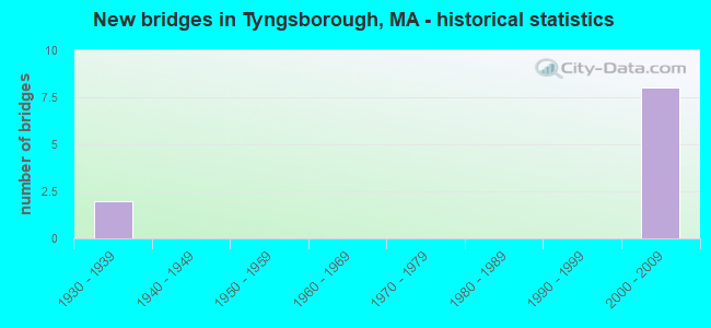
- New bridges - historical statistics
- 21930-1939
- 82000-2009


- Bridge Condition - Superstructure
- 10.0%Very good
- 60.0%Good
- 20.0%Satisfactory
- 10.0%Fair

- Bridge Condition - Substructure
- 80.0%Good
- 20.0%Satisfactory
Find on map >> Show street view
Structure Number: T090012ENDOTNBI, Location: JUST EAST OF MIDDLESEX RD (Lat: 42.676147, Lng: -71.421200), Route carried "on" structure: State highway 113, Year Built: 1930, Year Reconstructed: 2013, Status: Open, Structure Length: 18.00m (59.06ft), Average Daily Traffic: 31,000 (year 2019), Truck Traffic: 4%, Average Future Daily Traffic: 35,218 (year 2033), Design Load: HS 20, Features Intersected: WATER MERRIMACK RIVER
Minimum Vertical Clearance: 4.39m (14.40ft), Kilometerpoint: 117.892, Lanes on structure: 2, Owner: State Highway Agency, Approaching Roadway Width: 9.1m (29.9ft), Material/Design: Steel, Design/Construction: Arch - Thru, Number Of Spans In Main Unit: 1, Number Of Approach Spans: 1, Length of Maximum Span: 166.7m (546.9ft), Curb or Sidewalk Widths: Left: 0.0m, Right: 2.6m (8.5ft), Curb-To-Curb Width: 9.1m (29.9ft), Out-to-Out Width: 12.7m (41.7ft)
Condition: Deck: Good, Superstructure: Fair, Substructure: Satisfactory, Channel: Fair, Operating Rating: 38.9 metric tons, Method Used To Determine Operating Rating: Load Factor (LF), Inventory Rating: 32.9 metric tons, Method Used To Determine Inventory Rating: Load Factor (LF), Structural Evaluation: Somewhat better than minimum adequacy, Deck Geometry: Meets minimum limits, Waterway Adequacy: Better than present minimum criteria, Approach Roadway Alignment: Equal to present minimum criteria, Length Of Structure Improvement: 18.10m (59.38ft), Designated Inspection Frequency: Every 24 months, Critical Feature Inspection Frequency: Every 24 months, Inspection Date: July 2021, Critical Feature Inspection Date: July 2021, Bridge Improvement Cost: $9,030,000, Roadway Improvement Cost: $904,000, Total Project Cost: $13,546,000 ( Estimate for 2022), Deck Structure Type: Closed Grating, Wearing Surface/Protective System: Wearing Surface: Epoxy Overlay, Deck Protection: Epoxy Coated Reinforcing
Find on map >> Show street view
Structure Number: T090022EMDOTNBI, Location: AT TYNGSBOROUGH BRIDGE (Lat: 42.676208, Lng: -71.422369), Route carried "on" structure: State highway 113, Year Built: 1930, Year Reconstructed: 2012, Status: Open, Structure Length: 2.04m (6.69ft), Average Daily Traffic: 22,300 (year 2020), Truck Traffic: 10%, Average Future Daily Traffic: 16,741 (year 2033), Design Load: HS 20, Features Intersected: RR BMRR
Minimum Vertical Clearance: 30+ m (98+ ft), Kilometerpoint: 117.892, Lanes on structure: 2, Owner: State Highway Agency, Approaching Roadway Width: 9.1m (29.9ft), Material/Design: Steel, Design/Construction: Stringer/Multi-beam, Number Of Spans In Main Unit: 1, Length of Maximum Span: 18.0m (59.1ft), Curb or Sidewalk Widths: Left: 0.5m (1.6ft), Right: 2.3m (7.5ft), Curb-To-Curb Width: 9.1m (29.9ft), Out-to-Out Width: 12.8m (42.0ft)
Condition: Deck: Good, Superstructure: Very good, Substructure: Satisfactory, Operating Rating: 78.9 metric tons, Method Used To Determine Operating Rating: Load Factor (LF), Inventory Rating: 47.3 metric tons, Method Used To Determine Inventory Rating: Load Factor (LF), Structural Evaluation: Equal to present minimum criteria, Deck Geometry: High priority of corrective action, Underclear: High priority of corrective action, Approach Roadway Alignment: Equal to present desirable criteria, Length Of Structure Improvement: 2.10m (6.89ft), Designated Inspection Frequency: Every 24 months, Inspection Date: October 2020, Bridge Improvement Cost: $852,000, Roadway Improvement Cost: $86,000, Total Project Cost: $1,279,000 ( Estimate for 2022), Deck Structure Type: Concrete Cast-file-Place, Wearing Surface/Protective System: Wearing Surface: Bituminous, Membrane: Built-up, Deck Protection: Epoxy Coated Reinforcing
Find on map >> Show street view
Structure Number: T090108HKDOTNBI, Location: 5.3 MI S OF NH LINE (Lat: 42.658975, Lng: -71.428197), Route carried "on" structure: US 3, Year Built: 2004, Status: Open, Structure Length: 4.18m (13.71ft), Average Daily Traffic: 50,100 (year 2019), Truck Traffic: 10%, Average Future Daily Traffic: 68,779 (year 2032), Design Load: HS 25 or greater, Features Intersected: HWY WESTFORD RD
Minimum Vertical Clearance: 30+ m (98+ ft), Kilometerpoint: 145.706, Lanes on structure: 4, Lanes under structure: 4, Base Highway Network: Yes, Owner: State Highway Agency, Approaching Roadway Width: 28.8m (94.5ft), Skew: 12 degrees, Material/Design: Steel, Design/Construction: Stringer/Multi-beam, Number Of Spans In Main Unit: 1, Length of Maximum Span: 40.7m (133.5ft), Curb-To-Curb Width: 28.8m (94.5ft), Out-to-Out Width: 29.8m (97.8ft)
Condition: Deck: Good, Superstructure: Good, Substructure: Good, Operating Rating: 89.1 metric tons, Method Used To Determine Operating Rating: Load Factor (LF), Inventory Rating: 53.4 metric tons, Method Used To Determine Inventory Rating: Load Factor (LF), Structural Evaluation: Better than present minimum criteria, Deck Geometry: Superior to present desirable criteria, Underclear: Somewhat better than minimum adequacy, Approach Roadway Alignment: Equal to present desirable criteria, Length Of Structure Improvement: 4.20m (13.78ft), Designated Inspection Frequency: Every 24 months, Inspection Date: May 2021, Bridge Improvement Cost: $493,000, Roadway Improvement Cost: $50,000, Total Project Cost: $740,000 ( Estimate for 2022), Deck Structure Type: Concrete Cast-file-Place, Wearing Surface/Protective System: Wearing Surface: Integral Concrete, Deck Protection: Epoxy Coated Reinforcing
Find on map >> Show street view
Structure Number: T090108HLDOTNBI, Location: 3.3 MI S OF NH LINE (Lat: 42.658750, Lng: -71.428406), Route carried "on" structure: US 3, Year Built: 2004, Status: Open, Structure Length: 4.18m (13.71ft), Average Daily Traffic: 60,000 (year 2019), Truck Traffic: 10%, Average Future Daily Traffic: 68,779 (year 2032), Design Load: HS 25 or greater, Features Intersected: HWY WESTFORD RD
Minimum Vertical Clearance: 30+ m (98+ ft), Kilometerpoint: 145.706, Lanes on structure: 4, Lanes under structure: 4, Base Highway Network: Yes, Owner: State Highway Agency, Approaching Roadway Width: 22.6m (74.1ft), Skew: 12 degrees, Material/Design: Steel, Design/Construction: Stringer/Multi-beam, Number Of Spans In Main Unit: 1, Length of Maximum Span: 40.7m (133.5ft), Curb-To-Curb Width: 22.6m (74.1ft), Out-to-Out Width: 23.7m (77.8ft)
Condition: Deck: Good, Superstructure: Good, Substructure: Good, Operating Rating: 98.1 metric tons, Method Used To Determine Operating Rating: Load Factor (LF), Inventory Rating: 58.7 metric tons, Method Used To Determine Inventory Rating: Load Factor (LF), Structural Evaluation: Better than present minimum criteria, Deck Geometry: Superior to present desirable criteria, Underclear: Somewhat better than minimum adequacy, Approach Roadway Alignment: Equal to present desirable criteria, Length Of Structure Improvement: 4.20m (13.78ft), Designated Inspection Frequency: Every 24 months, Inspection Date: May 2021, Bridge Improvement Cost: $391,000, Roadway Improvement Cost: $40,000, Total Project Cost: $587,000 ( Estimate for 2022), Deck Structure Type: Concrete Cast-file-Place, Wearing Surface/Protective System: Wearing Surface: Integral Concrete, Deck Protection: Epoxy Coated Reinforcing
Find on map >> Show street view
Structure Number: T090118HHDOTNBI, Location: 1.5 MI. N OF RTE 40 (Lat: 42.651539, Lng: -71.422031), Route carried "on" structure: US 3, Year Built: 2004, Status: Open, Structure Length: 4.50m (14.76ft), Average Daily Traffic: 82,679 (year 2019), Truck Traffic: 10%, Average Future Daily Traffic: 123,027 (year 2032), Design Load: HS 25 or greater, Features Intersected: HWY DUNSTABLE RD
Minimum Vertical Clearance: 30+ m (98+ ft), Kilometerpoint: 136.791, Lanes on structure: 3, Lanes under structure: 2, Base Highway Network: Yes, Owner: State Highway Agency, Approaching Roadway Width: 22.0m (72.2ft), Skew: 15 degrees, Material/Design: Steel, Design/Construction: Stringer/Multi-beam, Number Of Spans In Main Unit: 1, Length of Maximum Span: 43.7m (143.4ft), Curb-To-Curb Width: 22.0m (72.2ft), Out-to-Out Width: 23.0m (75.5ft)
Condition: Deck: Good, Superstructure: Good, Substructure: Good, Inventory Rating: 60.4 metric tons, Method Used To Determine Inventory Rating: Load Factor (LF), Structural Evaluation: Better than present minimum criteria, Deck Geometry: Superior to present desirable criteria, Underclear: Somewhat better than minimum adequacy, Approach Roadway Alignment: Equal to present desirable criteria, Length Of Structure Improvement: 4.60m (15.09ft), Designated Inspection Frequency: Every 24 months, Inspection Date: May 2021, Bridge Improvement Cost: $416,000, Roadway Improvement Cost: $42,000, Total Project Cost: $625,000 ( Estimate for 2022), Deck Structure Type: Concrete Cast-file-Place, Wearing Surface/Protective System: Wearing Surface: Integral Concrete, Deck Protection: Epoxy Coated Reinforcing
Find on map >> Show street view
Structure Number: T090118HJDOTNBI, Location: 1.5 MI. N. OF RTE 40 (Lat: 42.651708, Lng: -71.422631), Route carried "on" structure: US 3, Year Built: 2004, Status: Open, Structure Length: 4.90m (16.08ft), Average Daily Traffic: 77,900 (year 2017), Truck Traffic: 10%, Average Future Daily Traffic: 123,027 (year 2032), Design Load: HS 25 or greater, Features Intersected: HWY DUNSTABLE RD
Minimum Vertical Clearance: 30+ m (98+ ft), Kilometerpoint: 136.791, Lanes on structure: 3, Lanes under structure: 2, Base Highway Network: Yes, Owner: State Highway Agency, Approaching Roadway Width: 22.0m (72.2ft), Skew: 15 degrees, Material/Design: Steel, Design/Construction: Stringer/Multi-beam, Number Of Spans In Main Unit: 1, Length of Maximum Span: 47.7m (156.5ft), Curb-To-Curb Width: 22.0m (72.2ft), Out-to-Out Width: 23.0m (75.5ft)
Condition: Deck: Good, Superstructure: Good, Substructure: Good, Inventory Rating: 60.4 metric tons, Method Used To Determine Inventory Rating: Load Factor (LF), Structural Evaluation: Better than present minimum criteria, Deck Geometry: Superior to present desirable criteria, Underclear: Somewhat better than minimum adequacy, Approach Roadway Alignment: Equal to present desirable criteria, Length Of Structure Improvement: 5.00m (16.40ft), Designated Inspection Frequency: Every 24 months, Inspection Date: May 2021, Bridge Improvement Cost: $452,000, Roadway Improvement Cost: $46,000, Total Project Cost: $679,000 ( Estimate for 2022), Deck Structure Type: Concrete Cast-file-Place, Wearing Surface/Protective System: Wearing Surface: Integral Concrete, Deck Protection: Epoxy Coated Reinforcing
Find on map >> Show street view
Structure Number: T09014AYDDOTNBI, Location: RT 113 AT RT 3 (Lat: 42.680344, Lng: -71.441225), Route carried "on" structure: State highway 113, Year Built: 2004, Status: Open, Structure Length: 9.06m (29.72ft), Average Daily Traffic: 13,448 (year 2019), Truck Traffic: 6%, Average Future Daily Traffic: 28,743 (year 2032), Design Load: HS 25 or greater, Features Intersected: US 3
Minimum Vertical Clearance: 30+ m (98+ ft), Kilometerpoint: 18.298, Lanes on structure: 4, Lanes under structure: 8, Owner: State Highway Agency, Approaching Roadway Width: 20.0m (65.6ft), Skew: 4 degrees, Material/Design: Steel continuous, Design/Construction: Stringer/Multi-beam, Number Of Spans In Main Unit: 2, Length of Maximum Span: 44.3m (145.3ft), Curb or Sidewalk Widths: Left: 1.7m (5.6ft), Right: 0.1m (0.3ft), Curb-To-Curb Width: 20.0m (65.6ft), Out-to-Out Width: 22.5m (73.8ft)
Condition: Deck: Good, Superstructure: Satisfactory, Substructure: Good, Operating Rating: 87.6 metric tons, Method Used To Determine Operating Rating: Load Factor (LF), Inventory Rating: 52.5 metric tons, Method Used To Determine Inventory Rating: Load Factor (LF), Structural Evaluation: Equal to present minimum criteria, Deck Geometry: Better than present minimum criteria, Underclear: Equal to present minimum criteria, Approach Roadway Alignment: Equal to present desirable criteria, Length Of Structure Improvement: 9.10m (29.86ft), Designated Inspection Frequency: Every 24 months, Inspection Date: May 2021, Bridge Improvement Cost: $1,802,000, Roadway Improvement Cost: $181,000, Total Project Cost: $2,704,000 ( Estimate for 2022), Deck Structure Type: Concrete Cast-file-Place, Wearing Surface/Protective System: Wearing Surface: Integral Concrete, Deck Protection: Epoxy Coated Reinforcing
Find on map >> Show street view
Structure Number: T090216G9DOTNBI, Location: 1.1 MI S NEW HAMP. LINE (Lat: 42.685906, Lng: -71.442539), Route carried "on" structure: City street , Year Built: 2004, Status: Open, Structure Length: 7.34m (24.08ft), Average Daily Traffic: 3,491 (year 2019), Truck Traffic: 7%, Average Future Daily Traffic: 3,332 (year 2032), Design Load: HS 25 or greater, Features Intersected: US 3, Facility Carried by Structure: HWY LOCUST AVE
Minimum Vertical Clearance: 30+ m (98+ ft), Kilometerpoint: 0.000, Lanes on structure: 2, Lanes under structure: 6, Base Highway Network: Yes, Owner: State Highway Agency, Approaching Roadway Width: 10.2m (33.5ft), Skew: 2 degrees, Material/Design: Steel continuous, Design/Construction: Stringer/Multi-beam, Number Of Spans In Main Unit: 2, Length of Maximum Span: 35.8m (117.5ft), Curb or Sidewalk Widths: Left: 0.0m, Right: 1.6m (5.2ft), Curb-To-Curb Width: 10.2m (33.5ft), Out-to-Out Width: 12.8m (42.0ft)
Condition: Deck: Good, Superstructure: Satisfactory, Substructure: Good, Operating Rating: 97.0 metric tons, Method Used To Determine Operating Rating: Load Factor (LF), Inventory Rating: 58.1 metric tons, Method Used To Determine Inventory Rating: Load Factor (LF), Structural Evaluation: Equal to present minimum criteria, Deck Geometry: Meets minimum limits, Approach Roadway Alignment: Equal to present desirable criteria, Length Of Structure Improvement: 7.40m (24.28ft), Designated Inspection Frequency: Every 24 months, Inspection Date: May 2021, Bridge Improvement Cost: $2,233,000, Roadway Improvement Cost: $224,000, Total Project Cost: $3,350,000 ( Estimate for 2022), Deck Structure Type: Concrete Cast-file-Place, Wearing Surface/Protective System: Wearing Surface: Integral Concrete, Deck Protection: Epoxy Coated Reinforcing
Find on map >> Show street view
Structure Number: T0902284YDOTNBI, Location: 0.25 M SLY N.H. LINE (Lat: 42.697592, Lng: -71.447703), Route carried "on" structure: US 3, Year Built: 2004, Status: Open, Structure Length: 3.74m (12.27ft), Average Daily Traffic: 48,000 (year 2018), Truck Traffic: 10%, Average Future Daily Traffic: 67,910 (year 2032), Design Load: HS 25 or greater, Features Intersected: US 3 SB CONNECTOR
Minimum Vertical Clearance: 30+ m (98+ ft), Kilometerpoint: 0.000, Lanes on structure: 3, Lanes under structure: 1, Base Highway Network: Yes, Owner: State Highway Agency, Approaching Roadway Width: 23.1m (75.8ft), Skew: 4 degrees, Material/Design: Steel, Design/Construction: Stringer/Multi-beam, Number Of Spans In Main Unit: 1, Length of Maximum Span: 36.9m (121.1ft), Curb-To-Curb Width: 23.1m (75.8ft), Out-to-Out Width: 24.2m (79.4ft)
Condition: Deck: Good, Superstructure: Good, Substructure: Good, Operating Rating: 97.1 metric tons, Method Used To Determine Operating Rating: Load Factor (LF), Inventory Rating: 58.2 metric tons, Method Used To Determine Inventory Rating: Load Factor (LF), Structural Evaluation: Better than present minimum criteria, Deck Geometry: Superior to present desirable criteria, Underclear: High priority of corrective action, Approach Roadway Alignment: Equal to present desirable criteria, Length Of Structure Improvement: 3.80m (12.47ft), Designated Inspection Frequency: Every 24 months, Inspection Date: May 2021, Bridge Improvement Cost: $362,000, Roadway Improvement Cost: $37,000, Total Project Cost: $544,000 ( Estimate for 2022), Deck Structure Type: Concrete Cast-file-Place, Wearing Surface/Protective System: Wearing Surface: Monolithic Concrete, Deck Protection: Epoxy Coated Reinforcing
Find on map >> Show street view
Structure Number: T09022854DOTNBI, Location: 0.25 MI SLY NH LINE (Lat: 42.697242, Lng: -71.447872), Route carried "on" structure: US 3, Year Built: 2004, Status: Open, Structure Length: 4.19m (13.75ft), Average Daily Traffic: 42,200 (year 2018), Truck Traffic: 10%, Average Future Daily Traffic: 67,910 (year 2032), Design Load: HS 25 or greater, Features Intersected: US 3 SB CONNECTOR
Minimum Vertical Clearance: 30+ m (98+ ft), Kilometerpoint: 0.000, Lanes on structure: 3, Lanes under structure: 1, Base Highway Network: Yes, Owner: State Highway Agency, Approaching Roadway Width: 22.9m (75.1ft), Skew: 4 degrees, Material/Design: Steel, Design/Construction: Stringer/Multi-beam, Number Of Spans In Main Unit: 1, Length of Maximum Span: 40.3m (132.2ft), Curb-To-Curb Width: 23.0m (75.5ft), Out-to-Out Width: 24.0m (78.7ft)
Condition: Deck: Good, Superstructure: Good, Substructure: Good, Operating Rating: 97.6 metric tons, Method Used To Determine Operating Rating: Load Factor (LF), Inventory Rating: 58.5 metric tons, Method Used To Determine Inventory Rating: Load Factor (LF), Structural Evaluation: Better than present minimum criteria, Deck Geometry: Superior to present desirable criteria, Underclear: Meets minimum limits, Approach Roadway Alignment: Equal to present desirable criteria, Length Of Structure Improvement: 4.20m (13.78ft), Designated Inspection Frequency: Every 24 months, Inspection Date: May 2021, Bridge Improvement Cost: $397,000, Roadway Improvement Cost: $40,000, Total Project Cost: $596,000 ( Estimate for 2022), Deck Structure Type: Concrete Cast-file-Place, Wearing Surface/Protective System: Wearing Surface: Monolithic Concrete, Deck Protection: Epoxy Coated Reinforcing