Bridge Statistics for Upton, Massachusetts (MA)
Condition, Traffic, Stress, Structural Evaluation, Project Costs
- National Bridge Inventory (NBI) Statistics
- 11Number of bridges
- 49ft / 15.0mTotal length
- $9,495,000Total costs
- 84,700Total average daily traffic
- 1,767Total average daily truck traffic
- National Bridge Inventory (NBI) Registered Bridges for Upton
- No street view available for this location
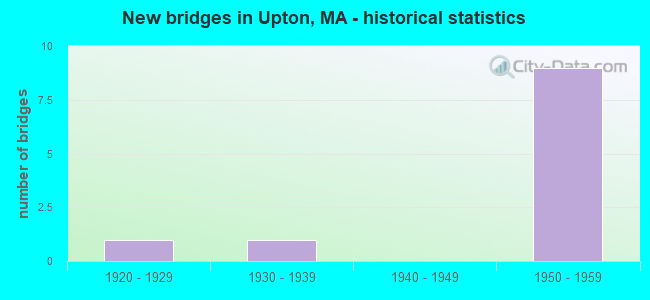
- New bridges - historical statistics
- 11920-1929
- 11930-1939
- 91950-1959

- Reconstructed bridges - Historical Statistics
- 11940-1949
- 01950-1959
- 01960-1969
- 01970-1979
- 01980-1989
- 11990-1999


- Bridge Condition - Deck
- 22.2%Good
- 44.4%Satisfactory
- 33.3%Fair

- Bridge Condition - Superstructure
- 22.2%Good
- 33.3%Satisfactory
- 44.4%Fair

- Bridge Condition - Substructure
- 33.3%Good
- 55.6%Satisfactory
- 11.1%Fair

- Bridge Condition - Channel
- 12.5%Good
- 87.5%Satisfactory
Find on map >> Show street view
Structure Number: U010011HWMUNNBI, Location: .8 MI SW OF MENDON ST (Lat: 42.149858, Lng: -71.615800), Route carried "on" structure: City street , Year Built: 1959, Status: Open, Structure Length: 2.35m (7.71ft), Average Daily Traffic: 800 (year 2015), Truck Traffic: 3%, Average Future Daily Traffic: 1,263 (year 2032), Features Intersected: WATER WEST RIVER, Facility Carried by Structure: HWY WEST RIV ST
Minimum Vertical Clearance: 30+ m (98+ ft), Kilometerpoint: 1.835, Lanes on structure: 2, Owner: Town or Township Highway Agency, Approaching Roadway Width: 6.7m (22.0ft), Skew: 1 degrees, Material/Design: Steel, Design/Construction: Stringer/Multi-beam, Number Of Spans In Main Unit: 1, Length of Maximum Span: 21.9m (71.9ft), Curb or Sidewalk Widths: Left: 0.7m (2.3ft), Right: 0.2m (0.7ft), Curb-To-Curb Width: 7.3m (24.0ft), Out-to-Out Width: 9.0m (29.5ft)
Condition: Deck: Good, Superstructure: Satisfactory, Substructure: Good, Channel: Good, Operating Rating: 45.3 metric tons, Method Used To Determine Operating Rating: Load Factor (LF), Inventory Rating: 24.1 metric tons, Method Used To Determine Inventory Rating: Load Factor (LF), Structural Evaluation: Equal to present minimum criteria, Deck Geometry: Meets minimum limits, Waterway Adequacy: Better than present minimum criteria, Approach Roadway Alignment: Equal to present minimum criteria, Length Of Structure Improvement: 2.40m (7.87ft), Designated Inspection Frequency: Every 24 months, Inspection Date: August 2021, Bridge Improvement Cost: $849,000, Roadway Improvement Cost: $85,000, Total Project Cost: $1,274,000 ( Estimate for 2022), Deck Structure Type: Concrete Cast-file-Place, Wearing Surface/Protective System: Wearing Surface: Bituminous
Find on map >> Show street view
Structure Number: U010051DJMUNNBI, Location: .2 MI. W. OF MAPLE AVE. (Lat: 42.157089, Lng: -71.622325), Route carried "on" structure: City street , Year Built: 1959, Status: Posted for load, Structure Length: 1.98m (6.50ft), Average Daily Traffic: 10,300 (year 2019), Truck Traffic: 7%, Average Future Daily Traffic: 31,586 (year 2032), Features Intersected: WATER WEST RIVER, Facility Carried by Structure: HWY PLEASANT ST
Minimum Vertical Clearance: 30+ m (98+ ft), Kilometerpoint: 2.076, Lanes on structure: 2, Owner: Town or Township Highway Agency, Approaching Roadway Width: 8.5m (27.9ft), Skew: 3 degrees, Material/Design: Steel, Design/Construction: Stringer/Multi-beam, Number Of Spans In Main Unit: 1, Length of Maximum Span: 18.3m (60.0ft), Curb or Sidewalk Widths: Left: 0.0m, Right: 0.8m (2.6ft), Curb-To-Curb Width: 8.5m (27.9ft), Out-to-Out Width: 10.3m (33.8ft)
Condition: Deck: Satisfactory, Superstructure: Satisfactory, Substructure: Good, Channel: Satisfactory, Operating Rating: 39.7 metric tons, Method Used To Determine Operating Rating: Load Factor (LF), Inventory Rating: 23.8 metric tons, Method Used To Determine Inventory Rating: Load Factor (LF), Structural Evaluation: Somewhat better than minimum adequacy, Deck Geometry: High priority of replacement, Waterway Adequacy: Better than present minimum criteria, Approach Roadway Alignment: Equal to present desirable criteria, Length Of Structure Improvement: 2.00m (6.56ft), Designated Inspection Frequency: Every 24 months, Inspection Date: December 2021, Bridge Improvement Cost: $810,000, Roadway Improvement Cost: $82,000, Total Project Cost: $1,216,000 ( Estimate for 2022), Deck Structure Type: Concrete Cast-file-Place, Wearing Surface/Protective System: Wearing Surface: Bituminous, Membrane: Built-up
Find on map >> Show street view
Structure Number: U010061HXMUNNBI, Location: 500 FT E OF GLEN AVE (Lat: 42.167003, Lng: -71.627431), Route carried "on" structure: City street , Year Built: 1956, Status: Open, Structure Length: 0.70m (2.30ft), Average Daily Traffic: 490 (year 2001), Truck Traffic: 1%, Average Future Daily Traffic: 948 (year 2032), Design Load: H 15, Features Intersected: WATER WEST RIVER, Facility Carried by Structure: HWY HARTFORD AVE
Minimum Vertical Clearance: 30+ m (98+ ft), Kilometerpoint: 0.692, Lanes on structure: 2, Owner: Town or Township Highway Agency, Approaching Roadway Width: 7.6m (24.9ft), Material/Design: Prestressed concrete, Design/Construction: Slab, Number Of Spans In Main Unit: 1, Length of Maximum Span: 6.7m (22.0ft), Curb or Sidewalk Widths: Left: 0.3m (1.0ft), Right: 0.3m (1.0ft), Curb-To-Curb Width: 7.9m (25.9ft), Out-to-Out Width: 8.5m (27.9ft)
Condition: Deck: Satisfactory, Superstructure: Satisfactory, Substructure: Satisfactory, Channel: Satisfactory, Inventory Rating: 59.7 metric tons, Method Used To Determine Inventory Rating: Allowable Stress (AS), Structural Evaluation: Equal to present minimum criteria, Deck Geometry: Somewhat better than minimum adequacy, Waterway Adequacy: Equal to present minimum criteria, Approach Roadway Alignment: Better than present minimum criteria, Length Of Structure Improvement: 0.80m (2.62ft), Designated Inspection Frequency: Every 24 months, Underwater Inspection Frequency: Every 36 months, Inspection Date: September 2020, Underwater Inspection Date: April 2019, Bridge Improvement Cost: $325,000, Roadway Improvement Cost: $33,000, Total Project Cost: $488,000 ( Estimate for 2022), Deck Structure Type: Concrete Precast Panels, Wearing Surface/Protective System: Wearing Surface: Bituminous, Membrane: Built-up
Find on map >> Show street view
Structure Number: U010101HYMUNNBI, Location: 0.5M N OF RT140VIA MECNIC (Lat: 42.182750, Lng: -71.628003), Route carried "on" structure: City street , Year Built: 1956, Status: Open, Structure Length: 0.67m (2.20ft), Average Daily Traffic: 300 (year 2018), Truck Traffic: 1%, Average Future Daily Traffic: 474 (year 2031), Design Load: H 15, Features Intersected: WATER WARREN BROOK, Facility Carried by Structure: HWY FOWLER ST
Minimum Vertical Clearance: 4.32m (14.17ft), Kilometerpoint: 0.129, Lanes on structure: 2, Owner: Town or Township Highway Agency, Approaching Roadway Width: 6.7m (22.0ft), Material/Design: Prestressed concrete, Design/Construction: Slab, Number Of Spans In Main Unit: 1, Length of Maximum Span: 6.0m (19.7ft), Curb or Sidewalk Widths: Left: 0.3m (1.0ft), Right: 0.3m (1.0ft), Curb-To-Curb Width: 6.7m (22.0ft), Out-to-Out Width: 7.3m (24.0ft)
Condition: Deck: Fair, Superstructure: Fair, Substructure: Satisfactory, Channel: Satisfactory, Operating Rating: 71.6 metric tons, Method Used To Determine Operating Rating: Load Factor (LF), Inventory Rating: 54.8 metric tons, Method Used To Determine Inventory Rating: Load Factor (LF), Structural Evaluation: Somewhat better than minimum adequacy, Deck Geometry: Meets minimum limits, Waterway Adequacy: Equal to present minimum criteria, Approach Roadway Alignment: Equal to present minimum criteria, Length Of Structure Improvement: 0.70m (2.30ft), Designated Inspection Frequency: Every 24 months, Underwater Inspection Frequency: Every 36 months, Inspection Date: August 2020, Underwater Inspection Date: Febuary 2022, Bridge Improvement Cost: $201,000, Roadway Improvement Cost: $21,000, Total Project Cost: $302,000 ( Estimate for 2022), Deck Structure Type: Concrete Precast Panels, Wearing Surface/Protective System: Wearing Surface: Bituminous, Membrane: Built-up
Find on map >> Show street view
Structure Number: U010121LXDOTNBI, Location: 130 FT S OF MECHANIC ST (Lat: 42.172592, Lng: -71.627933), Route carried "on" structure: State highway 140, Year Built: 1928, Year Reconstructed: 1952, Status: Open, Structure Length: 0.88m (2.89ft), Average Daily Traffic: 10,688 (year 2018), Truck Traffic: 7%, Average Future Daily Traffic: 14,214 (year 2033), Design Load: H 20, Features Intersected: WATER WARREN BROOK
Minimum Vertical Clearance: 30+ m (98+ ft), Kilometerpoint: 101.707, Lanes on structure: 2, Base Highway Network: Yes, Owner: State Highway Agency, Approaching Roadway Width: 12.2m (40.0ft), Skew: 2 degrees, Material/Design: Concrete, Design/Construction: Tee Beam, Number Of Spans In Main Unit: 1, Length of Maximum Span: 7.6m (24.9ft), Curb or Sidewalk Widths: Left: 1.5m (4.9ft), Right: 1.5m (4.9ft), Curb-To-Curb Width: 12.2m (40.0ft), Out-to-Out Width: 16.1m (52.8ft)
Condition: Deck: Fair, Superstructure: Fair, Substructure: Fair, Channel: Satisfactory, Operating Rating: 34.4 metric tons, Method Used To Determine Operating Rating: Load Factor (LF), Inventory Rating: 26.6 metric tons, Method Used To Determine Inventory Rating: Load Factor (LF), Structural Evaluation: Somewhat better than minimum adequacy, Deck Geometry: Somewhat better than minimum adequacy, Waterway Adequacy: Equal to present desirable criteria, Approach Roadway Alignment: Equal to present desirable criteria, Length Of Structure Improvement: 0.90m (2.95ft), Designated Inspection Frequency: Every 24 months, Underwater Inspection Frequency: Every 48 months, Inspection Date: Febuary 2022, Underwater Inspection Date: April 2018, Bridge Improvement Cost: $570,000, Roadway Improvement Cost: $58,000, Total Project Cost: $856,000 ( Estimate for 2022), Deck Structure Type: Concrete Cast-file-Place, Wearing Surface/Protective System: Wearing Surface: Bituminous
Find on map >> Show street view
Structure Number: U010131J0MUNNBI, Location: 200 FT.SOUTH OF ST.140 (Lat: 42.172283, Lng: -71.628708), Route carried "on" structure: City street , Year Built: 1937, Status: Posted for load, Structure Length: 0.98m (3.22ft), Average Daily Traffic: 500 (year 2021), Truck Traffic: 1%, Average Future Daily Traffic: 790 (year 2032), Design Load: H 15, Features Intersected: WATER WEST RIVER, Facility Carried by Structure: HWY GLEN AVE
Minimum Vertical Clearance: 30+ m (98+ ft), Kilometerpoint: 2.140, Lanes on structure: 2, Owner: Town or Township Highway Agency, Approaching Roadway Width: 7.3m (24.0ft), Skew: 2 degrees, Material/Design: Steel, Design/Construction: Stringer/Multi-beam, Number Of Spans In Main Unit: 1, Length of Maximum Span: 7.7m (25.3ft), Curb or Sidewalk Widths: Left: 0.2m (0.7ft), Right: 0.2m (0.7ft), Curb-To-Curb Width: 7.3m (24.0ft), Out-to-Out Width: 8.3m (27.2ft)
Condition: Deck: Fair, Superstructure: Fair, Substructure: Satisfactory, Channel: Satisfactory, Operating Rating: 19.2 metric tons, Method Used To Determine Operating Rating: Load Factor (LF), Inventory Rating: 11.5 metric tons, Method Used To Determine Inventory Rating: Load Factor (LF), Structural Evaluation: Meets minimum limits, Deck Geometry: Meets minimum limits, Waterway Adequacy: Equal to present minimum criteria, Approach Roadway Alignment: Equal to present minimum criteria, Bridge Posting: Required (Relationship of Operating Rating to Maximum Legal Load: > 39.9% below), Length Of Structure Improvement: 1.00m (3.28ft), Designated Inspection Frequency: Every 24 months, Inspection Date: October 2021, Bridge Improvement Cost: $327,000, Roadway Improvement Cost: $33,000, Total Project Cost: $491,000 ( Estimate for 2022), Deck Structure Type: Concrete Cast-file-Place, Wearing Surface/Protective System: Wearing Surface: Bituminous
Find on map >> Show street view
Structure Number: U0101523WDOTNBI, Location: 50 FT.WST. OF ST.140 (Lat: 42.173389, Lng: -71.630472), Route carried "on" structure: Other road , Year Built: 1952, Status: Open, Structure Length: 0.70m (2.30ft), Average Daily Traffic: 3,436 (year 2020), Truck Traffic: 7%, Average Future Daily Traffic: 6,949 (year 2032), Design Load: H 20, Features Intersected: WATER WEST RIVER, Facility Carried by Structure: HWY WILLIAMS ST
Minimum Vertical Clearance: 30+ m (98+ ft), Kilometerpoint: 0.161, Lanes on structure: 2, Owner: State Highway Agency, Approaching Roadway Width: 9.1m (29.9ft), Skew: 2 degrees, Material/Design: Concrete, Design/Construction: Tee Beam, Number Of Spans In Main Unit: 1, Length of Maximum Span: 6.1m (20.0ft), Curb or Sidewalk Widths: Left: 1.6m (5.2ft), Right: 0.0m, Curb-To-Curb Width: 9.2m (30.2ft), Out-to-Out Width: 11.6m (38.1ft)
Condition: Deck: Satisfactory, Superstructure: Good, Substructure: Satisfactory, Channel: Satisfactory, Operating Rating: 43.4 metric tons, Method Used To Determine Operating Rating: Load and Resistance Factor (LRFR), Inventory Rating: 26.0 metric tons, Method Used To Determine Inventory Rating: Load and Resistance Factor (LRFR), Structural Evaluation: Equal to present minimum criteria, Deck Geometry: Meets minimum limits, Waterway Adequacy: Equal to present desirable criteria, Approach Roadway Alignment: Better than present minimum criteria, Length Of Structure Improvement: 0.80m (2.62ft), Designated Inspection Frequency: Every 24 months, Underwater Inspection Frequency: Every 40 months, Inspection Date: May 2021, Underwater Inspection Date: July 2019, Bridge Improvement Cost: $365,000, Roadway Improvement Cost: $37,000, Total Project Cost: $548,000 ( Estimate for 2022), Deck Structure Type: Concrete Cast-file-Place, Wearing Surface/Protective System: Wearing Surface: Bituminous, Membrane: Built-up
Find on map >> Show street view
Structure Number: U010191J1MUNNBI, Location: .3 MILES SOUTH OF ST 140 (Lat: 42.167878, Lng: -71.602667), Route carried "on" structure: City street , Year Built: 1956, Status: Open, Structure Length: 0.69m (2.26ft), Average Daily Traffic: 300 (year 2014), Truck Traffic: 1%, Average Future Daily Traffic: 474 (year 2031), Design Load: H 15, Features Intersected: WATER CENTER BROOK, Facility Carried by Structure: HWY STATION ST
Minimum Vertical Clearance: 30+ m (98+ ft), Kilometerpoint: 0.451, Lanes on structure: 2, Owner: Town or Township Highway Agency, Approaching Roadway Width: 5.5m (18.0ft), Material/Design: Prestressed concrete, Design/Construction: Slab, Number Of Spans In Main Unit: 1, Length of Maximum Span: 6.1m (20.0ft), Curb or Sidewalk Widths: Left: 0.2m (0.7ft), Right: 0.2m (0.7ft), Curb-To-Curb Width: 5.5m (18.0ft), Out-to-Out Width: 6.1m (20.0ft)
Condition: Deck: Good, Superstructure: Good, Substructure: Good, Channel: Satisfactory, Inventory Rating: 81.5 metric tons, Method Used To Determine Inventory Rating: Load Factor (LF), Structural Evaluation: Better than present minimum criteria, Deck Geometry: High priority of corrective action, Waterway Adequacy: Better than present minimum criteria, Approach Roadway Alignment: Equal to present minimum criteria, Length Of Structure Improvement: 0.70m (2.30ft), Designated Inspection Frequency: Every 24 months, Inspection Date: April 2020, Bridge Improvement Cost: $363,000, Roadway Improvement Cost: $37,000, Total Project Cost: $545,000 ( Estimate for 2022), Deck Structure Type: Concrete Precast Panels, Wearing Surface/Protective System: Wearing Surface: Bituminous, Membrane: Built-up
Find on map >> Show street view
Structure Number: U010204N7DOTNBI, Location: I-90 MM 102.5 (Lat: 42.228692, Lng: -71.621106), Route carried "on" structure: Interstate 90, Year Built: 1957, Year Reconstructed: 1995, Status: Open, Structure Length: 6.07m (19.91ft), Average Daily Traffic: 1,949 (year 2017), Truck Traffic: 1%, Average Future Daily Traffic: 158 (year 2031), Design Load: HS 20, Features Intersected: I 90, Facility Carried by Structure: HWY NORTH ST
Minimum Vertical Clearance: 30+ m (98+ ft), Kilometerpoint: 164.953, Lanes on structure: 2, Lanes under structure: 6, Owner: State Highway Agency, Approaching Roadway Width: 7.3m (24.0ft), Material/Design: Steel continuous, Design/Construction: Stringer/Multi-beam, Number Of Spans In Main Unit: 2, Number Of Approach Spans: 2, Length of Maximum Span: 19.2m (63.0ft), Curb or Sidewalk Widths: Left: 1.5m (4.9ft), Right: 0.8m (2.6ft), Curb-To-Curb Width: 7.3m (24.0ft), Out-to-Out Width: 10.5m (34.4ft)
Condition: Deck: Satisfactory, Superstructure: Fair, Substructure: Satisfactory, Operating Rating: 45.7 metric tons, Method Used To Determine Operating Rating: Load Factor (LF), Inventory Rating: 27.4 metric tons, Method Used To Determine Inventory Rating: Load Factor (LF), Structural Evaluation: Somewhat better than minimum adequacy, Deck Geometry: Meets minimum limits, Underclear: High priority of corrective action, Approach Roadway Alignment: Equal to present desirable criteria, Length Of Structure Improvement: 6.10m (20.01ft), Designated Inspection Frequency: Every 24 months, Inspection Date: August 2020, Bridge Improvement Cost: $2,516,000, Roadway Improvement Cost: $252,000, Total Project Cost: $3,775,000 ( Estimate for 2022), Deck Structure Type: Concrete Cast-file-Place, Wearing Surface/Protective System: Wearing Surface: Bituminous, Membrane: Built-up, Deck Protection: Epoxy Coated Reinforcing
Find on map >> Show street view
Structure Number: U010204N7DOTNBI, Location: AT MILE 102.5 (Lat: 42.233333, Lng: -71.616667), Route carried "under" structure: Interstate 90, Year Built: 1957, Structure Length: 0. m, Average Daily Traffic: 28,011 (year 0000), Features Intersected: I 90 WB, Facility Carried by Structure: HWY NORTH ST
Minimum Vertical Clearance: 4.27m (14.01ft), Kilometerpoint: 164.953, Lanes on structure: 2, Lanes under structure: 3, Toll: On toll road, Material/Design: Steel, Design/Construction: Stringer/Multi-beam, Length of Maximum Span: 19.2m (63.0ft)
Find on map >> Show street view
Structure Number: U010204N7DOTNBI, Location: AT MILE 102.5 (Lat: 42.233333, Lng: -71.616667), Route carried "under" structure: Interstate 90, Year Built: 1957, Structure Length: 0. m, Average Daily Traffic: 27,926 (year 0000), Features Intersected: I 90 EB, Facility Carried by Structure: HWY NORTH ST
Minimum Vertical Clearance: 4.27m (14.01ft), Kilometerpoint: 164.953, Lanes on structure: 2, Lanes under structure: 3, Toll: On toll road, Material/Design: Steel, Design/Construction: Stringer/Multi-beam, Length of Maximum Span: 19.2m (63.0ft)