Bridge Statistics for Wakefield, Massachusetts (MA)
Condition, Traffic, Stress, Structural Evaluation, Project Costs
- National Bridge Inventory (NBI) Statistics
- 13Number of bridges
- 95ft / 29.1mTotal length
- $52,684,000Total costs
- 1,067,539Total average daily traffic
- 76,638Total average daily truck traffic
- 1,597,085Total future (year 2031) average daily traffic
- National Bridge Inventory (NBI) Registered Bridges for Wakefield
- No street view available for this location
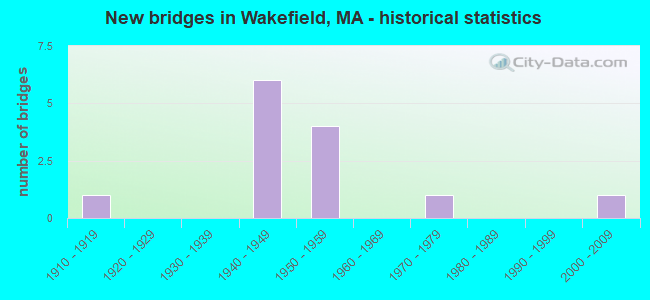
- New bridges - historical statistics
- 11910-1919
- 61940-1949
- 41950-1959
- 11970-1979
- 12000-2009

- Reconstructed bridges - Historical Statistics
- 51950-1959
- 11960-1969
- 01970-1979
- 21980-1989
- 11990-1999


- Bridge Condition - Deck
- 30.0%Good
- 20.0%Satisfactory
- 50.0%Fair

- Bridge Condition - Superstructure
- 27.3%Good
- 54.5%Satisfactory
- 18.2%Fair

- Bridge Condition - Substructure
- 18.2%Good
- 63.6%Satisfactory
- 18.2%Fair

- Bridge Condition - Culverts
- 50.0%Good
- 50.0%Fair
Find on map >> Show street view
Structure Number: B110112TYDOTNBI, Location: 0.3 MI E OF ST-97/1A (Lat: 42.575333, Lng: -70.885033), Route carried "on" structure: State highway 128, Year Built: 1948, Year Reconstructed: 1987, Status: Open, Structure Length: 3.63m (11.91ft), Average Daily Traffic: 72,449 (year 2018), Truck Traffic: 6%, Average Future Daily Traffic: 72,427 (year 2032), Design Load: HS 20, Features Intersected: COMB MBTA & TOZER RD
Minimum Vertical Clearance: 30+ m (98+ ft), Kilometerpoint: 82.155, Lanes on structure: 6, Lanes under structure: 2, Base Highway Network: Yes, Owner: State Highway Agency, Approaching Roadway Width: 26.5m (86.9ft), Skew: 20 degrees, Material/Design: Steel continuous, Design/Construction: Stringer/Multi-beam, Number Of Spans In Main Unit: 3, Length of Maximum Span: 13.7m (44.9ft), Curb or Sidewalk Widths: Left: 1.5m (4.9ft), Right: 1.5m (4.9ft), Curb-To-Curb Width: 26.5m (86.9ft), Out-to-Out Width: 31.1m (102.0ft)
Condition: Deck: Fair, Superstructure: Satisfactory, Substructure: Satisfactory, Operating Rating: 51.1 metric tons, Method Used To Determine Operating Rating: Load Factor (LF), Inventory Rating: 30.6 metric tons, Method Used To Determine Inventory Rating: Load Factor (LF), Structural Evaluation: Equal to present minimum criteria, Deck Geometry: Somewhat better than minimum adequacy, Underclear: High priority of corrective action, Approach Roadway Alignment: Equal to present desirable criteria, Length Of Structure Improvement: 3.70m (12.14ft), Designated Inspection Frequency: Every 24 months, Inspection Date: October 2021, Bridge Improvement Cost: $4,520,000, Roadway Improvement Cost: $453,000, Total Project Cost: $6,781,000 ( Estimate for 2022), Deck Structure Type: Concrete Cast-file-Place, Wearing Surface/Protective System: Wearing Surface: Bituminous, Membrane: Built-up, Deck Protection: Epoxy Coated Reinforcing
Find on map >> Show street view
Structure Number: B11013309DOTNBI, Location: 0.2 MI E OF BRIMBAL (Lat: 42.573347, Lng: -70.855889), Route carried "on" structure: State highway 22, Year Built: 1948, Year Reconstructed: 1985, Status: Open, Structure Length: 3.40m (11.15ft), Average Daily Traffic: 20,200 (year 2017), Truck Traffic: 5%, Average Future Daily Traffic: 14,056 (year 2032), Design Load: H 20, Features Intersected: ST128
Minimum Vertical Clearance: 30+ m (98+ ft), Kilometerpoint: 4.522, Lanes on structure: 3, Lanes under structure: 6, Owner: State Highway Agency, Approaching Roadway Width: 12.2m (40.0ft), Skew: 2 degrees, Material/Design: Steel continuous, Design/Construction: Stringer/Multi-beam, Number Of Spans In Main Unit: 2, Length of Maximum Span: 17.1m (56.1ft), Curb or Sidewalk Widths: Left: 0.0m, Right: 1.8m (5.9ft), Curb-To-Curb Width: 12.2m (40.0ft), Out-to-Out Width: 15.6m (51.2ft)
Condition: Deck: Fair, Superstructure: Fair, Substructure: Satisfactory, Operating Rating: 66.1 metric tons, Method Used To Determine Operating Rating: Load Factor (LF), Inventory Rating: 39.5 metric tons, Method Used To Determine Inventory Rating: Load Factor (LF), Structural Evaluation: Somewhat better than minimum adequacy, Deck Geometry: Meets minimum limits, Underclear: Meets minimum limits, Approach Roadway Alignment: Equal to present minimum criteria, Length Of Structure Improvement: 3.50m (11.48ft), Designated Inspection Frequency: Every 24 months, Inspection Date: November 2021, Bridge Improvement Cost: $2,145,000, Roadway Improvement Cost: $215,000, Total Project Cost: $3,218,000 ( Estimate for 2022), Deck Structure Type: Concrete Cast-file-Place, Wearing Surface/Protective System: Wearing Surface: Monolithic Concrete
Find on map >> Show street view
Structure Number: W01001AL9DOT634, Location: JUST OFF MAIN ST (Lat: 42.489844, Lng: -71.069450), Route carried "on" structure: City street , Year Built: 2001, Status: Open, Structure Length: 1.40m (4.59ft), Average Daily Traffic: 1,422 (year 2019), Average Future Daily Traffic: 2,211 (year 2032), Design Load: HS 20, Features Intersected: RR MBTA/BMRR, Facility Carried by Structure: HWY MERIAM ST
Minimum Vertical Clearance: 30+ m (98+ ft), Kilometerpoint: 0.000, Lanes on structure: 2, Owner: State Highway Agency, Approaching Roadway Width: 7.9m (25.9ft), Material/Design: Prestressed concrete, Design/Construction: Slab, Number Of Spans In Main Unit: 1, Length of Maximum Span: 12.2m (40.0ft), Curb or Sidewalk Widths: Left: 0.0m, Right: 1.7m (5.6ft), Curb-To-Curb Width: 7.9m (25.9ft), Out-to-Out Width: 10.4m (34.1ft)
Condition: Deck: Good, Superstructure: Good, Substructure: Good, Operating Rating: 80.1 metric tons, Method Used To Determine Operating Rating: Load Factor (LF), Inventory Rating: 48.0 metric tons, Method Used To Determine Inventory Rating: Load Factor (LF), Structural Evaluation: Better than present minimum criteria, Deck Geometry: High priority of replacement, Underclear: High priority of replacement, Approach Roadway Alignment: Equal to present minimum criteria, Length Of Structure Improvement: 2.10m (6.89ft), Designated Inspection Frequency: Every 24 months, Inspection Date: October 2021, Bridge Improvement Cost: $1,749,000, Roadway Improvement Cost: $175,000, Total Project Cost: $2,624,000 ( Estimate for 2022), Deck Structure Type: Concrete Precast Panels, Wearing Surface/Protective System: Wearing Surface: Latex Concrete, Deck Protection: Epoxy Coated Reinforcing
Find on map >> Show street view
Structure Number: W010042P2DOT634, Location: JUST OFF MYRTLE AVE (Lat: 42.477722, Lng: -71.065514), Route carried "on" structure: City street , Year Built: 1919, Year Reconstructed: 1997, Status: Open, Structure Length: 2.16m (7.09ft), Average Daily Traffic: 2,069 (year 2019), Truck Traffic: 6%, Average Future Daily Traffic: 2,211 (year 2032), Design Load: HS 20, Features Intersected: RR MBTA/BMRR, Facility Carried by Structure: HWY COOPER ST
Minimum Vertical Clearance: 30+ m (98+ ft), Kilometerpoint: 0.000, Lanes on structure: 2, Owner: State Highway Agency, Approaching Roadway Width: 6.9m (22.6ft), Material/Design: Prestressed concrete, Design/Construction: Box Beam or Girders - Multiple, Number Of Spans In Main Unit: 1, Length of Maximum Span: 20.0m (65.6ft), Curb or Sidewalk Widths: Left: 0.0m, Right: 1.6m (5.2ft), Curb-To-Curb Width: 6.9m (22.6ft), Out-to-Out Width: 9.4m (30.8ft)
Condition: Deck: Good, Superstructure: Good, Substructure: Good, Operating Rating: 81.0 metric tons, Method Used To Determine Operating Rating: Allowable Stress (AS), Inventory Rating: 36.0 metric tons, Method Used To Determine Inventory Rating: Allowable Stress (AS), Structural Evaluation: Better than present minimum criteria, Deck Geometry: High priority of replacement, Underclear: Somewhat better than minimum adequacy, Approach Roadway Alignment: Meets minimum limits, Length Of Structure Improvement: 2.20m (7.22ft), Designated Inspection Frequency: Every 24 months, Inspection Date: August 2021, Bridge Improvement Cost: $1,349,000, Roadway Improvement Cost: $135,000, Total Project Cost: $2,024,000 ( Estimate for 2022), Deck Structure Type: Concrete Precast Panels, Wearing Surface/Protective System: Wearing Surface: Integral Concrete, Deck Protection: Epoxy Coated Reinforcing
Find on map >> Show street view
Structure Number: W010082FJDOTNBI, Location: 0.3 MI WLY SAUGUS RIVER (Lat: 42.513100, Lng: -71.041353), Route carried "on" structure: Interstate 95, Year Built: 1948, Year Reconstructed: 1960, Status: Open, Structure Length: 1.58m (5.18ft), Average Daily Traffic: 135,000 (year 2017), Truck Traffic: 10%, Average Future Daily Traffic: 213,206 (year 2032), Design Load: H 20, Features Intersected: HWY PLEASURE ISLAND RD
Minimum Vertical Clearance: 30+ m (98+ ft), Kilometerpoint: 91.928, Lanes on structure: 6, Lanes under structure: 2, Base Highway Network: Yes, Owner: State Highway Agency, Approaching Roadway Width: 29.3m (96.1ft), Skew: 31 degrees, Material/Design: Concrete, Design/Construction: Frame, Number Of Spans In Main Unit: 1, Length of Maximum Span: 15.8m (51.8ft), Curb-To-Curb Width: 29.3m (96.1ft), Out-to-Out Width: 34.1m (111.9ft)
Condition: Superstructure: Satisfactory, Substructure: Satisfactory, Operating Rating: 70.5 metric tons, Method Used To Determine Operating Rating: Allowable Stress (AS), Inventory Rating: 25.9 metric tons, Method Used To Determine Inventory Rating: Allowable Stress (AS), Structural Evaluation: Equal to present minimum criteria, Deck Geometry: Better than present minimum criteria, Underclear: Equal to present minimum criteria, Approach Roadway Alignment: Equal to present desirable criteria, Length Of Structure Improvement: 1.60m (5.25ft), Designated Inspection Frequency: Every 24 months, Inspection Date: December 2021, Bridge Improvement Cost: $2,144,000, Roadway Improvement Cost: $215,000, Total Project Cost: $3,217,000 ( Estimate for 2022), Wearing Surface/Protective System: Wearing Surface: Bituminous
Find on map >> Show street view
Structure Number: W010132FEDOTNBI, Location: 1.2 MI ELY RT 129 (Lat: 42.522758, Lng: -71.058514), Route carried "on" structure: Interstate 128, Year Built: 1948, Year Reconstructed: 1958, Status: Open, Structure Length: 0.61m (2.00ft), Average Daily Traffic: 127,837 (year 2017), Truck Traffic: 10%, Average Future Daily Traffic: 212,258 (year 2032), Design Load: H 20, Features Intersected: RR BMRR/MBTA
Minimum Vertical Clearance: 30+ m (98+ ft), Kilometerpoint: 63.728, Lanes on structure: 6, Base Highway Network: Yes, Owner: State Highway Agency, Approaching Roadway Width: 14.6m (47.9ft), Skew: 21 degrees, Material/Design: Concrete, Design/Construction: Culvert, Number Of Spans In Main Unit: 1, Length of Maximum Span: 6.1m (20.0ft), Curb-To-Curb Width: 42.7m (140.1ft), Out-to-Out Width: 47.7m (156.5ft)
Condition: Culverts: Fair, Inventory Rating: 63.7 metric tons, Method Used To Determine Inventory Rating: Load Factor (LF), Structural Evaluation: Somewhat better than minimum adequacy, Deck Geometry: Superior to present desirable criteria, Underclear: High priority of corrective action, Approach Roadway Alignment: Equal to present desirable criteria, Length Of Structure Improvement: 4.40m (14.44ft), Designated Inspection Frequency: Every 24 months, Inspection Date: November 2021, Bridge Improvement Cost: $1,032,000, Roadway Improvement Cost: $104,000, Total Project Cost: $1,549,000 ( Estimate for 2022), Wearing Surface/Protective System: Wearing Surface: Bituminous
Find on map >> Show street view
Structure Number: W010152FLDOTNBI, Location: RT 128 AT RT 129 WB (Lat: 42.525600, Lng: -71.079481), Route carried "on" structure: Interstate 95, Year Built: 1949, Year Reconstructed: 1959, Status: Open, Structure Length: 2.04m (6.69ft), Average Daily Traffic: 137,985 (year 2019), Truck Traffic: 5%, Average Future Daily Traffic: 214,785 (year 2031), Design Load: H 20, Features Intersected: ST129 WB MAIN ST
Minimum Vertical Clearance: 30+ m (98+ ft), Kilometerpoint: 93.742, Lanes on structure: 6, Lanes under structure: 2, Base Highway Network: Yes, Owner: State Highway Agency, Approaching Roadway Width: 29.3m (96.1ft), Skew: 30 degrees, Material/Design: Steel, Design/Construction: Stringer/Multi-beam, Number Of Spans In Main Unit: 1, Length of Maximum Span: 19.2m (63.0ft), Curb-To-Curb Width: 44.5m (146.0ft), Out-to-Out Width: 46.9m (153.9ft)
Condition: Deck: Satisfactory, Superstructure: Satisfactory, Substructure: Satisfactory, Operating Rating: 38.8 metric tons, Method Used To Determine Operating Rating: Load Factor (LF), Inventory Rating: 24.5 metric tons, Method Used To Determine Inventory Rating: Load Factor (LF), Structural Evaluation: Equal to present minimum criteria, Deck Geometry: Superior to present desirable criteria, Underclear: Meets minimum limits, Approach Roadway Alignment: Equal to present desirable criteria, Length Of Structure Improvement: 2.10m (6.89ft), Designated Inspection Frequency: Every 24 months, Inspection Date: November 2020, Bridge Improvement Cost: $3,869,000, Roadway Improvement Cost: $387,000, Total Project Cost: $5,804,000 ( Estimate for 2022), Deck Structure Type: Concrete Cast-file-Place, Wearing Surface/Protective System: Wearing Surface: Bituminous
Find on map >> Show street view
Structure Number: W010162FKDOTNBI, Location: RT 128 AT RT 129 EB (Lat: 42.524622, Lng: -71.082078), Route carried "on" structure: Interstate 95, Year Built: 1949, Year Reconstructed: 1959, Status: Open, Structure Length: 2.26m (7.41ft), Average Daily Traffic: 137,985 (year 2019), Truck Traffic: 5%, Average Future Daily Traffic: 215,417 (year 2031), Design Load: H 20, Features Intersected: ST129 EB LOWELL ST
Minimum Vertical Clearance: 30+ m (98+ ft), Kilometerpoint: 93.742, Lanes on structure: 8, Lanes under structure: 2, Base Highway Network: Yes, Owner: State Highway Agency, Approaching Roadway Width: 29.3m (96.1ft), Skew: 32 degrees, Material/Design: Steel, Design/Construction: Stringer/Multi-beam, Number Of Spans In Main Unit: 1, Length of Maximum Span: 21.0m (68.9ft), Curb or Sidewalk Widths: Left: 0.9m (3.0ft), Right: 0.9m (3.0ft), Curb-To-Curb Width: 44.5m (146.0ft), Out-to-Out Width: 46.9m (153.9ft)
Condition: Deck: Fair, Superstructure: Good, Substructure: Fair, Operating Rating: 60.2 metric tons, Method Used To Determine Operating Rating: Load Factor (LF), Inventory Rating: 36.0 metric tons, Method Used To Determine Inventory Rating: Load Factor (LF), Structural Evaluation: Somewhat better than minimum adequacy, Deck Geometry: Superior to present desirable criteria, Underclear: Somewhat better than minimum adequacy, Approach Roadway Alignment: Equal to present desirable criteria, Length Of Structure Improvement: 2.30m (7.55ft), Designated Inspection Frequency: Every 24 months, Inspection Date: November 2020, Bridge Improvement Cost: $4,238,000, Roadway Improvement Cost: $424,000, Total Project Cost: $6,358,000 ( Estimate for 2022), Deck Structure Type: Concrete Cast-file-Place, Wearing Surface/Protective System: Wearing Surface: Bituminous, Membrane: Built-up
Find on map >> Show street view
Structure Number: W010182FHDOTNBI, Location: 1.4 MI NELY RT 28 (Lat: 42.516744, Lng: -71.089567), Route carried "on" structure: Interstate 128, Year Built: 1950, Year Reconstructed: 1959, Status: Open, Structure Length: 2.23m (7.32ft), Average Daily Traffic: 134,371 (year 2016), Truck Traffic: 10%, Average Future Daily Traffic: 218,575 (year 2033), Design Load: H 20, Features Intersected: HWY NORTH AVE
Minimum Vertical Clearance: 30+ m (98+ ft), Kilometerpoint: 92.680, Lanes on structure: 6, Lanes under structure: 2, Base Highway Network: Yes, Owner: State Highway Agency, Approaching Roadway Width: 17.7m (58.1ft), Skew: 21 degrees, Material/Design: Steel, Design/Construction: Stringer/Multi-beam, Number Of Spans In Main Unit: 1, Length of Maximum Span: 20.7m (67.9ft), Curb-To-Curb Width: 29.3m (96.1ft), Out-to-Out Width: 45.1m (148.0ft)
Condition: Deck: Satisfactory, Superstructure: Satisfactory, Substructure: Fair, Operating Rating: 50.7 metric tons, Method Used To Determine Operating Rating: Load Factor (LF), Inventory Rating: 30.4 metric tons, Method Used To Determine Inventory Rating: Load Factor (LF), Structural Evaluation: Somewhat better than minimum adequacy, Deck Geometry: Better than present minimum criteria, Underclear: Meets minimum limits, Approach Roadway Alignment: Equal to present desirable criteria, Length Of Structure Improvement: 2.30m (7.55ft), Designated Inspection Frequency: Every 24 months, Inspection Date: March 2020, Bridge Improvement Cost: $4,075,000, Roadway Improvement Cost: $408,000, Total Project Cost: $6,113,000 ( Estimate for 2022), Deck Structure Type: Concrete Cast-file-Place, Wearing Surface/Protective System: Wearing Surface: Bituminous
Find on map >> Show street view
Structure Number: W010192FGDOTNBI, Location: 1.2 MI NELY RT 28 (Lat: 42.514450, Lng: -71.090533), Route carried "on" structure: Interstate 95, Year Built: 1950, Year Reconstructed: 1959, Status: Open, Structure Length: 1.98m (6.50ft), Average Daily Traffic: 144,478 (year 2019), Truck Traffic: 4%, Average Future Daily Traffic: 214,627 (year 2033), Design Load: H 20, Features Intersected: RR MBTA/BMRR
Minimum Vertical Clearance: 30+ m (98+ ft), Kilometerpoint: 91.730, Lanes on structure: 7, Base Highway Network: Yes, Owner: State Highway Agency, Approaching Roadway Width: 15.2m (49.9ft), Skew: 21 degrees, Material/Design: Steel, Design/Construction: Stringer/Multi-beam, Number Of Spans In Main Unit: 1, Length of Maximum Span: 17.7m (58.1ft), Curb-To-Curb Width: 42.7m (140.1ft), Out-to-Out Width: 46.1m (151.2ft)
Condition: Deck: Fair, Superstructure: Satisfactory, Substructure: Satisfactory, Operating Rating: 42.2 metric tons, Method Used To Determine Operating Rating: Allowable Stress (AS), Inventory Rating: 23.3 metric tons, Method Used To Determine Inventory Rating: Allowable Stress (AS), Structural Evaluation: Somewhat better than minimum adequacy, Deck Geometry: Superior to present desirable criteria, Underclear: High priority of corrective action, Approach Roadway Alignment: Better than present minimum criteria, Length Of Structure Improvement: 2.00m (6.56ft), Designated Inspection Frequency: Every 24 months, Inspection Date: March 2020, Bridge Improvement Cost: $3,622,000, Roadway Improvement Cost: $363,000, Total Project Cost: $5,434,000 ( Estimate for 2022), Deck Structure Type: Concrete Cast-file-Place, Wearing Surface/Protective System: Wearing Surface: Bituminous
Find on map >> Show street view
Structure Number: W010202FFDOTNBI, Location: 0.9 MI NELY RT 28 (Lat: 42.510583, Lng: -71.092614), Route carried "on" structure: Interstate 128, Year Built: 1959, Status: Open, Structure Length: 1.80m (5.91ft), Average Daily Traffic: 148,200 (year 2018), Truck Traffic: 8%, Average Future Daily Traffic: 210,837 (year 2031), Design Load: H 20, Features Intersected: HWY PARKER RD
Minimum Vertical Clearance: 30+ m (98+ ft), Kilometerpoint: 91.928, Lanes on structure: 6, Lanes under structure: 2, Base Highway Network: Yes, Owner: State Highway Agency, Approaching Roadway Width: 19.5m (64.0ft), Skew: 22 degrees, Material/Design: Steel, Design/Construction: Stringer/Multi-beam, Number Of Spans In Main Unit: 1, Length of Maximum Span: 16.5m (54.1ft), Curb-To-Curb Width: 42.1m (138.1ft), Out-to-Out Width: 45.1m (148.0ft)
Condition: Deck: Fair, Superstructure: Satisfactory, Substructure: Satisfactory, Operating Rating: 45.9 metric tons, Method Used To Determine Operating Rating: Load Factor (LF), Inventory Rating: 27.5 metric tons, Method Used To Determine Inventory Rating: Load Factor (LF), Structural Evaluation: Equal to present minimum criteria, Deck Geometry: Superior to present desirable criteria, Underclear: Somewhat better than minimum adequacy, Approach Roadway Alignment: Equal to present desirable criteria, Length Of Structure Improvement: 1.90m (6.23ft), Designated Inspection Frequency: Every 24 months, Inspection Date: October 2020, Bridge Improvement Cost: $3,366,000, Roadway Improvement Cost: $337,000, Total Project Cost: $5,050,000 ( Estimate for 2022), Deck Structure Type: Concrete Cast-file-Place, Wearing Surface/Protective System: Wearing Surface: Bituminous, Membrane: Built-up
Find on map >> Show street view
Structure Number: W010212MFDOTNBI, Location: 0.3 MI NELY RT 28 (Lat: 42.504978, Lng: -71.098167), Route carried "on" structure: City street , Year Built: 1959, Status: Open, Structure Length: 5.15m (16.90ft), Average Daily Traffic: 5,043 (year 2019), Average Future Daily Traffic: 5,685 (year 2032), Design Load: H 20, Features Intersected: I 95 /ST128, Facility Carried by Structure: HWY HOPKINS ST
Minimum Vertical Clearance: 30+ m (98+ ft), Kilometerpoint: 0.000, Lanes on structure: 2, Lanes under structure: 8, Owner: State Highway Agency, Approaching Roadway Width: 10.4m (34.1ft), Skew: 1 degrees, Material/Design: Steel continuous, Design/Construction: Stringer/Multi-beam, Number Of Spans In Main Unit: 2, Length of Maximum Span: 24.7m (81.0ft), Curb or Sidewalk Widths: Left: 1.5m (4.9ft), Right: 0.3m (1.0ft), Curb-To-Curb Width: 10.4m (34.1ft), Out-to-Out Width: 13.0m (42.7ft)
Condition: Deck: Good, Superstructure: Fair, Substructure: Satisfactory, Operating Rating: 45.4 metric tons, Method Used To Determine Operating Rating: Allowable Stress (AS), Inventory Rating: 27.5 metric tons, Method Used To Determine Inventory Rating: Allowable Stress (AS), Structural Evaluation: Somewhat better than minimum adequacy, Deck Geometry: Meets minimum limits, Underclear: Somewhat better than minimum adequacy, Approach Roadway Alignment: Equal to present minimum criteria, Length Of Structure Improvement: 5.20m (17.06ft), Designated Inspection Frequency: Every 24 months, Inspection Date: November 2020, Bridge Improvement Cost: $2,656,000, Roadway Improvement Cost: $266,000, Total Project Cost: $3,985,000 ( Estimate for 2022), Deck Structure Type: Concrete Cast-file-Place, Wearing Surface/Protective System: Wearing Surface: Monolithic Concrete
Find on map >> Show street view
Structure Number: W010282DCMUNNBI, Location: .16 KM. S. OF RT. 129 (Lat: 42.498381, Lng: -71.046769), Route carried "on" structure: City street , Year Built: 1971, Status: Open, Structure Length: 0.85m (2.79ft), Average Daily Traffic: 500 (year 2018), Truck Traffic: 1%, Average Future Daily Traffic: 790 (year 2031), Design Load: H 20, Features Intersected: WATER MILL RIVER, Facility Carried by Structure: HWY WILEY ST
Minimum Vertical Clearance: 30+ m (98+ ft), Kilometerpoint: 0.113, Lanes on structure: 2, Owner: Town or Township Highway Agency, Approaching Roadway Width: 7.0m (23.0ft), Skew: 2 degrees, Material/Design: Concrete, Design/Construction: Culvert, Number Of Spans In Main Unit: 2, Length of Maximum Span: 3.7m (12.1ft), Curb or Sidewalk Widths: Left: 1.5m (4.9ft), Right: 1.5m (4.9ft), Curb-To-Curb Width: 8.5m (27.9ft), Out-to-Out Width: 12.3m (40.4ft)
Condition: Channel: Satisfactory, Culverts: Good, Operating Rating: 62.7 metric tons, Method Used To Determine Operating Rating: Allowable Stress (AS), Inventory Rating: 38.8 metric tons, Method Used To Determine Inventory Rating: Allowable Stress (AS), Structural Evaluation: Better than present minimum criteria, Deck Geometry: Somewhat better than minimum adequacy, Waterway Adequacy: Better than present minimum criteria, Approach Roadway Alignment: Equal to present minimum criteria, Length Of Structure Improvement: 0.50m (1.64ft), Designated Inspection Frequency: Every 24 months, Underwater Inspection Frequency: Every 36 months, Inspection Date: July 2020, Underwater Inspection Date: August 2019, Bridge Improvement Cost: $351,000, Roadway Improvement Cost: $36,000, Total Project Cost: $527,000 ( Estimate for 2022), Wearing Surface/Protective System: Wearing Surface: Bituminous