Bridge Statistics for Bethesda, Maryland (MD)
Condition, Traffic, Stress, Structural Evaluation, Project Costs
- National Bridge Inventory (NBI) Statistics
- 39Number of bridges
- 456ft / 139mTotal length
- $641,820,000Total costs
- 2,082,568Total average daily traffic
- 107,145Total average daily truck traffic
- National Bridge Inventory (NBI) Registered Bridges for Bethesda
- No street view available for this location
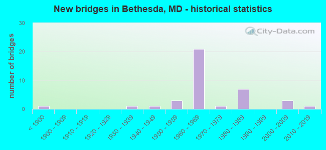
- New bridges - historical statistics
- 1Before 1900
- 11930-1939
- 11940-1949
- 31950-1959
- 211960-1969
- 11970-1979
- 71980-1989
- 32000-2009
- 12010-2019

- Reconstructed bridges - Historical Statistics
- 11950-1959
- 31960-1969
- 21970-1979
- 21980-1989
- 21990-1999
- 52000-2009


- Bridge Condition - Deck
- 30.0%Good
- 50.0%Satisfactory
- 20.0%Fair

- Bridge Condition - Superstructure
- 4.8%Very good
- 28.6%Good
- 42.9%Satisfactory
- 19.0%Fair
- 4.8%Poor

- Bridge Condition - Substructure
- 4.8%Excellent
- 23.8%Good
- 61.9%Satisfactory
- 9.5%Fair

- Bridge Condition - Channel
- 14.3%Very good
- 33.3%Good
- 38.1%Satisfactory
- 4.8%Fair
- 9.5%Poor

- Bridge Condition - Culverts
- 18.2%Good
- 45.5%Satisfactory
- 27.3%Fair
- 9.1%Poor
Find on map >> Show street view
Structure Number: 1MD0071, Location: 1 KM W OF RT. 185 (Lat: 39.001128, Lng: -77.085658), Route carried "on" structure: Other road , Year Built: 1980, Year Reconstructed: 2014, Status: Posted for load, Structure Length: 20.28m (66.54ft), Average Daily Traffic: 200 (year 2015), Truck Traffic: 5%, Average Future Daily Traffic: 250 (year 2040), Design Load: H 20, Features Intersected: PARKING GARAGE, Facility Carried by Structure: SOUTH PALMER ROAD
Minimum Vertical Clearance: 30+ m (98+ ft), Kilometerpoint: 0.000, Lanes on structure: 2, Owner: Navy/Marines, Approaching Roadway Width: 7.9m (25.9ft), Material/Design: Concrete, Design/Construction: Slab, Number Of Spans In Main Unit: 22, Length of Maximum Span: 9.4m (30.8ft), Curb or Sidewalk Widths: Left: 0.2m (0.7ft), Right: 0.2m (0.7ft), Curb-To-Curb Width: 7.9m (25.9ft), Out-to-Out Width: 9.1m (29.9ft)
Condition: Deck: Satisfactory, Superstructure: Satisfactory, Substructure: Satisfactory, Operating Rating: 25.1 metric tons, Method Used To Determine Operating Rating: Load and Resistance Factor (LRFR), Inventory Rating: 19.3 metric tons, Method Used To Determine Inventory Rating: Load and Resistance Factor (LRFR), Structural Evaluation: Somewhat better than minimum adequacy, Deck Geometry: Somewhat better than minimum adequacy, Approach Roadway Alignment: Better than present minimum criteria, Bridge Posting: Required (Relationship of Operating Rating to Maximum Legal Load: 20.0 - 29.9% below), Designated Inspection Frequency: Every 24 months, Inspection Date: June 2021, Bridge Improvement Cost: $13,000, Roadway Improvement Cost: $4,000, Total Project Cost: $16,000 ( Estimate for 2021), Deck Structure Type: Concrete Precast Panels, Wearing Surface/Protective System: Wearing Surface: Bituminous
Find on map >> Show street view
Structure Number: 1MD0135, Location: 0.1KM S OF MACARTHUR BLVD (Lat: 38.975083, Lng: -77.182483), Route carried "on" structure: Other road , Year Built: 1980, Status: Open, Structure Length: 0.78m (2.56ft), Average Daily Traffic: 500 (year 2019), Truck Traffic: 30%, Average Future Daily Traffic: 1,000 (year 2035), Design Load: HS 20, Features Intersected: ROCK RUN, Facility Carried by Structure: WITEX ROAD
Minimum Vertical Clearance: 30+ m (98+ ft), Kilometerpoint: 0.000, Lanes on structure: 2, Owner: Navy/Marines, Approaching Roadway Width: 7.2m (23.6ft), Material/Design: Steel, Design/Construction: Stringer/Multi-beam, Number Of Spans In Main Unit: 1, Length of Maximum Span: 7.0m (23.0ft), Curb-To-Curb Width: 7.2m (23.6ft), Out-to-Out Width: 7.8m (25.6ft)
Condition: Deck: Fair, Superstructure: Poor, Substructure: Fair, Channel: Poor, Operating Rating: 46.0 metric tons, Method Used To Determine Operating Rating: Load Factor (LF), Inventory Rating: 27.8 metric tons, Method Used To Determine Inventory Rating: Load Factor (LF), Structural Evaluation: Meets minimum limits, Deck Geometry: Meets minimum limits, Waterway Adequacy: Somewhat better than minimum adequacy, Approach Roadway Alignment: Equal to present minimum criteria, Length Of Structure Improvement: 0.83m (2.72ft), Designated Inspection Frequency: Every 24 months, Inspection Date: June 2021, Bridge Improvement Cost: $55,000, Roadway Improvement Cost: $26,000, Total Project Cost: $81,000 ( Estimate for 2021), Deck Structure Type: Concrete Cast-file-Place, Wearing Surface/Protective System: Wearing Surface: Monolithic Concrete
Find on map >> Show street view
Structure Number: 1MD018, Location: 50M EAST OF E PALMER RD (Lat: 38.999333, Lng: -77.091378), Route carried "on" structure: Other road , Year Built: 1950, Year Reconstructed: 2011, Status: Posted for load, Structure Length: 0.71m (2.33ft), Average Daily Traffic: 2,000 (year 2003), Truck Traffic: 10%, Average Future Daily Traffic: 2,500 (year 2040), Design Load: HS 20, Features Intersected: STONEY CREEK, Facility Carried by Structure: STOKES ROAD
Minimum Vertical Clearance: 30+ m (98+ ft), Kilometerpoint: 0.000, Lanes on structure: 2, Owner: Navy/Marines, Approaching Roadway Width: 7.9m (25.9ft), Skew: 1 degrees, Material/Design: Prestressed concrete, Design/Construction: Tee Beam, Number Of Spans In Main Unit: 1, Length of Maximum Span: 6.5m (21.3ft), Curb or Sidewalk Widths: Left: 1.8m (5.9ft), Right: 1.8m (5.9ft), Curb-To-Curb Width: 7.9m (25.9ft), Out-to-Out Width: 12.3m (40.4ft)
Condition: Deck: Good, Superstructure: Satisfactory, Substructure: Satisfactory, Channel: Good, Operating Rating: 27.0 metric tons, Method Used To Determine Operating Rating: Load and Resistance Factor (LRFR), Inventory Rating: 20.8 metric tons, Method Used To Determine Inventory Rating: Load and Resistance Factor (LRFR), Structural Evaluation: Somewhat better than minimum adequacy, Deck Geometry: Meets minimum limits, Waterway Adequacy: Equal to present desirable criteria, Approach Roadway Alignment: Equal to present minimum criteria, Bridge Posting: Required (Relationship of Operating Rating to Maximum Legal Load: 0.1 - 9.9% below), Length Of Structure Improvement: 0.65m (2.13ft), Designated Inspection Frequency: Every 24 months, Inspection Date: June 2021, Bridge Improvement Cost: $7,000, Roadway Improvement Cost: $3,000, Total Project Cost: $11,000 ( Estimate for 2021), Deck Structure Type: Concrete Cast-file-Place, Wearing Surface/Protective System: Wearing Surface: Integral Concrete
Find on map >> Show street view
Structure Number: 1MD0265, Location: 10M W STONE LAKE RD (Lat: 39.001611, Lng: -77.090167), Route carried "on" structure: Other road , Year Built: 1975, Status: Open, Structure Length: 0.79m (2.59ft), Average Daily Traffic: 500 (year 2015), Truck Traffic: 10%, Average Future Daily Traffic: 550 (year 2040), Design Load: HS 20, Features Intersected: STONEY CREEK, Facility Carried by Structure: E. RIXEY ROAD
Minimum Vertical Clearance: 30+ m (98+ ft), Kilometerpoint: 0.000, Lanes on structure: 2, Owner: Navy/Marines, Approaching Roadway Width: 9.0m (29.5ft), Skew: 1 degrees, Material/Design: Concrete, Design/Construction: Culvert, Number Of Spans In Main Unit: 2, Length of Maximum Span: 3.8m (12.5ft), Curb or Sidewalk Widths: Left: 0.0m, Right: 1.7m (5.6ft)
Condition: Channel: Satisfactory, Culverts: Satisfactory, Operating Rating: 36.3 metric tons, Method Used To Determine Operating Rating: Field evaluation and documented engineering judgment, Inventory Rating: 32.6 metric tons, Method Used To Determine Inventory Rating: Field evaluation and documented engineering judgment, Structural Evaluation: Equal to present minimum criteria, Waterway Adequacy: Equal to present desirable criteria, Approach Roadway Alignment: Equal to present minimum criteria, Length Of Structure Improvement: 0.79m (2.59ft), Designated Inspection Frequency: Every 24 months, Inspection Date: June 2021, Bridge Improvement Cost: $15,000, Roadway Improvement Cost: $2,000, Total Project Cost: $17,000 ( Estimate for 2021)
Find on map >> Show street view
Structure Number: 1MD260E, Location: 600M E OF WOOD RD (Lat: 39.000911, Lng: -77.090258), Route carried "on" structure: Other road , Year Built: 1981, Status: Open, Structure Length: 8.29m (27.20ft), Average Daily Traffic: 2,750 (year 2015), Truck Traffic: 5%, Average Future Daily Traffic: 3,300 (year 2040), Design Load: HS 20, Features Intersected: STONE LAKE RD/PARKING LT, Facility Carried by Structure: PALMER ROAD SOUTH
Minimum Vertical Clearance: 30+ m (98+ ft), Kilometerpoint: 0.000, Lanes on structure: 2, Lanes under structure: 2, Owner: Navy/Marines, Approaching Roadway Width: 7.9m (25.9ft), Material/Design: Concrete continuous, Design/Construction: Box Beam or Girders - Single/Spread, Number Of Spans In Main Unit: 3, Length of Maximum Span: 33.5m (109.9ft), Curb or Sidewalk Widths: Left: 1.5m (4.9ft), Right: 1.5m (4.9ft), Curb-To-Curb Width: 7.9m (25.9ft), Out-to-Out Width: 11.6m (38.1ft)
Condition: Deck: Satisfactory, Superstructure: Fair, Substructure: Satisfactory, Operating Rating: 48.9 metric tons, Method Used To Determine Operating Rating: Load Factor (LF), Inventory Rating: 29.3 metric tons, Method Used To Determine Inventory Rating: Load Factor (LF), Structural Evaluation: Somewhat better than minimum adequacy, Deck Geometry: High priority of corrective action, Underclear: High priority of corrective action, Approach Roadway Alignment: Equal to present minimum criteria, Length Of Structure Improvement: 8.29m (27.20ft), Designated Inspection Frequency: Every 24 months, Inspection Date: June 2021, Bridge Improvement Cost: $23,000, Roadway Improvement Cost: $7,000, Total Project Cost: $31,000 ( Estimate for 2021), Deck Structure Type: Concrete Cast-file-Place, Wearing Surface/Protective System: Wearing Surface: Bituminous
Find on map >> Show street view
Structure Number: 1MD260W, Location: 500M E OF WOOD RD (Lat: 39.000075, Lng: -77.091539), Route carried "on" structure: Other road , Year Built: 1981, Status: Open, Structure Length: 8.53m (27.99ft), Average Daily Traffic: 2,750 (year 2015), Truck Traffic: 5%, Average Future Daily Traffic: 3,300 (year 2040), Design Load: HS 20, Features Intersected: E PALMER RD,STONEY CREEK, Facility Carried by Structure: PALMER ROAD SOUTH
Minimum Vertical Clearance: 30+ m (98+ ft), Kilometerpoint: 0.000, Lanes on structure: 2, Lanes under structure: 2, Owner: Navy/Marines, Approaching Roadway Width: 7.9m (25.9ft), Material/Design: Concrete continuous, Design/Construction: Box Beam or Girders - Single/Spread, Number Of Spans In Main Unit: 3, Length of Maximum Span: 33.5m (109.9ft), Curb or Sidewalk Widths: Left: 1.5m (4.9ft), Right: 1.5m (4.9ft), Curb-To-Curb Width: 7.9m (25.9ft), Out-to-Out Width: 11.6m (38.1ft)
Condition: Deck: Satisfactory, Superstructure: Fair, Substructure: Satisfactory, Channel: Very good, Operating Rating: 62.2 metric tons, Method Used To Determine Operating Rating: Load Factor (LF), Inventory Rating: 37.3 metric tons, Method Used To Determine Inventory Rating: Load Factor (LF), Structural Evaluation: Somewhat better than minimum adequacy, Deck Geometry: High priority of corrective action, Underclear: High priority of corrective action, Waterway Adequacy: Superior to present desirable criteria, Approach Roadway Alignment: Equal to present minimum criteria, Length Of Structure Improvement: 8.29m (27.20ft), Designated Inspection Frequency: Every 24 months, Inspection Date: June 2021, Bridge Improvement Cost: $204,000, Roadway Improvement Cost: $15,000, Total Project Cost: $219,000 ( Estimate for 2021), Deck Structure Type: Concrete Cast-file-Place, Wearing Surface/Protective System: Wearing Surface: Bituminous
Find on map >> Show street view
Structure Number: 10000015002802, Location: 0.56 MILE EAST OF IS 495 (Lat: 38.988458, Lng: -77.148064), Route carried "on" structure: State highway 190, Year Built: 1962, Status: Open, Structure Length: 1.23m (4.04ft), Average Daily Traffic: 44,290 (year 2013), Truck Traffic: 8%, Average Future Daily Traffic: 50,746 (year 2026), Design Load: HS 20, Features Intersected: BOOZE CREEK
Minimum Vertical Clearance: 30+ m (98+ ft), Kilometerpoint: 19.453, Lanes on structure: 4, Base Highway Network: Yes, Owner: State Highway Agency, Approaching Roadway Width: 20.7m (67.9ft), Skew: 2 degrees, Material/Design: Concrete, Design/Construction: Culvert, Length of Maximum Span: 4.0m (13.1ft)
Condition: Channel: Satisfactory, Culverts: Satisfactory, Operating Rating: 32.7 metric tons, Method Used To Determine Operating Rating: Field evaluation and documented engineering judgment, Inventory Rating: 32.7 metric tons, Method Used To Determine Inventory Rating: Field evaluation and documented engineering judgment, Structural Evaluation: Equal to present minimum criteria, Waterway Adequacy: Equal to present minimum criteria, Approach Roadway Alignment: Equal to present desirable criteria, Designated Inspection Frequency: Every 24 months, Inspection Date: September 2020
Find on map >> Show street view
Structure Number: 10000015005001, Location: 0.08 MILE SOUTH OF MD 410 (Lat: 38.982594, Lng: -77.093281), Route carried "on" structure: State highway 355, Year Built: 1988, Status: Open, Structure Length: 2.01m (6.59ft), Average Daily Traffic: 37,840 (year 2009), Truck Traffic: 8%, Average Future Daily Traffic: 45,959 (year 2026), Design Load: HS 20, Features Intersected: CAPITAL CRESCENT TRAIL
Minimum Vertical Clearance: 30+ m (98+ ft), Kilometerpoint: 2.735, Lanes on structure: 6, Base Highway Network: Yes, Owner: State Highway Agency, Approaching Roadway Width: 25.0m (82.0ft), Skew: 20 degrees, Material/Design: Steel, Design/Construction: Stringer/Multi-beam, Number Of Spans In Main Unit: 1, Length of Maximum Span: 18.9m (62.0ft), Curb or Sidewalk Widths: Left: 1.7m (5.6ft), Right: 2.1m (6.9ft), Curb-To-Curb Width: 25.0m (82.0ft), Out-to-Out Width: 28.8m (94.5ft)
Condition: Deck: Satisfactory, Superstructure: Good, Substructure: Good, Inventory Rating: 85.7 metric tons, Method Used To Determine Inventory Rating: Load Factor (LF), Structural Evaluation: Better than present minimum criteria, Deck Geometry: Somewhat better than minimum adequacy, Approach Roadway Alignment: Equal to present desirable criteria, Length Of Structure Improvement: 2.01m (6.59ft), Designated Inspection Frequency: Every 24 months, Inspection Date: June 2020, Bridge Improvement Cost: $374,000, Roadway Improvement Cost: $37,000, Total Project Cost: $411,000, Deck Structure Type: Concrete Cast-file-Place, Wearing Surface/Protective System: Wearing Surface: Monolithic Concrete, Deck Protection: Epoxy Coated Reinforcing
Find on map >> Show street view
Structure Number: 10000015005701, Location: 0.69 MILE WEST OF WASH DC (Lat: 38.957619, Lng: -77.108275), Route carried "on" structure: State highway 396, Year Built: 1931, Year Reconstructed: 1973, Status: Open, Structure Length: 0.91m (2.99ft), Average Daily Traffic: 15,581 (year 2009), Truck Traffic: 8%, Average Future Daily Traffic: 19,487 (year 2026), Design Load: HS 20, Features Intersected: LITTLE FALLS BRANCH
Minimum Vertical Clearance: 30+ m (98+ ft), Kilometerpoint: 2.446, Lanes on structure: 6, Owner: State Highway Agency, Approaching Roadway Width: 28.3m (92.8ft), Skew: 20 degrees, Material/Design: Prestressed concrete, Design/Construction: Slab, Number Of Spans In Main Unit: 1, Length of Maximum Span: 8.5m (27.9ft), Curb or Sidewalk Widths: Left: 1.9m (6.2ft), Right: 1.9m (6.2ft), Curb-To-Curb Width: 28.3m (92.8ft), Out-to-Out Width: 32.4m (106.3ft)
Condition: Deck: Satisfactory, Superstructure: Satisfactory, Substructure: Satisfactory, Channel: Good, Operating Rating: 44.0 metric tons, Method Used To Determine Operating Rating: Load Factor (LF), Inventory Rating: 26.3 metric tons, Method Used To Determine Inventory Rating: Load Factor (LF), Structural Evaluation: Equal to present minimum criteria, Deck Geometry: Superior to present desirable criteria, Waterway Adequacy: Superior to present desirable criteria, Approach Roadway Alignment: Equal to present desirable criteria, Designated Inspection Frequency: Every 24 months, Inspection Date: August 2021, Deck Structure Type: Other, Wearing Surface/Protective System: Wearing Surface: Bituminous, Membrane: Other
Find on map >> Show street view
Structure Number: 10000015007102, Location: 0.44 MI W OF WASH DC (Lat: 38.960736, Lng: -77.097528), Route carried "on" structure: State highway 190, Year Built: 1962, Status: Open, Structure Length: 0.79m (2.59ft), Average Daily Traffic: 22,152 (year 2009), Truck Traffic: 8%, Average Future Daily Traffic: 27,455 (year 2026), Design Load: HS 20, Features Intersected: LITTLE FALLS
Minimum Vertical Clearance: 30+ m (98+ ft), Kilometerpoint: 24.833, Lanes on structure: 4, Base Highway Network: Yes, Owner: State Highway Agency, Approaching Roadway Width: 20.7m (67.9ft), Material/Design: Concrete, Design/Construction: Culvert, Length of Maximum Span: 2.4m (7.9ft)
Condition: Channel: Satisfactory, Culverts: Good, Operating Rating: 32.7 metric tons, Method Used To Determine Operating Rating: Field evaluation and documented engineering judgment, Inventory Rating: 32.7 metric tons, Method Used To Determine Inventory Rating: Field evaluation and documented engineering judgment, Structural Evaluation: Better than present minimum criteria, Waterway Adequacy: Equal to present minimum criteria, Approach Roadway Alignment: Equal to present desirable criteria, Designated Inspection Frequency: Every 24 months, Inspection Date: September 2020
Find on map >> Show street view
Structure Number: 10000015008402, Location: 0.48 MILE SOUTH OF IS 495 (Lat: 38.982225, Lng: -77.156892), Route carried "on" structure: Interstate 495X, Year Built: 1964, Status: Open, Structure Length: 1.43m (4.69ft), Average Daily Traffic: 19,820 (year 2009), Truck Traffic: 8%, Average Future Daily Traffic: 29,730 (year 2029), Design Load: H 20, Features Intersected: BOOZE CREEK
Minimum Vertical Clearance: 30+ m (98+ ft), Kilometerpoint: 1.641, Lanes on structure: 4, Base Highway Network: Yes, Owner: State Highway Agency, Approaching Roadway Width: 26.5m (86.9ft), Skew: 2 degrees, Material/Design: Concrete, Design/Construction: Culvert, Length of Maximum Span: 4.3m (14.1ft)
Condition: Channel: Satisfactory, Culverts: Satisfactory, Operating Rating: 54.4 metric tons, Method Used To Determine Operating Rating: Load Factor (LF), Inventory Rating: 32.7 metric tons, Method Used To Determine Inventory Rating: Load Factor (LF), Structural Evaluation: Equal to present minimum criteria, Waterway Adequacy: Equal to present minimum criteria, Approach Roadway Alignment: Equal to present desirable criteria, Designated Inspection Frequency: Every 24 months, Inspection Date: July 2020
Find on map >> Show street view
Structure Number: 10000015008501, Location: 0.22 MILE NORTH OF GV 6 (Lat: 38.973039, Lng: -77.148622), Route carried "on" structure: Interstate 495X, Year Built: 1964, Year Reconstructed: 1970, Status: Open, Structure Length: 8.81m (28.90ft), Average Daily Traffic: 19,820 (year 2009), Truck Traffic: 8%, Average Future Daily Traffic: 22,162 (year 2026), Design Load: H 20, Features Intersected: CABIN JOHN CREEK
Minimum Vertical Clearance: 12.19m (39.99ft), Kilometerpoint: 0.354, Lanes on structure: 4, Base Highway Network: Yes, Owner: State Highway Agency, Approaching Roadway Width: 25.6m (84.0ft), Skew: 25 degrees, Material/Design: Steel, Design/Construction: Stringer/Multi-beam, Number Of Spans In Main Unit: 5, Length of Maximum Span: 18.9m (62.0ft), Curb-To-Curb Width: 21.3m (69.9ft), Out-to-Out Width: 22.9m (75.1ft)
Condition: Deck: Fair, Superstructure: Satisfactory, Substructure: Satisfactory, Channel: Very good, Operating Rating: 55.3 metric tons, Method Used To Determine Operating Rating: Load Factor (LF), Inventory Rating: 33.1 metric tons, Method Used To Determine Inventory Rating: Load Factor (LF), Structural Evaluation: Equal to present minimum criteria, Deck Geometry: Better than present minimum criteria, Waterway Adequacy: Equal to present desirable criteria, Approach Roadway Alignment: Equal to present desirable criteria, Length Of Structure Improvement: 8.81m (28.90ft), Designated Inspection Frequency: Every 24 months, Inspection Date: April 2021, Bridge Improvement Cost: $1,304,000, Roadway Improvement Cost: $130,000, Total Project Cost: $1,434,000, Deck Structure Type: Concrete Cast-file-Place, Wearing Surface/Protective System: Wearing Surface: Bituminous
Find on map >> Show street view
Structure Number: 10000015010801, Location: 0.49 MILE WEST OF MD 190 (Lat: 38.984356, Lng: -77.159200), Route carried "on" structure: Interstate 495, Year Built: 1962, Year Reconstructed: 1991, Status: Open, Structure Length: 10.79m (35.40ft), Average Daily Traffic: 214,005 (year 2009), Truck Traffic: 8%, Average Future Daily Traffic: 263,471 (year 2038), Design Load: HS 20+Mod, Features Intersected: IS 495X & C J CR
Minimum Vertical Clearance: 30+ m (98+ ft), Kilometerpoint: 3.025, Lanes on structure: 8, Lanes under structure: 2, Base Highway Network: Yes, Owner: State Highway Agency, Approaching Roadway Width: 46.3m (151.9ft), Skew: 24 degrees, Material/Design: Steel, Design/Construction: Stringer/Multi-beam, Number Of Spans In Main Unit: 5, Length of Maximum Span: 25.3m (83.0ft), Curb-To-Curb Width: 46.4m (152.2ft), Out-to-Out Width: 47.6m (156.2ft)
Condition: Deck: Satisfactory, Superstructure: Satisfactory, Substructure: Satisfactory, Channel: Very good, Inventory Rating: 63.9 metric tons, Method Used To Determine Inventory Rating: Load Factor (LF), Structural Evaluation: Equal to present minimum criteria, Deck Geometry: Superior to present desirable criteria, Underclear: High priority of corrective action, Waterway Adequacy: Equal to present desirable criteria, Approach Roadway Alignment: Equal to present desirable criteria, Length Of Structure Improvement: 10.79m (35.40ft), Designated Inspection Frequency: Every 24 months, Inspection Date: August 2020, Bridge Improvement Cost: $3,316,000, Roadway Improvement Cost: $332,000, Total Project Cost: $3,648,000, Deck Structure Type: Concrete Cast-file-Place, Wearing Surface/Protective System: Wearing Surface: Bituminous, Deck Protection: Epoxy Coated Reinforcing
Find on map >> Show street view
Structure Number: 10000015010901, Location: 0.48 MI W OF MD 190 (Lat: 38.985356, Lng: -77.157544), Route carried "on" structure: Ramp Interstate 495, Year Built: 1964, Year Reconstructed: 2006, Status: Open, Structure Length: 6.25m (20.51ft), Average Daily Traffic: 8,755 (year 2006), Truck Traffic: 8%, Average Future Daily Traffic: 9,455 (year 2026), Design Load: HS 25 or greater, Features Intersected: IS 495X NBR
Minimum Vertical Clearance: 30+ m (98+ ft), Kilometerpoint: 0.145, Lanes on structure: 1, Lanes under structure: 2, Base Highway Network: Yes, Owner: State Highway Agency, Approaching Roadway Width: 6.1m (20.0ft), Skew: 6 degrees, Material/Design: Steel, Design/Construction: Stringer/Multi-beam, Number Of Spans In Main Unit: 3, Length of Maximum Span: 25.6m (84.0ft), Curb-To-Curb Width: 7.4m (24.3ft), Out-to-Out Width: 8.6m (28.2ft)
Condition: Deck: Good, Superstructure: Good, Substructure: Good, Operating Rating: 80.7 metric tons, Method Used To Determine Operating Rating: Load Factor (LF), Inventory Rating: 48.1 metric tons, Method Used To Determine Inventory Rating: Load Factor (LF), Structural Evaluation: Better than present minimum criteria, Deck Geometry: Better than present minimum criteria, Underclear: High priority of replacement, Approach Roadway Alignment: Equal to present desirable criteria, Length Of Structure Improvement: 6.10m (20.01ft), Designated Inspection Frequency: Every 24 months, Inspection Date: March 2021, Bridge Improvement Cost: $612,000, Roadway Improvement Cost: $61,000, Total Project Cost: $673,000, Deck Structure Type: Concrete Cast-file-Place, Wearing Surface/Protective System: Wearing Surface: Bituminous
Find on map >> Show street view
Structure Number: 10000015011301, Location: @ IS 495 (Lat: 39.012969, Lng: -77.144739), Route carried "on" structure: County highway 167, Year Built: 1962, Year Reconstructed: 1971, Status: Open, Structure Length: 7.25m (23.79ft), Average Daily Traffic: 8,600 (year 1994), Truck Traffic: 5%, Average Future Daily Traffic: 10,148 (year 2012), Design Load: H 20, Features Intersected: IS 495, Facility Carried by Structure: GREENTREE RD
Minimum Vertical Clearance: 30+ m (98+ ft), Kilometerpoint: 3.781, Lanes on structure: 2, Lanes under structure: 6, Owner: State Highway Agency, Approaching Roadway Width: 9.1m (29.9ft), Skew: 2 degrees, Material/Design: Steel, Design/Construction: Stringer/Multi-beam, Number Of Spans In Main Unit: 4, Length of Maximum Span: 22.6m (74.1ft), Curb or Sidewalk Widths: Left: 1.3m (4.3ft), Right: 1.3m (4.3ft), Curb-To-Curb Width: 9.1m (29.9ft), Out-to-Out Width: 12.3m (40.4ft)
Condition: Deck: Fair, Superstructure: Satisfactory, Substructure: Satisfactory, Operating Rating: 68.0 metric tons, Method Used To Determine Operating Rating: Load Factor (LF), Inventory Rating: 40.8 metric tons, Method Used To Determine Inventory Rating: Load Factor (LF), Structural Evaluation: Equal to present minimum criteria, Deck Geometry: Meets minimum limits, Underclear: Meets minimum limits, Approach Roadway Alignment: Equal to present desirable criteria, Length Of Structure Improvement: 7.25m (23.79ft), Designated Inspection Frequency: Every 24 months, Inspection Date: April 2020, Bridge Improvement Cost: $574,000, Roadway Improvement Cost: $57,000, Total Project Cost: $631,000, Deck Structure Type: Concrete Cast-file-Place, Wearing Surface/Protective System: Wearing Surface: Bituminous
Find on map >> Show street view
Structure Number: 10000015011401, Location: @ IS 495 (Lat: 39.012872, Lng: -77.133256), Route carried "on" structure: County highway 837, Year Built: 1962, Year Reconstructed: 1971, Status: Open, Structure Length: 6.31m (20.70ft), Average Daily Traffic: 16,350 (year 1994), Truck Traffic: 5%, Average Future Daily Traffic: 12,397 (year 2012), Design Load: H 20, Features Intersected: IS 495, Facility Carried by Structure: FERNWOOD RD
Minimum Vertical Clearance: 30+ m (98+ ft), Kilometerpoint: 0.917, Lanes on structure: 2, Lanes under structure: 6, Owner: State Highway Agency, Approaching Roadway Width: 10.4m (34.1ft), Material/Design: Steel, Design/Construction: Stringer/Multi-beam, Number Of Spans In Main Unit: 4, Length of Maximum Span: 20.1m (65.9ft), Curb or Sidewalk Widths: Left: 1.3m (4.3ft), Right: 1.3m (4.3ft), Curb-To-Curb Width: 9.1m (29.9ft), Out-to-Out Width: 12.3m (40.4ft)
Condition: Deck: Fair, Superstructure: Satisfactory, Substructure: Satisfactory, Operating Rating: 67.6 metric tons, Method Used To Determine Operating Rating: Load Factor (LF), Inventory Rating: 40.4 metric tons, Method Used To Determine Inventory Rating: Load Factor (LF), Structural Evaluation: Equal to present minimum criteria, Deck Geometry: Meets minimum limits, Underclear: Meets minimum limits, Approach Roadway Alignment: Equal to present desirable criteria, Length Of Structure Improvement: 6.31m (20.70ft), Designated Inspection Frequency: Every 24 months, Inspection Date: May 2020, Bridge Improvement Cost: $499,000, Roadway Improvement Cost: $50,000, Total Project Cost: $549,000, Deck Structure Type: Concrete Cast-file-Place, Wearing Surface/Protective System: Wearing Surface: Bituminous
Find on map >> Show street view
Structure Number: 10000015011501, Location: 1.1 MILES WEST OF MD 355 (Lat: 39.015708, Lng: -77.119378), Route carried "on" structure: Interstate 495, Year Built: 2000, Status: Open, Structure Length: 4.11m (13.48ft), Average Daily Traffic: 113,030 (year 2006), Truck Traffic: 12%, Average Future Daily Traffic: 112,072 (year 2026), Design Load: HS 25 or greater, Features Intersected: MD 187 (OLD GEORGETOWN R
Minimum Vertical Clearance: 30+ m (98+ ft), Kilometerpoint: 9.026, Lanes on structure: 6, Lanes under structure: 7, Base Highway Network: Yes, Owner: State Highway Agency, Approaching Roadway Width: 41.1m (134.8ft), Skew: 32 degrees, Material/Design: Steel, Design/Construction: Stringer/Multi-beam, Number Of Spans In Main Unit: 1, Length of Maximum Span: 41.1m (134.8ft), Curb-To-Curb Width: 34.1m (111.9ft), Out-to-Out Width: 36.2m (118.8ft)
Condition: Deck: Good, Superstructure: Good, Substructure: Good, Operating Rating: 79.4 metric tons, Method Used To Determine Operating Rating: Load Factor (LF), Inventory Rating: 47.6 metric tons, Method Used To Determine Inventory Rating: Load Factor (LF), Structural Evaluation: Better than present minimum criteria, Deck Geometry: Superior to present desirable criteria, Underclear: Better than present minimum criteria, Approach Roadway Alignment: Equal to present desirable criteria, Designated Inspection Frequency: Every 24 months, Inspection Date: April 2020, Deck Structure Type: Concrete Cast-file-Place, Wearing Surface/Protective System: Wearing Surface: Integral Concrete, Deck Protection: Epoxy Coated Reinforcing
Find on map >> Show street view
Structure Number: 10000015012001, Location: 1.31 MILES S OF MD 547 (Lat: 39.017386, Lng: -77.102061), Route carried "on" structure: State highway 355, Year Built: 1960, Status: Open, Structure Length: 8.96m (29.40ft), Average Daily Traffic: 55,020 (year 2009), Truck Traffic: 8%, Average Future Daily Traffic: 39,969 (year 2026), Design Load: HS 20, Features Intersected: IS 495 IL
Minimum Vertical Clearance: 30+ m (98+ ft), Kilometerpoint: 6.372, Lanes on structure: 3, Lanes under structure: 4, Base Highway Network: Yes, Owner: State Highway Agency, Approaching Roadway Width: 14.6m (47.9ft), Skew: 6 degrees, Material/Design: Steel, Design/Construction: Stringer/Multi-beam, Number Of Spans In Main Unit: 3, Length of Maximum Span: 42.1m (138.1ft), Curb-To-Curb Width: 14.6m (47.9ft), Out-to-Out Width: 16.4m (53.8ft)
Condition: Deck: Good, Superstructure: Satisfactory, Substructure: Fair, Operating Rating: 33.1 metric tons, Method Used To Determine Operating Rating: Load Factor (LF), Inventory Rating: 20.0 metric tons, Method Used To Determine Inventory Rating: Load Factor (LF), Structural Evaluation: Somewhat better than minimum adequacy, Deck Geometry: Somewhat better than minimum adequacy, Underclear: High priority of corrective action, Approach Roadway Alignment: Equal to present desirable criteria, Length Of Structure Improvement: 8.96m (29.40ft), Designated Inspection Frequency: Every 24 months, Inspection Date: October 2021, Bridge Improvement Cost: $947,000, Roadway Improvement Cost: $95,000, Total Project Cost: $1,042,000, Deck Structure Type: Concrete Cast-file-Place, Wearing Surface/Protective System: Wearing Surface: Bituminous
Find on map >> Show street view
Structure Number: 10000015012101, Location: 1.31 MILES S OF MD 547 (Lat: 39.016383, Lng: -77.100303), Route carried "on" structure: State highway 355, Year Built: 1960, Year Reconstructed: 1983, Status: Open, Structure Length: 7.07m (23.20ft), Average Daily Traffic: 55,020 (year 2009), Truck Traffic: 8%, Average Future Daily Traffic: 39,969 (year 2026), Design Load: HS 20, Features Intersected: IS 495 IL & Ramp 5
Minimum Vertical Clearance: 30+ m (98+ ft), Kilometerpoint: 6.372, Lanes on structure: 3, Lanes under structure: 5, Base Highway Network: Yes, Owner: State Highway Agency, Approaching Roadway Width: 11.0m (36.1ft), Skew: 4 degrees, Material/Design: Steel, Design/Construction: Stringer/Multi-beam, Number Of Spans In Main Unit: 3, Length of Maximum Span: 37.8m (124.0ft), Curb or Sidewalk Widths: Left: 0.0m, Right: 1.6m (5.2ft), Curb-To-Curb Width: 11.0m (36.1ft), Out-to-Out Width: 13.6m (44.6ft)
Condition: Deck: Good, Superstructure: Satisfactory, Substructure: Satisfactory, Operating Rating: 63.0 metric tons, Method Used To Determine Operating Rating: Load Factor (LF), Inventory Rating: 37.6 metric tons, Method Used To Determine Inventory Rating: Load Factor (LF), Structural Evaluation: Equal to present minimum criteria, Deck Geometry: High priority of replacement, Underclear: High priority of replacement, Approach Roadway Alignment: Equal to present desirable criteria, Length Of Structure Improvement: 7.07m (23.20ft), Designated Inspection Frequency: Every 24 months, Inspection Date: October 2021, Bridge Improvement Cost: $1,244,000, Roadway Improvement Cost: $124,000, Total Project Cost: $1,368,000, Deck Structure Type: Concrete Cast-file-Place, Wearing Surface/Protective System: Wearing Surface: Monolithic Concrete
Find on map >> Show street view
Structure Number: 10000015012201, Location: 0.65 MILE EAST OF MD 355 (Lat: 39.011225, Lng: -77.091436), Route carried "on" structure: Interstate 495, Year Built: 1964, Year Reconstructed: 1990, Status: Open, Structure Length: 3.26m (10.70ft), Average Daily Traffic: 238,050 (year 2009), Truck Traffic: 8%, Average Future Daily Traffic: 357,075 (year 2029), Design Load: HS 20+Mod, Features Intersected: CEDAR LANE
Minimum Vertical Clearance: 30+ m (98+ ft), Kilometerpoint: 11.842, Lanes on structure: 9, Lanes under structure: 4, Base Highway Network: Yes, Owner: State Highway Agency, Approaching Roadway Width: 49.7m (163.1ft), Skew: 21 degrees, Material/Design: Steel, Design/Construction: Stringer/Multi-beam, Number Of Spans In Main Unit: 3, Length of Maximum Span: 16.5m (54.1ft), Curb-To-Curb Width: 48.2m (158.1ft), Out-to-Out Width: 50.0m (164.0ft)
Condition: Deck: Satisfactory, Superstructure: Fair, Substructure: Satisfactory, Operating Rating: 63.9 metric tons, Method Used To Determine Operating Rating: Load Factor (LF), Inventory Rating: 38.1 metric tons, Method Used To Determine Inventory Rating: Load Factor (LF), Structural Evaluation: Somewhat better than minimum adequacy, Deck Geometry: Superior to present desirable criteria, Underclear: Meets minimum limits, Approach Roadway Alignment: Equal to present desirable criteria, Length Of Structure Improvement: 3.26m (10.70ft), Designated Inspection Frequency: Every 24 months, Inspection Date: May 2021, Bridge Improvement Cost: $351,000, Roadway Improvement Cost: $35,000, Total Project Cost: $386,000, Deck Structure Type: Concrete Cast-file-Place, Wearing Surface/Protective System: Wearing Surface: Bituminous
Find on map >> Show street view
Structure Number: 10000015014103, Location: 0.6 MILE EAST OF MD 355 (Lat: 39.011464, Lng: -77.092094), Route carried "on" structure: Interstate 495, Year Built: 1958, Year Reconstructed: 1964, Status: Open, Structure Length: 0.67m (2.20ft), Average Daily Traffic: 238,050 (year 2009), Truck Traffic: 8%, Average Future Daily Traffic: 357,075 (year 2029), Design Load: HS 20, Features Intersected: BR OF ROCK CREEK
Minimum Vertical Clearance: 30+ m (98+ ft), Kilometerpoint: 11.636, Lanes on structure: 4, Base Highway Network: Yes, Owner: State Highway Agency, Approaching Roadway Width: 46.0m (150.9ft), Skew: 2 degrees, Material/Design: Steel, Design/Construction: Culvert, Length of Maximum Span: 2.7m (8.9ft)
Condition: Channel: Satisfactory, Culverts: Satisfactory, Structural Evaluation: Equal to present minimum criteria, Waterway Adequacy: Better than present minimum criteria, Approach Roadway Alignment: Equal to present desirable criteria, Designated Inspection Frequency: Every 24 months, Inspection Date: August 2020
Find on map >> Show street view
Structure Number: 200000M-007501, Location: 0.1 MI S FORSYTHE AVENUE (Lat: 39.010989, Lng: -77.063061), Route carried "on" structure: County highway 4460, Year Built: 1969, Year Reconstructed: 2000, Status: Open, Structure Length: 6.13m (20.11ft), Average Daily Traffic: 14,669 (year 2020), Truck Traffic: 10%, Average Future Daily Traffic: 16,293 (year 2040), Design Load: HS 20, Features Intersected: ROCK CREEK, Facility Carried by Structure: JONES MILL ROAD
Minimum Vertical Clearance: 30+ m (98+ ft), Kilometerpoint: 0.097, Lanes on structure: 2, Owner: County Highway Agency, Approaching Roadway Width: 7.9m (25.9ft), Skew: 3 degrees, Material/Design: Steel, Design/Construction: Stringer/Multi-beam, Number Of Spans In Main Unit: 4, Length of Maximum Span: 15.5m (50.9ft), Curb or Sidewalk Widths: Left: 2.9m (9.5ft), Right: 0.0m, Curb-To-Curb Width: 7.3m (24.0ft), Out-to-Out Width: 11.1m (36.4ft)
Condition: Deck: Good, Superstructure: Good, Substructure: Satisfactory, Channel: Good, Operating Rating: 63.5 metric tons, Method Used To Determine Operating Rating: Load Factor (LF), Inventory Rating: 38.1 metric tons, Method Used To Determine Inventory Rating: Load Factor (LF), Structural Evaluation: Equal to present minimum criteria, Deck Geometry: High priority of replacement, Waterway Adequacy: Equal to present desirable criteria, Approach Roadway Alignment: Equal to present desirable criteria, Length Of Structure Improvement: 6.13m (20.11ft), Designated Inspection Frequency: Every 24 months, Inspection Date: June 2020, Bridge Improvement Cost: $10,000, Roadway Improvement Cost: $1,000, Total Project Cost: $11,000, Deck Structure Type: Concrete Cast-file-Place, Wearing Surface/Protective System: Wearing Surface: Integral Concrete
Find on map >> Show street view
Structure Number: 200000M-014302, Location: .1 MI S OF DEMOCRACY BLVD (Lat: 39.022733, Lng: -77.162431), Route carried "on" structure: County highway 148, Year Built: 1960, Year Reconstructed: 1992, Status: Open, Structure Length: 1.37m (4.49ft), Average Daily Traffic: 30,260 (year 2021), Truck Traffic: 5%, Average Future Daily Traffic: 36,695 (year 2041), Design Load: HS 20, Features Intersected: CABIN JOHN CREEK, Facility Carried by Structure: SEVEN LOCKS ROAD
Minimum Vertical Clearance: 30+ m (98+ ft), Kilometerpoint: 3.218, Lanes on structure: 5, Owner: County Highway Agency, Approaching Roadway Width: 21.6m (70.9ft), Skew: 2 degrees, Material/Design: Concrete, Design/Construction: Culvert, Number Of Spans In Main Unit: 3, Length of Maximum Span: 4.3m (14.1ft), Curb or Sidewalk Widths: Left: 1.5m (4.9ft), Right: 0.0m
Condition: Channel: Poor, Culverts: Fair, Inventory Rating: 71.2 metric tons, Method Used To Determine Inventory Rating: Load Factor (LF), Structural Evaluation: Somewhat better than minimum adequacy, Waterway Adequacy: Somewhat better than minimum adequacy, Approach Roadway Alignment: Equal to present desirable criteria, Designated Inspection Frequency: Every 24 months, Inspection Date: Febuary 2021
Find on map >> Show street view
Structure Number: 200000M-014402, Location: .1 MI E OF SEVEN LOCKS RD (Lat: 39.023261, Lng: -77.161436), Route carried "on" structure: County highway 166, Year Built: 1967, Status: Open, Structure Length: 1.37m (4.49ft), Average Daily Traffic: 31,775 (year 2019), Truck Traffic: 5%, Average Future Daily Traffic: 37,487 (year 2039), Design Load: HS 20, Features Intersected: CABIN JOHN CREEK, Facility Carried by Structure: DEMOCRACY BOULEVAR
Minimum Vertical Clearance: 30+ m (98+ ft), Kilometerpoint: 3.218, Lanes on structure: 7, Owner: County Highway Agency, Approaching Roadway Width: 26.8m (87.9ft), Skew: 22 degrees, Material/Design: Concrete, Design/Construction: Culvert, Length of Maximum Span: 4.0m (13.1ft), Curb or Sidewalk Widths: Left: 0.0m, Right: 1.2m (3.9ft)
Condition: Channel: Fair, Culverts: Satisfactory, Structural Evaluation: Equal to present minimum criteria, Waterway Adequacy: Equal to present minimum criteria, Approach Roadway Alignment: Equal to present desirable criteria, Designated Inspection Frequency: Every 24 months, Inspection Date: Febuary 2021
Find on map >> Show street view
Structure Number: 200000M-018002, Location: 0.5 MI E OF JCT SR 191 (Lat: 39.002200, Lng: -77.129081), Route carried "on" structure: County highway 167, Year Built: 1949, Status: Open, Structure Length: 0.76m (2.49ft), Average Daily Traffic: 10,539 (year 2018), Truck Traffic: 5%, Average Future Daily Traffic: 13,138 (year 2036), Design Load: H 20, Features Intersected: BULLS RUN, Facility Carried by Structure: GREENTREE ROAD
Minimum Vertical Clearance: 30+ m (98+ ft), Kilometerpoint: 1.754, Lanes on structure: 2, Owner: County Highway Agency, Approaching Roadway Width: 10.7m (35.1ft), Material/Design: Concrete, Design/Construction: Culvert, Length of Maximum Span: 3.7m (12.1ft), Curb or Sidewalk Widths: Left: 2.0m (6.6ft), Right: 0.0m, Curb-To-Curb Width: 9.2m (30.2ft), Out-to-Out Width: 11.6m (38.1ft)
Condition: Channel: Satisfactory, Culverts: Poor, Operating Rating: 61.7 metric tons, Method Used To Determine Operating Rating: Load Factor (LF), Inventory Rating: 37.2 metric tons, Method Used To Determine Inventory Rating: Load Factor (LF), Structural Evaluation: Meets minimum limits, Deck Geometry: High priority of corrective action, Waterway Adequacy: Better than present minimum criteria, Approach Roadway Alignment: Equal to present minimum criteria, Length Of Structure Improvement: 2.13m (6.99ft), Designated Inspection Frequency: Every 24 months, Inspection Date: March 2021, Bridge Improvement Cost: $530,000,000, Roadway Improvement Cost: $100,000,000, Total Project Cost: $630,000,000 ( Estimate for 2018)
Find on map >> Show street view
Structure Number: 200000M-035502, Location: 70 FT SOUTH OF MD 410 (Lat: 38.984497, Lng: -77.094483), Route carried "on" structure: State highway 355, Year Built: 1984, Status: Open, Structure Length: 1.07m (3.51ft), Average Daily Traffic: 40,769 (year 2021), Truck Traffic: 2%, Average Future Daily Traffic: 37,775 (year 2041), Design Load: HS 20, Features Intersected: BETHESDA METRO PED. TUNN, Facility Carried by Structure: WISCONSIN AVENUE
Minimum Vertical Clearance: 30+ m (98+ ft), Kilometerpoint: 2.703, Lanes on structure: 7, Owner: County Highway Agency, Approaching Roadway Width: 25.9m (85.0ft), Skew: 22 degrees, Material/Design: Concrete, Design/Construction: Culvert, Length of Maximum Span: 10.7m (35.1ft), Curb or Sidewalk Widths: Left: 0.3m (1.0ft), Right: 0.5m (1.6ft)
Condition: Culverts: Good, Structural Evaluation: Better than present minimum criteria, Approach Roadway Alignment: Equal to present desirable criteria, Designated Inspection Frequency: Every 24 months, Inspection Date: January 2021
Find on map >> Show street view
Structure Number: 200000M-043203, Location: 0.5 MI N. OF MD 191 (Lat: 39.018944, Lng: -77.161056), Route carried "on" structure: County highway 148, Year Built: 1965, Status: Open, Structure Length: 0.67m (2.20ft), Average Daily Traffic: 19,905 (year 2017), Truck Traffic: 5%, Average Future Daily Traffic: 24,676 (year 2037), Features Intersected: CABIN JOHN CREEK TRIBUTA, Facility Carried by Structure: SEVEN LOCKS ROAD
Minimum Vertical Clearance: 30+ m (98+ ft), Kilometerpoint: 0.000, Lanes on structure: 2, Owner: County Highway Agency, Approaching Roadway Width: 13.1m (43.0ft), Skew: 5 degrees, Material/Design: Steel, Design/Construction: Culvert, Length of Maximum Span: 1.8m (5.9ft)
Condition: Channel: Satisfactory, Culverts: Fair, Structural Evaluation: Somewhat better than minimum adequacy, Waterway Adequacy: Equal to present desirable criteria, Approach Roadway Alignment: Equal to present desirable criteria, Designated Inspection Frequency: Every 24 months, Inspection Date: Febuary 2020
Find on map >> Show street view
Structure Number: 200000M-PK01011, Location: 0.1 MI N DORSET AVE (Lat: 38.970253, Lng: -77.100464), Route carried "on" structure: Federal lands road 33, Year Built: 1958, Year Reconstructed: 2005, Status: Open, Structure Length: 1.49m (4.89ft), Average Daily Traffic: 16,840 (year 2017), Truck Traffic: 1%, Average Future Daily Traffic: 38,000 (year 2037), Design Load: HS 25 or greater, Features Intersected: WILLET BRANCH, Facility Carried by Structure: LITTLE FALLS PARKW
Minimum Vertical Clearance: 30+ m (98+ ft), Kilometerpoint: 1.754, Lanes on structure: 2, Owner: Local Park, Forest, or Reservation Agency, Maintenance Responsibility: County Highway Agency, Approaching Roadway Width: 10.4m (34.1ft), Skew: 3 degrees, Material/Design: Prestressed concrete, Design/Construction: Slab, Number Of Spans In Main Unit: 1, Length of Maximum Span: 14.0m (45.9ft), Curb-To-Curb Width: 9.4m (30.8ft), Out-to-Out Width: 10.4m (34.1ft)
Condition: Deck: Satisfactory, Superstructure: Good, Substructure: Good, Channel: Satisfactory, Operating Rating: 63.9 metric tons, Method Used To Determine Operating Rating: Load Factor (LF), Inventory Rating: 38.1 metric tons, Method Used To Determine Inventory Rating: Load Factor (LF), Structural Evaluation: Better than present minimum criteria, Deck Geometry: Meets minimum limits, Waterway Adequacy: Better than present minimum criteria, Approach Roadway Alignment: Equal to present desirable criteria, Designated Inspection Frequency: Every 24 months, Inspection Date: Febuary 2021, Deck Structure Type: Concrete Cast-file-Place, Wearing Surface/Protective System: Wearing Surface: Monolithic Concrete, Deck Protection: Epoxy Coated Reinforcing
Find on map >> Show street view
Structure Number: 200000M-PK01012, Location: 0.1 MI N DORSET AVE (Lat: 38.970172, Lng: -77.100658), Route carried "on" structure: Federal lands road 33, Year Built: 1963, Status: Open, Structure Length: 1.40m (4.59ft), Average Daily Traffic: 16,840 (year 2017), Truck Traffic: 1%, Average Future Daily Traffic: 38,000 (year 2037), Design Load: H 20, Features Intersected: WILLET BRANCH, Facility Carried by Structure: LITTLE FALLS PARKW
Minimum Vertical Clearance: 30+ m (98+ ft), Kilometerpoint: 1.754, Lanes on structure: 2, Owner: Local Park, Forest, or Reservation Agency, Maintenance Responsibility: County Highway Agency, Approaching Roadway Width: 8.5m (27.9ft), Skew: 3 degrees, Material/Design: Prestressed concrete, Design/Construction: Box Beam or Girders - Multiple, Number Of Spans In Main Unit: 1, Length of Maximum Span: 13.1m (43.0ft), Curb or Sidewalk Widths: Left: 1.7m (5.6ft), Right: 1.7m (5.6ft), Curb-To-Curb Width: 7.3m (24.0ft), Out-to-Out Width: 10.7m (35.1ft)
Condition: Deck: Satisfactory, Superstructure: Fair, Substructure: Satisfactory, Channel: Good, Operating Rating: 78.9 metric tons, Method Used To Determine Operating Rating: Load Factor (LF), Inventory Rating: 46.7 metric tons, Method Used To Determine Inventory Rating: Load Factor (LF), Structural Evaluation: Somewhat better than minimum adequacy, Deck Geometry: High priority of replacement, Waterway Adequacy: Better than present minimum criteria, Approach Roadway Alignment: Equal to present desirable criteria, Length Of Structure Improvement: 1.40m (4.59ft), Designated Inspection Frequency: Every 12 months, Inspection Date: Febuary 2021, Bridge Improvement Cost: $50,000, Roadway Improvement Cost: $5,000, Total Project Cost: $55,000, Wearing Surface/Protective System: Wearing Surface: Bituminous
Find on map >> Show street view
Structure Number: 200000M-PK1301, Location: 0.3 MI N OF CEDAR LANE (Lat: 39.009111, Lng: -77.094625), Route carried "on" structure: County highway 13, Year Built: 2016, Status: Open, Structure Length: 0.63m (2.07ft), Average Daily Traffic: 718 (year 2019), Truck Traffic: 3%, Average Future Daily Traffic: 769 (year 2039), Design Load: HS 20, Features Intersected: ROCK CREEK TRIBUTARY, Facility Carried by Structure: ELMHIRST PARKWAY
Minimum Vertical Clearance: 30+ m (98+ ft), Kilometerpoint: 0.113, Lanes on structure: 2, Owner: County Highway Agency, Approaching Roadway Width: 67.1m (220.1ft), Skew: 3 degrees, Material/Design: Concrete, Design/Construction: Arch - Deck, Number Of Spans In Main Unit: 1, Length of Maximum Span: 4.9m (16.1ft), Curb-To-Curb Width: 11.9m (39.0ft), Out-to-Out Width: 11.9m (39.0ft)
Condition: Superstructure: Very good, Substructure: Excellent, Channel: Good, Operating Rating: 51.8 metric tons, Method Used To Determine Operating Rating: Load and Resistance Factor Rating (LRFR) rating reported by rating factor(RF) method using HL-93 loadings, Inventory Rating: 42.1 metric tons, Method Used To Determine Inventory Rating: Load and Resistance Factor Rating (LRFR) rating reported by rating factor(RF) method using HL-93 loadings, Structural Evaluation: Equal to present desirable criteria, Deck Geometry: Better than present minimum criteria, Waterway Adequacy: Somewhat better than minimum adequacy, Approach Roadway Alignment: Equal to present desirable criteria, Designated Inspection Frequency: Every 24 months, Inspection Date: October 2020
Find on map >> Show street view
Structure Number: 200000M-PK2703, Location: 0.3 MI SW OF RIVER RD (Lat: 38.959611, Lng: -77.103250), Route carried "on" structure: County highway 33, Year Built: 1980, Status: Open, Structure Length: 0.82m (2.69ft), Average Daily Traffic: 16,691 (year 2020), Truck Traffic: 1%, Average Future Daily Traffic: 20,366 (year 2040), Features Intersected: LITTLE FALLS BRANCH TRIB, Facility Carried by Structure: LITTLE FALLS PARKW
Minimum Vertical Clearance: 30+ m (98+ ft), Kilometerpoint: 0.000, Lanes on structure: 2, Owner: County Highway Agency, Approaching Roadway Width: 10.1m (33.1ft), Skew: 4 degrees, Material/Design: Steel, Design/Construction: Culvert, Length of Maximum Span: 0.0m
Condition: Channel: Good, Culverts: Fair, Operating Rating: 32.7 metric tons, Method Used To Determine Operating Rating: Field evaluation and documented engineering judgment, Inventory Rating: 32.7 metric tons, Method Used To Determine Inventory Rating: Field evaluation and documented engineering judgment, Structural Evaluation: Somewhat better than minimum adequacy, Waterway Adequacy: Equal to present desirable criteria, Approach Roadway Alignment: Better than present minimum criteria, Designated Inspection Frequency: Every 24 months, Inspection Date: November 2021
Find on map >> Show street view
Structure Number: CEPNABMD-000001, Location: 1.5 MI. E. OF I-495 (Lat: 38.972775, Lng: -77.148633), Route carried "on" structure: County highway , Year Built: 1863, Year Reconstructed: 2001, Status: Posted for load, Structure Length: 13.71m (44.98ft), Average Daily Traffic: 6,000 (year 2002), Average Future Daily Traffic: 6,000 (year 2038), Design Load: HS 20+Mod, Features Intersected: CABIN JOHN CREEK, Facility Carried by Structure: MACARTHUR BLVD.
Minimum Vertical Clearance: 30+ m (98+ ft), Kilometerpoint: 0.000, Lanes on structure: 1, Lanes under structure: 4, Owner: Corps of Engineers (Civil), Approaching Roadway Width: 5.9m (19.4ft), Material/Design: Masonry, Design/Construction: Arch - Deck, Number Of Spans In Main Unit: 1, Number Of Approach Spans: 5, Length of Maximum Span: 67.0m (219.8ft), Curb or Sidewalk Widths: Left: 1.8m (5.9ft), Right: 0.3m (1.0ft), Curb-To-Curb Width: 3.1m (10.2ft), Out-to-Out Width: 5.3m (17.4ft)
Condition: Deck: Satisfactory, Superstructure: Good, Substructure: Good, Channel: Good, Operating Rating: 18.0 metric tons, Method Used To Determine Operating Rating: Field evaluation and documented engineering judgment, Inventory Rating: 11.7 metric tons, Method Used To Determine Inventory Rating: Field evaluation and documented engineering judgment, Structural Evaluation: High priority of corrective action, Deck Geometry: High priority of replacement, Underclear: Superior to present desirable criteria, Waterway Adequacy: Equal to present minimum criteria, Approach Roadway Alignment: Equal to present minimum criteria, Bridge Posting: Required (Relationship of Operating Rating to Maximum Legal Load: > 39.9% below), Length Of Structure Improvement: 13.71m (44.98ft), Designated Inspection Frequency: Every 24 months, Inspection Date: June 2020, Bridge Improvement Cost: $1,124,000, Roadway Improvement Cost: $113,000, Total Project Cost: $1,237,000 ( Estimate for 2020), Deck Structure Type: Concrete Cast-file-Place, Wearing Surface/Protective System: Wearing Surface: Integral Concrete
Find on map >> Show street view
Structure Number: 10000015010901, Location: 0.24 MILE SOUTH OF IS 495 (Lat: 38.985356, Lng: -77.157544), Route carried "under" structure: Interstate 495X, Year Built: 1964, Structure Length: 0. m, Average Daily Traffic: 19,820 (year 2009), Features Intersected: IS 495X NBR, Facility Carried by Structure: IS 495 RAMP 'K'
Minimum Vertical Clearance: 4.27m (14.01ft), Kilometerpoint: 2.027, Lanes on structure: 1, Lanes under structure: 2, Material/Design: Steel, Design/Construction: Stringer/Multi-beam, Length of Maximum Span: 25.6m (84.0ft)
Find on map >> Show street view
Structure Number: 10000015011301, Location: .29 MILE NORTH OF IS 270Y (Lat: 39.012969, Lng: -77.144739), Route carried "under" structure: Interstate 495, Year Built: 1962, Structure Length: 0. m, Average Daily Traffic: 115,850 (year 2009), Features Intersected: IS 495, Facility Carried by Structure: GREENTREE RD
Minimum Vertical Clearance: 4.88m (16.01ft), Kilometerpoint: 6.774, Lanes on structure: 2, Lanes under structure: 6, Material/Design: Steel, Design/Construction: Stringer/Multi-beam, Length of Maximum Span: 22.6m (74.1ft)
Find on map >> Show street view
Structure Number: 10000015011401, Location: 0.78 MILE SOUTH OF MD 187 (Lat: 39.012872, Lng: -77.133256), Route carried "under" structure: Interstate 495, Year Built: 1962, Structure Length: 0. m, Average Daily Traffic: 115,850 (year 2009), Features Intersected: IS 495, Facility Carried by Structure: FERNWOOD RD
Minimum Vertical Clearance: 4.88m (16.01ft), Kilometerpoint: 7.771, Lanes on structure: 2, Lanes under structure: 6, Material/Design: Steel, Design/Construction: Stringer/Multi-beam, Length of Maximum Span: 20.1m (65.9ft)
Find on map >> Show street view
Structure Number: 10000015011501, Location: 0.2 M N OF RYLAND DRIVE (Lat: 39.015708, Lng: -77.119378), Route carried "under" structure: State highway 187, Year Built: 2004, Structure Length: 0. m, Average Daily Traffic: 44,540 (year 2006), Features Intersected: MD 187 (OLD G'TOWN RD), Facility Carried by Structure: IS 495
Minimum Vertical Clearance: 4.88m (16.01ft), Kilometerpoint: 4.248, Lanes on structure: 6, Lanes under structure: 6, Material/Design: Steel, Design/Construction: Stringer/Multi-beam, Length of Maximum Span: 41.1m (134.8ft)
Find on map >> Show street view
Structure Number: 10000015012001, Location: 1.02 MILES EAST OF MD 187 (Lat: 39.017386, Lng: -77.102061), Route carried "under" structure: Interstate 495, Year Built: 1960, Structure Length: 0. m, Average Daily Traffic: 115,750 (year 2009), Features Intersected: IS 495 IL, Facility Carried by Structure: MD 355 SBR
Minimum Vertical Clearance: 5.49m (18.01ft), Kilometerpoint: 10.668, Lanes on structure: 3, Lanes under structure: 3, Material/Design: Steel, Design/Construction: Stringer/Multi-beam, Length of Maximum Span: 42.1m (138.1ft)
Find on map >> Show street view
Structure Number: 10000015012101, Location: 1.1 MILES EAST OF MD 187 (Lat: 39.016383, Lng: -77.100303), Route carried "under" structure: Interstate 495, Year Built: 1960, Structure Length: 0. m, Average Daily Traffic: 238,050 (year 2009), Features Intersected: IS 495 IL, Facility Carried by Structure: MD 355 NBR
Minimum Vertical Clearance: 5.18m (16.99ft), Kilometerpoint: 10.796, Lanes on structure: 3, Lanes under structure: 5, Material/Design: Steel, Design/Construction: Stringer/Multi-beam, Length of Maximum Span: 37.8m (124.0ft)
Find on map >> Show street view
Structure Number: 200000M-904213, Location: MI WEST OF I-270 (Lat: 39.016656, Lng: -77.111708), Route carried "under" structure: Interstate 495, Year Built: 2003, Structure Length: 0. m, Average Daily Traffic: 112,619 (year 2021), Truck Traffic: 6%, Features Intersected: BETH, Facility Carried by Structure: SDA TROLLEY T4.96
Minimum Vertical Clearance: 5.18m (16.99ft), Kilometerpoint: 9.693, Lanes under structure: 6, Material/Design: Steel, Design/Construction: Truss - Thru, Length of Maximum Span: 57.6m (189.0ft)