Bridge Statistics for Broadlands, Virginia (VA)
Condition, Traffic, Stress, Structural Evaluation, Project Costs
- National Bridge Inventory (NBI) Statistics
- 22Number of bridges
- 141ft / 42.5mTotal length
- $1,080,000Total costs
- 224,271Total average daily traffic
- 3,650Total average daily truck traffic
- National Bridge Inventory (NBI) Registered Bridges for Broadlands
- No street view available for this location
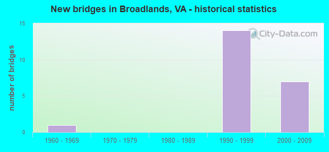
- New bridges - historical statistics
- 11960-1969
- 141990-1999
- 72000-2009

- Reconstructed bridges - Historical Statistics
- 11990-1999
- 12000-2009


- Bridge Condition - Deck
- 14.3%Very good
- 57.1%Good
- 14.3%Satisfactory
- 14.3%Fair

- Bridge Condition - Superstructure
- 12.5%Very good
- 50.0%Good
- 12.5%Satisfactory
- 25.0%Fair

- Bridge Condition - Substructure
- 37.5%Very good
- 50.0%Good
- 12.5%Satisfactory

- Bridge Condition - Channel
- 20.0%Very good
- 50.0%Good
- 30.0%Satisfactory

- Bridge Condition - Culverts
- 80.0%Good
- 20.0%Satisfactory
Find on map >> Show street view
Structure Number: 11211, Location: 00.91FR.648/00.75TO659 (Lat: 39.039589, Lng: -77.534808), Route carried "on" structure: County highway 643, Year Built: 1969, Status: Open, Structure Length: 11.13m (36.52ft), Average Daily Traffic: 9,288 (year 2020), Truck Traffic: 6%, Average Future Daily Traffic: 13,003 (year 2040), Design Load: HS 20, Features Intersected: GOOSE CREEK, Facility Carried by Structure: SYCOLIN ROAD
Minimum Vertical Clearance: 30+ m (98+ ft), Kilometerpoint: 7.691, Lanes on structure: 2, Owner: State Highway Agency, Approaching Roadway Width: 8.5m (27.9ft), Skew: 3 degrees, Material/Design: Steel, Design/Construction: Stringer/Multi-beam, Number Of Spans In Main Unit: 5, Length of Maximum Span: 22.6m (74.1ft), Curb or Sidewalk Widths: Left: 0.2m (0.7ft), Right: 0.2m (0.7ft), Curb-To-Curb Width: 7.8m (25.6ft), Out-to-Out Width: 8.8m (28.9ft)
Condition: Deck: Fair, Superstructure: Fair, Substructure: Good, Channel: Satisfactory, Operating Rating: 86.2 metric tons, Method Used To Determine Operating Rating: Load and Resistance Factor (LRFR), Inventory Rating: 66.3 metric tons, Method Used To Determine Inventory Rating: Load and Resistance Factor (LRFR), Structural Evaluation: Somewhat better than minimum adequacy, Deck Geometry: High priority of replacement, Waterway Adequacy: Somewhat better than minimum adequacy, Approach Roadway Alignment: Equal to present minimum criteria, Length Of Structure Improvement: 11.13m (36.52ft), Designated Inspection Frequency: Every 24 months, Underwater Inspection Frequency: Every 60 months, Inspection Date: September 2021, Underwater Inspection Date: September 2020, Bridge Improvement Cost: $250,000, Roadway Improvement Cost: $20,000, Total Project Cost: $271,000, Deck Structure Type: Concrete Cast-file-Place
Find on map >> Show street view
Structure Number: 24041, Location: 01.55FR659/00.70TO772 (Lat: 39.016244, Lng: -77.506183), Route carried "on" structure: County highway 625, Year Built: 1994, Year Reconstructed: 2002, Status: Open, Structure Length: 7.16m (23.49ft), Average Daily Traffic: 7,987 (year 2020), Truck Traffic: 1%, Average Future Daily Traffic: 11,182 (year 2040), Design Load: HS 20, Features Intersected: DULLES GREENWAY, Facility Carried by Structure: WAXPOOL ROAD
Minimum Vertical Clearance: 30+ m (98+ ft), Kilometerpoint: 0.000, Lanes on structure: 4, Lanes under structure: 6, Owner: State Highway Agency, Approaching Roadway Width: 14.6m (47.9ft), Skew: 2 degrees, Material/Design: Steel continuous, Design/Construction: Stringer/Multi-beam, Number Of Spans In Main Unit: 2, Length of Maximum Span: 35.4m (116.1ft), Curb or Sidewalk Widths: Left: 1.8m (5.9ft), Right: 1.8m (5.9ft), Curb-To-Curb Width: 14.6m (47.9ft), Out-to-Out Width: 21.3m (69.9ft)
Condition: Deck: Good, Superstructure: Fair, Substructure: Satisfactory, Operating Rating: 54.0 metric tons, Method Used To Determine Operating Rating: Load and Resistance Factor (LRFR), Inventory Rating: 41.6 metric tons, Method Used To Determine Inventory Rating: Load and Resistance Factor (LRFR), Structural Evaluation: Somewhat better than minimum adequacy, Deck Geometry: High priority of replacement, Underclear: Superior to present desirable criteria, Approach Roadway Alignment: Equal to present desirable criteria, Length Of Structure Improvement: 7.16m (23.49ft), Designated Inspection Frequency: Every 24 months, Inspection Date: August 2020, Bridge Improvement Cost: $79,000, Roadway Improvement Cost: $125,000, Total Project Cost: $300,000 ( Estimate for 2014), Deck Structure Type: Concrete Cast-file-Place, Wearing Surface/Protective System: Deck Protection: Epoxy Coated Reinforcing
Find on map >> Show street view
Structure Number: 24459, Location: 01.83FR625/00.30TO640 (Lat: 39.036533, Lng: -77.523114), Route carried "on" structure: County highway 659, Year Built: 1995, Status: Open, Structure Length: 10.97m (35.99ft), Average Daily Traffic: 13,637 (year 2020), Truck Traffic: 4%, Average Future Daily Traffic: 19,092 (year 2040), Design Load: HS 20, Features Intersected: DULLES GREENWAY & RAMP D, Facility Carried by Structure: BELMONT RIDGE ROAD
Minimum Vertical Clearance: 30+ m (98+ ft), Kilometerpoint: 0.000, Lanes on structure: 3, Lanes under structure: 7, Owner: State Highway Agency, Approaching Roadway Width: 17.1m (56.1ft), Skew: 1 degrees, Material/Design: Steel continuous, Design/Construction: Stringer/Multi-beam, Number Of Spans In Main Unit: 4, Length of Maximum Span: 31.1m (102.0ft), Curb-To-Curb Width: 18.3m (60.0ft), Out-to-Out Width: 19.4m (63.6ft)
Condition: Deck: Good, Superstructure: Good, Substructure: Good, Operating Rating: 47.2 metric tons, Method Used To Determine Operating Rating: Load and Resistance Factor (LRFR), Inventory Rating: 36.3 metric tons, Method Used To Determine Inventory Rating: Load and Resistance Factor (LRFR), Structural Evaluation: Better than present minimum criteria, Deck Geometry: Superior to present desirable criteria, Underclear: Equal to present minimum criteria, Approach Roadway Alignment: Equal to present desirable criteria, Length Of Structure Improvement: 10.97m (35.99ft), Designated Inspection Frequency: Every 24 months, Inspection Date: November 2021, Bridge Improvement Cost: $55,000, Roadway Improvement Cost: $100,000, Total Project Cost: $250,000, Deck Structure Type: Concrete Cast-file-Place, Wearing Surface/Protective System: Wearing Surface: Monolithic Concrete, Deck Protection: Epoxy Coated Reinforcing
Find on map >> Show street view
Structure Number: 2453, Location: 00.46FR659/00.45TO901 (Lat: 39.034214, Lng: -77.515203), Route carried "on" structure: Other road 267, Year Built: 1995, Status: Open, Structure Length: 0.98m (3.22ft), Average Daily Traffic: 33,966 (year 2020), Truck Traffic: 2%, Average Future Daily Traffic: 45,851 (year 2040), Design Load: HS 20, Features Intersected: TRIB. BEAVERDAM RUN, Facility Carried by Structure: DULLES GREENWAY
Minimum Vertical Clearance: 30+ m (98+ ft), Kilometerpoint: 9.702, Lanes on structure: 6, Base Highway Network: Yes, Toll: On toll road, Owner: Local Toll Authority, Approaching Roadway Width: 31.7m (104.0ft), Material/Design: Concrete, Design/Construction: Culvert, Number Of Spans In Main Unit: 3, Length of Maximum Span: 3.0m (9.8ft)
Condition: Channel: Satisfactory, Culverts: Satisfactory, Operating Rating: 89.8 metric tons, Method Used To Determine Operating Rating: Load Factor (LF), Inventory Rating: 78.0 metric tons, Method Used To Determine Inventory Rating: Load Factor (LF), Structural Evaluation: Equal to present minimum criteria, Waterway Adequacy: Better than present minimum criteria, Approach Roadway Alignment: Equal to present desirable criteria, Length Of Structure Improvement: 0.30m (0.98ft), Designated Inspection Frequency: Every 24 months, Inspection Date: August 2020, Bridge Improvement Cost: $1,000, Roadway Improvement Cost: $1,000, Total Project Cost: $3,000 ( Estimate for 2016)
Find on map >> Show street view
Structure Number: 24535, Location: 00.79FR901/00.86TO772 (Lat: 39.019197, Lng: -77.506153), Route carried "on" structure: Other road 267, Year Built: 1995, Status: Open, Structure Length: 0.64m (2.10ft), Average Daily Traffic: 38,455 (year 2020), Truck Traffic: 2%, Average Future Daily Traffic: 39,099 (year 2040), Design Load: HS 20+Mod, Features Intersected: TRIB. BEAVERDAM RUN, Facility Carried by Structure: DULLES GREENWAY
Minimum Vertical Clearance: 30+ m (98+ ft), Kilometerpoint: 11.891, Lanes on structure: 4, Base Highway Network: Yes, Toll: On toll road, Owner: Local Toll Authority, Approaching Roadway Width: 24.1m (79.1ft), Material/Design: Concrete, Design/Construction: Culvert, Number Of Spans In Main Unit: 2, Length of Maximum Span: 3.0m (9.8ft)
Condition: Channel: Satisfactory, Culverts: Good, Operating Rating: 89.8 metric tons, Method Used To Determine Operating Rating: Load Factor (LF), Inventory Rating: 71.7 metric tons, Method Used To Determine Inventory Rating: Load Factor (LF), Structural Evaluation: Better than present minimum criteria, Waterway Adequacy: Better than present minimum criteria, Approach Roadway Alignment: Equal to present desirable criteria, Length Of Structure Improvement: 0.30m (0.98ft), Designated Inspection Frequency: Every 24 months, Inspection Date: August 2020, Bridge Improvement Cost: $1,000, Roadway Improvement Cost: $1,000, Total Project Cost: $3,000 ( Estimate for 2016)
Find on map >> Show street view
Structure Number: 24565, Location: 00.52FR901/01.10TO772 (Lat: 39.024886, Lng: -77.506128), Route carried "on" structure: Other road 267, Year Built: 1995, Year Reconstructed: 2005, Status: Open, Structure Length: 4.85m (15.91ft), Average Daily Traffic: 19,481 (year 2020), Truck Traffic: 2%, Average Future Daily Traffic: 27,273 (year 2040), Design Load: HS 20+Mod, Features Intersected: BROADLANDS BLVD., Facility Carried by Structure: DULLES GREENWAY EB
Minimum Vertical Clearance: 30+ m (98+ ft), Kilometerpoint: 11.102, Lanes on structure: 4, Lanes under structure: 4, Base Highway Network: Yes, Toll: On toll road, Owner: Local Toll Authority, Approaching Roadway Width: 22.9m (75.1ft), Material/Design: Steel continuous, Design/Construction: Stringer/Multi-beam, Number Of Spans In Main Unit: 2, Length of Maximum Span: 24.4m (80.1ft), Curb-To-Curb Width: 22.6m (74.1ft), Out-to-Out Width: 23.6m (77.4ft)
Condition: Deck: Satisfactory, Superstructure: Satisfactory, Substructure: Good, Operating Rating: 90.6 metric tons, Method Used To Determine Operating Rating: Load and Resistance Factor (LRFR), Inventory Rating: 83.4 metric tons, Method Used To Determine Inventory Rating: Load and Resistance Factor (LRFR), Structural Evaluation: Equal to present minimum criteria, Deck Geometry: Superior to present desirable criteria, Approach Roadway Alignment: Equal to present desirable criteria, Length Of Structure Improvement: 0.30m (0.98ft), Designated Inspection Frequency: Every 24 months, Inspection Date: November 2020, Bridge Improvement Cost: $1,000, Roadway Improvement Cost: $1,000, Total Project Cost: $3,000 ( Estimate for 2014), Deck Structure Type: Concrete Cast-file-Place, Wearing Surface/Protective System: Wearing Surface: Monolithic Concrete, Deck Protection: Epoxy Coated Reinforcing
Find on map >> Show street view
Structure Number: 26724, Location: 00.35FR END/00.15TO625 (Lat: 39.014589, Lng: -77.511842), Route carried "on" structure: County highway 901, Year Built: 2000, Status: Open, Structure Length: 1.10m (3.61ft), Average Daily Traffic: 13,000 (year 2009), Average Future Daily Traffic: 15,015 (year 2040), Design Load: HS 20, Features Intersected: TRIB. OF BEAVERDAM RUN, Facility Carried by Structure: CLAIBORNE PARKWAY
Minimum Vertical Clearance: 30.18m (99.02ft), Kilometerpoint: 0.000, Lanes on structure: 4, Owner: State Highway Agency, Approaching Roadway Width: 8.2m (26.9ft), Skew: 20 degrees, Material/Design: Concrete, Design/Construction: Arch - Deck, Number Of Spans In Main Unit: 1, Length of Maximum Span: 11.0m (36.1ft), Curb or Sidewalk Widths: Left: 0.0m, Right: 1.8m (5.9ft), Curb-To-Curb Width: 8.2m (26.9ft), Out-to-Out Width: 45.7m (149.9ft)
Condition: Deck: Good, Superstructure: Good, Substructure: Very good, Channel: Good, Operating Rating: 89.9 metric tons, Method Used To Determine Operating Rating: Load and Resistance Factor (LRFR), Inventory Rating: 89.8 metric tons, Method Used To Determine Inventory Rating: Load and Resistance Factor (LRFR), Structural Evaluation: Better than present minimum criteria, Deck Geometry: High priority of replacement, Waterway Adequacy: Equal to present desirable criteria, Approach Roadway Alignment: Better than present minimum criteria, Designated Inspection Frequency: Every 24 months, Inspection Date: May 2020
Find on map >> Show street view
Structure Number: 26741, Location: 00.02FR END/00.52TO625 (Lat: 39.009081, Lng: -77.512781), Route carried "on" structure: County highway 901, Year Built: 2000, Status: Open, Structure Length: 0.91m (2.99ft), Average Daily Traffic: 13,000 (year 2009), Average Future Daily Traffic: 21,060 (year 2040), Design Load: HS 20+Mod, Features Intersected: TRIB. OF BEAVERDAM RUN, Facility Carried by Structure: CLAIBORNE PARKWAY
Minimum Vertical Clearance: 30.18m (99.02ft), Kilometerpoint: 0.000, Lanes on structure: 6, Owner: State Highway Agency, Approaching Roadway Width: 8.5m (27.9ft), Material/Design: Concrete, Design/Construction: Arch - Deck, Number Of Spans In Main Unit: 2, Length of Maximum Span: 4.3m (14.1ft), Curb or Sidewalk Widths: Left: 2.4m (7.9ft), Right: 2.4m (7.9ft), Curb-To-Curb Width: 8.5m (27.9ft), Out-to-Out Width: 41.8m (137.1ft)
Condition: Deck: Very good, Superstructure: Very good, Substructure: Very good, Channel: Very good, Operating Rating: 40.0 metric tons, Method Used To Determine Operating Rating: Field evaluation and documented engineering judgment, Inventory Rating: 29.4 metric tons, Method Used To Determine Inventory Rating: Field evaluation and documented engineering judgment, Structural Evaluation: Better than present minimum criteria, Deck Geometry: High priority of replacement, Waterway Adequacy: Better than present minimum criteria, Approach Roadway Alignment: Better than present minimum criteria, Designated Inspection Frequency: Every 24 months, Inspection Date: August 2020
Find on map >> Show street view
Structure Number: 26794, Location: 00.30FR0000/00.10TO0000 (Lat: 39.030622, Lng: -77.515233), Route carried "on" structure: County highway 640, Year Built: 2001, Status: Open, Structure Length: 0.67m (2.20ft), Average Daily Traffic: 6,600 (year 2014), Average Future Daily Traffic: 10,032 (year 2040), Design Load: HS 20, Features Intersected: TRIB. OF BEAVERDAM RUN, Facility Carried by Structure: BROADLANDS BLVD.
Minimum Vertical Clearance: 30.18m (99.02ft), Kilometerpoint: 0.000, Lanes on structure: 5, Owner: State Highway Agency, Approaching Roadway Width: 7.9m (25.9ft), Skew: 2 degrees, Material/Design: Concrete, Design/Construction: Culvert, Number Of Spans In Main Unit: 3, Length of Maximum Span: 1.5m (4.9ft)
Condition: Channel: Good, Culverts: Good, Operating Rating: 84.4 metric tons, Method Used To Determine Operating Rating: Load Factor (LF), Inventory Rating: 50.8 metric tons, Method Used To Determine Inventory Rating: Load Factor (LF), Structural Evaluation: Better than present minimum criteria, Waterway Adequacy: Better than present minimum criteria, Approach Roadway Alignment: Better than present minimum criteria, Designated Inspection Frequency: Every 24 months, Inspection Date: September 2020
Find on map >> Show street view
Structure Number: 27205, Location: 00.08FRCLAI/00.10TOMAPLE (Lat: 39.009467, Lng: -77.514242), Route carried "on" structure: County highway 2600, Year Built: 2001, Status: Open, Structure Length: 0.79m (2.59ft), Average Daily Traffic: 3,500 (year 2009), Average Future Daily Traffic: 5,670 (year 2040), Design Load: HS 20, Features Intersected: TRIB. OF BEAVERDAM RUN, Facility Carried by Structure: RIDGEWAY DR.
Minimum Vertical Clearance: 30.18m (99.02ft), Kilometerpoint: 0.000, Lanes on structure: 2, Owner: State Highway Agency, Approaching Roadway Width: 11.3m (37.1ft), Skew: 2 degrees, Material/Design: Concrete, Design/Construction: Culvert, Number Of Spans In Main Unit: 3, Length of Maximum Span: 2.4m (7.9ft)
Condition: Channel: Good, Culverts: Good, Operating Rating: 86.2 metric tons, Method Used To Determine Operating Rating: Load Factor (LF), Inventory Rating: 51.7 metric tons, Method Used To Determine Inventory Rating: Load Factor (LF), Structural Evaluation: Better than present minimum criteria, Waterway Adequacy: Better than present minimum criteria, Approach Roadway Alignment: Better than present minimum criteria, Designated Inspection Frequency: Every 24 months, Inspection Date: May 2020
Find on map >> Show street view
Structure Number: 28471, Location: 00.20FR0641/00.20TOFULLER (Lat: 39.019936, Lng: -77.497828), Route carried "on" structure: County highway 643, Year Built: 2008, Status: Open, Structure Length: 1.58m (5.18ft), Average Daily Traffic: 5,225 (year 2020), Truck Traffic: 1%, Average Future Daily Traffic: 7,315 (year 2040), Design Load: HS 20, Features Intersected: BEAVERDAM RUN, Facility Carried by Structure: SHELLHORN RD.
Minimum Vertical Clearance: 30+ m (98+ ft), Kilometerpoint: 0.000, Lanes on structure: 5, Owner: State Highway Agency, Approaching Roadway Width: 7.9m (25.9ft), Skew: 20 degrees, Material/Design: Concrete, Design/Construction: Arch - Deck, Number Of Spans In Main Unit: 2, Length of Maximum Span: 7.3m (24.0ft), Curb or Sidewalk Widths: Left: 0.0m, Right: 1.2m (3.9ft), Curb-To-Curb Width: 18.3m (60.0ft), Out-to-Out Width: 35.1m (115.2ft)
Condition: Deck: Good, Superstructure: Good, Substructure: Very good, Channel: Good, Operating Rating: 84.3 metric tons, Method Used To Determine Operating Rating: Load Factor (LF), Inventory Rating: 47.4 metric tons, Method Used To Determine Inventory Rating: Load Factor (LF), Structural Evaluation: Better than present minimum criteria, Deck Geometry: High priority of replacement, Waterway Adequacy: Equal to present desirable criteria, Approach Roadway Alignment: Equal to present desirable criteria, Length Of Structure Improvement: 1.59m (5.22ft), Designated Inspection Frequency: Every 24 months, Inspection Date: May 2021, Bridge Improvement Cost: $67,000, Roadway Improvement Cost: $100,000, Total Project Cost: $175,000 ( Estimate for 2015)
Find on map >> Show street view
Structure Number: 28697, Location: 00.10FR0772/00.15TOMOOREV (Lat: 39.003008, Lng: -77.501867), Route carried "on" structure: County highway 645, Year Built: 2007, Status: Open, Structure Length: 0.79m (2.59ft), Average Daily Traffic: 4,632 (year 2020), Average Future Daily Traffic: 5,948 (year 2040), Design Load: HS 20, Features Intersected: BR. OF BEAVERDAM RUN, Facility Carried by Structure: CROSON LANE
Minimum Vertical Clearance: 30+ m (98+ ft), Kilometerpoint: 0.000, Lanes on structure: 2, Base Highway Network: Yes, Owner: State Highway Agency, Approaching Roadway Width: 7.3m (24.0ft), Skew: 1 degrees, Material/Design: Concrete, Design/Construction: Arch - Deck, Number Of Spans In Main Unit: 1, Length of Maximum Span: 7.3m (24.0ft), Curb-To-Curb Width: 7.3m (24.0ft), Out-to-Out Width: 18.3m (60.0ft)
Condition: Superstructure: Good, Substructure: Good, Channel: Very good, Operating Rating: 63.8 metric tons, Method Used To Determine Operating Rating: Load Factor (LF), Inventory Rating: 41.0 metric tons, Method Used To Determine Inventory Rating: Load Factor (LF), Structural Evaluation: Better than present minimum criteria, Deck Geometry: High priority of replacement, Waterway Adequacy: Equal to present desirable criteria, Approach Roadway Alignment: Equal to present desirable criteria, Length Of Structure Improvement: 0.73m (2.40ft), Designated Inspection Frequency: Every 24 months, Inspection Date: January 2022, Bridge Improvement Cost: $25,000, Roadway Improvement Cost: $40,000, Total Project Cost: $75,000 ( Estimate for 2014)
Find on map >> Show street view
Structure Number: 30529, Location: 0.60FR.WxplRd/.10TOMorPky (Lat: 39.009806, Lng: -77.502333), Route carried "on" structure: County highway 2070, Year Built: 2005, Status: Open, Structure Length: 0.98m (3.22ft), Average Daily Traffic: 8,000 (year 2014), Truck Traffic: 1%, Average Future Daily Traffic: 18,000 (year 2034), Design Load: HS 20, Features Intersected: Trib. of Beaverdam Run, Facility Carried by Structure: DEMOTT DRIVE
Minimum Vertical Clearance: 30.18m (99.02ft), Kilometerpoint: 0.000, Lanes on structure: 5, Owner: State Highway Agency, Approaching Roadway Width: 18.9m (62.0ft), Material/Design: Concrete, Design/Construction: Culvert, Number Of Spans In Main Unit: 4, Length of Maximum Span: 2.4m (7.9ft)
Condition: Channel: Good, Culverts: Good, Operating Rating: 88.0 metric tons, Method Used To Determine Operating Rating: Load Factor (LF), Inventory Rating: 52.6 metric tons, Method Used To Determine Inventory Rating: Load Factor (LF), Structural Evaluation: Better than present minimum criteria, Waterway Adequacy: Better than present minimum criteria, Approach Roadway Alignment: Better than present minimum criteria, Designated Inspection Frequency: Every 24 months, Inspection Date: June 2021
Find on map >> Show street view
Structure Number: 24041, Location: 01.55FR659/00.70TO772 (Lat: 39.016244, Lng: -77.506183), Route carried "under" structure: Other road 267, Year Built: 1994, Structure Length: 0. m, Average Daily Traffic: 17,000 (year 1994), Features Intersected: DULLES GREENWAY, Facility Carried by Structure: WAXPOOL ROAD
Minimum Vertical Clearance: 5.54m (18.18ft), Kilometerpoint: 12.068, Lanes on structure: 4, Lanes under structure: 3, Toll: On toll road, Material/Design: Steel continuous, Design/Construction: Stringer/Multi-beam, Length of Maximum Span: 35.4m (116.1ft)
Find on map >> Show street view
Structure Number: 24041, Location: 01.55FR659/00.70TO772 (Lat: 39.016244, Lng: -77.506183), Route carried "under" structure: Other road 267, Year Built: 1994, Structure Length: 0. m, Average Daily Traffic: 8,500 (year 1994), Features Intersected: DULLES GREENWAY, Facility Carried by Structure: WAXPOOL ROAD
Minimum Vertical Clearance: 5.82m (19.09ft), Kilometerpoint: 12.068, Lanes on structure: 4, Lanes under structure: 3, Toll: On toll road, Material/Design: Steel continuous, Design/Construction: Stringer/Multi-beam, Length of Maximum Span: 35.4m (116.1ft)
Find on map >> Show street view
Structure Number: 24459, Location: 01.83FR625/00.30TO640 (Lat: 39.036533, Lng: -77.523114), Route carried "under" structure: Other road 267, Year Built: 1995, Structure Length: 0. m, Average Daily Traffic: 5,000 (year 1994), Features Intersected: DULLES GREENWAY & RAMP D, Facility Carried by Structure: BELMONT RIDGE ROAD
Minimum Vertical Clearance: 7.01m (23.00ft), Kilometerpoint: 9.010, Lanes on structure: 3, Lanes under structure: 3, Toll: On toll road, Material/Design: Steel continuous, Design/Construction: Stringer/Multi-beam, Length of Maximum Span: 31.1m (102.0ft)
Find on map >> Show street view
Structure Number: 24459, Location: 01.83FR625/00.30TO640 (Lat: 39.036533, Lng: -77.523114), Route carried "under" structure: Ramp Other road 267, Year Built: 1995, Structure Length: 0. m, Average Daily Traffic: 1,000 (year 1994), Features Intersected: DULLES GREENWAY & RAMP D, Facility Carried by Structure: BELMONT RIDGE ROAD
Minimum Vertical Clearance: 6.71m (22.01ft), Kilometerpoint: 9.010, Lanes on structure: 3, Lanes under structure: 1, Toll: On toll road, Material/Design: Steel continuous, Design/Construction: Stringer/Multi-beam, Length of Maximum Span: 31.1m (102.0ft)
Find on map >> Show street view
Structure Number: 24459, Location: 01.83FR625/00.30TO640 (Lat: 39.036533, Lng: -77.523114), Route carried "under" structure: ServiceOther road 267, Year Built: 1995, Structure Length: 0. m, Average Daily Traffic: 5,000 (year 1994), Features Intersected: DULLES GREENWAY & RAMP D, Facility Carried by Structure: BELMONT RIDGE ROAD
Minimum Vertical Clearance: 7.24m (23.75ft), Kilometerpoint: 9.010, Lanes on structure: 3, Lanes under structure: 3, Toll: On toll road, Material/Design: Steel continuous, Design/Construction: Stringer/Multi-beam, Length of Maximum Span: 31.1m (102.0ft)
Find on map >> Show street view
Structure Number: 2456, Location: 00.90FR659/01.60TO772 (Lat: 39.030408, Lng: -77.508639), Route carried "under" structure: County highway 901, Year Built: 1995, Structure Length: 0. m, Average Daily Traffic: 500 (year 1994), Features Intersected: CLAIBORNE PARKWAY, Facility Carried by Structure: DULLES GREENWAY EB
Minimum Vertical Clearance: 5.49m (18.01ft), Kilometerpoint: 0.000, Lanes on structure: 2, Lanes under structure: 2, Material/Design: Steel, Design/Construction: Stringer/Multi-beam, Length of Maximum Span: 41.5m (136.2ft)
Find on map >> Show street view
Structure Number: 2456, Location: 00.90FR659/01.60TO772 (Lat: 39.030408, Lng: -77.508639), Route carried "under" structure: County highway 901, Year Built: 1995, Structure Length: 0. m, Average Daily Traffic: 500 (year 1994), Features Intersected: CLAIBORNE PARKWAY, Facility Carried by Structure: DULLES GREENWAY EB
Minimum Vertical Clearance: 5.28m (17.32ft), Kilometerpoint: 0.000, Lanes on structure: 2, Lanes under structure: 3, Material/Design: Steel, Design/Construction: Stringer/Multi-beam, Length of Maximum Span: 41.5m (136.2ft)
Find on map >> Show street view
Structure Number: 24565, Location: 00.52FR901/01.10TO772 (Lat: 39.024886, Lng: -77.506128), Route carried "under" structure: County highway 2363, Year Built: 1995, Structure Length: 0. m, Average Daily Traffic: 5,000 (year 2009), Truck Traffic: 5%, Features Intersected: BROADLANDS BLVD., Facility Carried by Structure: DULLES GREENWAY EB
Minimum Vertical Clearance: 5.81m (19.06ft), Kilometerpoint: 0.000, Lanes on structure: 4, Lanes under structure: 2, Material/Design: Steel continuous, Design/Construction: Stringer/Multi-beam, Length of Maximum Span: 24.4m (80.1ft)
Find on map >> Show street view
Structure Number: 24565, Location: 00.52FR901/01.10TO772 (Lat: 39.024886, Lng: -77.506128), Route carried "under" structure: County highway 2363, Year Built: 1995, Structure Length: 0. m, Average Daily Traffic: 5,000 (year 2009), Truck Traffic: 5%, Features Intersected: BROADLANDS BLVD., Facility Carried by Structure: DULLES GREENWAY EB
Minimum Vertical Clearance: 5.92m (19.42ft), Kilometerpoint: 0.000, Lanes on structure: 4, Lanes under structure: 2, Material/Design: Steel continuous, Design/Construction: Stringer/Multi-beam, Length of Maximum Span: 24.4m (80.1ft)