Bridge Statistics for Burien, Washington (WA)
Condition, Traffic, Stress, Structural Evaluation, Project Costs
- National Bridge Inventory (NBI) Statistics
- 22Number of bridges
- 272ft / 83.0mTotal length
- $74,715,000Total costs
- 680,061Total average daily traffic
- 23,060Total average daily truck traffic
- National Bridge Inventory (NBI) Registered Bridges for Burien
- No street view available for this location
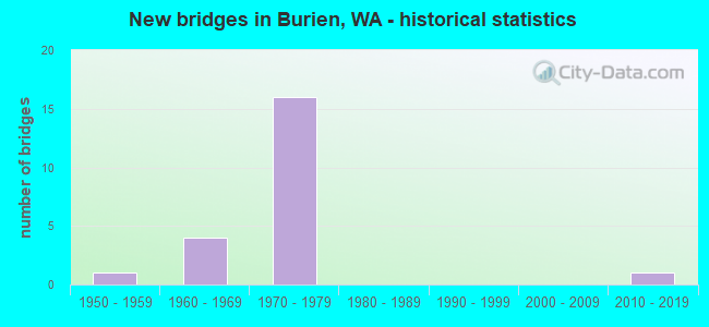
- New bridges - historical statistics
- 11950-1959
- 41960-1969
- 161970-1979
- 12010-2019
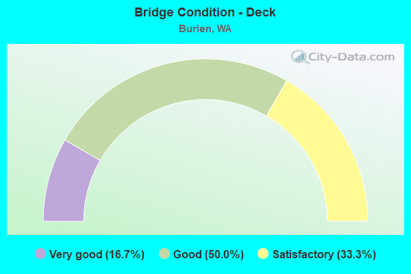
- Bridge Condition - Deck
- 16.7%Very good
- 50.0%Good
- 33.3%Satisfactory
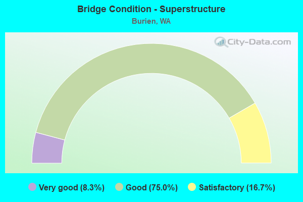
- Bridge Condition - Superstructure
- 8.3%Very good
- 75.0%Good
- 16.7%Satisfactory
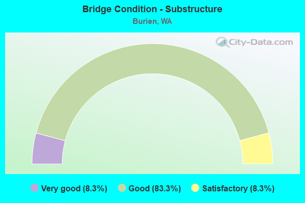
- Bridge Condition - Substructure
- 8.3%Very good
- 83.3%Good
- 8.3%Satisfactory
Find on map >> Show street view
Structure Number: 8276C, Location: 1.3 N JCT SR 518 (Lat: 47.488358, Lng: -122.326142), Route carried "on" structure: State highway 509, Year Built: 1968, Status: Open, Structure Length: 6.19m (20.31ft), Average Daily Traffic: 45,683 (year 2019), Truck Traffic: 2%, Average Future Daily Traffic: 64,504 (year 2039), Design Load: HS 20, Features Intersected: S 128TH ST
Minimum Vertical Clearance: 30+ m (98+ ft), Kilometerpoint: 43.227, Lanes on structure: 4, Lanes under structure: 6, Base Highway Network: Yes, Owner: State Highway Agency, Approaching Roadway Width: 25.0m (82.0ft), Skew: 31 degrees, Material/Design: Prestressed concrete continuous, Design/Construction: Stringer/Multi-beam, Number Of Spans In Main Unit: 3, Length of Maximum Span: 32.9m (107.9ft), Curb or Sidewalk Widths: Left: 0.2m (0.7ft), Right: 0.2m (0.7ft), Curb-To-Curb Width: 25.0m (82.0ft), Out-to-Out Width: 25.9m (85.0ft)
Condition: Deck: Satisfactory, Superstructure: Satisfactory, Substructure: Good, Operating Rating: 60.8 metric tons, Method Used To Determine Operating Rating: Load Factor (LF), Inventory Rating: 36.3 metric tons, Method Used To Determine Inventory Rating: Load Factor (LF), Structural Evaluation: Equal to present minimum criteria, Deck Geometry: Superior to present desirable criteria, Underclear: Equal to present minimum criteria, Approach Roadway Alignment: Equal to present desirable criteria, Length Of Structure Improvement: 6.19m (20.31ft), Designated Inspection Frequency: Every 24 months, Inspection Date: May 2021, Bridge Improvement Cost: $3,410,000, Roadway Improvement Cost: $682,000, Total Project Cost: $6,821,000 ( Estimate for 2014), Deck Structure Type: Concrete Cast-file-Place, Wearing Surface/Protective System: Wearing Surface: Monolithic Concrete
Find on map >> Show street view
Structure Number: 8592A, Location: 0.8 N JCT SR 518 (Lat: 47.481250, Lng: -122.327722), Route carried "on" structure: County highway , Year Built: 1969, Status: Open, Structure Length: 6.37m (20.90ft), Average Daily Traffic: 7,669 (year 2010), Truck Traffic: 4%, Average Future Daily Traffic: 12,378 (year 2032), Design Load: HS 20+Mod, Features Intersected: SR 509, Facility Carried by Structure: S136TH ST
Minimum Vertical Clearance: 30+ m (98+ ft), Kilometerpoint: 1.545, Lanes on structure: 2, Lanes under structure: 4, Owner: State Highway Agency, Approaching Roadway Width: 14.0m (45.9ft), Material/Design: Prestressed concrete continuous, Design/Construction: Stringer/Multi-beam, Number Of Spans In Main Unit: 4, Length of Maximum Span: 18.0m (59.1ft), Curb or Sidewalk Widths: Left: 1.5m (4.9ft), Right: 1.5m (4.9ft), Curb-To-Curb Width: 13.4m (44.0ft), Out-to-Out Width: 17.0m (55.8ft)
Condition: Deck: Good, Superstructure: Good, Substructure: Good, Operating Rating: 61.7 metric tons, Method Used To Determine Operating Rating: Load Factor (LF), Inventory Rating: 36.3 metric tons, Method Used To Determine Inventory Rating: Load Factor (LF), Structural Evaluation: Better than present minimum criteria, Deck Geometry: Equal to present minimum criteria, Underclear: Somewhat better than minimum adequacy, Approach Roadway Alignment: Equal to present desirable criteria, Length Of Structure Improvement: 6.37m (20.90ft), Designated Inspection Frequency: Every 24 months, Inspection Date: March 2020, Bridge Improvement Cost: $2,006,000, Roadway Improvement Cost: $401,000, Total Project Cost: $4,013,000 ( Estimate for 2014), Deck Structure Type: Concrete Cast-file-Place, Wearing Surface/Protective System: Wearing Surface: Bituminous
Find on map >> Show street view
Structure Number: 8644A, Location: 0.4 E JCT SR 509 (Lat: 47.469972, Lng: -122.323806), Route carried "on" structure: State highway 518, Year Built: 1970, Status: Open, Structure Length: 5.33m (17.49ft), Average Daily Traffic: 62,986 (year 2019), Truck Traffic: 2%, Average Future Daily Traffic: 88,936 (year 2039), Design Load: HS 20, Features Intersected: 8TH AVE
Minimum Vertical Clearance: 30+ m (98+ ft), Kilometerpoint: 0.628, Lanes on structure: 4, Lanes under structure: 2, Base Highway Network: Yes, Owner: State Highway Agency, Approaching Roadway Width: 25.6m (84.0ft), Skew: 30 degrees, Material/Design: Prestressed concrete continuous, Design/Construction: Stringer/Multi-beam, Number Of Spans In Main Unit: 3, Length of Maximum Span: 20.1m (65.9ft), Curb or Sidewalk Widths: Left: 0.2m (0.7ft), Right: 0.2m (0.7ft), Curb-To-Curb Width: 25.0m (82.0ft), Out-to-Out Width: 26.4m (86.6ft)
Condition: Deck: Satisfactory, Superstructure: Good, Substructure: Good, Operating Rating: 66.2 metric tons, Method Used To Determine Operating Rating: Load Factor (LF), Inventory Rating: 39.0 metric tons, Method Used To Determine Inventory Rating: Load Factor (LF), Structural Evaluation: Better than present minimum criteria, Deck Geometry: Superior to present desirable criteria, Underclear: Equal to present minimum criteria, Approach Roadway Alignment: Equal to present desirable criteria, Length Of Structure Improvement: 5.33m (17.49ft), Designated Inspection Frequency: Every 24 months, Inspection Date: March 2020, Bridge Improvement Cost: $3,010,000, Roadway Improvement Cost: $602,000, Total Project Cost: $6,020,000 ( Estimate for 2014), Deck Structure Type: Concrete Cast-file-Place, Wearing Surface/Protective System: Wearing Surface: Monolithic Concrete
Find on map >> Show street view
Structure Number: 8644B, Location: 0.6 E JCT SR 509 (Lat: 47.470147, Lng: -122.319364), Route carried "on" structure: State highway 518, Year Built: 1970, Status: Open, Structure Length: 7.10m (23.29ft), Average Daily Traffic: 62,986 (year 2019), Truck Traffic: 2%, Average Future Daily Traffic: 88,936 (year 2039), Design Load: HS 20, Features Intersected: DES MOINES WAY S
Minimum Vertical Clearance: 30+ m (98+ ft), Kilometerpoint: 0.966, Lanes on structure: 4, Lanes under structure: 3, Base Highway Network: Yes, Owner: State Highway Agency, Approaching Roadway Width: 24.4m (80.1ft), Skew: 34 degrees, Material/Design: Prestressed concrete continuous, Design/Construction: Stringer/Multi-beam, Number Of Spans In Main Unit: 3, Length of Maximum Span: 34.1m (111.9ft), Curb or Sidewalk Widths: Left: 0.2m (0.7ft), Right: 0.2m (0.7ft), Curb-To-Curb Width: 25.0m (82.0ft), Out-to-Out Width: 26.5m (86.9ft)
Condition: Deck: Good, Superstructure: Satisfactory, Substructure: Satisfactory, Operating Rating: 59.9 metric tons, Method Used To Determine Operating Rating: Load Factor (LF), Inventory Rating: 35.4 metric tons, Method Used To Determine Inventory Rating: Load Factor (LF), Structural Evaluation: Equal to present minimum criteria, Deck Geometry: Superior to present desirable criteria, Underclear: Equal to present minimum criteria, Approach Roadway Alignment: Equal to present desirable criteria, Length Of Structure Improvement: 7.10m (23.29ft), Designated Inspection Frequency: Every 24 months, Inspection Date: March 2020, Bridge Improvement Cost: $3,821,000, Roadway Improvement Cost: $764,000, Total Project Cost: $7,642,000 ( Estimate for 2014), Deck Structure Type: Concrete Cast-file-Place, Wearing Surface/Protective System: Wearing Surface: Bituminous
Find on map >> Show street view
Structure Number: 8745A, Location: 5.2 N JCT SR 516 (Lat: 47.459686, Lng: -122.329861), Route carried "on" structure: County highway , Year Built: 1971, Status: Open, Structure Length: 7.71m (25.30ft), Average Daily Traffic: 11,946 (year 2012), Truck Traffic: 4%, Design Load: HS 20, Features Intersected: SR 509, Facility Carried by Structure: SO 160TH ST
Minimum Vertical Clearance: 30+ m (98+ ft), Kilometerpoint: 0.113, Lanes on structure: 4, Lanes under structure: 5, Owner: State Highway Agency, Approaching Roadway Width: 20.7m (67.9ft), Skew: 22 degrees, Material/Design: Prestressed concrete continuous, Design/Construction: Stringer/Multi-beam, Number Of Spans In Main Unit: 4, Length of Maximum Span: 23.2m (76.1ft), Curb or Sidewalk Widths: Left: 1.5m (4.9ft), Right: 1.5m (4.9ft), Curb-To-Curb Width: 16.5m (54.1ft), Out-to-Out Width: 20.1m (65.9ft)
Condition: Deck: Very good, Superstructure: Good, Substructure: Good, Operating Rating: 18.5 metric tons, Method Used To Determine Operating Rating: Load and Resistance Factor Rating (LRFR) rating reported by rating factor(RF) method using HL-93 loadings, Inventory Rating: 14.3 metric tons, Method Used To Determine Inventory Rating: Load and Resistance Factor Rating (LRFR) rating reported by rating factor(RF) method using HL-93 loadings, Structural Evaluation: High priority of corrective action, Deck Geometry: Meets minimum limits, Underclear: Equal to present minimum criteria, Approach Roadway Alignment: Equal to present desirable criteria, Length Of Structure Improvement: 7.71m (25.30ft), Designated Inspection Frequency: Every 24 months, Inspection Date: July 2021, Bridge Improvement Cost: $3,542,000, Roadway Improvement Cost: $708,000, Total Project Cost: $7,084,000 ( Estimate for 2014), Deck Structure Type: Concrete Cast-file-Place, Wearing Surface/Protective System: Wearing Surface: Latex Concrete
Find on map >> Show street view
Structure Number: 8745B, Location: 6.5 N JCT SR 516 (Lat: 47.463306, Lng: -122.332000), Route carried "on" structure: City street , Year Built: 1970, Status: Open, Structure Length: 7.41m (24.31ft), Average Daily Traffic: 8,754 (year 2010), Truck Traffic: 4%, Average Future Daily Traffic: 14,129 (year 2032), Design Load: HS 20+Mod, Features Intersected: SR 509, Facility Carried by Structure: S 156TH ST
Minimum Vertical Clearance: 30+ m (98+ ft), Kilometerpoint: 6.888, Lanes on structure: 3, Lanes under structure: 4, Owner: State Highway Agency, Approaching Roadway Width: 13.4m (44.0ft), Skew: 2 degrees, Material/Design: Prestressed concrete continuous, Design/Construction: Stringer/Multi-beam, Number Of Spans In Main Unit: 4, Length of Maximum Span: 19.8m (65.0ft), Curb or Sidewalk Widths: Left: 1.5m (4.9ft), Right: 1.5m (4.9ft), Curb-To-Curb Width: 13.4m (44.0ft), Out-to-Out Width: 17.0m (55.8ft)
Condition: Deck: Good, Superstructure: Good, Substructure: Good, Operating Rating: 57.1 metric tons, Method Used To Determine Operating Rating: Load Factor (LF), Inventory Rating: 33.6 metric tons, Method Used To Determine Inventory Rating: Load Factor (LF), Structural Evaluation: Better than present minimum criteria, Deck Geometry: Somewhat better than minimum adequacy, Underclear: Somewhat better than minimum adequacy, Approach Roadway Alignment: Equal to present desirable criteria, Length Of Structure Improvement: 7.41m (24.31ft), Designated Inspection Frequency: Every 24 months, Inspection Date: March 2020, Bridge Improvement Cost: $2,236,000, Roadway Improvement Cost: $447,000, Total Project Cost: $4,471,000 ( Estimate for 2014), Deck Structure Type: Concrete Cast-file-Place, Wearing Surface/Protective System: Wearing Surface: Bituminous
Find on map >> Show street view
Structure Number: 8745C, Location: 5.7 N JCT SR 516 (Lat: 47.466917, Lng: -122.332167), Route carried "on" structure: City street , Year Built: 1971, Status: Open, Structure Length: 6.83m (22.41ft), Average Daily Traffic: 11,984 (year 2010), Truck Traffic: 4%, Average Future Daily Traffic: 18,839 (year 2036), Design Load: HS 20, Features Intersected: SR 509, Facility Carried by Structure: SO 152ND ST
Minimum Vertical Clearance: 30+ m (98+ ft), Kilometerpoint: 0.644, Lanes on structure: 2, Lanes under structure: 5, Owner: State Highway Agency, Approaching Roadway Width: 11.0m (36.1ft), Material/Design: Prestressed concrete continuous, Design/Construction: Stringer/Multi-beam, Number Of Spans In Main Unit: 4, Length of Maximum Span: 20.7m (67.9ft), Curb or Sidewalk Widths: Left: 1.5m (4.9ft), Right: 1.5m (4.9ft), Curb-To-Curb Width: 7.9m (25.9ft), Out-to-Out Width: 11.3m (37.1ft)
Condition: Deck: Good, Superstructure: Good, Substructure: Good, Operating Rating: 68.0 metric tons, Method Used To Determine Operating Rating: Load Factor (LF), Inventory Rating: 39.9 metric tons, Method Used To Determine Inventory Rating: Load Factor (LF), Structural Evaluation: Better than present minimum criteria, Deck Geometry: High priority of corrective action, Underclear: Equal to present minimum criteria, Approach Roadway Alignment: Equal to present desirable criteria, Length Of Structure Improvement: 6.83m (22.41ft), Designated Inspection Frequency: Every 24 months, Inspection Date: May 2021, Bridge Improvement Cost: $1,702,000, Roadway Improvement Cost: $340,000, Total Project Cost: $3,405,000 ( Estimate for 2014), Deck Structure Type: Concrete Cast-file-Place, Wearing Surface/Protective System: Wearing Surface: Monolithic Concrete
Find on map >> Show street view
Structure Number: 8745D, Location: 0.1 N JCT SR 518 (Lat: 47.472333, Lng: -122.331778), Route carried "on" structure: County highway , Year Built: 1970, Status: Open, Structure Length: 9.02m (29.59ft), Average Daily Traffic: 5,632 (year 2012), Truck Traffic: 4%, Design Load: HS 20, Features Intersected: SR 509, Facility Carried by Structure: SO 146TH ST
Minimum Vertical Clearance: 30+ m (98+ ft), Kilometerpoint: 0.145, Lanes on structure: 2, Lanes under structure: 8, Owner: State Highway Agency, Approaching Roadway Width: 9.1m (29.9ft), Skew: 1 degrees, Material/Design: Prestressed concrete continuous, Design/Construction: Stringer/Multi-beam, Number Of Spans In Main Unit: 4, Length of Maximum Span: 29.0m (95.1ft), Curb or Sidewalk Widths: Left: 1.5m (4.9ft), Right: 1.5m (4.9ft), Curb-To-Curb Width: 9.1m (29.9ft), Out-to-Out Width: 12.5m (41.0ft)
Condition: Deck: Good, Superstructure: Good, Substructure: Good, Operating Rating: 23.3 metric tons, Method Used To Determine Operating Rating: Load and Resistance Factor Rating (LRFR) rating reported by rating factor(RF) method using HL-93 loadings, Inventory Rating: 17.8 metric tons, Method Used To Determine Inventory Rating: Load and Resistance Factor Rating (LRFR) rating reported by rating factor(RF) method using HL-93 loadings, Structural Evaluation: Meets minimum limits, Deck Geometry: Meets minimum limits, Underclear: Somewhat better than minimum adequacy, Approach Roadway Alignment: Equal to present desirable criteria, Length Of Structure Improvement: 9.02m (29.59ft), Designated Inspection Frequency: Every 24 months, Inspection Date: March 2020, Bridge Improvement Cost: $1,894,000, Roadway Improvement Cost: $379,000, Total Project Cost: $3,789,000 ( Estimate for 2014), Deck Structure Type: Concrete Cast-file-Place, Wearing Surface/Protective System: Wearing Surface: Monolithic Concrete
Find on map >> Show street view
Structure Number: 8745E, Location: JCT SR 509 (Lat: 47.470333, Lng: -122.332139), Route carried "on" structure: State highway 518, Year Built: 1971, Status: Open, Structure Length: 7.35m (24.11ft), Average Daily Traffic: 45,470 (year 2019), Truck Traffic: 2%, Average Future Daily Traffic: 64,203 (year 2039), Design Load: HS 20, Features Intersected: SR 509
Minimum Vertical Clearance: 30+ m (98+ ft), Kilometerpoint: 0.001, Lanes on structure: 7, Lanes under structure: 5, Base Highway Network: Yes, Owner: State Highway Agency, Approaching Roadway Width: 28.7m (94.2ft), Skew: 20 degrees, Material/Design: Prestressed concrete continuous, Design/Construction: Stringer/Multi-beam, Number Of Spans In Main Unit: 4, Length of Maximum Span: 23.5m (77.1ft), Curb or Sidewalk Widths: Left: 0.2m (0.7ft), Right: 0.2m (0.7ft), Curb-To-Curb Width: 28.7m (94.2ft), Out-to-Out Width: 32.0m (105.0ft)
Condition: Deck: Satisfactory, Superstructure: Good, Substructure: Good, Operating Rating: 21.4 metric tons, Method Used To Determine Operating Rating: Load and Resistance Factor Rating (LRFR) rating reported by rating factor(RF) method using HL-93 loadings, Inventory Rating: 16.5 metric tons, Method Used To Determine Inventory Rating: Load and Resistance Factor Rating (LRFR) rating reported by rating factor(RF) method using HL-93 loadings, Structural Evaluation: Meets minimum limits, Deck Geometry: Meets minimum limits, Underclear: Meets minimum limits, Approach Roadway Alignment: Equal to present desirable criteria, Length Of Structure Improvement: 7.35m (24.11ft), Designated Inspection Frequency: Every 24 months, Inspection Date: March 2020, Bridge Improvement Cost: $4,627,000, Roadway Improvement Cost: $925,000, Total Project Cost: $9,254,000 ( Estimate for 2014), Deck Structure Type: Concrete Cast-file-Place, Wearing Surface/Protective System: Wearing Surface: Monolithic Concrete
Find on map >> Show street view
Structure Number: 11070B, Location: 5.7 N JCT SR 516 (Lat: 47.452222, Lng: -122.325028), Route carried "on" structure: State highway 509, Year Built: 1979, Status: Open, Structure Length: 5.21m (17.09ft), Average Daily Traffic: 32,847 (year 2019), Truck Traffic: 5%, Average Future Daily Traffic: 46,379 (year 2039), Design Load: HS 20+Mod, Features Intersected: SO 168TH ST
Minimum Vertical Clearance: 30+ m (98+ ft), Kilometerpoint: 39.075, Lanes on structure: 4, Lanes under structure: 2, Base Highway Network: Yes, Owner: State Highway Agency, Approaching Roadway Width: 25.6m (84.0ft), Skew: 32 degrees, Material/Design: Prestressed concrete continuous, Design/Construction: Stringer/Multi-beam, Number Of Spans In Main Unit: 3, Length of Maximum Span: 21.3m (69.9ft), Curb-To-Curb Width: 25.0m (82.0ft), Out-to-Out Width: 26.4m (86.6ft)
Condition: Deck: Satisfactory, Superstructure: Good, Substructure: Good, Operating Rating: 70.7 metric tons, Method Used To Determine Operating Rating: Load Factor (LF), Inventory Rating: 42.6 metric tons, Method Used To Determine Inventory Rating: Load Factor (LF), Structural Evaluation: Better than present minimum criteria, Deck Geometry: Superior to present desirable criteria, Underclear: Equal to present minimum criteria, Approach Roadway Alignment: Equal to present desirable criteria, Length Of Structure Improvement: 5.21m (17.09ft), Designated Inspection Frequency: Every 24 months, Inspection Date: August 2021, Bridge Improvement Cost: $2,941,000, Roadway Improvement Cost: $588,000, Total Project Cost: $5,882,000 ( Estimate for 2014), Deck Structure Type: Concrete Cast-file-Place, Wearing Surface/Protective System: Wearing Surface: Bituminous
Find on map >> Show street view
Structure Number: 11070C, Location: 5.8 N JCT SR 516 (Lat: 47.453778, Lng: -122.325833), Route carried "on" structure: State highway 509, Year Built: 1979, Status: Open, Structure Length: 9.14m (29.99ft), Average Daily Traffic: 32,847 (year 2019), Truck Traffic: 5%, Average Future Daily Traffic: 46,379 (year 2039), Design Load: HS 20+Mod, Features Intersected: DES MOINES MEMORIAL
Minimum Vertical Clearance: 30+ m (98+ ft), Kilometerpoint: 39.252, Lanes on structure: 4, Lanes under structure: 2, Base Highway Network: Yes, Owner: State Highway Agency, Approaching Roadway Width: 26.5m (86.9ft), Skew: 35 degrees, Material/Design: Prestressed concrete continuous, Design/Construction: Stringer/Multi-beam, Number Of Spans In Main Unit: 3, Length of Maximum Span: 41.1m (134.8ft), Curb-To-Curb Width: 25.0m (82.0ft), Out-to-Out Width: 28.0m (91.9ft)
Condition: Deck: Good, Superstructure: Good, Substructure: Good, Operating Rating: 64.4 metric tons, Method Used To Determine Operating Rating: Load Factor (LF), Inventory Rating: 38.1 metric tons, Method Used To Determine Inventory Rating: Load Factor (LF), Structural Evaluation: Better than present minimum criteria, Deck Geometry: Superior to present desirable criteria, Underclear: Equal to present minimum criteria, Approach Roadway Alignment: Equal to present desirable criteria, Length Of Structure Improvement: 9.14m (29.99ft), Designated Inspection Frequency: Every 24 months, Inspection Date: August 2021, Bridge Improvement Cost: $5,340,000, Roadway Improvement Cost: $1,068,000, Total Project Cost: $10,680,000 ( Estimate for 2014), Deck Structure Type: Concrete Cast-file-Place, Wearing Surface/Protective System: Wearing Surface: Monolithic Concrete
Find on map >> Show street view
Structure Number: 19078A, Location: 0.2 E JCT SR 509 (Lat: 47.469917, Lng: -122.323444), Route carried "on" structure: Ramp State highway 518, Year Built: 2018, Status: Not yet open, Structure Length: 5.36m (17.59ft), Average Daily Traffic: 5,000 (year 2016), Truck Traffic: 4%, Average Future Daily Traffic: 6,200 (year 2036), Design Load: HL 93, Features Intersected: 8TH AVE
Minimum Vertical Clearance: 30+ m (98+ ft), Kilometerpoint: 0.290, Lanes on structure: 2, Lanes under structure: 2, Owner: State Highway Agency, Approaching Roadway Width: 12.8m (42.0ft), Material/Design: Concrete, Design/Construction: Stringer/Multi-beam, Number Of Spans In Main Unit: 3, Number Of Approach Spans: 2, Length of Maximum Span: 21.0m (68.9ft), Curb-To-Curb Width: 11.9m (39.0ft), Out-to-Out Width: 12.8m (42.0ft)
Condition: Deck: Very good, Superstructure: Very good, Substructure: Very good, Operating Rating: 61.6 metric tons, Method Used To Determine Operating Rating: Load and Resistance Factor Rating (LRFR) rating reported by rating factor(RF) method using HL-93 loadings, Inventory Rating: 46.3 metric tons, Method Used To Determine Inventory Rating: Load and Resistance Factor Rating (LRFR) rating reported by rating factor(RF) method using HL-93 loadings, Structural Evaluation: Equal to present desirable criteria, Deck Geometry: Superior to present desirable criteria, Underclear: Superior to present desirable criteria, Approach Roadway Alignment: Equal to present desirable criteria, Length Of Structure Improvement: 5.67m (18.60ft), Designated Inspection Frequency: Every 24 months, Inspection Date: November 2020, Bridge Improvement Cost: $2,827,000, Roadway Improvement Cost: $565,000, Total Project Cost: $5,654,000 ( Estimate for 2014), Deck Structure Type: Concrete Cast-file-Place, Wearing Surface/Protective System: Wearing Surface: Monolithic Concrete
Find on map >> Show street view
Structure Number: 8276A, Location: 1.0 N JCT SR 518 (Lat: 47.484806, Lng: -122.327278), Route carried "under" structure: State highway 509, Year Built: 1968, Structure Length: 0. m, Average Daily Traffic: 66,106 (year 2019), Truck Traffic: 2%, Features Intersected: SR 509, Facility Carried by Structure: S 132ND ST PED
Minimum Vertical Clearance: 5.59m (18.34ft), Kilometerpoint: 42.841, Lanes under structure: 5, Material/Design: Concrete continuous, Design/Construction: Slab, Length of Maximum Span: 18.9m (62.0ft)
Find on map >> Show street view
Structure Number: 8592A, Location: 0.8 N JCT SR 518 (Lat: 47.481250, Lng: -122.327722), Route carried "under" structure: State highway 509, Year Built: 1969, Structure Length: 0. m, Average Daily Traffic: 66,106 (year 2019), Truck Traffic: 2%, Features Intersected: SR 509, Facility Carried by Structure: S136TH ST
Minimum Vertical Clearance: 5.23m (17.16ft), Kilometerpoint: 42.454, Lanes on structure: 2, Lanes under structure: 4, Material/Design: Prestressed concrete continuous, Design/Construction: Stringer/Multi-beam, Length of Maximum Span: 18.0m (59.1ft)
Find on map >> Show street view
Structure Number: 8745A, Location: 6.3 N JCT SR 516 (Lat: 47.459686, Lng: -122.329861), Route carried "under" structure: State highway 509, Year Built: 1971, Structure Length: 0. m, Average Daily Traffic: 25,471 (year 2019), Truck Traffic: 5%, Features Intersected: SR 509, Facility Carried by Structure: SO 160TH ST
Minimum Vertical Clearance: 5.64m (18.50ft), Kilometerpoint: 39.960, Lanes on structure: 4, Lanes under structure: 5, Material/Design: Prestressed concrete continuous, Design/Construction: Stringer/Multi-beam, Length of Maximum Span: 23.2m (76.1ft)
Find on map >> Show street view
Structure Number: 8745B, Location: 6.5 N JCT SR 516 (Lat: 47.463306, Lng: -122.332000), Route carried "under" structure: State highway 509, Year Built: 1970, Structure Length: 0. m, Average Daily Traffic: 39,755 (year 2019), Truck Traffic: 5%, Features Intersected: SR 509, Facility Carried by Structure: S 156TH ST
Minimum Vertical Clearance: 5.69m (18.67ft), Kilometerpoint: 40.395, Lanes on structure: 3, Lanes under structure: 4, Material/Design: Prestressed concrete continuous, Design/Construction: Stringer/Multi-beam, Length of Maximum Span: 19.8m (65.0ft)
Find on map >> Show street view
Structure Number: 8745C, Location: 6.8 N JCT SR 516 (Lat: 47.466917, Lng: -122.332167), Route carried "under" structure: State highway 509, Year Built: 1971, Structure Length: 0. m, Average Daily Traffic: 39,755 (year 2019), Truck Traffic: 5%, Features Intersected: SR 509, Facility Carried by Structure: SO 152ND ST
Minimum Vertical Clearance: 5.54m (18.18ft), Kilometerpoint: 40.813, Lanes on structure: 2, Lanes under structure: 4, Material/Design: Prestressed concrete continuous, Design/Construction: Stringer/Multi-beam, Length of Maximum Span: 20.7m (67.9ft)
Find on map >> Show street view
Structure Number: 8745D, Location: 0.1 N JCT SR 518 (Lat: 47.472333, Lng: -122.331778), Route carried "under" structure: State highway 509, Year Built: 1970, Structure Length: 0. m, Average Daily Traffic: 27,125 (year 2019), Truck Traffic: 5%, Features Intersected: SR 509, Facility Carried by Structure: SO 146TH ST
Minimum Vertical Clearance: 6.73m (22.08ft), Kilometerpoint: 41.408, Lanes on structure: 2, Lanes under structure: 5, Material/Design: Prestressed concrete continuous, Design/Construction: Stringer/Multi-beam, Length of Maximum Span: 29.0m (95.1ft)
Find on map >> Show street view
Structure Number: 8745E, Location: 7.0 N JCT SR 516 (Lat: 47.470333, Lng: -122.332139), Route carried "under" structure: State highway 509, Year Built: 1971, Structure Length: 0. m, Average Daily Traffic: 27,125 (year 2019), Truck Traffic: 5%, Features Intersected: SR 509, Facility Carried by Structure: SR 518
Minimum Vertical Clearance: 5.16m (16.93ft), Kilometerpoint: 41.199, Lanes on structure: 7, Lanes under structure: 5, Material/Design: Prestressed concrete continuous, Design/Construction: Stringer/Multi-beam, Length of Maximum Span: 23.5m (77.1ft)
Find on map >> Show street view
Structure Number: 11070A, Location: 5.2 N JCT SR 516 (Lat: 47.445189, Lng: -122.321347), Route carried "under" structure: State highway 509, Year Built: 1979, Structure Length: 0. m, Average Daily Traffic: 32,847 (year 2019), Truck Traffic: 5%, Features Intersected: SR 509, Facility Carried by Structure: CLOSED S 176TH ST
Minimum Vertical Clearance: 5.59m (18.34ft), Kilometerpoint: 38.238, Lanes under structure: 4, Material/Design: Prestressed concrete continuous, Design/Construction: Stringer/Multi-beam, Length of Maximum Span: 31.4m (103.0ft)
Find on map >> Show street view
Structure Number: 11070C, Location: 5.8 N JCT SR 516 (Lat: 47.453778, Lng: -122.325833), Route carried "under" structure: City street 509, Year Built: 1979, Structure Length: 0. m, Average Daily Traffic: 5,467 (year 1993), Truck Traffic: 3%, Features Intersected: DES MOINES MEMORIAL
Minimum Vertical Clearance: 5.08m (16.67ft), Kilometerpoint: 2.993, Lanes on structure: 4, Lanes under structure: 2, Material/Design: Prestressed concrete continuous, Design/Construction: Stringer/Multi-beam, Length of Maximum Span: 41.1m (134.8ft)
Find on map >> Show street view
Structure Number: 80634, Location: 1ST AVE S & SW 126 (Lat: 47.490653, Lng: -122.333792), Route carried "under" structure: City street 138, Year Built: 1959, Structure Length: 0. m, Average Daily Traffic: 16,500 (year 2018), Truck Traffic: 6%, Features Intersected: 1ST AVE S, Facility Carried by Structure: PEDESTRIAN OX
Minimum Vertical Clearance: 4.47m (14.67ft), Kilometerpoint: 0.001, Lanes under structure: 4, Material/Design: Wood or Timber, Design/Construction: Stringer/Multi-beam, Length of Maximum Span: 21.9m (71.9ft)