Bridge Statistics for Clovis, New Mexico (NM)
Condition, Traffic, Stress, Structural Evaluation, Project Costs
- National Bridge Inventory (NBI) Statistics
- 12Number of bridges
- 184ft / 56.5mTotal length
- $1,210,000Total costs
- 57,596Total average daily traffic
- 6,124Total average daily truck traffic
- National Bridge Inventory (NBI) Registered Bridges for Clovis
- No street view available for this location
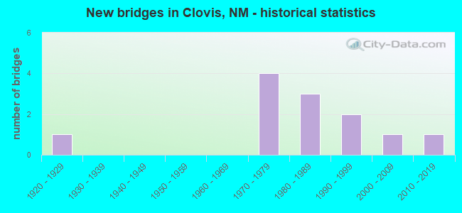
- New bridges - historical statistics
- 11920-1929
- 41970-1979
- 31980-1989
- 21990-1999
- 12000-2009
- 12010-2019


- Bridge Condition - Deck
- 62.5%Good
- 37.5%Satisfactory

- Bridge Condition - Superstructure
- 50.0%Good
- 37.5%Satisfactory
- 12.5%Fair

- Bridge Condition - Substructure
- 62.5%Good
- 25.0%Satisfactory
- 12.5%Fair

- Bridge Condition - Channel
- 33.3%Very good
- 66.7%Good
Find on map >> Show street view
Structure Number: 2043, Location: JCT-US60/THOMAS ST-CLOVIS (Lat: 34.400658, Lng: -103.231939), Route carried "on" structure: US 60, Year Built: 1929, Status: Open, Structure Length: 1.40m (4.59ft), Average Daily Traffic: 4,400 (year 2020), Truck Traffic: 8%, Average Future Daily Traffic: 5,796 (year 2040), Design Load: H 15, Features Intersected: WORTHINGTON DITCH
Minimum Vertical Clearance: 30+ m (98+ ft), Kilometerpoint: 622.076, Lanes on structure: 4, Base Highway Network: Yes, Owner: State Highway Agency, Approaching Roadway Width: 19.5m (64.0ft), Skew: 20 degrees, Material/Design: Concrete continuous, Design/Construction: Culvert, Number Of Spans In Main Unit: 4, Length of Maximum Span: 3.0m (9.8ft)
Condition: Channel: Good, Culverts: Satisfactory, Operating Rating: 51.8 metric tons, Method Used To Determine Operating Rating: Load Factor (LF), Inventory Rating: 24.3 metric tons, Method Used To Determine Inventory Rating: Load Factor (LF), Structural Evaluation: Equal to present minimum criteria, Waterway Adequacy: Equal to present desirable criteria, Approach Roadway Alignment: Equal to present desirable criteria, Designated Inspection Frequency: Every 48 months, Inspection Date: July 2021
Find on map >> Show street view
Structure Number: 6948, Location: Cannon AFB Entrance (Lat: 34.405339, Lng: -103.317656), Route carried "on" structure: State highway 6001, Year Built: 1970, Status: Open, Structure Length: 6.68m (21.92ft), Average Daily Traffic: 6,229 (year 2020), Truck Traffic: 7%, Average Future Daily Traffic: 8,765 (year 2040), Design Load: HS 20, Features Intersected: US-60
Minimum Vertical Clearance: 30+ m (98+ ft), Kilometerpoint: 0.356, Lanes on structure: 3, Lanes under structure: 5, Base Highway Network: Yes, Owner: State Highway Agency, Approaching Roadway Width: 13.9m (45.6ft), Skew: 1 degrees, Material/Design: Steel, Design/Construction: Stringer/Multi-beam, Number Of Spans In Main Unit: 3, Length of Maximum Span: 42.1m (138.1ft), Curb-To-Curb Width: 13.4m (44.0ft), Out-to-Out Width: 14.3m (46.9ft)
Condition: Deck: Satisfactory, Superstructure: Satisfactory, Substructure: Satisfactory, Operating Rating: 56.7 metric tons, Method Used To Determine Operating Rating: Load Factor (LF), Inventory Rating: 32.4 metric tons, Method Used To Determine Inventory Rating: Load Factor (LF), Structural Evaluation: Equal to present minimum criteria, Deck Geometry: Somewhat better than minimum adequacy, Underclear: Better than present minimum criteria, Approach Roadway Alignment: Somewhat better than minimum adequacy, Length Of Structure Improvement: 6.68m (21.92ft), Designated Inspection Frequency: Every 24 months, Other Special Inspection Frequency: Every 60 months, Inspection Date: October 2020, Other Special Inspection Date: October 2020, Bridge Improvement Cost: $220,000, Roadway Improvement Cost: $72,000, Total Project Cost: $380,000 ( Estimate for 2020), Deck Structure Type: Concrete Cast-file-Place
Find on map >> Show street view
Structure Number: 6949, Location: 0.1ME Jct US-60/84/NM-311 (Lat: 34.404450, Lng: -103.318042), Route carried "on" structure: State highway 6001, Year Built: 1970, Status: Open, Structure Length: 4.69m (15.39ft), Average Daily Traffic: 6,229 (year 2020), Truck Traffic: 7%, Average Future Daily Traffic: 8,765 (year 2040), Design Load: HS 20, Features Intersected: BNSF Railroad
Minimum Vertical Clearance: 30+ m (98+ ft), Kilometerpoint: 0.451, Lanes on structure: 2, Base Highway Network: Yes, Owner: State Highway Agency, Approaching Roadway Width: 15.4m (50.5ft), Skew: 1 degrees, Material/Design: Prestressed concrete, Design/Construction: Stringer/Multi-beam, Number Of Spans In Main Unit: 3, Length of Maximum Span: 20.1m (65.9ft), Curb-To-Curb Width: 16.3m (53.5ft), Out-to-Out Width: 19.2m (63.0ft)
Condition: Deck: Satisfactory, Superstructure: Satisfactory, Substructure: Satisfactory, Operating Rating: 53.9 metric tons, Method Used To Determine Operating Rating: Load Factor (LF), Inventory Rating: 31.6 metric tons, Method Used To Determine Inventory Rating: Load Factor (LF), Structural Evaluation: Equal to present minimum criteria, Deck Geometry: Superior to present desirable criteria, Underclear: Superior to present desirable criteria, Approach Roadway Alignment: Equal to present desirable criteria, Length Of Structure Improvement: 4.66m (15.29ft), Designated Inspection Frequency: Every 24 months, Inspection Date: October 2021, Bridge Improvement Cost: $180,000, Roadway Improvement Cost: $78,000, Total Project Cost: $330,000 ( Estimate for 2020), Deck Structure Type: Concrete Cast-file-Place
Find on map >> Show street view
Structure Number: 7933, Location: 9.0 MI N JCT US-70/CLOVIS (Lat: 34.529100, Lng: -103.196400), Route carried "on" structure: State highway 209, Year Built: 1978, Status: Open, Structure Length: 6.92m (22.70ft), Average Daily Traffic: 4,174 (year 2020), Truck Traffic: 22%, Average Future Daily Traffic: 6,058 (year 2040), Design Load: HS 20, Features Intersected: RUNNING WATER DRAW
Minimum Vertical Clearance: 30+ m (98+ ft), Kilometerpoint: 14.484, Lanes on structure: 2, Base Highway Network: Yes, Owner: State Highway Agency, Approaching Roadway Width: 14.6m (47.9ft), Material/Design: Prestressed concrete continuous, Design/Construction: Stringer/Multi-beam, Number Of Spans In Main Unit: 4, Length of Maximum Span: 16.8m (55.1ft), Curb-To-Curb Width: 14.6m (47.9ft), Out-to-Out Width: 15.5m (50.9ft)
Condition: Deck: Good, Superstructure: Fair, Substructure: Fair, Channel: Good, Operating Rating: 53.9 metric tons, Method Used To Determine Operating Rating: Load Factor (LF), Inventory Rating: 29.7 metric tons, Method Used To Determine Inventory Rating: Load Factor (LF), Structural Evaluation: Somewhat better than minimum adequacy, Deck Geometry: Superior to present desirable criteria, Waterway Adequacy: Equal to present desirable criteria, Approach Roadway Alignment: Equal to present desirable criteria, Designated Inspection Frequency: Every 24 months, Inspection Date: March 2021, Deck Structure Type: Concrete Cast-file-Place
Find on map >> Show street view
Structure Number: 794, Location: 0.2 M S JCT US-60/US-70 (Lat: 34.396800, Lng: -103.196400), Route carried "on" structure: US 70, Year Built: 1989, Status: Open, Structure Length: 12.77m (41.90ft), Average Daily Traffic: 8,347 (year 2020), Truck Traffic: 7%, Average Future Daily Traffic: 11,747 (year 2040), Design Load: HS 20, Features Intersected: BNSF RAILROAD
Minimum Vertical Clearance: 30+ m (98+ ft), Kilometerpoint: 711.491, Lanes on structure: 4, Base Highway Network: Yes, Owner: State Highway Agency, Approaching Roadway Width: 15.5m (50.9ft), Skew: 20 degrees, Material/Design: Steel continuous, Design/Construction: Stringer/Multi-beam, Number Of Spans In Main Unit: 4, Length of Maximum Span: 35.1m (115.2ft), Curb-To-Curb Width: 19.5m (64.0ft), Out-to-Out Width: 22.9m (75.1ft)
Condition: Deck: Good, Superstructure: Good, Substructure: Good, Operating Rating: 53.5 metric tons, Method Used To Determine Operating Rating: Load Factor (LF), Inventory Rating: 32.4 metric tons, Method Used To Determine Inventory Rating: Load Factor (LF), Structural Evaluation: Better than present minimum criteria, Deck Geometry: Better than present minimum criteria, Underclear: Somewhat better than minimum adequacy, Approach Roadway Alignment: Better than present minimum criteria, Designated Inspection Frequency: Every 24 months, Inspection Date: October 2021, Deck Structure Type: Concrete Cast-file-Place, Wearing Surface/Protective System: Deck Protection: Epoxy Coated Reinforcing
Find on map >> Show street view
Structure Number: 8349, Location: JCT MLK Jr. & W GRAND AVE (Lat: 34.400783, Lng: -103.231933), Route carried "on" structure: City street 4279, Year Built: 1983, Status: Open, Structure Length: 1.62m (5.31ft), Average Daily Traffic: 5,041 (year 2019), Truck Traffic: 5%, Average Future Daily Traffic: 5,814 (year 2039), Design Load: HS 20, Features Intersected: WORTHINGTON CANAL
Minimum Vertical Clearance: 30+ m (98+ ft), Kilometerpoint: 0.000, Lanes on structure: 4, Base Highway Network: Yes, Owner: City or Municipal Highway Agency, Approaching Roadway Width: 21.6m (70.9ft), Skew: 20 degrees, Material/Design: Concrete continuous, Design/Construction: Culvert, Number Of Spans In Main Unit: 5, Length of Maximum Span: 3.0m (9.8ft), Curb or Sidewalk Widths: Left: 1.4m (4.6ft), Right: 1.4m (4.6ft)
Condition: Channel: Good, Culverts: Satisfactory, Operating Rating: 38.9 metric tons, Method Used To Determine Operating Rating: Load Factor (LF), Inventory Rating: 32.4 metric tons, Method Used To Determine Inventory Rating: Load Factor (LF), Structural Evaluation: Equal to present minimum criteria, Waterway Adequacy: Equal to present desirable criteria, Approach Roadway Alignment: Equal to present desirable criteria, Designated Inspection Frequency: Every 48 months, Inspection Date: January 2022
Find on map >> Show street view
Structure Number: 8497, Location: Martin L.King & W. Brady (Lat: 34.390219, Lng: -103.231872), Route carried "on" structure: City street 4284, Year Built: 1985, Status: Open, Structure Length: 1.10m (3.61ft), Average Daily Traffic: 2,805 (year 2020), Truck Traffic: 20%, Average Future Daily Traffic: 8,415 (year 2040), Design Load: H 20, Features Intersected: WORTHINTON CANAL
Minimum Vertical Clearance: 30+ m (98+ ft), Kilometerpoint: 0.000, Lanes on structure: 4, Base Highway Network: Yes, Owner: City or Municipal Highway Agency, Approaching Roadway Width: 11.9m (39.0ft), Material/Design: Concrete continuous, Design/Construction: Culvert, Number Of Spans In Main Unit: 3, Length of Maximum Span: 3.0m (9.8ft), Curb or Sidewalk Widths: Left: 3.0m (9.8ft), Right: 3.0m (9.8ft)
Condition: Channel: Good, Culverts: Satisfactory, Operating Rating: 37.3 metric tons, Method Used To Determine Operating Rating: Load Factor (LF), Inventory Rating: 32.4 metric tons, Method Used To Determine Inventory Rating: Load Factor (LF), Structural Evaluation: Equal to present minimum criteria, Waterway Adequacy: Better than present minimum criteria, Approach Roadway Alignment: Equal to present desirable criteria, Designated Inspection Frequency: Every 48 months, Inspection Date: March 2021
Find on map >> Show street view
Structure Number: 9066, Location: 0.2 MI E OF NORRIS ST. (Lat: 34.396078, Lng: -103.175422), Route carried "on" structure: US 60, Year Built: 1999, Status: Open, Structure Length: 1.77m (5.81ft), Average Daily Traffic: 9,088 (year 2020), Truck Traffic: 16%, Average Future Daily Traffic: 7,014 (year 2040), Design Load: HS 20, Features Intersected: INGRAM LAKE CHANNEL
Minimum Vertical Clearance: 30+ m (98+ ft), Kilometerpoint: 627.403, Lanes on structure: 6, Base Highway Network: Yes, Owner: State Highway Agency, Approaching Roadway Width: 30.5m (100.1ft), Material/Design: Concrete continuous, Design/Construction: Slab, Number Of Spans In Main Unit: 2, Length of Maximum Span: 8.5m (27.9ft), Curb-To-Curb Width: 30.7m (100.7ft), Out-to-Out Width: 31.4m (103.0ft)
Condition: Deck: Satisfactory, Superstructure: Satisfactory, Substructure: Good, Channel: Very good, Operating Rating: 72.6 metric tons, Method Used To Determine Operating Rating: Load Factor (LF), Inventory Rating: 43.5 metric tons, Method Used To Determine Inventory Rating: Load Factor (LF), Structural Evaluation: Equal to present minimum criteria, Deck Geometry: Superior to present desirable criteria, Waterway Adequacy: Equal to present desirable criteria, Approach Roadway Alignment: Equal to present desirable criteria, Designated Inspection Frequency: Every 24 months, Inspection Date: April 2020, Deck Structure Type: Concrete Cast-file-Place, Wearing Surface/Protective System: Deck Protection: Epoxy Coated Reinforcing
Find on map >> Show street view
Structure Number: 9067, Location: 0.5 MI E OF NORRIS ST. (Lat: 34.390186, Lng: -103.169542), Route carried "on" structure: County highway 9000, Year Built: 1999, Status: Open, Structure Length: 1.77m (5.81ft), Average Daily Traffic: 169 (year 2020), Average Future Daily Traffic: 250 (year 2040), Design Load: HS 20, Features Intersected: INGRAM DAM CHANNEL, Facility Carried by Structure: 09-Z000
Minimum Vertical Clearance: 30+ m (98+ ft), Kilometerpoint: 0.000, Lanes on structure: 2, Owner: City or Municipal Highway Agency, Approaching Roadway Width: 7.3m (24.0ft), Material/Design: Concrete continuous, Design/Construction: Slab, Number Of Spans In Main Unit: 2, Length of Maximum Span: 8.5m (27.9ft), Curb-To-Curb Width: 9.8m (32.2ft), Out-to-Out Width: 10.7m (35.1ft)
Condition: Deck: Good, Superstructure: Good, Substructure: Good, Channel: Very good, Operating Rating: 71.3 metric tons, Method Used To Determine Operating Rating: Load Factor (LF), Inventory Rating: 32.4 metric tons, Method Used To Determine Inventory Rating: Load Factor (LF), Structural Evaluation: Better than present minimum criteria, Deck Geometry: Better than present minimum criteria, Waterway Adequacy: Equal to present desirable criteria, Approach Roadway Alignment: Equal to present desirable criteria, Designated Inspection Frequency: Every 24 months, Inspection Date: April 2020, Deck Structure Type: Concrete Cast-file-Place, Wearing Surface/Protective System: Deck Protection: Epoxy Coated Reinforcing
Find on map >> Show street view
Structure Number: 9365, Location: .25 Mi S Of Jct. US 60/84 (Lat: 34.401283, Lng: -103.266922), Route carried "on" structure: State highway 467, Year Built: 2007, Status: Open, Structure Length: 5.33m (17.49ft), Average Daily Traffic: 2,525 (year 2020), Truck Traffic: 21%, Average Future Daily Traffic: 2,353 (year 2040), Design Load: HS 20, Features Intersected: BNSF Railroad
Minimum Vertical Clearance: 30+ m (98+ ft), Kilometerpoint: 26.554, Lanes on structure: 2, Owner: State Highway Agency, Approaching Roadway Width: 13.7m (44.9ft), Material/Design: Prestressed concrete continuous, Design/Construction: Stringer/Multi-beam, Number Of Spans In Main Unit: 3, Length of Maximum Span: 13.1m (43.0ft), Curb or Sidewalk Widths: Left: 0.0m, Right: 1.2m (3.9ft), Curb-To-Curb Width: 13.7m (44.9ft), Out-to-Out Width: 15.2m (49.9ft)
Condition: Deck: Good, Superstructure: Good, Substructure: Good, Operating Rating: 53.5 metric tons, Method Used To Determine Operating Rating: Load Factor (LF), Inventory Rating: 31.8 metric tons, Method Used To Determine Inventory Rating: Load Factor (LF), Structural Evaluation: Better than present minimum criteria, Deck Geometry: Superior to present desirable criteria, Underclear: Superior to present desirable criteria, Approach Roadway Alignment: Equal to present desirable criteria, Designated Inspection Frequency: Every 24 months, Inspection Date: September 2021, Deck Structure Type: Concrete Cast-file-Place, Wearing Surface/Protective System: Deck Protection: Epoxy Coated Reinforcing
Find on map >> Show street view
Structure Number: 9476, Location: 0.16 Mi S of US-60/84 (Lat: 34.398244, Lng: -103.220494), Route carried "on" structure: State highway 4282, Year Built: 2011, Status: Open, Structure Length: 12.44m (40.81ft), Average Daily Traffic: 1,944 (year 2020), Truck Traffic: 7%, Average Future Daily Traffic: 2,736 (year 2040), Design Load: HS 20, Features Intersected: BNSF Railroad
Minimum Vertical Clearance: 30+ m (98+ ft), Kilometerpoint: 0.257, Lanes on structure: 4, Base Highway Network: Yes, Owner: City or Municipal Highway Agency, Approaching Roadway Width: 15.9m (52.2ft), Material/Design: Prestressed concrete continuous, Design/Construction: Stringer/Multi-beam, Number Of Spans In Main Unit: 5, Length of Maximum Span: 35.4m (116.1ft), Curb or Sidewalk Widths: Left: 1.5m (4.9ft), Right: 1.5m (4.9ft), Curb-To-Curb Width: 15.9m (52.2ft), Out-to-Out Width: 19.8m (65.0ft)
Condition: Deck: Good, Superstructure: Good, Substructure: Good, Operating Rating: 72.1 metric tons, Method Used To Determine Operating Rating: Load Factor (LF), Inventory Rating: 42.7 metric tons, Method Used To Determine Inventory Rating: Load Factor (LF), Structural Evaluation: Better than present minimum criteria, Deck Geometry: Meets minimum limits, Underclear: Meets minimum limits, Approach Roadway Alignment: Equal to present desirable criteria, Length Of Structure Improvement: 6.10m (20.01ft), Designated Inspection Frequency: Every 24 months, Inspection Date: July 2021, Bridge Improvement Cost: $150,000, Roadway Improvement Cost: $100,000, Total Project Cost: $500,000 ( Estimate for 2070), Deck Structure Type: Concrete Cast-file-Place, Wearing Surface/Protective System: Deck Protection: Epoxy Coated Reinforcing
Find on map >> Show street view
Structure Number: 6948, Location: Cannon AFB Entrance (Lat: 34.405339, Lng: -103.317656), Route carried "under" structure: US 60, Year Built: 1970, Structure Length: 0. m, Average Daily Traffic: 6,645 (year 2020), Truck Traffic: 7%, Features Intersected: US-60
Minimum Vertical Clearance: 4.88m (16.01ft), Kilometerpoint: 613.804, Lanes on structure: 3, Lanes under structure: 5, Material/Design: Steel, Design/Construction: Stringer/Multi-beam, Length of Maximum Span: 42.1m (138.1ft)