Bridge Statistics for Clute, Texas (TX)
Condition, Traffic, Stress, Structural Evaluation, Project Costs
- National Bridge Inventory (NBI) Statistics
- 14Number of bridges
- 512ft / 156mTotal length
- $139,000Total costs
- 163,251Total average daily traffic
- 20,079Total average daily truck traffic
- National Bridge Inventory (NBI) Registered Bridges for Clute
- No street view available for this location
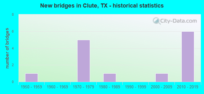
- New bridges - historical statistics
- 11950-1959
- 51970-1979
- 11980-1989
- 12000-2009
- 62010-2019


- Bridge Condition - Deck
- 66.7%Good
- 22.2%Satisfactory
- 11.1%Fair

- Bridge Condition - Superstructure
- 33.3%Very good
- 44.4%Good
- 11.1%Satisfactory
- 11.1%Fair

- Bridge Condition - Substructure
- 33.3%Very good
- 44.4%Good
- 11.1%Satisfactory
- 11.1%Fair

- Bridge Condition - Channel
- 66.7%Good
- 33.3%Satisfactory
Find on map >> Show street view
Structure Number: 120200011108079, Location: 0.95 MI NORTH OF SH 332 (Lat: 29.018114, Lng: -95.393889), Route carried "on" structure: Business State highway 288, Year Built: 2004, Status: Open, Structure Length: 33.83m (110.99ft), Average Daily Traffic: 13,700 (year 2012), Truck Traffic: 3%, Average Future Daily Traffic: 18,760 (year 2030), Design Load: HS 20, Features Intersected: UP RR
Minimum Vertical Clearance: 30+ m (98+ ft), Kilometerpoint: 10.382, Lanes on structure: 4, Owner: State Highway Agency, Approaching Roadway Width: 20.7m (67.9ft), Material/Design: Steel continuous, Design/Construction: Stringer/Multi-beam, Number Of Spans In Main Unit: 3, Number Of Approach Spans: 4, Length of Maximum Span: 91.4m (299.9ft), Curb-To-Curb Width: 20.7m (67.9ft), Out-to-Out Width: 21.6m (70.9ft)
Condition: Deck: Good, Superstructure: Very good, Substructure: Good, Operating Rating: 54.4 metric tons, Method Used To Determine Operating Rating: Assigned rating based on Load Factor Design (LFD) reported in metric tons, Inventory Rating: 32.7 metric tons, Method Used To Determine Inventory Rating: Assigned rating based on Load Factor Design (LFD) reported in metric tons, Structural Evaluation: Better than present minimum criteria, Deck Geometry: Superior to present desirable criteria, Underclear: Superior to present desirable criteria, Approach Roadway Alignment: Equal to present desirable criteria, Designated Inspection Frequency: Every 24 months, Inspection Date: November 2020, Deck Structure Type: Concrete Cast-file-Place
Find on map >> Show street view
Structure Number: 120200152401057, Location: 0.20 MI S OF SH 332 (Lat: 29.001422, Lng: -95.386714), Route carried "on" structure: State highway 288, Year Built: 1970, Status: Open, Structure Length: 15.39m (50.49ft), Average Daily Traffic: 31,923 (year 2020), Truck Traffic: 9%, Average Future Daily Traffic: 17,800 (year 2033), Design Load: HS 20, Features Intersected: SH 288 BUS
Minimum Vertical Clearance: 30+ m (98+ ft), Kilometerpoint: 21.581, Lanes on structure: 2, Lanes under structure: 5, Owner: State Highway Agency, Approaching Roadway Width: 12.2m (40.0ft), Skew: 6 degrees, Material/Design: Prestressed concrete, Design/Construction: Stringer/Multi-beam, Number Of Spans In Main Unit: 5, Length of Maximum Span: 33.5m (109.9ft), Curb-To-Curb Width: 12.3m (40.4ft), Out-to-Out Width: 12.7m (41.7ft)
Condition: Deck: Satisfactory, Superstructure: Good, Substructure: Good, Operating Rating: 54.4 metric tons, Method Used To Determine Operating Rating: Assigned rating based on Load Factor Design (LFD) reported in metric tons, Inventory Rating: 32.7 metric tons, Method Used To Determine Inventory Rating: Assigned rating based on Load Factor Design (LFD) reported in metric tons, Structural Evaluation: Better than present minimum criteria, Deck Geometry: Better than present minimum criteria, Underclear: Equal to present minimum criteria, Approach Roadway Alignment: Equal to present desirable criteria, Designated Inspection Frequency: Every 24 months, Inspection Date: December 2020, Deck Structure Type: Concrete Cast-file-Place
Find on map >> Show street view
Structure Number: 120200152401059, Location: 0.20 MI E OF SH 288 (Lat: 29.005131, Lng: -95.388719), Route carried "on" structure: State highway 332, Year Built: 1972, Status: Open, Structure Length: 10.67m (35.01ft), Average Daily Traffic: 12,500 (year 2013), Truck Traffic: 9%, Average Future Daily Traffic: 24,670 (year 2030), Design Load: HS 20, Features Intersected: SH 288 BUS
Minimum Vertical Clearance: 30+ m (98+ ft), Kilometerpoint: 21.147, Lanes on structure: 3, Lanes under structure: 6, Owner: State Highway Agency, Approaching Roadway Width: 16.5m (54.1ft), Skew: 2 degrees, Material/Design: Prestressed concrete, Design/Construction: Stringer/Multi-beam, Number Of Spans In Main Unit: 4, Length of Maximum Span: 29.0m (95.1ft), Curb-To-Curb Width: 16.5m (54.1ft), Out-to-Out Width: 17.0m (55.8ft)
Condition: Deck: Good, Superstructure: Satisfactory, Substructure: Fair, Operating Rating: 54.4 metric tons, Method Used To Determine Operating Rating: Assigned rating based on Load Factor Design (LFD) reported in metric tons, Inventory Rating: 32.7 metric tons, Method Used To Determine Inventory Rating: Assigned rating based on Load Factor Design (LFD) reported in metric tons, Structural Evaluation: Somewhat better than minimum adequacy, Deck Geometry: Equal to present minimum criteria, Underclear: Better than present minimum criteria, Approach Roadway Alignment: Equal to present desirable criteria, Designated Inspection Frequency: Every 24 months, Inspection Date: November 2020, Deck Structure Type: Concrete Cast-file-Place
Find on map >> Show street view
Structure Number: 120200152401077, Location: 3.4 MI SE of JCT SH 288 (Lat: 29.010150, Lng: -95.419300), Route carried "on" structure: State highway 332, Year Built: 2012, Status: Open, Structure Length: 25.91m (85.01ft), Average Daily Traffic: 27,000 (year 2010), Truck Traffic: 16%, Average Future Daily Traffic: 37,800 (year 2030), Design Load: HL 93, Features Intersected: Dixie Dr.
Minimum Vertical Clearance: 30+ m (98+ ft), Kilometerpoint: 18.443, Lanes on structure: 2, Lanes under structure: 6, Owner: State Highway Agency, Approaching Roadway Width: 12.2m (40.0ft), Material/Design: Prestressed concrete, Design/Construction: Stringer/Multi-beam, Number Of Spans In Main Unit: 8, Length of Maximum Span: 36.9m (121.1ft), Curb-To-Curb Width: 12.2m (40.0ft), Out-to-Out Width: 12.9m (42.3ft)
Condition: Deck: Good, Superstructure: Good, Substructure: Very good, Operating Rating: 54.4 metric tons, Method Used To Determine Operating Rating: Assigned ratings based on Load and Resistance Factor Design (LRFD) reported in metric tons, Inventory Rating: 32.7 metric tons, Method Used To Determine Inventory Rating: Assigned ratings based on Load and Resistance Factor Design (LRFD) reported in metric tons, Structural Evaluation: Better than present minimum criteria, Deck Geometry: Better than present minimum criteria, Underclear: Superior to present desirable criteria, Approach Roadway Alignment: Equal to present desirable criteria, Designated Inspection Frequency: Every 24 months, Inspection Date: December 2020, Deck Structure Type: Concrete Precast Panels
Find on map >> Show street view
Structure Number: 120200152401079, Location: 4.3 MI SE of JCT SH 288 (Lat: 29.009631, Lng: -95.403119), Route carried "on" structure: State highway 332, Year Built: 2012, Status: Open, Structure Length: 26.06m (85.50ft), Average Daily Traffic: 22,120 (year 2010), Truck Traffic: 16%, Average Future Daily Traffic: 30,970 (year 2030), Design Load: HL 93, Features Intersected: Main St.
Minimum Vertical Clearance: 30+ m (98+ ft), Kilometerpoint: 20.049, Lanes on structure: 2, Lanes under structure: 6, Owner: State Highway Agency, Approaching Roadway Width: 12.2m (40.0ft), Material/Design: Prestressed concrete, Design/Construction: Stringer/Multi-beam, Number Of Spans In Main Unit: 8, Length of Maximum Span: 34.4m (112.9ft), Curb-To-Curb Width: 12.2m (40.0ft), Out-to-Out Width: 12.9m (42.3ft)
Condition: Deck: Good, Superstructure: Very good, Substructure: Very good, Operating Rating: 54.4 metric tons, Method Used To Determine Operating Rating: Assigned ratings based on Load and Resistance Factor Design (LRFD) reported in metric tons, Inventory Rating: 32.7 metric tons, Method Used To Determine Inventory Rating: Assigned ratings based on Load and Resistance Factor Design (LRFD) reported in metric tons, Structural Evaluation: Equal to present desirable criteria, Deck Geometry: Better than present minimum criteria, Underclear: Superior to present desirable criteria, Approach Roadway Alignment: Equal to present desirable criteria, Designated Inspection Frequency: Every 24 months, Inspection Date: December 2020, Deck Structure Type: Concrete Precast Panels
Find on map >> Show street view
Structure Number: 12020015240108, Location: 4.3 MI SE of JCT SH 288 (Lat: 29.009831, Lng: -95.405650), Route carried "on" structure: State highway 332, Year Built: 2012, Status: Open, Structure Length: 25.39m (83.30ft), Average Daily Traffic: 22,120 (year 2010), Truck Traffic: 16%, Average Future Daily Traffic: 30,970 (year 2030), Design Load: HL 93, Features Intersected: Main St.
Minimum Vertical Clearance: 30+ m (98+ ft), Kilometerpoint: 20.049, Lanes on structure: 2, Lanes under structure: 6, Owner: State Highway Agency, Approaching Roadway Width: 12.2m (40.0ft), Material/Design: Prestressed concrete, Design/Construction: Stringer/Multi-beam, Number Of Spans In Main Unit: 8, Length of Maximum Span: 36.0m (118.1ft), Curb-To-Curb Width: 12.2m (40.0ft), Out-to-Out Width: 12.9m (42.3ft)
Condition: Deck: Good, Superstructure: Very good, Substructure: Very good, Operating Rating: 54.4 metric tons, Method Used To Determine Operating Rating: Assigned ratings based on Load and Resistance Factor Design (LRFD) reported in metric tons, Inventory Rating: 32.7 metric tons, Method Used To Determine Inventory Rating: Assigned ratings based on Load and Resistance Factor Design (LRFD) reported in metric tons, Structural Evaluation: Equal to present desirable criteria, Deck Geometry: Better than present minimum criteria, Underclear: Superior to present desirable criteria, Approach Roadway Alignment: Equal to present desirable criteria, Designated Inspection Frequency: Every 24 months, Inspection Date: December 2020, Deck Structure Type: Concrete Precast Panels
Find on map >> Show street view
Structure Number: 120200AA1052001, Location: 1.70 MI SW OF FM 523 (Lat: 29.040431, Lng: -95.370250), Route carried "on" structure: County highway 226, Year Built: 1956, Status: Posted for load, Structure Length: 6.49m (21.29ft), Average Daily Traffic: 2,808 (year 2016), Average Future Daily Traffic: 1,650 (year 2032), Features Intersected: OYSTER CRK
Minimum Vertical Clearance: 30+ m (98+ ft), Kilometerpoint: 3.701, Lanes on structure: 2, Owner: County Highway Agency, Approaching Roadway Width: 6.1m (20.0ft), Material/Design: Concrete, Design/Construction: Stringer/Multi-beam, Number Of Spans In Main Unit: 7, Length of Maximum Span: 9.1m (29.9ft), Curb-To-Curb Width: 7.3m (24.0ft), Out-to-Out Width: 7.9m (25.9ft)
Condition: Deck: Fair, Superstructure: Fair, Substructure: Satisfactory, Channel: Good, Operating Rating: 32.7 metric tons, Method Used To Determine Operating Rating: Field evaluation and documented engineering judgment, Inventory Rating: 24.5 metric tons, Method Used To Determine Inventory Rating: Field evaluation and documented engineering judgment, Structural Evaluation: Somewhat better than minimum adequacy, Deck Geometry: High priority of replacement, Waterway Adequacy: Better than present minimum criteria, Approach Roadway Alignment: Equal to present desirable criteria, Length Of Structure Improvement: 6.49m (21.29ft), Designated Inspection Frequency: Every 24 months, Inspection Date: November 2021, Bridge Improvement Cost: $101,000, Roadway Improvement Cost: $25,000, Total Project Cost: $126,000, Deck Structure Type: Concrete Cast-file-Place, Wearing Surface/Protective System: Wearing Surface: Bituminous
Find on map >> Show street view
Structure Number: 120200AA1056001, Location: 0.05 MI N OF KYLE RD (Lat: 29.040458, Lng: -95.391833), Route carried "on" structure: County highway 228, Year Built: 1989, Status: Open, Structure Length: 6.37m (20.90ft), Average Daily Traffic: 260 (year 2012), Truck Traffic: 1%, Average Future Daily Traffic: 40 (year 2032), Design Load: HS 20, Features Intersected: OYSTER CREEK
Minimum Vertical Clearance: 30+ m (98+ ft), Kilometerpoint: 0.097, Lanes on structure: 2, Owner: County Highway Agency, Approaching Roadway Width: 6.1m (20.0ft), Skew: 2 degrees, Material/Design: Concrete, Design/Construction: Stringer/Multi-beam, Number Of Spans In Main Unit: 5, Length of Maximum Span: 12.8m (42.0ft), Curb-To-Curb Width: 7.3m (24.0ft), Out-to-Out Width: 8.1m (26.6ft)
Condition: Deck: Good, Superstructure: Good, Substructure: Good, Channel: Good, Operating Rating: 48.1 metric tons, Method Used To Determine Operating Rating: Load Factor (LF), Inventory Rating: 29.0 metric tons, Method Used To Determine Inventory Rating: Load Factor (LF), Structural Evaluation: Better than present minimum criteria, Deck Geometry: Somewhat better than minimum adequacy, Waterway Adequacy: Better than present minimum criteria, Approach Roadway Alignment: Equal to present desirable criteria, Designated Inspection Frequency: Every 24 months, Inspection Date: December 2021, Deck Structure Type: Concrete Cast-file-Place
Find on map >> Show street view
Structure Number: 120200N00007001, Location: 0.15 MI W OF BUS 288 (Lat: 29.045514, Lng: -95.404725), Route carried "on" structure: City street , Year Built: 1970, Status: Open, Structure Length: 5.55m (18.21ft), Average Daily Traffic: 3,300 (year 2012), Truck Traffic: 5%, Average Future Daily Traffic: 4,000 (year 2032), Features Intersected: OYSTER CREEK, Facility Carried by Structure: COLLEGE BLVD WB
Minimum Vertical Clearance: 30+ m (98+ ft), Kilometerpoint: 0.998, Lanes on structure: 2, Owner: Town or Township Highway Agency, Approaching Roadway Width: 7.3m (24.0ft), Skew: 1 degrees, Material/Design: Prestressed concrete, Design/Construction: Stringer/Multi-beam, Number Of Spans In Main Unit: 3, Length of Maximum Span: 18.3m (60.0ft), Curb or Sidewalk Widths: Left: 0.6m (2.0ft), Right: 0.0m, Curb-To-Curb Width: 9.8m (32.2ft), Out-to-Out Width: 11.4m (37.4ft)
Condition: Deck: Satisfactory, Superstructure: Good, Substructure: Good, Channel: Satisfactory, Operating Rating: 32.7 metric tons, Method Used To Determine Operating Rating: Field evaluation and documented engineering judgment, Inventory Rating: 24.5 metric tons, Method Used To Determine Inventory Rating: Field evaluation and documented engineering judgment, Structural Evaluation: Equal to present minimum criteria, Deck Geometry: Meets minimum limits, Waterway Adequacy: Equal to present minimum criteria, Approach Roadway Alignment: Equal to present desirable criteria, Length Of Structure Improvement: 5.55m (18.21ft), Designated Inspection Frequency: Every 24 months, Inspection Date: December 2021, Bridge Improvement Cost: $10,000, Roadway Improvement Cost: $3,000, Total Project Cost: $13,000, Deck Structure Type: Concrete Cast-file-Place, Wearing Surface/Protective System: Wearing Surface: Bituminous
Find on map >> Show street view
Structure Number: 120200152401057, Location: 0.20 MI S OF SH 332 (Lat: 29.001914, Lng: -95.387494), Route carried "under" structure: Business State highway 288, Year Built: 1970, Structure Length: 0. m, Average Daily Traffic: 11,060 (year 2015), Truck Traffic: 15%, Features Intersected: SH 288 BUS
Minimum Vertical Clearance: 5.49m (18.01ft), Kilometerpoint: 0.000, Lanes on structure: 2, Lanes under structure: 5, Material/Design: Prestressed concrete, Design/Construction: Stringer/Multi-beam, Length of Maximum Span: 33.5m (109.9ft)
Find on map >> Show street view
Structure Number: 120200152401059, Location: 0.20 MI E OF SH 288 (Lat: 29.005131, Lng: -95.388719), Route carried "under" structure: State highway 288, Year Built: 1972, Structure Length: 0. m, Average Daily Traffic: 16,310 (year 2013), Truck Traffic: 15%, Features Intersected: SH 288 BUS, Facility Carried by Structure: SH 332 WB
Minimum Vertical Clearance: 5.79m (19.00ft), Kilometerpoint: 11.027, Lanes on structure: 3, Lanes under structure: 6, Material/Design: Prestressed concrete, Design/Construction: Stringer/Multi-beam, Length of Maximum Span: 29.0m (95.1ft)
Find on map >> Show street view
Structure Number: 120200152401077, Location: 3.4 MI SE of JCT SH 288 (Lat: 29.010150, Lng: -95.419300), Route carried "under" structure: City street 2, Year Built: 2012, Structure Length: 0. m, Average Daily Traffic: 50 (year 2015), Truck Traffic: 1%, Features Intersected: Dixie Dr.
Minimum Vertical Clearance: 5.26m (17.26ft), Kilometerpoint: 18.585, Lanes on structure: 2, Lanes under structure: 6, Material/Design: Prestressed concrete, Design/Construction: Stringer/Multi-beam, Length of Maximum Span: 36.9m (121.1ft)
Find on map >> Show street view
Structure Number: 120200152401079, Location: 4.3 MI SE of JCT SH 288 (Lat: 29.009631, Lng: -95.403119), Route carried "under" structure: City street 2, Year Built: 2012, Structure Length: 0. m, Average Daily Traffic: 50 (year 2015), Truck Traffic: 1%, Features Intersected: Main St.
Minimum Vertical Clearance: 5.36m (17.59ft), Kilometerpoint: 20.152, Lanes on structure: 2, Lanes under structure: 6, Material/Design: Prestressed concrete, Design/Construction: Stringer/Multi-beam, Length of Maximum Span: 34.4m (112.9ft)
Find on map >> Show street view
Structure Number: 12020015240108, Location: 4.3 MI SE of JCT SH 288 (Lat: 29.009831, Lng: -95.405650), Route carried "under" structure: City street 2, Year Built: 2012, Structure Length: 0. m, Average Daily Traffic: 50 (year 2015), Truck Traffic: 1%, Features Intersected: Main St.
Minimum Vertical Clearance: 5.36m (17.59ft), Kilometerpoint: 20.152, Lanes on structure: 2, Lanes under structure: 6, Material/Design: Prestressed concrete, Design/Construction: Stringer/Multi-beam, Length of Maximum Span: 36.0m (118.1ft)