Bridge Statistics for Coldwater, Michigan (MI)
Condition, Traffic, Stress, Structural Evaluation, Project Costs
- National Bridge Inventory (NBI) Statistics
- 36Number of bridges
- 272ft / 82.7mTotal length
- $768,000Total costs
- 352,244Total average daily traffic
- 91,942Total average daily truck traffic
- National Bridge Inventory (NBI) Registered Bridges for Coldwater
- No street view available for this location
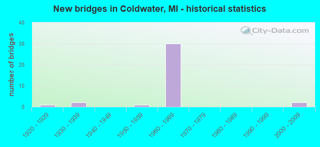
- New bridges - historical statistics
- 11920-1929
- 21930-1939
- 11950-1959
- 301960-1969
- 22000-2009


- Bridge Condition - Deck
- 26.3%Good
- 68.4%Satisfactory
- 5.3%Poor

- Bridge Condition - Superstructure
- 5.3%Very good
- 36.8%Good
- 21.1%Satisfactory
- 36.8%Fair

- Bridge Condition - Substructure
- 52.6%Good
- 31.6%Satisfactory
- 5.3%Fair
- 5.3%Poor
- 5.3%Critical

- Bridge Condition - Channel
- 14.3%Good
- 42.9%Satisfactory
- 35.7%Fair
- 7.1%Poor

- Bridge Condition - Culverts
- 60.0%Fair
- 40.0%Poor
Find on map >> Show street view
Structure Number: 1066, Location: W LTS OF COLDWATER (Lat: 41.944703, Lng: -85.030914), Route carried "on" structure: US 12, Year Built: 1939, Year Reconstructed: 1997, Status: Open, Structure Length: 2.34m (7.68ft), Average Daily Traffic: 14,651 (year 2007), Truck Traffic: 4%, Average Future Daily Traffic: 17,810 (year 2018), Design Load: HS 25 or greater, Features Intersected: COLDWATER RIVER
Minimum Vertical Clearance: 30.48m (100.00ft), Kilometerpoint: 26.203, Lanes on structure: 3, Owner: State Highway Agency, Approaching Roadway Width: 12.2m (40.0ft), Skew: 2 degrees, Material/Design: Prestressed concrete, Design/Construction: Stringer/Multi-beam, Number Of Spans In Main Unit: 1, Length of Maximum Span: 23.4m (76.8ft), Curb or Sidewalk Widths: Left: 0.0m, Right: 1.5m (4.9ft), Curb-To-Curb Width: 15.3m (50.2ft), Out-to-Out Width: 17.8m (58.4ft)
Condition: Deck: Good, Superstructure: Good, Substructure: Satisfactory, Channel: Satisfactory, Operating Rating: 85.5 metric tons, Method Used To Determine Operating Rating: Load Factor (LF) rating reported by rating factor (RF) method using MS18 loading, Inventory Rating: 45.7 metric tons, Method Used To Determine Inventory Rating: Load Factor (LF) rating reported by rating factor (RF) method using MS18 loading, Structural Evaluation: Equal to present minimum criteria, Deck Geometry: Equal to present minimum criteria, Waterway Adequacy: Equal to present desirable criteria, Approach Roadway Alignment: Equal to present minimum criteria, Designated Inspection Frequency: Every 24 months, Inspection Date: May 2021, Deck Structure Type: Concrete Cast-file-Place, Wearing Surface/Protective System: Wearing Surface: Epoxy Overlay, Deck Protection: Epoxy Coated Reinforcing
Find on map >> Show street view
Structure Number: 1072, Location: IN COLDWATER (Lat: 41.932344, Lng: -85.004747), Route carried "on" structure: Business Interstate 69, Year Built: 1929, Year Reconstructed: 2002, Status: Open, Structure Length: 0.88m (2.89ft), Average Daily Traffic: 6,063 (year 2007), Truck Traffic: 2%, Average Future Daily Traffic: 11,016 (year 2018), Design Load: HS 25 or greater, Features Intersected: SAUK RIVER
Minimum Vertical Clearance: 30.48m (100.00ft), Kilometerpoint: 5.012, Lanes on structure: 4, Base Highway Network: Yes (Inventory Route: 92, Subroute: 2), Owner: State Highway Agency, Approaching Roadway Width: 14.0m (45.9ft), Material/Design: Prestressed concrete, Design/Construction: Box Beam or Girders - Single/Spread, Number Of Spans In Main Unit: 1, Length of Maximum Span: 8.8m (28.9ft), Curb or Sidewalk Widths: Left: 1.4m (4.6ft), Right: 1.4m (4.6ft), Curb-To-Curb Width: 14.0m (45.9ft), Out-to-Out Width: 17.4m (57.1ft)
Condition: Deck: Good, Superstructure: Very good, Substructure: Good, Channel: Satisfactory, Operating Rating: 67.4 metric tons, Method Used To Determine Operating Rating: Load Factor (LF) rating reported by rating factor (RF) method using MS18 loading, Inventory Rating: 40.8 metric tons, Method Used To Determine Inventory Rating: Load Factor (LF) rating reported by rating factor (RF) method using MS18 loading, Structural Evaluation: Better than present minimum criteria, Deck Geometry: High priority of replacement, Waterway Adequacy: Better than present minimum criteria, Approach Roadway Alignment: Equal to present minimum criteria, Designated Inspection Frequency: Every 24 months, Inspection Date: May 2021, Deck Structure Type: Concrete Cast-file-Place, Wearing Surface/Protective System: Wearing Surface: Epoxy Overlay, Deck Protection: Epoxy Coated Reinforcing
Find on map >> Show street view
Structure Number: 1074, Location: 0.8 MI S OF US-12 (Lat: 41.924358, Lng: -84.973233), Route carried "on" structure: Interstate 69, Year Built: 1967, Status: Open, Structure Length: 1.46m (4.79ft), Average Daily Traffic: 17,675 (year 2013), Truck Traffic: 31%, Average Future Daily Traffic: 19,252 (year 2033), Design Load: HS 20+Mod, Features Intersected: SAUK RIVER
Minimum Vertical Clearance: 30.48m (100.00ft), Kilometerpoint: 18.976, Lanes on structure: 2, Base Highway Network: Yes (Inventory Route: 92, Subroute: 4), Owner: State Highway Agency, Approaching Roadway Width: 12.3m (40.4ft), Skew: 2 degrees, Material/Design: Steel, Design/Construction: Stringer/Multi-beam, Number Of Spans In Main Unit: 1, Length of Maximum Span: 14.6m (47.9ft), Curb-To-Curb Width: 11.8m (38.7ft), Out-to-Out Width: 12.9m (42.3ft)
Condition: Deck: Satisfactory, Superstructure: Good, Substructure: Good, Channel: Satisfactory, Operating Rating: 58.6 metric tons, Method Used To Determine Operating Rating: Load Factor (LF) rating reported by rating factor (RF) method using MS18 loading, Inventory Rating: 35.0 metric tons, Method Used To Determine Inventory Rating: Load Factor (LF) rating reported by rating factor (RF) method using MS18 loading, Structural Evaluation: Better than present minimum criteria, Deck Geometry: Equal to present minimum criteria, Waterway Adequacy: Equal to present desirable criteria, Approach Roadway Alignment: Equal to present desirable criteria, Designated Inspection Frequency: Every 24 months, Inspection Date: May 2021, Deck Structure Type: Concrete Cast-file-Place, Wearing Surface/Protective System: Wearing Surface: Latex Concrete
Find on map >> Show street view
Structure Number: 1076, Location: 0.8 MI S OF US-12 (Lat: 41.924433, Lng: -84.972675), Route carried "on" structure: Interstate 69, Year Built: 1967, Status: Open, Structure Length: 1.43m (4.69ft), Average Daily Traffic: 17,675 (year 2013), Truck Traffic: 31%, Average Future Daily Traffic: 19,525 (year 2033), Design Load: HS 20+Mod, Features Intersected: SAUK RIVER
Minimum Vertical Clearance: 30.48m (100.00ft), Kilometerpoint: 18.993, Lanes on structure: 2, Base Highway Network: Yes (Inventory Route: 92, Subroute: 7), Owner: State Highway Agency, Approaching Roadway Width: 11.6m (38.1ft), Skew: 1 degrees, Material/Design: Steel, Design/Construction: Stringer/Multi-beam, Number Of Spans In Main Unit: 1, Length of Maximum Span: 14.3m (46.9ft), Curb-To-Curb Width: 11.8m (38.7ft), Out-to-Out Width: 12.9m (42.3ft)
Condition: Deck: Satisfactory, Superstructure: Good, Substructure: Good, Channel: Satisfactory, Operating Rating: 58.6 metric tons, Method Used To Determine Operating Rating: Load Factor (LF) rating reported by rating factor (RF) method using MS18 loading, Inventory Rating: 35.0 metric tons, Method Used To Determine Inventory Rating: Load Factor (LF) rating reported by rating factor (RF) method using MS18 loading, Structural Evaluation: Better than present minimum criteria, Deck Geometry: Equal to present minimum criteria, Waterway Adequacy: Equal to present desirable criteria, Approach Roadway Alignment: Equal to present desirable criteria, Designated Inspection Frequency: Every 24 months, Inspection Date: May 2021, Deck Structure Type: Concrete Cast-file-Place, Wearing Surface/Protective System: Wearing Surface: Latex Concrete
Find on map >> Show street view
Structure Number: 1077, Location: 0.2 MI S OF US-12 (Lat: 41.932858, Lng: -84.973283), Route carried "on" structure: Interstate 69, Year Built: 1967, Status: Open, Structure Length: 6.00m (19.69ft), Average Daily Traffic: 10,583 (year 2007), Truck Traffic: 35%, Average Future Daily Traffic: 14,745 (year 2018), Design Load: HS 20+Mod, Features Intersected: INDIANA NE RR, SAUK R RD
Minimum Vertical Clearance: 30.48m (100.00ft), Kilometerpoint: 19.960, Lanes on structure: 3, Lanes under structure: 2, Base Highway Network: Yes (Inventory Route: 92, Subroute: 4), Owner: State Highway Agency, Approaching Roadway Width: 12.5m (41.0ft), Material/Design: Steel, Design/Construction: Stringer/Multi-beam, Number Of Spans In Main Unit: 3, Length of Maximum Span: 28.3m (92.8ft), Curb-To-Curb Width: 13.6m (44.6ft), Out-to-Out Width: 14.5m (47.6ft)
Condition: Deck: Satisfactory, Superstructure: Fair, Substructure: Satisfactory, Operating Rating: 75.0 metric tons, Method Used To Determine Operating Rating: Load Factor (LF), Inventory Rating: 44.9 metric tons, Method Used To Determine Inventory Rating: Load Factor (LF), Structural Evaluation: Somewhat better than minimum adequacy, Deck Geometry: High priority of corrective action, Underclear: Superior to present desirable criteria, Approach Roadway Alignment: Equal to present desirable criteria, Length Of Structure Improvement: 6.01m (19.72ft), Designated Inspection Frequency: Every 24 months, Inspection Date: May 2021, Bridge Improvement Cost: $986,000, Roadway Improvement Cost: $17,000, Total Project Cost: $202,000, Deck Structure Type: Concrete Cast-file-Place, Wearing Surface/Protective System: Wearing Surface: Latex Concrete
Find on map >> Show street view
Structure Number: 1078, Location: 0.2 MI S OF US-12 (Lat: 41.932819, Lng: -84.972822), Route carried "on" structure: Interstate 69, Year Built: 1967, Status: Open, Structure Length: 6.00m (19.69ft), Average Daily Traffic: 10,583 (year 2007), Truck Traffic: 35%, Average Future Daily Traffic: 14,745 (year 2018), Design Load: HS 20+Mod, Features Intersected: INDIANA NE RR, SAUK R RD
Minimum Vertical Clearance: 30.48m (100.00ft), Kilometerpoint: 19.963, Lanes on structure: 2, Lanes under structure: 2, Base Highway Network: Yes (Inventory Route: 92, Subroute: 7), Owner: State Highway Agency, Approaching Roadway Width: 12.5m (41.0ft), Material/Design: Steel, Design/Construction: Stringer/Multi-beam, Number Of Spans In Main Unit: 3, Length of Maximum Span: 28.3m (92.8ft), Curb-To-Curb Width: 11.9m (39.0ft), Out-to-Out Width: 12.8m (42.0ft)
Condition: Deck: Satisfactory, Superstructure: Fair, Substructure: Satisfactory, Operating Rating: 73.9 metric tons, Method Used To Determine Operating Rating: Load Factor (LF), Inventory Rating: 44.2 metric tons, Method Used To Determine Inventory Rating: Load Factor (LF), Structural Evaluation: Somewhat better than minimum adequacy, Deck Geometry: Equal to present minimum criteria, Underclear: Superior to present desirable criteria, Approach Roadway Alignment: Equal to present desirable criteria, Length Of Structure Improvement: 6.01m (19.72ft), Designated Inspection Frequency: Every 24 months, Inspection Date: May 2021, Bridge Improvement Cost: $307,000, Roadway Improvement Cost: $6,000, Total Project Cost: $75,000, Deck Structure Type: Concrete Cast-file-Place, Wearing Surface/Protective System: Wearing Surface: Latex Concrete
Find on map >> Show street view
Structure Number: 1082, Location: 2.9 MI S OF US-12 (Lat: 41.898192, Lng: -84.990561), Route carried "on" structure: Business Interstate 69, Year Built: 1967, Status: Open, Structure Length: 6.58m (21.59ft), Average Daily Traffic: 2,300 (year 2008), Truck Traffic: 12%, Average Future Daily Traffic: 2,645 (year 2028), Design Load: HS 20, Features Intersected: I-69
Minimum Vertical Clearance: 30.48m (100.00ft), Kilometerpoint: 0.222, Lanes on structure: 2, Lanes under structure: 4, Base Highway Network: Yes (Inventory Route: 92, Subroute: 2), Owner: State Highway Agency, Approaching Roadway Width: 13.1m (43.0ft), Material/Design: Steel continuous, Design/Construction: Stringer/Multi-beam, Number Of Spans In Main Unit: 2, Length of Maximum Span: 32.9m (107.9ft), Curb-To-Curb Width: 9.9m (32.5ft), Out-to-Out Width: 11.0m (36.1ft)
Condition: Deck: Satisfactory, Superstructure: Good, Substructure: Good, Operating Rating: 64.2 metric tons, Method Used To Determine Operating Rating: Load Factor (LF) rating reported by rating factor (RF) method using MS18 loading, Inventory Rating: 38.6 metric tons, Method Used To Determine Inventory Rating: Load Factor (LF) rating reported by rating factor (RF) method using MS18 loading, Structural Evaluation: Better than present minimum criteria, Deck Geometry: Meets minimum limits, Underclear: Meets minimum limits, Approach Roadway Alignment: Equal to present desirable criteria, Length Of Structure Improvement: 6.59m (21.62ft), Designated Inspection Frequency: Every 24 months, Inspection Date: November 2021, Bridge Improvement Cost: $89,000, Roadway Improvement Cost: $8,000, Total Project Cost: $90,000, Deck Structure Type: Concrete Cast-file-Place, Wearing Surface/Protective System: Wearing Surface: Latex Concrete, Deck Protection: Epoxy Coated Reinforcing
Find on map >> Show street view
Structure Number: 1084, Location: IN COLDWATER (Lat: 41.936192, Lng: -84.973347), Route carried "on" structure: Interstate 69, Year Built: 1967, Status: Open, Structure Length: 4.55m (14.93ft), Average Daily Traffic: 10,583 (year 2007), Truck Traffic: 35%, Average Future Daily Traffic: 14,258 (year 2018), Design Load: HS 20+Mod, Features Intersected: US-12
Minimum Vertical Clearance: 30+ m (98+ ft), Kilometerpoint: 20.291, Lanes on structure: 2, Lanes under structure: 5, Base Highway Network: Yes (Inventory Route: 92, Subroute: 4), Owner: State Highway Agency, Approaching Roadway Width: 11.5m (37.7ft), Skew: 1 degrees, Material/Design: Steel, Design/Construction: Stringer/Multi-beam, Number Of Spans In Main Unit: 3, Length of Maximum Span: 23.0m (75.5ft), Curb-To-Curb Width: 11.9m (39.0ft), Out-to-Out Width: 12.9m (42.3ft)
Condition: Deck: Satisfactory, Superstructure: Fair, Substructure: Good, Operating Rating: 68.4 metric tons, Method Used To Determine Operating Rating: Load Factor (LF) rating reported by rating factor (RF) method using MS18 loading, Inventory Rating: 41.1 metric tons, Method Used To Determine Inventory Rating: Load Factor (LF) rating reported by rating factor (RF) method using MS18 loading, Structural Evaluation: Somewhat better than minimum adequacy, Deck Geometry: Equal to present minimum criteria, Underclear: Somewhat better than minimum adequacy, Approach Roadway Alignment: Equal to present desirable criteria, Designated Inspection Frequency: Every 24 months, Inspection Date: May 2021, Bridge Improvement Cost: $206,000, Deck Structure Type: Concrete Cast-file-Place, Wearing Surface/Protective System: Wearing Surface: Latex Concrete
Find on map >> Show street view
Structure Number: 1087, Location: IN COLDWATER (Lat: 41.936103, Lng: -84.972775), Route carried "on" structure: Interstate 69, Year Built: 2002, Status: Open, Structure Length: 4.79m (15.72ft), Average Daily Traffic: 10,583 (year 2007), Truck Traffic: 35%, Average Future Daily Traffic: 14,258 (year 2018), Design Load: HS 25 or greater, Features Intersected: US-12
Minimum Vertical Clearance: 30+ m (98+ ft), Kilometerpoint: 20.290, Lanes on structure: 3, Lanes under structure: 5, Base Highway Network: Yes (Inventory Route: 92, Subroute: 7), Owner: State Highway Agency, Approaching Roadway Width: 12.2m (40.0ft), Skew: 1 degrees, Material/Design: Prestressed concrete, Design/Construction: Box Beam or Girders - Single/Spread, Number Of Spans In Main Unit: 3, Length of Maximum Span: 28.5m (93.5ft), Curb-To-Curb Width: 16.9m (55.4ft), Out-to-Out Width: 17.8m (58.4ft)
Condition: Deck: Good, Superstructure: Satisfactory, Substructure: Good, Operating Rating: 60.6 metric tons, Method Used To Determine Operating Rating: Load Factor (LF) rating reported by rating factor (RF) method using MS18 loading, Inventory Rating: 36.3 metric tons, Method Used To Determine Inventory Rating: Load Factor (LF) rating reported by rating factor (RF) method using MS18 loading, Structural Evaluation: Equal to present minimum criteria, Deck Geometry: Equal to present minimum criteria, Underclear: Somewhat better than minimum adequacy, Approach Roadway Alignment: Equal to present desirable criteria, Designated Inspection Frequency: Every 24 months, Inspection Date: May 2021, Deck Structure Type: Concrete Cast-file-Place, Wearing Surface/Protective System: Wearing Surface: Epoxy Overlay, Deck Protection: Epoxy Coated Reinforcing
Find on map >> Show street view
Structure Number: 109, Location: 6.7 MI N OF US-12 (Lat: 42.033167, Lng: -84.977317), Route carried "on" structure: Interstate 69, Year Built: 1967, Status: Open, Structure Length: 2.92m (9.58ft), Average Daily Traffic: 10,926 (year 2007), Truck Traffic: 36%, Average Future Daily Traffic: 13,711 (year 2018), Design Load: HS 20+Mod, Features Intersected: HOG CREEK
Minimum Vertical Clearance: 30.48m (100.00ft), Kilometerpoint: 31.113, Lanes on structure: 2, Base Highway Network: Yes (Inventory Route: 92, Subroute: 4), Owner: State Highway Agency, Approaching Roadway Width: 11.6m (38.1ft), Material/Design: Prestressed concrete, Design/Construction: Stringer/Multi-beam, Number Of Spans In Main Unit: 2, Length of Maximum Span: 14.6m (47.9ft), Curb-To-Curb Width: 11.8m (38.7ft), Out-to-Out Width: 12.9m (42.3ft)
Condition: Deck: Good, Superstructure: Fair, Substructure: Fair, Channel: Satisfactory, Operating Rating: 68.7 metric tons, Method Used To Determine Operating Rating: Load Factor (LF) rating reported by rating factor (RF) method using MS18 loading, Inventory Rating: 41.1 metric tons, Method Used To Determine Inventory Rating: Load Factor (LF) rating reported by rating factor (RF) method using MS18 loading, Structural Evaluation: Somewhat better than minimum adequacy, Deck Geometry: Equal to present minimum criteria, Waterway Adequacy: Equal to present desirable criteria, Approach Roadway Alignment: Equal to present desirable criteria, Designated Inspection Frequency: Every 24 months, Inspection Date: May 2021, Deck Structure Type: Concrete Cast-file-Place, Wearing Surface/Protective System: Wearing Surface: Latex Concrete
Find on map >> Show street view
Structure Number: 1092, Location: 3.0 MI N OF US-12 (Lat: 41.980044, Lng: -84.971675), Route carried "on" structure: Interstate 69, Year Built: 1967, Status: Open, Structure Length: 0.84m (2.76ft), Average Daily Traffic: 20,204 (year 2007), Truck Traffic: 35%, Average Future Daily Traffic: 28,516 (year 2018), Design Load: HS 20+Mod, Features Intersected: COLD CREEK
Minimum Vertical Clearance: 30.48m (100.00ft), Kilometerpoint: 25.176, Lanes on structure: 6, Base Highway Network: Yes (Inventory Route: 92, Subroute: 7), Owner: State Highway Agency, Approaching Roadway Width: 24.4m (80.1ft), Skew: 4 degrees, Material/Design: Concrete, Design/Construction: Culvert, Number Of Spans In Main Unit: 2, Length of Maximum Span: 3.6m (11.8ft)
Condition: Channel: Fair, Culverts: Fair, Operating Rating: 97.2 metric tons, Method Used To Determine Operating Rating: Load Factor (LF) rating reported by rating factor (RF) method using MS18 loading, Inventory Rating: 97.2 metric tons, Method Used To Determine Inventory Rating: Load Factor (LF) rating reported by rating factor (RF) method using MS18 loading, Structural Evaluation: Somewhat better than minimum adequacy, Waterway Adequacy: Equal to present minimum criteria, Approach Roadway Alignment: Equal to present minimum criteria, Designated Inspection Frequency: Every 24 months, Inspection Date: March 2021, Wearing Surface/Protective System: Wearing Surface: Monolithic Concrete
Find on map >> Show street view
Structure Number: 1094, Location: 1.4 MI N OF US-12 (Lat: 41.956208, Lng: -84.973250), Route carried "on" structure: County highway 1268, Year Built: 1967, Status: Open, Structure Length: 6.58m (21.59ft), Average Daily Traffic: 1,035 (year 2008), Truck Traffic: 15%, Average Future Daily Traffic: 1,190 (year 2028), Design Load: H 15, Features Intersected: I-69, Facility Carried by Structure: STATE ROAD
Minimum Vertical Clearance: 30.48m (100.00ft), Kilometerpoint: 3.426, Lanes on structure: 2, Lanes under structure: 4, Owner: State Highway Agency, Approaching Roadway Width: 7.6m (24.9ft), Material/Design: Steel continuous, Design/Construction: Stringer/Multi-beam, Number Of Spans In Main Unit: 2, Length of Maximum Span: 32.9m (107.9ft), Curb or Sidewalk Widths: Left: 0.2m (0.7ft), Right: 0.2m (0.7ft), Curb-To-Curb Width: 7.9m (25.9ft), Out-to-Out Width: 9.9m (32.5ft)
Condition: Deck: Satisfactory, Superstructure: Good, Substructure: Good, Operating Rating: 66.7 metric tons, Method Used To Determine Operating Rating: Load Factor (LF) rating reported by rating factor (RF) method using MS18 loading, Inventory Rating: 39.9 metric tons, Method Used To Determine Inventory Rating: Load Factor (LF) rating reported by rating factor (RF) method using MS18 loading, Structural Evaluation: Better than present minimum criteria, Deck Geometry: Meets minimum limits, Underclear: Meets minimum limits, Approach Roadway Alignment: Equal to present minimum criteria, Length Of Structure Improvement: 6.59m (21.62ft), Designated Inspection Frequency: Every 24 months, Inspection Date: November 2021, Bridge Improvement Cost: $75,000, Roadway Improvement Cost: $6,000, Total Project Cost: $72,000, Deck Structure Type: Concrete Cast-file-Place, Wearing Surface/Protective System: Wearing Surface: Latex Concrete, Deck Protection: Epoxy Coated Reinforcing
Find on map >> Show street view
Structure Number: 1095, Location: 2.4 MI N OF US-12 (Lat: 41.970814, Lng: -84.972808), Route carried "on" structure: County highway , Year Built: 1967, Status: Open, Structure Length: 6.58m (21.59ft), Average Daily Traffic: 345 (year 2008), Truck Traffic: 15%, Average Future Daily Traffic: 397 (year 2028), Design Load: H 15, Features Intersected: I-69, Facility Carried by Structure: NEWTON ROAD
Minimum Vertical Clearance: 30.48m (100.00ft), Kilometerpoint: 2.313, Lanes on structure: 2, Lanes under structure: 4, Owner: State Highway Agency, Approaching Roadway Width: 6.8m (22.3ft), Material/Design: Steel continuous, Design/Construction: Stringer/Multi-beam, Number Of Spans In Main Unit: 2, Length of Maximum Span: 32.9m (107.9ft), Curb or Sidewalk Widths: Left: 0.1m (0.3ft), Right: 0.1m (0.3ft), Curb-To-Curb Width: 7.9m (25.9ft), Out-to-Out Width: 9.9m (32.5ft)
Condition: Deck: Satisfactory, Superstructure: Good, Substructure: Good, Operating Rating: 64.5 metric tons, Method Used To Determine Operating Rating: Load Factor (LF) rating reported by rating factor (RF) method using MS18 loading, Inventory Rating: 38.6 metric tons, Method Used To Determine Inventory Rating: Load Factor (LF) rating reported by rating factor (RF) method using MS18 loading, Structural Evaluation: Better than present minimum criteria, Deck Geometry: Somewhat better than minimum adequacy, Underclear: Meets minimum limits, Approach Roadway Alignment: Equal to present desirable criteria, Length Of Structure Improvement: 6.59m (21.62ft), Designated Inspection Frequency: Every 24 months, Inspection Date: November 2021, Bridge Improvement Cost: $25,000, Roadway Improvement Cost: $7,000, Total Project Cost: $86,000, Deck Structure Type: Concrete Cast-file-Place, Wearing Surface/Protective System: Wearing Surface: Latex Concrete, Deck Protection: Epoxy Coated Reinforcing
Find on map >> Show street view
Structure Number: 1096, Location: 3.4 MI N OF US-12 (Lat: 41.985572, Lng: -84.971700), Route carried "on" structure: County highway 1274, Year Built: 1967, Status: Open, Structure Length: 6.58m (21.59ft), Average Daily Traffic: 900 (year 1988), Average Future Daily Traffic: 1,035 (year 2008), Design Load: H 20, Features Intersected: I-69, Facility Carried by Structure: JONESVILLE ROAD
Minimum Vertical Clearance: 30.48m (100.00ft), Kilometerpoint: 4.022, Lanes on structure: 2, Lanes under structure: 4, Owner: State Highway Agency, Approaching Roadway Width: 7.1m (23.3ft), Material/Design: Steel continuous, Design/Construction: Stringer/Multi-beam, Number Of Spans In Main Unit: 2, Length of Maximum Span: 32.9m (107.9ft), Curb or Sidewalk Widths: Left: 0.2m (0.7ft), Right: 0.2m (0.7ft), Curb-To-Curb Width: 9.2m (30.2ft), Out-to-Out Width: 11.1m (36.4ft)
Condition: Deck: Satisfactory, Superstructure: Good, Substructure: Good, Operating Rating: 63.5 metric tons, Method Used To Determine Operating Rating: Load Factor (LF) rating reported by rating factor (RF) method using MS18 loading, Inventory Rating: 37.9 metric tons, Method Used To Determine Inventory Rating: Load Factor (LF) rating reported by rating factor (RF) method using MS18 loading, Structural Evaluation: Better than present minimum criteria, Deck Geometry: Equal to present minimum criteria, Underclear: Meets minimum limits, Approach Roadway Alignment: Equal to present desirable criteria, Designated Inspection Frequency: Every 24 months, Inspection Date: May 2021, Deck Structure Type: Concrete Cast-file-Place, Wearing Surface/Protective System: Wearing Surface: Other
Find on map >> Show street view
Structure Number: 1097, Location: 5.5 MI N OF US-12 (Lat: 42.014719, Lng: -84.972842), Route carried "on" structure: County highway , Year Built: 1967, Status: Open, Structure Length: 7.59m (24.90ft), Average Daily Traffic: 60 (year 1988), Average Future Daily Traffic: 69 (year 2008), Design Load: H 15, Features Intersected: I-69, Facility Carried by Structure: DAYBURG ROAD
Minimum Vertical Clearance: 30.48m (100.00ft), Kilometerpoint: 4.106, Lanes on structure: 2, Lanes under structure: 4, Owner: State Highway Agency, Approaching Roadway Width: 6.6m (21.7ft), Skew: 1 degrees, Material/Design: Steel, Design/Construction: Stringer/Multi-beam, Number Of Spans In Main Unit: 4, Length of Maximum Span: 26.8m (87.9ft), Curb-To-Curb Width: 8.0m (26.2ft), Out-to-Out Width: 9.5m (31.2ft)
Condition: Deck: Satisfactory, Superstructure: Fair, Substructure: Satisfactory, Operating Rating: 76.2 metric tons, Method Used To Determine Operating Rating: Load Factor (LF), Inventory Rating: 45.6 metric tons, Method Used To Determine Inventory Rating: Load Factor (LF), Structural Evaluation: Somewhat better than minimum adequacy, Deck Geometry: Equal to present minimum criteria, Underclear: Somewhat better than minimum adequacy, Approach Roadway Alignment: Equal to present desirable criteria, Designated Inspection Frequency: Every 24 months, Inspection Date: May 2021, Bridge Improvement Cost: $224,000, Deck Structure Type: Concrete Cast-file-Place, Wearing Surface/Protective System: Wearing Surface: Other
Find on map >> Show street view
Structure Number: 1098, Location: 6.5 MI N OF US-12 (Lat: 42.029325, Lng: -84.976800), Route carried "on" structure: County highway 1284, Year Built: 1967, Status: Open, Structure Length: 6.58m (21.59ft), Average Daily Traffic: 430 (year 1988), Average Future Daily Traffic: 495 (year 2008), Design Load: H 15, Features Intersected: I-69, Facility Carried by Structure: GIRARD ROAD
Minimum Vertical Clearance: 30.48m (100.00ft), Kilometerpoint: 19.506, Lanes on structure: 2, Lanes under structure: 4, Owner: State Highway Agency, Approaching Roadway Width: 7.2m (23.6ft), Material/Design: Steel continuous, Design/Construction: Stringer/Multi-beam, Number Of Spans In Main Unit: 2, Length of Maximum Span: 32.9m (107.9ft), Curb or Sidewalk Widths: Left: 0.2m (0.7ft), Right: 0.2m (0.7ft), Curb-To-Curb Width: 8.6m (28.2ft), Out-to-Out Width: 10.4m (34.1ft)
Condition: Deck: Satisfactory, Superstructure: Fair, Substructure: Good, Operating Rating: 51.5 metric tons, Method Used To Determine Operating Rating: Load Factor (LF) rating reported by rating factor (RF) method using MS18 loading, Inventory Rating: 30.8 metric tons, Method Used To Determine Inventory Rating: Load Factor (LF) rating reported by rating factor (RF) method using MS18 loading, Structural Evaluation: Somewhat better than minimum adequacy, Deck Geometry: Somewhat better than minimum adequacy, Underclear: Meets minimum limits, Approach Roadway Alignment: Better than present minimum criteria, Designated Inspection Frequency: Every 24 months, Inspection Date: May 2021, Deck Structure Type: Concrete Cast-file-Place, Wearing Surface/Protective System: Wearing Surface: Monolithic Concrete
Find on map >> Show street view
Structure Number: 112, Location: GIRARD TWP SEC 14-23 (Lat: 42.029306, Lng: -84.971281), Route carried "on" structure: County highway 1284, Year Built: 1966, Status: Open, Structure Length: 1.82m (5.97ft), Average Daily Traffic: 550 (year 2004), Truck Traffic: 4%, Average Future Daily Traffic: 1,050 (year 2024), Design Load: H 20, Features Intersected: SOUTH BR HOG CREEK, Facility Carried by Structure: GIRARD ROAD
Minimum Vertical Clearance: 30.48m (100.00ft), Kilometerpoint: 19.963, Lanes on structure: 2, Owner: County Highway Agency, Approaching Roadway Width: 9.1m (29.9ft), Skew: 1 degrees, Material/Design: Prestressed concrete, Design/Construction: Box Beam or Girders - Multiple, Number Of Spans In Main Unit: 1, Length of Maximum Span: 17.9m (58.7ft), Curb-To-Curb Width: 9.1m (29.9ft), Out-to-Out Width: 9.3m (30.5ft)
Condition: Deck: Good, Superstructure: Satisfactory, Substructure: Satisfactory, Channel: Good, Operating Rating: 62.9 metric tons, Method Used To Determine Operating Rating: Load Factor (LF), Inventory Rating: 37.7 metric tons, Method Used To Determine Inventory Rating: Load Factor (LF), Structural Evaluation: Equal to present minimum criteria, Deck Geometry: Equal to present minimum criteria, Waterway Adequacy: Equal to present desirable criteria, Approach Roadway Alignment: Equal to present desirable criteria, Designated Inspection Frequency: Every 24 months, Inspection Date: October 2020, Deck Structure Type: Other, Wearing Surface/Protective System: Wearing Surface: Bituminous
Find on map >> Show street view
Structure Number: 113, Location: GIRARD TWP SEC 29-30 (Lat: 42.009889, Lng: -85.040111), Route carried "on" structure: County highway 1253, Year Built: 1957, Status: Open, Structure Length: 3.07m (10.07ft), Average Daily Traffic: 851 (year 2004), Truck Traffic: 6%, Average Future Daily Traffic: 899 (year 2024), Design Load: H 20, Features Intersected: COLDWATER RIVER, Facility Carried by Structure: RIVER ROAD
Minimum Vertical Clearance: 30.48m (100.00ft), Kilometerpoint: 7.543, Lanes on structure: 2, Owner: County Highway Agency, Approaching Roadway Width: 9.1m (29.9ft), Skew: 3 degrees, Material/Design: Prestressed concrete, Design/Construction: Box Beam or Girders - Multiple, Number Of Spans In Main Unit: 3, Length of Maximum Span: 9.9m (32.5ft), Curb-To-Curb Width: 7.6m (24.9ft), Out-to-Out Width: 9.4m (30.8ft)
Condition: Deck: Poor, Superstructure: Fair, Substructure: Satisfactory, Channel: Good, Operating Rating: 55.3 metric tons, Method Used To Determine Operating Rating: Load Factor (LF), Inventory Rating: 33.1 metric tons, Method Used To Determine Inventory Rating: Load Factor (LF), Structural Evaluation: Somewhat better than minimum adequacy, Deck Geometry: Meets minimum limits, Waterway Adequacy: Equal to present desirable criteria, Approach Roadway Alignment: Meets minimum limits, Length Of Structure Improvement: 3.08m (10.10ft), Designated Inspection Frequency: Every 24 months, Inspection Date: October 2020, Bridge Improvement Cost: $190,000, Roadway Improvement Cost: $40,000, Total Project Cost: $230,000, Deck Structure Type: Concrete Cast-file-Place, Wearing Surface/Protective System: Wearing Surface: Bituminous
Find on map >> Show street view
Structure Number: 1135, Location: COLDWATER TWP SEC 3-4 (Lat: 41.976242, Lng: -85.000753), Route carried "on" structure: County highway 1265, Year Built: 1930, Status: Open, Structure Length: 0.94m (3.08ft), Average Daily Traffic: 5,588 (year 2004), Truck Traffic: 4%, Average Future Daily Traffic: 6,900 (year 2024), Design Load: H 15, Features Intersected: COLD CREEK, Facility Carried by Structure: NORTH MARSHALL RD
Minimum Vertical Clearance: 30.48m (100.00ft), Kilometerpoint: 3.958, Lanes on structure: 2, Owner: County Highway Agency, Approaching Roadway Width: 11.0m (36.1ft), Material/Design: Concrete, Design/Construction: Slab, Number Of Spans In Main Unit: 1, Length of Maximum Span: 9.1m (29.9ft), Curb-To-Curb Width: 11.0m (36.1ft), Out-to-Out Width: 11.7m (38.4ft)
Condition: Deck: Satisfactory, Superstructure: Satisfactory, Substructure: Poor, Channel: Fair, Operating Rating: 55.5 metric tons, Method Used To Determine Operating Rating: Field evaluation and documented engineering judgment, Inventory Rating: 33.3 metric tons, Method Used To Determine Inventory Rating: Field evaluation and documented engineering judgment, Structural Evaluation: Meets minimum limits, Deck Geometry: Meets minimum limits, Waterway Adequacy: Equal to present desirable criteria, Approach Roadway Alignment: Equal to present desirable criteria, Designated Inspection Frequency: Every 12 months, Inspection Date: October 2021, Deck Structure Type: Concrete Cast-file-Place, Wearing Surface/Protective System: Wearing Surface: Bituminous
Find on map >> Show street view
Structure Number: 1136, Location: GIRARD TWP SEC 15-16 (Lat: 42.035831, Lng: -85.001081), Route carried "on" structure: County highway 1265, Year Built: 1968, Status: Posted for load, Structure Length: 2.56m (8.40ft), Average Daily Traffic: 1,950 (year 2004), Truck Traffic: 4%, Average Future Daily Traffic: 2,500 (year 2024), Design Load: H 20, Features Intersected: SOUTH BR HOG CREEK, Facility Carried by Structure: NORTH MARSHALL RD
Minimum Vertical Clearance: 30.48m (100.00ft), Kilometerpoint: 10.574, Lanes on structure: 2, Owner: County Highway Agency, Approaching Roadway Width: 11.0m (36.1ft), Skew: 2 degrees, Material/Design: Steel continuous, Design/Construction: Stringer/Multi-beam, Number Of Spans In Main Unit: 2, Length of Maximum Span: 12.5m (41.0ft), Curb-To-Curb Width: 11.0m (36.1ft), Out-to-Out Width: 12.3m (40.4ft)
Condition: Deck: Satisfactory, Superstructure: Satisfactory, Substructure: Critical, Channel: Satisfactory, Operating Rating: 13.3 metric tons, Method Used To Determine Operating Rating: Load Factor (LF) rating reported by rating factor (RF) method using MS18 loading, Inventory Rating: 8.1 metric tons, Method Used To Determine Inventory Rating: Load Factor (LF) rating reported by rating factor (RF) method using MS18 loading, Structural Evaluation: High priority of replacement, Deck Geometry: Equal to present minimum criteria, Waterway Adequacy: Equal to present desirable criteria, Approach Roadway Alignment: Equal to present desirable criteria, Bridge Posting: Required (Relationship of Operating Rating to Maximum Legal Load: > 39.9% below), Designated Inspection Frequency: Every 12 months, Inspection Date: September 2021, Bridge Improvement Cost: $11,000, Total Project Cost: $13,000, Deck Structure Type: Concrete Cast-file-Place, Wearing Surface/Protective System: Wearing Surface: Monolithic Concrete
Find on map >> Show street view
Structure Number: 114, Location: QUINCY TWP SEC 19 (Lat: 41.938639, Lng: -84.931875), Route carried "on" structure: County highway 1275, Year Built: 1964, Status: Open, Structure Length: 0.66m (2.17ft), Average Daily Traffic: 1,950 (year 2004), Truck Traffic: 4%, Average Future Daily Traffic: 2,250 (year 2024), Design Load: H 20, Features Intersected: COUNTY DRAIN #22, Facility Carried by Structure: FREMONT ROAD
Minimum Vertical Clearance: 30.48m (100.00ft), Kilometerpoint: 20.042, Lanes on structure: 2, Owner: County Highway Agency, Approaching Roadway Width: 8.5m (27.9ft), Material/Design: Wood or Timber, Design/Construction: Culvert, Number Of Spans In Main Unit: 4, Length of Maximum Span: 1.5m (4.9ft), Curb-To-Curb Width: 8.5m (27.9ft), Out-to-Out Width: 8.5m (27.9ft)
Condition: Channel: Fair, Culverts: Poor, Operating Rating: 52.8 metric tons, Method Used To Determine Operating Rating: Allowable Stress (AS) rating reported by rating factor (RF) method using MS18 loading, Inventory Rating: 24.3 metric tons, Method Used To Determine Inventory Rating: Allowable Stress (AS) rating reported by rating factor (RF) method using MS18 loading, Structural Evaluation: Meets minimum limits, Deck Geometry: Somewhat better than minimum adequacy, Waterway Adequacy: Better than present minimum criteria, Approach Roadway Alignment: Equal to present desirable criteria, Designated Inspection Frequency: Every 12 months, Inspection Date: October 2021, Wearing Surface/Protective System: Wearing Surface: Bituminous
Find on map >> Show street view
Structure Number: 1161, Location: COLDWATER TWP SEC 25-26 (Lat: 41.924397, Lng: -84.961381), Route carried "on" structure: County highway , Year Built: 1963, Status: Open, Structure Length: 0.66m (2.17ft), Average Daily Traffic: 500 (year 2004), Truck Traffic: 5%, Average Future Daily Traffic: 650 (year 2024), Design Load: H 20, Features Intersected: SAUK RIVER, Facility Carried by Structure: FISKE ROAD
Minimum Vertical Clearance: 30.48m (100.00ft), Kilometerpoint: 3.644, Lanes on structure: 2, Owner: County Highway Agency, Approaching Roadway Width: 8.5m (27.9ft), Material/Design: Wood or Timber, Design/Construction: Culvert, Number Of Spans In Main Unit: 4, Length of Maximum Span: 1.5m (4.9ft), Curb-To-Curb Width: 8.5m (27.9ft), Out-to-Out Width: 8.5m (27.9ft)
Condition: Channel: Poor, Culverts: Fair, Operating Rating: 21.4 metric tons, Method Used To Determine Operating Rating: Allowable Stress (AS) rating reported by rating factor (RF) method using MS18 loading, Inventory Rating: 21.4 metric tons, Method Used To Determine Inventory Rating: Allowable Stress (AS) rating reported by rating factor (RF) method using MS18 loading, Structural Evaluation: Somewhat better than minimum adequacy, Deck Geometry: Somewhat better than minimum adequacy, Waterway Adequacy: Somewhat better than minimum adequacy, Approach Roadway Alignment: Equal to present desirable criteria, Designated Inspection Frequency: Every 24 months, Inspection Date: October 2020, Wearing Surface/Protective System: Wearing Surface: Bituminous
Find on map >> Show street view
Structure Number: 12808, Location: COLDWATER TWP SEC 26 (Lat: 41.924528, Lng: -84.971083), Route carried "on" structure: County highway , Year Built: 1964, Status: Open, Structure Length: 0.66m (2.17ft), Average Daily Traffic: 420 (year 2004), Truck Traffic: 5%, Average Future Daily Traffic: 470 (year 2024), Design Load: H 20, Features Intersected: SAUK RIVER, Facility Carried by Structure: WILLOW BROOK ROAD
Minimum Vertical Clearance: 30.48m (100.00ft), Kilometerpoint: 1.321, Lanes on structure: 2, Owner: County Highway Agency, Approaching Roadway Width: 9.8m (32.2ft), Material/Design: Wood or Timber, Design/Construction: Culvert, Number Of Spans In Main Unit: 4, Length of Maximum Span: 1.5m (4.9ft), Curb-To-Curb Width: 8.8m (28.9ft), Out-to-Out Width: 8.9m (29.2ft)
Condition: Channel: Fair, Culverts: Poor, Operating Rating: 18.8 metric tons, Method Used To Determine Operating Rating: Allowable Stress (AS) rating reported by rating factor (RF) method using MS18 loading, Inventory Rating: 12.6 metric tons, Method Used To Determine Inventory Rating: Allowable Stress (AS) rating reported by rating factor (RF) method using MS18 loading, Structural Evaluation: Meets minimum limits, Deck Geometry: Somewhat better than minimum adequacy, Waterway Adequacy: Somewhat better than minimum adequacy, Approach Roadway Alignment: Equal to present desirable criteria, Designated Inspection Frequency: Every 12 months, Inspection Date: October 2021, Wearing Surface/Protective System: Wearing Surface: Bituminous
Find on map >> Show street view
Structure Number: 12809, Location: OVID TWP SEC 8-9 (Lat: 41.870231, Lng: -85.019572), Route carried "on" structure: County highway , Year Built: 1964, Status: Open, Structure Length: 0.66m (2.17ft), Average Daily Traffic: 61 (year 2004), Truck Traffic: 5%, Average Future Daily Traffic: 72 (year 2024), Design Load: H 20, Features Intersected: COLDWATER RIVER, Facility Carried by Structure: FILLMORE ROAD
Minimum Vertical Clearance: 30.48m (100.00ft), Kilometerpoint: 2.520, Lanes on structure: 2, Owner: County Highway Agency, Approaching Roadway Width: 6.1m (20.0ft), Material/Design: Wood or Timber, Design/Construction: Culvert, Number Of Spans In Main Unit: 4, Length of Maximum Span: 1.5m (4.9ft), Curb-To-Curb Width: 7.6m (24.9ft), Out-to-Out Width: 7.7m (25.3ft)
Condition: Channel: Fair, Culverts: Fair, Operating Rating: 18.8 metric tons, Method Used To Determine Operating Rating: Allowable Stress (AS) rating reported by rating factor (RF) method using MS18 loading, Inventory Rating: 12.0 metric tons, Method Used To Determine Inventory Rating: Allowable Stress (AS) rating reported by rating factor (RF) method using MS18 loading, Structural Evaluation: Meets minimum limits, Deck Geometry: Equal to present minimum criteria, Waterway Adequacy: Equal to present minimum criteria, Approach Roadway Alignment: Equal to present desirable criteria, Designated Inspection Frequency: Every 24 months, Inspection Date: October 2020, Wearing Surface/Protective System: Wearing Surface: Bituminous
Find on map >> Show street view
Structure Number: 1077, Location: 0.2 MI S OF US-12 (Lat: 41.932858, Lng: -84.973283), Route carried "under" structure: Alternate City street , Year Built: 1967, Structure Length: 0. m, Average Daily Traffic: 100 (year 0000), Features Intersected: INDIANA NE RR, SAUK R RD, Facility Carried by Structure: I-69 SB
Minimum Vertical Clearance: 30+ m (98+ ft), Kilometerpoint: 28.765, Lanes on structure: 3, Lanes under structure: 2, Material/Design: Steel, Design/Construction: Stringer/Multi-beam, Length of Maximum Span: 28.3m (92.8ft)
Find on map >> Show street view
Structure Number: 1078, Location: 0.2 MI S OF US-12 (Lat: 41.932819, Lng: -84.972822), Route carried "under" structure: Alternate City street , Year Built: 1967, Structure Length: 0. m, Average Daily Traffic: 100 (year 0000), Features Intersected: INDIANA NE RR, SAUK R RD, Facility Carried by Structure: I-69 NB
Minimum Vertical Clearance: 30+ m (98+ ft), Kilometerpoint: 28.803, Lanes on structure: 2, Lanes under structure: 2, Material/Design: Steel, Design/Construction: Stringer/Multi-beam, Length of Maximum Span: 28.3m (92.8ft)
Find on map >> Show street view
Structure Number: 1081, Location: 7.6 MI N OF INDIANA STATE (Lat: 41.869250, Lng: -84.990594), Route carried "under" structure: Interstate 69, Year Built: 1967, Structure Length: 0. m, Average Daily Traffic: 20,934 (year 2007), Truck Traffic: 29%, Features Intersected: I-69, Facility Carried by Structure: CENTRAL ROAD
Minimum Vertical Clearance: 5.11m (16.77ft), Kilometerpoint: 12.399, Lanes on structure: 2, Lanes under structure: 4, Material/Design: Steel, Design/Construction: Stringer/Multi-beam, Length of Maximum Span: 25.6m (84.0ft)
Find on map >> Show street view
Structure Number: 1082, Location: 2.9 MI S OF US-12 (Lat: 41.898192, Lng: -84.990561), Route carried "under" structure: Interstate 69, Year Built: 1967, Structure Length: 0. m, Average Daily Traffic: 18,400 (year 2016), Truck Traffic: 27%, Features Intersected: I-69
Minimum Vertical Clearance: 5.08m (16.67ft), Kilometerpoint: 15.613, Lanes on structure: 2, Lanes under structure: 4, Material/Design: Steel continuous, Design/Construction: Stringer/Multi-beam, Length of Maximum Span: 32.9m (107.9ft)
Find on map >> Show street view
Structure Number: 1083, Location: 1.8 MI S OF US-12 (Lat: 41.911978, Lng: -84.982006), Route carried "under" structure: Interstate 69, Year Built: 1967, Structure Length: 0. m, Average Daily Traffic: 21,166 (year 2007), Truck Traffic: 35%, Features Intersected: I-69, Facility Carried by Structure: DORRANCE ROAD
Minimum Vertical Clearance: 5.04m (16.54ft), Kilometerpoint: 17.357, Lanes on structure: 2, Lanes under structure: 4, Material/Design: Steel, Design/Construction: Stringer/Multi-beam, Length of Maximum Span: 25.6m (84.0ft)
Find on map >> Show street view
Structure Number: 1084, Location: IN COLDWATER (Lat: 41.936192, Lng: -84.973347), Route carried "under" structure: US 12, Year Built: 1967, Structure Length: 0. m, Average Daily Traffic: 21,361 (year 2007), Truck Traffic: 3%, Features Intersected: US-12, Facility Carried by Structure: I-69 SB
Minimum Vertical Clearance: 30+ m (98+ ft), Kilometerpoint: 31.087, Lanes on structure: 2, Lanes under structure: 5, Material/Design: Steel, Design/Construction: Stringer/Multi-beam, Length of Maximum Span: 23.0m (75.5ft)
Find on map >> Show street view
Structure Number: 1087, Location: IN COLDWATER (Lat: 41.936103, Lng: -84.972775), Route carried "under" structure: US 12, Year Built: 2002, Structure Length: 0. m, Average Daily Traffic: 21,361 (year 2007), Truck Traffic: 4%, Features Intersected: US-12, Facility Carried by Structure: I-69 NB
Minimum Vertical Clearance: 30+ m (98+ ft), Kilometerpoint: 31.126, Lanes on structure: 3, Lanes under structure: 5, Material/Design: Prestressed concrete, Design/Construction: Box Beam or Girders - Single/Spread, Length of Maximum Span: 28.5m (93.5ft)
Find on map >> Show street view
Structure Number: 1094, Location: 1.4 MI N OF US-12 (Lat: 41.956208, Lng: -84.973250), Route carried "under" structure: Interstate 69, Year Built: 1967, Structure Length: 0. m, Average Daily Traffic: 18,400 (year 2016), Truck Traffic: 27%, Features Intersected: I-69, Facility Carried by Structure: STATE ROAD
Minimum Vertical Clearance: 5.23m (17.16ft), Kilometerpoint: 22.520, Lanes on structure: 2, Lanes under structure: 4, Material/Design: Steel continuous, Design/Construction: Stringer/Multi-beam, Length of Maximum Span: 32.9m (107.9ft)
Find on map >> Show street view
Structure Number: 1095, Location: 2.4 MI N OF US-12 (Lat: 41.970814, Lng: -84.972808), Route carried "under" structure: Interstate 69, Year Built: 1967, Structure Length: 0. m, Average Daily Traffic: 18,400 (year 2016), Truck Traffic: 27%, Features Intersected: I-69, Facility Carried by Structure: NEWTON ROAD
Minimum Vertical Clearance: 5.16m (16.93ft), Kilometerpoint: 24.146, Lanes on structure: 2, Lanes under structure: 4, Material/Design: Steel continuous, Design/Construction: Stringer/Multi-beam, Length of Maximum Span: 32.9m (107.9ft)
Find on map >> Show street view
Structure Number: 1096, Location: 3.4 MI N OF US-12 (Lat: 41.985572, Lng: -84.971700), Route carried "under" structure: Interstate 69, Year Built: 1967, Structure Length: 0. m, Average Daily Traffic: 21,852 (year 2007), Truck Traffic: 36%, Features Intersected: I-69, Facility Carried by Structure: JONESVILLE ROAD
Minimum Vertical Clearance: 5.08m (16.67ft), Kilometerpoint: 25.789, Lanes on structure: 2, Lanes under structure: 4, Material/Design: Steel continuous, Design/Construction: Stringer/Multi-beam, Length of Maximum Span: 32.9m (107.9ft)
Find on map >> Show street view
Structure Number: 1097, Location: 5.5 MI N OF US-12 (Lat: 42.014719, Lng: -84.972842), Route carried "under" structure: Interstate 69, Year Built: 1967, Structure Length: 0. m, Average Daily Traffic: 21,852 (year 2007), Truck Traffic: 36%, Features Intersected: I-69, Facility Carried by Structure: DAYBURG ROAD
Minimum Vertical Clearance: 5.18m (16.99ft), Kilometerpoint: 29.035, Lanes on structure: 2, Lanes under structure: 4, Material/Design: Steel, Design/Construction: Stringer/Multi-beam, Length of Maximum Span: 26.8m (87.9ft)
Find on map >> Show street view
Structure Number: 1098, Location: 6.5 MI N OF US-12 (Lat: 42.029325, Lng: -84.976800), Route carried "under" structure: Interstate 69, Year Built: 1967, Structure Length: 0. m, Average Daily Traffic: 21,852 (year 2007), Truck Traffic: 36%, Features Intersected: I-69, Facility Carried by Structure: GIRARD ROAD
Minimum Vertical Clearance: 5.08m (16.67ft), Kilometerpoint: 30.698, Lanes on structure: 2, Lanes under structure: 4, Material/Design: Steel continuous, Design/Construction: Stringer/Multi-beam, Length of Maximum Span: 32.9m (107.9ft)