Bridge Statistics for Eldorado at Santa Fe, New Mexico (NM)
Condition, Traffic, Stress, Structural Evaluation, Project Costs
- National Bridge Inventory (NBI) Statistics
- 22Number of bridges
- 131ft / 39.8mTotal length
- $4,359,000Total costs
- 199,831Total average daily traffic
- 23,558Total average daily truck traffic
- National Bridge Inventory (NBI) Registered Bridges for Eldorado at Santa Fe
- No street view available for this location
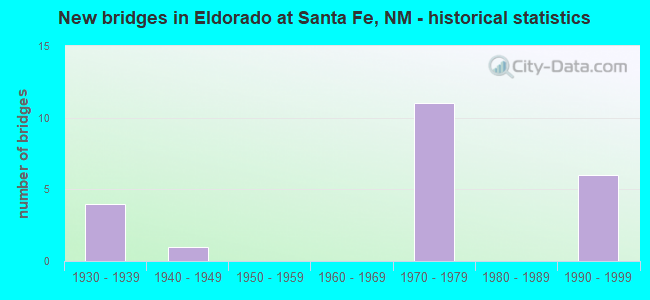
- New bridges - historical statistics
- 41930-1939
- 11940-1949
- 111970-1979
- 61990-1999

- Reconstructed bridges - Historical Statistics
- 21970-1979
- 01980-1989
- 21990-1999
- 12000-2009


- Bridge Condition - Superstructure
- 66.7%Good
- 33.3%Fair

- Bridge Condition - Substructure
- 66.7%Satisfactory
- 33.3%Fair

- Bridge Condition - Channel
- 25.0%Very good
- 37.5%Good
- 37.5%Satisfactory

- Bridge Condition - Culverts
- 6.3%Very good
- 62.5%Good
- 31.3%Satisfactory
Find on map >> Show street view
Structure Number: 386, Location: 0.6 MI S OF JCT I-25/285 (Lat: 35.546836, Lng: -105.882958), Route carried "on" structure: US 285, Year Built: 1939, Year Reconstructed: 1981, Status: Open, Structure Length: 1.19m (3.90ft), Average Daily Traffic: 9,715 (year 2020), Truck Traffic: 8%, Average Future Daily Traffic: 7,771 (year 2040), Design Load: H 15, Features Intersected: UNNAMED WATERWAY
Minimum Vertical Clearance: 30+ m (98+ ft), Kilometerpoint: 466.548, Lanes on structure: 4, Base Highway Network: Yes, Owner: State Highway Agency, Approaching Roadway Width: 17.7m (58.1ft), Skew: 4 degrees, Material/Design: Concrete continuous, Design/Construction: Culvert, Number Of Spans In Main Unit: 4, Length of Maximum Span: 2.0m (6.6ft)
Condition: Channel: Good, Culverts: Satisfactory, Operating Rating: 35.6 metric tons, Method Used To Determine Operating Rating: Load Factor (LF), Inventory Rating: 21.1 metric tons, Method Used To Determine Inventory Rating: Load Factor (LF), Structural Evaluation: Somewhat better than minimum adequacy, Waterway Adequacy: Equal to present desirable criteria, Approach Roadway Alignment: Equal to present desirable criteria, Length Of Structure Improvement: 1.20m (3.94ft), Designated Inspection Frequency: Every 48 months, Inspection Date: January 2020, Bridge Improvement Cost: $121,000, Roadway Improvement Cost: $12,000, Total Project Cost: $181,000 ( Estimate for 2030), Wearing Surface/Protective System: Wearing Surface: Bituminous
Find on map >> Show street view
Structure Number: 3861, Location: 3.0 MI S OF JCT I-25 (Lat: 35.511564, Lng: -105.896328), Route carried "on" structure: US 285, Year Built: 1939, Year Reconstructed: 2000, Status: Open, Structure Length: 2.57m (8.43ft), Average Daily Traffic: 10,768 (year 2020), Truck Traffic: 16%, Average Future Daily Traffic: 8,310 (year 2040), Design Load: H 15, Features Intersected: UNNAMED WATERWAY
Minimum Vertical Clearance: 30+ m (98+ ft), Kilometerpoint: 462.381, Lanes on structure: 4, Base Highway Network: Yes, Owner: State Highway Agency, Approaching Roadway Width: 25.4m (83.3ft), Skew: 20 degrees, Material/Design: Concrete continuous, Design/Construction: Culvert, Number Of Spans In Main Unit: 13, Length of Maximum Span: 1.8m (5.9ft)
Condition: Channel: Good, Culverts: Good, Operating Rating: 37.3 metric tons, Method Used To Determine Operating Rating: Load Factor (LF), Inventory Rating: 22.7 metric tons, Method Used To Determine Inventory Rating: Load Factor (LF), Structural Evaluation: Somewhat better than minimum adequacy, Waterway Adequacy: Equal to present desirable criteria, Approach Roadway Alignment: Equal to present desirable criteria, Length Of Structure Improvement: 2.62m (8.60ft), Designated Inspection Frequency: Every 48 months, Inspection Date: August 2018, Bridge Improvement Cost: $198,000, Roadway Improvement Cost: $19,000, Total Project Cost: $297,000 ( Estimate for 2020)
Find on map >> Show street view
Structure Number: 3862, Location: 3.6 MI S OF JCT I-25 (Lat: 35.503047, Lng: -105.899558), Route carried "on" structure: US 285, Year Built: 1939, Year Reconstructed: 1981, Status: Open, Structure Length: 0.80m (2.62ft), Average Daily Traffic: 10,768 (year 2020), Truck Traffic: 16%, Average Future Daily Traffic: 8,310 (year 2040), Design Load: H 15, Features Intersected: UNNAMED WATERWAY
Minimum Vertical Clearance: 30+ m (98+ ft), Kilometerpoint: 461.560, Lanes on structure: 4, Base Highway Network: Yes, Owner: State Highway Agency, Approaching Roadway Width: 11.0m (36.1ft), Skew: 10 degrees, Material/Design: Concrete continuous, Design/Construction: Culvert, Number Of Spans In Main Unit: 4, Length of Maximum Span: 2.0m (6.6ft)
Condition: Channel: Very good, Culverts: Good, Operating Rating: 37.3 metric tons, Method Used To Determine Operating Rating: Load Factor (LF), Inventory Rating: 22.7 metric tons, Method Used To Determine Inventory Rating: Load Factor (LF), Structural Evaluation: Somewhat better than minimum adequacy, Waterway Adequacy: Equal to present desirable criteria, Approach Roadway Alignment: Equal to present desirable criteria, Length Of Structure Improvement: 0.80m (2.62ft), Designated Inspection Frequency: Every 48 months, Inspection Date: January 2022, Bridge Improvement Cost: $60,000, Roadway Improvement Cost: $6,000, Total Project Cost: $91,000 ( Estimate for 2030)
Find on map >> Show street view
Structure Number: 4778, Location: 2.95 MI S OF JCT I-25 (Lat: 35.513256, Lng: -105.895686), Route carried "on" structure: US 285, Year Built: 1939, Status: Open, Structure Length: 0.90m (2.95ft), Average Daily Traffic: 10,768 (year 2020), Truck Traffic: 16%, Average Future Daily Traffic: 8,310 (year 2040), Design Load: H 15, Features Intersected: UNNAMED WATERWAY
Minimum Vertical Clearance: 30+ m (98+ ft), Kilometerpoint: 463.000, Lanes on structure: 4, Base Highway Network: Yes, Owner: State Highway Agency, Approaching Roadway Width: 14.6m (47.9ft), Skew: 4 degrees, Material/Design: Concrete continuous, Design/Construction: Culvert, Number Of Spans In Main Unit: 3, Length of Maximum Span: 2.0m (6.6ft)
Condition: Channel: Good, Culverts: Good, Operating Rating: 37.3 metric tons, Method Used To Determine Operating Rating: Load Factor (LF), Inventory Rating: 22.7 metric tons, Method Used To Determine Inventory Rating: Load Factor (LF), Structural Evaluation: Somewhat better than minimum adequacy, Waterway Adequacy: Equal to present desirable criteria, Approach Roadway Alignment: Equal to present desirable criteria, Length Of Structure Improvement: 0.90m (2.95ft), Designated Inspection Frequency: Every 24 months, Inspection Date: January 2022, Bridge Improvement Cost: $85,000, Roadway Improvement Cost: $8,000, Total Project Cost: $127,000 ( Estimate for 2030), Wearing Surface/Protective System: Wearing Surface: Bituminous
Find on map >> Show street view
Structure Number: 5311, Location: 0.20 MI S OF US-285 (Lat: 35.555131, Lng: -105.875139), Route carried "on" structure: State highway 300, Year Built: 1946, Status: Open, Structure Length: 2.66m (8.73ft), Average Daily Traffic: 1,554 (year 2020), Truck Traffic: 9%, Average Future Daily Traffic: 1,563 (year 2040), Design Load: HS 20, Features Intersected: CANADA DE LOS ALAMOS
Minimum Vertical Clearance: 30+ m (98+ ft), Kilometerpoint: 10.461, Lanes on structure: 2, Owner: State Highway Agency, Approaching Roadway Width: 8.0m (26.2ft), Material/Design: Concrete continuous, Design/Construction: Culvert, Number Of Spans In Main Unit: 10, Length of Maximum Span: 2.4m (7.9ft)
Condition: Channel: Satisfactory, Culverts: Satisfactory, Operating Rating: 53.5 metric tons, Method Used To Determine Operating Rating: Load Factor (LF), Inventory Rating: 32.4 metric tons, Method Used To Determine Inventory Rating: Load Factor (LF), Structural Evaluation: Equal to present minimum criteria, Waterway Adequacy: Better than present minimum criteria, Approach Roadway Alignment: Equal to present desirable criteria, Designated Inspection Frequency: Every 48 months, Inspection Date: October 2020
Find on map >> Show street view
Structure Number: 7241, Location: 1.05 MI S OF JCT US-285 (Lat: 35.567736, Lng: -105.887906), Route carried "on" structure: Interstate 25, Year Built: 1972, Status: Open, Structure Length: 0.72m (2.36ft), Average Daily Traffic: 21,239 (year 2020), Truck Traffic: 5%, Average Future Daily Traffic: 39,598 (year 2040), Design Load: HS 20, Features Intersected: ANCHO CANYON
Minimum Vertical Clearance: 30+ m (98+ ft), Kilometerpoint: 465.583, Lanes on structure: 2, Base Highway Network: Yes, Owner: State Highway Agency, Approaching Roadway Width: 15.2m (49.9ft), Skew: 13 degrees, Material/Design: Concrete continuous, Design/Construction: Culvert, Number Of Spans In Main Unit: 2, Length of Maximum Span: 3.0m (9.8ft)
Condition: Channel: Satisfactory, Culverts: Good, Operating Rating: 40.5 metric tons, Method Used To Determine Operating Rating: Load Factor (LF), Inventory Rating: 32.4 metric tons, Method Used To Determine Inventory Rating: Load Factor (LF), Structural Evaluation: Better than present minimum criteria, Waterway Adequacy: Equal to present desirable criteria, Approach Roadway Alignment: Equal to present desirable criteria, Designated Inspection Frequency: Every 48 months, Inspection Date: October 2017
Find on map >> Show street view
Structure Number: 7242, Location: 1.07 MI S OF JCT US-285 (Lat: 35.569100, Lng: -105.887700), Route carried "on" structure: Interstate 25, Year Built: 1972, Status: Open, Structure Length: 0.70m (2.30ft), Average Daily Traffic: 21,239 (year 2020), Truck Traffic: 5%, Average Future Daily Traffic: 39,598 (year 2040), Design Load: HS 20, Features Intersected: ANCHO CANYON
Minimum Vertical Clearance: 30+ m (98+ ft), Kilometerpoint: 465.582, Lanes on structure: 2, Base Highway Network: Yes, Owner: State Highway Agency, Approaching Roadway Width: 15.7m (51.5ft), Skew: 4 degrees, Material/Design: Concrete continuous, Design/Construction: Culvert, Number Of Spans In Main Unit: 2, Length of Maximum Span: 2.4m (7.9ft)
Condition: Channel: Satisfactory, Culverts: Satisfactory, Operating Rating: 40.5 metric tons, Method Used To Determine Operating Rating: Load Factor (LF), Inventory Rating: 32.4 metric tons, Method Used To Determine Inventory Rating: Load Factor (LF), Structural Evaluation: Equal to present minimum criteria, Waterway Adequacy: High priority of corrective action, Approach Roadway Alignment: Equal to present desirable criteria, Length Of Structure Improvement: 6.10m (20.01ft), Designated Inspection Frequency: Every 48 months, Inspection Date: October 2017, Bridge Improvement Cost: $100,000, Roadway Improvement Cost: $50,000, Total Project Cost: $300,000 ( Estimate for 2030)
Find on map >> Show street view
Structure Number: 7243, Location: JUNCTION I-25/US-285 (Lat: 35.554342, Lng: -105.877450), Route carried "on" structure: Ramp US 84, Year Built: 1972, Status: Open, Structure Length: 0.77m (2.53ft), Average Daily Traffic: 690 (year 2018), Truck Traffic: 22%, Average Future Daily Traffic: 1,025 (year 2038), Design Load: HS 20, Features Intersected: CANADA DE LOS ALAMOS
Minimum Vertical Clearance: 30+ m (98+ ft), Kilometerpoint: 467.685, Lanes on structure: 6, Base Highway Network: Yes, Owner: State Highway Agency, Approaching Roadway Width: 48.8m (160.1ft), Skew: 10 degrees, Material/Design: Concrete continuous, Design/Construction: Culvert, Number Of Spans In Main Unit: 3, Length of Maximum Span: 2.4m (7.9ft)
Condition: Channel: Satisfactory, Culverts: Satisfactory, Operating Rating: 51.8 metric tons, Method Used To Determine Operating Rating: Load Factor (LF), Inventory Rating: 32.4 metric tons, Method Used To Determine Inventory Rating: Load Factor (LF), Structural Evaluation: Equal to present minimum criteria, Waterway Adequacy: Equal to present desirable criteria, Approach Roadway Alignment: Equal to present desirable criteria, Length Of Structure Improvement: 0.85m (2.79ft), Designated Inspection Frequency: Every 48 months, Inspection Date: July 2020, Bridge Improvement Cost: $1,215,000, Roadway Improvement Cost: $121,000, Total Project Cost: $1,823,000 ( Estimate for 2020)
Find on map >> Show street view
Structure Number: 7277, Location: JUNCTION I-25 / US 285 (Lat: 35.554564, Lng: -105.878883), Route carried "on" structure: Interstate 25, Year Built: 1972, Year Reconstructed: 2001, Status: Open, Structure Length: 8.32m (27.30ft), Average Daily Traffic: 12,508 (year 2020), Truck Traffic: 37%, Average Future Daily Traffic: 21,412 (year 2040), Design Load: HS 20, Features Intersected: US 285
Minimum Vertical Clearance: 30+ m (98+ ft), Kilometerpoint: 467.514, Lanes on structure: 2, Lanes under structure: 4, Base Highway Network: Yes, Owner: State Highway Agency, Approaching Roadway Width: 12.8m (42.0ft), Skew: 13 degrees, Material/Design: Prestressed concrete, Design/Construction: Stringer/Multi-beam, Number Of Spans In Main Unit: 4, Length of Maximum Span: 25.3m (83.0ft), Curb-To-Curb Width: 12.8m (42.0ft), Out-to-Out Width: 13.7m (44.9ft)
Condition: Deck: Satisfactory, Superstructure: Good, Substructure: Satisfactory, Operating Rating: 53.9 metric tons, Method Used To Determine Operating Rating: Load Factor (LF), Inventory Rating: 31.9 metric tons, Method Used To Determine Inventory Rating: Load Factor (LF), Structural Evaluation: Equal to present minimum criteria, Deck Geometry: Equal to present desirable criteria, Underclear: Superior to present desirable criteria, Approach Roadway Alignment: Equal to present desirable criteria, Length Of Structure Improvement: 8.32m (27.30ft), Designated Inspection Frequency: Every 24 months, Inspection Date: April 2021, Bridge Improvement Cost: $390,000, Roadway Improvement Cost: $84,000, Total Project Cost: $630,000 ( Estimate for 2030), Deck Structure Type: Concrete Cast-file-Place, Wearing Surface/Protective System: Deck Protection: Epoxy Coated Reinforcing
Find on map >> Show street view
Structure Number: 7278, Location: JUNCTION I-25 / US 285 (Lat: 35.554783, Lng: -105.878683), Route carried "on" structure: Interstate 25, Year Built: 1972, Year Reconstructed: 2001, Status: Open, Structure Length: 8.32m (27.30ft), Average Daily Traffic: 12,508 (year 2020), Truck Traffic: 37%, Average Future Daily Traffic: 21,412 (year 2040), Design Load: HS 20, Features Intersected: US 285
Minimum Vertical Clearance: 30+ m (98+ ft), Kilometerpoint: 467.514, Lanes on structure: 2, Lanes under structure: 4, Base Highway Network: Yes, Owner: State Highway Agency, Approaching Roadway Width: 12.8m (42.0ft), Skew: 13 degrees, Material/Design: Prestressed concrete, Design/Construction: Stringer/Multi-beam, Number Of Spans In Main Unit: 4, Length of Maximum Span: 25.3m (83.0ft), Curb-To-Curb Width: 12.8m (42.0ft), Out-to-Out Width: 13.7m (44.9ft)
Condition: Deck: Satisfactory, Superstructure: Good, Substructure: Satisfactory, Operating Rating: 53.9 metric tons, Method Used To Determine Operating Rating: Load Factor (LF), Inventory Rating: 31.9 metric tons, Method Used To Determine Inventory Rating: Load Factor (LF), Structural Evaluation: Equal to present minimum criteria, Deck Geometry: Equal to present desirable criteria, Underclear: Equal to present desirable criteria, Approach Roadway Alignment: Equal to present desirable criteria, Length Of Structure Improvement: 8.32m (27.30ft), Designated Inspection Frequency: Every 24 months, Inspection Date: April 2021, Bridge Improvement Cost: $380,000, Roadway Improvement Cost: $78,000, Total Project Cost: $610,000 ( Estimate for 2030), Deck Structure Type: Concrete Cast-file-Place, Wearing Surface/Protective System: Deck Protection: Epoxy Coated Reinforcing
Find on map >> Show street view
Structure Number: 7374, Location: 5.78MN Jct I-25 StFrancis (Lat: 35.579978, Lng: -105.899483), Route carried "on" structure: State highway 2107, Year Built: 1975, Status: Open, Structure Length: 3.60m (11.81ft), Average Daily Traffic: 67 (year 2020), Truck Traffic: 16%, Average Future Daily Traffic: 125 (year 2040), Design Load: HS 20, Features Intersected: I-25 NBL
Minimum Vertical Clearance: 30+ m (98+ ft), Kilometerpoint: 0.011, Lanes on structure: 2, Lanes under structure: 2, Owner: State Highway Agency, Approaching Roadway Width: 9.8m (32.2ft), Material/Design: Steel, Design/Construction: Stringer/Multi-beam, Number Of Spans In Main Unit: 1, Length of Maximum Span: 35.7m (117.1ft), Curb-To-Curb Width: 9.8m (32.2ft), Out-to-Out Width: 10.7m (35.1ft)
Condition: Deck: Satisfactory, Superstructure: Fair, Substructure: Fair, Operating Rating: 50.2 metric tons, Method Used To Determine Operating Rating: Load Factor (LF), Inventory Rating: 32.4 metric tons, Method Used To Determine Inventory Rating: Load Factor (LF), Structural Evaluation: Somewhat better than minimum adequacy, Deck Geometry: Equal to present desirable criteria, Underclear: Equal to present minimum criteria, Approach Roadway Alignment: Equal to present desirable criteria, Designated Inspection Frequency: Every 24 months, Inspection Date: May 2020, Deck Structure Type: Concrete Cast-file-Place, Wearing Surface/Protective System: Wearing Surface: Bituminous
Find on map >> Show street view
Structure Number: 7566, Location: 1.86 MI S OF JCT US-285 (Lat: 35.578947, Lng: -105.897714), Route carried "on" structure: Interstate 25, Year Built: 1974, Status: Open, Structure Length: 0.88m (2.89ft), Average Daily Traffic: 21,239 (year 2020), Truck Traffic: 5%, Average Future Daily Traffic: 39,598 (year 2040), Design Load: HS 20, Features Intersected: CANADA ANCHA
Minimum Vertical Clearance: 30+ m (98+ ft), Kilometerpoint: 464.408, Lanes on structure: 2, Base Highway Network: Yes, Owner: State Highway Agency, Approaching Roadway Width: 15.5m (50.9ft), Skew: 4 degrees, Material/Design: Concrete continuous, Design/Construction: Culvert, Number Of Spans In Main Unit: 3, Length of Maximum Span: 1.8m (5.9ft)
Condition: Channel: Satisfactory, Culverts: Good, Operating Rating: 64.8 metric tons, Method Used To Determine Operating Rating: Load Factor (LF), Inventory Rating: 32.4 metric tons, Method Used To Determine Inventory Rating: Load Factor (LF), Structural Evaluation: Better than present minimum criteria, Waterway Adequacy: Equal to present minimum criteria, Approach Roadway Alignment: Equal to present desirable criteria, Designated Inspection Frequency: Every 48 months, Inspection Date: October 2017
Find on map >> Show street view
Structure Number: 7567, Location: 1.60 MI S OF JCT US-285 (Lat: 35.574439, Lng: -105.895442), Route carried "on" structure: Interstate 25, Year Built: 1974, Status: Open, Structure Length: 1.20m (3.94ft), Average Daily Traffic: 21,239 (year 2020), Truck Traffic: 5%, Average Future Daily Traffic: 39,598 (year 2040), Design Load: HS 20, Features Intersected: UNNAMED WATERWAY
Minimum Vertical Clearance: 0.00m, Kilometerpoint: 464.777, Lanes on structure: 2, Base Highway Network: Yes, Owner: State Highway Agency, Approaching Roadway Width: 18.0m (59.1ft), Skew: 3 degrees, Material/Design: Concrete continuous, Design/Construction: Culvert, Number Of Spans In Main Unit: 3, Length of Maximum Span: 3.0m (9.8ft)
Condition: Channel: Satisfactory, Culverts: Good, Operating Rating: 65.0 metric tons, Method Used To Determine Operating Rating: Load Factor (LF), Inventory Rating: 32.0 metric tons, Method Used To Determine Inventory Rating: Load Factor (LF), Structural Evaluation: Better than present minimum criteria, Waterway Adequacy: Somewhat better than minimum adequacy, Approach Roadway Alignment: Equal to present desirable criteria, Length Of Structure Improvement: 6.10m (20.01ft), Designated Inspection Frequency: Every 48 months, Inspection Date: January 2019, Bridge Improvement Cost: $100,000, Roadway Improvement Cost: $50,000, Total Project Cost: $300,000 ( Estimate for 2030)
Find on map >> Show street view
Structure Number: 9694, Location: 0.01 M W JCt US-285 (Lat: 35.548750, Lng: -105.883344), Route carried "on" structure: County highway 4901, Year Built: 1999, Status: Open, Structure Length: 0.69m (2.26ft), Average Daily Traffic: 2,900 (year 2020), Truck Traffic: 20%, Average Future Daily Traffic: 4,209 (year 2040), Design Load: HS 20, Features Intersected: Unnamed Waterway, Facility Carried by Structure: Avenida Amistad
Minimum Vertical Clearance: 30+ m (98+ ft), Kilometerpoint: 0.161, Lanes on structure: 2, Owner: County Highway Agency, Approaching Roadway Width: 6.9m (22.6ft), Material/Design: Steel, Design/Construction: Culvert, Number Of Spans In Main Unit: 1, Length of Maximum Span: 6.9m (22.6ft), Out-to-Out Width: 33.8m (110.9ft)
Condition: Channel: Very good, Culverts: Very good, Operating Rating: 54.7 metric tons, Method Used To Determine Operating Rating: Load Factor (LF), Inventory Rating: 32.7 metric tons, Method Used To Determine Inventory Rating: Load Factor (LF), Structural Evaluation: Equal to present desirable criteria, Waterway Adequacy: Better than present minimum criteria, Approach Roadway Alignment: Better than present minimum criteria, Designated Inspection Frequency: Every 48 months, Inspection Date: January 2019
Find on map >> Show street view
Structure Number: 9695, Location: 0.01 M W JCt US-285 (Lat: 35.537053, Lng: -105.888006), Route carried "on" structure: County highway 4901, Year Built: 1999, Status: Open, Structure Length: 1.31m (4.30ft), Average Daily Traffic: 2,317 (year 2020), Truck Traffic: 20%, Average Future Daily Traffic: 3,362 (year 2040), Design Load: HS 20, Features Intersected: Unnamed Waterway, Facility Carried by Structure: Ave Vista Grande
Minimum Vertical Clearance: 30+ m (98+ ft), Kilometerpoint: 0.016, Lanes on structure: 2, Owner: County Highway Agency, Approaching Roadway Width: 12.4m (40.7ft), Material/Design: Concrete continuous, Design/Construction: Culvert, Number Of Spans In Main Unit: 5, Length of Maximum Span: 2.4m (7.9ft)
Condition: Channel: Good, Culverts: Satisfactory, Operating Rating: 58.8 metric tons, Method Used To Determine Operating Rating: Load Factor (LF), Inventory Rating: 32.7 metric tons, Method Used To Determine Inventory Rating: Load Factor (LF), Structural Evaluation: Equal to present minimum criteria, Waterway Adequacy: Better than present minimum criteria, Approach Roadway Alignment: Better than present minimum criteria, Designated Inspection Frequency: Every 48 months, Inspection Date: January 2019
Find on map >> Show street view
Structure Number: 9696, Location: 3.3 M W Jct US-285 (Lat: 35.549256, Lng: -105.944906), Route carried "on" structure: County highway 4901, Year Built: 1999, Status: Open, Structure Length: 1.31m (4.30ft), Average Daily Traffic: 270 (year 2020), Average Future Daily Traffic: 431 (year 2040), Features Intersected: Unnamed Waterway, Facility Carried by Structure: Ave De Compadres
Minimum Vertical Clearance: 30+ m (98+ ft), Kilometerpoint: 0.000, Lanes on structure: 2, Owner: County Highway Agency, Approaching Roadway Width: 7.4m (24.3ft), Material/Design: Concrete continuous, Design/Construction: Culvert, Number Of Spans In Main Unit: 5, Length of Maximum Span: 2.4m (7.9ft)
Condition: Channel: Very good, Culverts: Good, Operating Rating: 53.9 metric tons, Method Used To Determine Operating Rating: Load Factor (LF), Inventory Rating: 32.7 metric tons, Method Used To Determine Inventory Rating: Load Factor (LF), Structural Evaluation: Better than present minimum criteria, Waterway Adequacy: Equal to present desirable criteria, Approach Roadway Alignment: Better than present minimum criteria, Designated Inspection Frequency: Every 48 months, Inspection Date: January 2019
Find on map >> Show street view
Structure Number: 9697, Location: 4.2 M W Jct US-285 (Lat: 35.553700, Lng: -105.961483), Route carried "on" structure: County highway 4901, Year Built: 1999, Status: Open, Structure Length: 0.79m (2.59ft), Average Daily Traffic: 701 (year 2020), Truck Traffic: 9%, Average Future Daily Traffic: 5,664 (year 2040), Design Load: HS 20, Features Intersected: Unnamed Waterway, Facility Carried by Structure: Avenida Azul
Minimum Vertical Clearance: 30+ m (98+ ft), Kilometerpoint: 1.287, Lanes on structure: 2, Owner: County Highway Agency, Approaching Roadway Width: 7.8m (25.6ft), Material/Design: Concrete continuous, Design/Construction: Culvert, Number Of Spans In Main Unit: 3, Length of Maximum Span: 2.4m (7.9ft)
Condition: Channel: Very good, Culverts: Good, Operating Rating: 58.8 metric tons, Method Used To Determine Operating Rating: Load Factor (LF), Inventory Rating: 32.7 metric tons, Method Used To Determine Inventory Rating: Load Factor (LF), Structural Evaluation: Better than present minimum criteria, Waterway Adequacy: Better than present minimum criteria, Approach Roadway Alignment: Better than present minimum criteria, Designated Inspection Frequency: Every 48 months, Inspection Date: January 2019
Find on map >> Show street view
Structure Number: 9698, Location: 2.8 M W Jct US-285 (Lat: 35.522689, Lng: -105.938797), Route carried "on" structure: County highway 4901, Year Built: 1999, Status: Open, Structure Length: 1.16m (3.81ft), Average Daily Traffic: 853 (year 2020), Truck Traffic: 20%, Average Future Daily Traffic: 1,238 (year 2040), Design Load: HS 20, Features Intersected: Unnamed Waterway, Facility Carried by Structure: Avenida El Dorado
Minimum Vertical Clearance: 30+ m (98+ ft), Kilometerpoint: 4.506, Lanes on structure: 2, Owner: County Highway Agency, Approaching Roadway Width: 9.8m (32.2ft), Material/Design: Concrete continuous, Design/Construction: Culvert, Number Of Spans In Main Unit: 4, Length of Maximum Span: 2.7m (8.9ft)
Condition: Channel: Good, Culverts: Good, Operating Rating: 58.8 metric tons, Method Used To Determine Operating Rating: Load Factor (LF), Inventory Rating: 32.7 metric tons, Method Used To Determine Inventory Rating: Load Factor (LF), Structural Evaluation: Better than present minimum criteria, Waterway Adequacy: Better than present minimum criteria, Approach Roadway Alignment: Equal to present desirable criteria, Designated Inspection Frequency: Every 48 months, Inspection Date: January 2019
Find on map >> Show street view
Structure Number: 9699, Location: 0.1 Miles W. Jct. 84/285 (Lat: 35.529700, Lng: -105.893119), Route carried "on" structure: County highway 4900, Year Built: 1995, Status: Open, Structure Length: 1.86m (6.10ft), Average Daily Traffic: 853 (year 2020), Truck Traffic: 20%, Average Future Daily Traffic: 1,238 (year 2040), Design Load: HS 20, Features Intersected: Unnamed waterway, Facility Carried by Structure: Avenida El Dorado
Minimum Vertical Clearance: 30+ m (98+ ft), Kilometerpoint: 0.161, Lanes on structure: 2, Owner: County Highway Agency, Approaching Roadway Width: 12.0m (39.4ft), Material/Design: Concrete continuous, Design/Construction: Culvert, Number Of Spans In Main Unit: 8, Length of Maximum Span: 2.4m (7.9ft), Curb-To-Curb Width: 14.4m (47.2ft), Out-to-Out Width: 15.3m (50.2ft)
Condition: Channel: Good, Culverts: Good, Operating Rating: 53.9 metric tons, Method Used To Determine Operating Rating: Load Factor (LF), Inventory Rating: 32.7 metric tons, Method Used To Determine Inventory Rating: Load Factor (LF), Structural Evaluation: Better than present minimum criteria, Deck Geometry: Superior to present desirable criteria, Waterway Adequacy: Better than present minimum criteria, Approach Roadway Alignment: Better than present minimum criteria, Designated Inspection Frequency: Every 48 months, Inspection Date: January 2019
Find on map >> Show street view
Structure Number: 7277, Location: JUNCTION I-25 / US 285 (Lat: 35.554564, Lng: -105.878883), Route carried "under" structure: US 285, Year Built: 1972, Structure Length: 0. m, Average Daily Traffic: 8,198 (year 2020), Truck Traffic: 8%, Features Intersected: US 285, Facility Carried by Structure: I-25 NBL
Minimum Vertical Clearance: 5.61m (18.41ft), Kilometerpoint: 467.353, Lanes on structure: 2, Lanes under structure: 4, Material/Design: Prestressed concrete, Design/Construction: Stringer/Multi-beam, Length of Maximum Span: 25.3m (83.0ft)
Find on map >> Show street view
Structure Number: 7278, Location: JUNCTION I-25 / US 285 (Lat: 35.554783, Lng: -105.878683), Route carried "under" structure: US 285, Year Built: 1972, Structure Length: 0. m, Average Daily Traffic: 8,198 (year 2020), Truck Traffic: 8%, Features Intersected: US 285, Facility Carried by Structure: I-25 SBL
Minimum Vertical Clearance: 5.27m (17.29ft), Kilometerpoint: 467.353, Lanes on structure: 2, Lanes under structure: 4, Material/Design: Prestressed concrete, Design/Construction: Stringer/Multi-beam, Length of Maximum Span: 25.3m (83.0ft)
Find on map >> Show street view
Structure Number: 7374, Location: 5.78MN Jct I-25 StFrancis (Lat: 35.579978, Lng: -105.899483), Route carried "under" structure: Interstate 25, Year Built: 1975, Structure Length: 0. m, Average Daily Traffic: 21,239 (year 2020), Truck Traffic: 5%, Features Intersected: I-25 NBL, Facility Carried by Structure: FR2107
Minimum Vertical Clearance: 5.09m (16.70ft), Kilometerpoint: 463.974, Lanes on structure: 2, Lanes under structure: 2, Material/Design: Steel, Design/Construction: Stringer/Multi-beam, Length of Maximum Span: 35.7m (117.1ft)