Bridge Statistics for Elsmere, Delaware (DE)
Condition, Traffic, Stress, Structural Evaluation, Project Costs
- National Bridge Inventory (NBI) Statistics
- 30Number of bridges
- 525ft / 160mTotal length
- $14,382,000Total costs
- 567,559Total average daily traffic
- 47,403Total average daily truck traffic
- National Bridge Inventory (NBI) Registered Bridges for Elsmere
- No street view available for this location
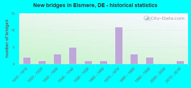
- New bridges - historical statistics
- 21910-1919
- 11920-1929
- 31930-1939
- 51940-1949
- 11950-1959
- 11960-1969
- 111970-1979
- 31980-1989
- 21990-1999
- 12010-2019

- Reconstructed bridges - Historical Statistics
- 31980-1989
- 41990-1999
- 32000-2009
- 12010-2019


- Bridge Condition - Deck
- 6.3%Very good
- 56.3%Good
- 37.5%Satisfactory

- Bridge Condition - Superstructure
- 11.8%Very good
- 29.4%Good
- 52.9%Satisfactory
- 5.9%Fair

- Bridge Condition - Substructure
- 29.4%Good
- 52.9%Satisfactory
- 17.6%Fair

- Bridge Condition - Channel
- 56.3%Good
- 37.5%Satisfactory
- 6.3%Fair

- Bridge Condition - Culverts
- 40.0%Good
- 40.0%Satisfactory
- 20.0%Fair
Find on map >> Show street view
Structure Number: 1143 271, Location: N.E. OF PRICES CORNER (Lat: 39.742711, Lng: -75.614653), Route carried "on" structure: State highway 141, Year Built: 2010, Status: Open, Structure Length: 2.06m (6.76ft), Average Daily Traffic: 29,679 (year 2019), Truck Traffic: 9%, Average Future Daily Traffic: 36,888 (year 2042), Design Load: HS 20+Mod, Features Intersected: LITTLE MILL CREEK
Minimum Vertical Clearance: 30.48m (100.00ft), Kilometerpoint: 0.708, Lanes on structure: 4, Base Highway Network: Yes, Owner: State Highway Agency, Approaching Roadway Width: 21.9m (71.9ft), Skew: 33 degrees, Material/Design: Prestressed concrete, Design/Construction: Box Beam or Girders - Multiple, Number Of Spans In Main Unit: 1, Length of Maximum Span: 19.2m (63.0ft), Curb or Sidewalk Widths: Left: 1.8m (5.9ft), Right: 4.3m (14.1ft), Curb-To-Curb Width: 23.2m (76.1ft), Out-to-Out Width: 34.5m (113.2ft)
Condition: Deck: Good, Superstructure: Good, Substructure: Good, Channel: Good, Operating Rating: 75.2 metric tons, Method Used To Determine Operating Rating: Load and Resistance Factor Rating (LRFR) rating reported by rating factor(RF) method using HL-93 loadings, Inventory Rating: 56.7 metric tons, Method Used To Determine Inventory Rating: Load and Resistance Factor Rating (LRFR) rating reported by rating factor(RF) method using HL-93 loadings, Structural Evaluation: Better than present minimum criteria, Deck Geometry: Superior to present desirable criteria, Waterway Adequacy: Equal to present minimum criteria, Approach Roadway Alignment: Equal to present desirable criteria, Length Of Structure Improvement: 1.37m (4.49ft), Designated Inspection Frequency: Every 24 months, Inspection Date: May 2020, Bridge Improvement Cost: $260,000, Roadway Improvement Cost: $26,000, Total Project Cost: $389,000, Deck Structure Type: Concrete Cast-file-Place, Wearing Surface/Protective System: Wearing Surface: Monolithic Concrete, Deck Protection: Epoxy Coated Reinforcing
Find on map >> Show street view
Structure Number: 1145 27, Location: NORTH OF PRICES CORNER (Lat: 39.748089, Lng: -75.618225), Route carried "on" structure: State highway 34, Year Built: 1967, Status: Open, Structure Length: 1.38m (4.53ft), Average Daily Traffic: 9,846 (year 2019), Truck Traffic: 9%, Average Future Daily Traffic: 12,237 (year 2042), Design Load: HS 20, Features Intersected: LITTLE MILL CREEK
Minimum Vertical Clearance: 30.48m (100.00ft), Kilometerpoint: 2.770, Lanes on structure: 2, Owner: State Highway Agency, Approaching Roadway Width: 14.0m (45.9ft), Skew: 4 degrees, Material/Design: Concrete, Design/Construction: Culvert, Number Of Spans In Main Unit: 3, Length of Maximum Span: 4.3m (14.1ft)
Condition: Channel: Satisfactory, Culverts: Satisfactory, Operating Rating: 70.3 metric tons, Method Used To Determine Operating Rating: Load and Resistance Factor Rating (LRFR) rating reported by rating factor(RF) method using HL-93 loadings, Inventory Rating: 54.4 metric tons, Method Used To Determine Inventory Rating: Load and Resistance Factor Rating (LRFR) rating reported by rating factor(RF) method using HL-93 loadings, Structural Evaluation: Equal to present minimum criteria, Waterway Adequacy: Equal to present minimum criteria, Approach Roadway Alignment: Equal to present desirable criteria, Designated Inspection Frequency: Every 24 months, Inspection Date: April 2020
Find on map >> Show street view
Structure Number: 1150 011B, Location: ELSMERE (Lat: 39.740881, Lng: -75.585153), Route carried "on" structure: County highway 11B, Year Built: 1917, Year Reconstructed: 2000, Status: Open, Structure Length: 0.70m (2.30ft), Average Daily Traffic: 712 (year 2019), Truck Traffic: 9%, Average Future Daily Traffic: 884 (year 2042), Design Load: HS 25 or greater, Features Intersected: WATERWAY, Facility Carried by Structure: NEW ROAD
Minimum Vertical Clearance: 30.48m (100.00ft), Kilometerpoint: 0.161, Lanes on structure: 2, Owner: State Highway Agency, Approaching Roadway Width: 11.6m (38.1ft), Skew: 1 degrees, Material/Design: Prestressed concrete, Design/Construction: Box Beam or Girders - Multiple, Number Of Spans In Main Unit: 1, Length of Maximum Span: 6.2m (20.3ft), Curb or Sidewalk Widths: Left: 1.9m (6.2ft), Right: 1.9m (6.2ft), Curb-To-Curb Width: 10.2m (33.5ft), Out-to-Out Width: 14.2m (46.6ft)
Condition: Deck: Good, Superstructure: Good, Substructure: Satisfactory, Channel: Good, Operating Rating: 31.8 metric tons, Method Used To Determine Operating Rating: Load and Resistance Factor Rating (LRFR) rating reported by rating factor(RF) method using HL-93 loadings, Inventory Rating: 24.9 metric tons, Method Used To Determine Inventory Rating: Load and Resistance Factor Rating (LRFR) rating reported by rating factor(RF) method using HL-93 loadings, Structural Evaluation: Equal to present minimum criteria, Deck Geometry: Equal to present minimum criteria, Waterway Adequacy: Better than present minimum criteria, Approach Roadway Alignment: Equal to present desirable criteria, Designated Inspection Frequency: Every 24 months, Inspection Date: May 2020, Deck Structure Type: Concrete Cast-file-Place, Wearing Surface/Protective System: Wearing Surface: Monolithic Concrete, Deck Protection: Epoxy Coated Reinforcing
Find on map >> Show street view
Structure Number: 1151 011C, Location: ELSMERE (Lat: 39.739892, Lng: -75.593667), Route carried "on" structure: County highway 11C, Year Built: 1917, Year Reconstructed: 2000, Status: Open, Structure Length: 0.88m (2.89ft), Average Daily Traffic: 1,389 (year 2019), Truck Traffic: 8%, Average Future Daily Traffic: 1,742 (year 2043), Design Load: HS 20, Features Intersected: LITTLE MILL CREEK, Facility Carried by Structure: NEW ROAD
Minimum Vertical Clearance: 30.48m (100.00ft), Kilometerpoint: 0.400, Lanes on structure: 2, Owner: State Highway Agency, Approaching Roadway Width: 10.4m (34.1ft), Material/Design: Prestressed concrete, Design/Construction: Box Beam or Girders - Single/Spread, Number Of Spans In Main Unit: 1, Length of Maximum Span: 6.8m (22.3ft), Curb or Sidewalk Widths: Left: 2.1m (6.9ft), Right: 2.1m (6.9ft), Curb-To-Curb Width: 10.4m (34.1ft), Out-to-Out Width: 15.4m (50.5ft)
Condition: Deck: Good, Superstructure: Very good, Substructure: Satisfactory, Channel: Good, Operating Rating: 54.1 metric tons, Method Used To Determine Operating Rating: Load and Resistance Factor Rating (LRFR) rating reported by rating factor(RF) method using HL-93 loadings, Inventory Rating: 42.8 metric tons, Method Used To Determine Inventory Rating: Load and Resistance Factor Rating (LRFR) rating reported by rating factor(RF) method using HL-93 loadings, Structural Evaluation: Equal to present minimum criteria, Deck Geometry: Equal to present minimum criteria, Waterway Adequacy: Equal to present minimum criteria, Approach Roadway Alignment: Equal to present desirable criteria, Designated Inspection Frequency: Every 24 months, Inspection Date: Febuary 2021, Bridge Improvement Cost: $283,000, Total Project Cost: $283,000, Deck Structure Type: Concrete Cast-file-Place, Wearing Surface/Protective System: Wearing Surface: Monolithic Concrete, Deck Protection: Epoxy Coated Reinforcing
Find on map >> Show street view
Structure Number: 1152 011, Location: ELSMERE (Lat: 39.738717, Lng: -75.604650), Route carried "on" structure: State highway 2, Year Built: 1939, Year Reconstructed: 2002, Status: Open, Structure Length: 0.79m (2.59ft), Average Daily Traffic: 30,473 (year 2019), Truck Traffic: 9%, Average Future Daily Traffic: 38,235 (year 2043), Design Load: HS 20+Mod, Features Intersected: CHESTNUT RUN
Minimum Vertical Clearance: 30.48m (100.00ft), Kilometerpoint: 19.570, Lanes on structure: 4, Base Highway Network: Yes, Owner: State Highway Agency, Approaching Roadway Width: 19.8m (65.0ft), Skew: 20 degrees, Material/Design: Concrete, Design/Construction: Slab, Number Of Spans In Main Unit: 1, Length of Maximum Span: 6.7m (22.0ft), Curb or Sidewalk Widths: Left: 1.4m (4.6ft), Right: 1.4m (4.6ft), Curb-To-Curb Width: 24.5m (80.4ft), Out-to-Out Width: 33.2m (108.9ft)
Condition: Deck: Good, Superstructure: Good, Substructure: Satisfactory, Channel: Satisfactory, Operating Rating: 44.1 metric tons, Method Used To Determine Operating Rating: Load and Resistance Factor Rating (LRFR) rating reported by rating factor(RF) method using HL-93 loadings, Inventory Rating: 34.0 metric tons, Method Used To Determine Inventory Rating: Load and Resistance Factor Rating (LRFR) rating reported by rating factor(RF) method using HL-93 loadings, Structural Evaluation: Equal to present minimum criteria, Deck Geometry: Superior to present desirable criteria, Waterway Adequacy: Equal to present minimum criteria, Approach Roadway Alignment: Equal to present desirable criteria, Length Of Structure Improvement: 0.79m (2.59ft), Designated Inspection Frequency: Every 24 months, Inspection Date: Febuary 2021, Bridge Improvement Cost: $283,000, Roadway Improvement Cost: $28,000, Total Project Cost: $425,000, Deck Structure Type: Concrete Cast-file-Place, Wearing Surface/Protective System: Wearing Surface: Monolithic Concrete, Deck Protection: Epoxy Coated Reinforcing
Find on map >> Show street view
Structure Number: 1153 011, Location: ELSMERE (Lat: 39.738392, Lng: -75.607653), Route carried "on" structure: State highway 2, Year Built: 1939, Year Reconstructed: 1998, Status: Posted for load, Structure Length: 1.03m (3.38ft), Average Daily Traffic: 30,473 (year 2019), Truck Traffic: 9%, Average Future Daily Traffic: 37,875 (year 2042), Design Load: H 20, Features Intersected: LITTLE MILL CREEK
Minimum Vertical Clearance: 30.48m (100.00ft), Kilometerpoint: 19.510, Lanes on structure: 4, Base Highway Network: Yes, Owner: State Highway Agency, Approaching Roadway Width: 19.6m (64.3ft), Skew: 30 degrees, Material/Design: Concrete, Design/Construction: Culvert, Number Of Spans In Main Unit: 2, Length of Maximum Span: 4.9m (16.1ft), Curb or Sidewalk Widths: Left: 2.1m (6.9ft), Right: 1.5m (4.9ft), Curb-To-Curb Width: 19.6m (64.3ft), Out-to-Out Width: 29.0m (95.1ft)
Condition: Channel: Good, Culverts: Satisfactory, Operating Rating: 26.9 metric tons, Method Used To Determine Operating Rating: Load and Resistance Factor Rating (LRFR) rating reported by rating factor(RF) method using HL-93 loadings, Inventory Rating: 20.7 metric tons, Method Used To Determine Inventory Rating: Load and Resistance Factor Rating (LRFR) rating reported by rating factor(RF) method using HL-93 loadings, Structural Evaluation: Somewhat better than minimum adequacy, Deck Geometry: Better than present minimum criteria, Waterway Adequacy: Equal to present minimum criteria, Approach Roadway Alignment: Equal to present desirable criteria, Bridge Posting: Required (Relationship of Operating Rating to Maximum Legal Load: 10.0 - 19.9% below), Designated Inspection Frequency: Every 24 months, Inspection Date: June 2020, Deck Structure Type: Concrete Cast-file-Place, Wearing Surface/Protective System: Wearing Surface: Bituminous
Find on map >> Show street view
Structure Number: 1160 336, Location: WEST OF WILMINGTON (Lat: 39.732014, Lng: -75.580444), Route carried "on" structure: State highway 4, Year Built: 1931, Status: Open, Structure Length: 1.52m (4.99ft), Average Daily Traffic: 19,793 (year 2019), Truck Traffic: 9%, Average Future Daily Traffic: 24,601 (year 2042), Design Load: HL 93, Features Intersected: LITTLE MILL CREEK
Minimum Vertical Clearance: 30.48m (100.00ft), Kilometerpoint: 8.546, Lanes on structure: 4, Base Highway Network: Yes, Owner: State Highway Agency, Approaching Roadway Width: 17.1m (56.1ft), Material/Design: Concrete, Design/Construction: Arch - Deck, Number Of Spans In Main Unit: 1, Length of Maximum Span: 15.2m (49.9ft), Curb or Sidewalk Widths: Left: 1.8m (5.9ft), Right: 1.8m (5.9ft), Curb-To-Curb Width: 14.6m (47.9ft), Out-to-Out Width: 19.1m (62.7ft)
Condition: Superstructure: Satisfactory, Substructure: Good, Channel: Good, Operating Rating: 48.3 metric tons, Method Used To Determine Operating Rating: Load and Resistance Factor Rating (LRFR) rating reported by rating factor(RF) method using HL-93 loadings, Inventory Rating: 37.3 metric tons, Method Used To Determine Inventory Rating: Load and Resistance Factor Rating (LRFR) rating reported by rating factor(RF) method using HL-93 loadings, Structural Evaluation: Equal to present minimum criteria, Deck Geometry: High priority of replacement, Waterway Adequacy: Equal to present minimum criteria, Approach Roadway Alignment: Equal to present desirable criteria, Length Of Structure Improvement: 1.77m (5.81ft), Designated Inspection Frequency: Every 24 months, Inspection Date: July 2020, Bridge Improvement Cost: $360,000, Roadway Improvement Cost: $36,000, Total Project Cost: $539,000
Find on map >> Show street view
Structure Number: 1161 027A, Location: ELSMERE (Lat: 39.734761, Lng: -75.587033), Route carried "on" structure: County highway 27A, Year Built: 1926, Year Reconstructed: 2000, Status: Open, Structure Length: 1.16m (3.81ft), Average Daily Traffic: 4,442 (year 2020), Truck Traffic: 8%, Average Future Daily Traffic: 5,521 (year 2043), Design Load: H 20, Features Intersected: LITTLE MILL CREEK, Facility Carried by Structure: OLD DUPONT RD.
Minimum Vertical Clearance: 30.48m (100.00ft), Kilometerpoint: 0.160, Lanes on structure: 2, Owner: State Highway Agency, Approaching Roadway Width: 7.6m (24.9ft), Material/Design: Steel, Design/Construction: Stringer/Multi-beam, Number Of Spans In Main Unit: 1, Length of Maximum Span: 10.4m (34.1ft), Curb or Sidewalk Widths: Left: 1.4m (4.6ft), Right: 0.0m, Curb-To-Curb Width: 8.5m (27.9ft), Out-to-Out Width: 9.4m (30.8ft)
Condition: Deck: Satisfactory, Superstructure: Satisfactory, Substructure: Good, Channel: Good, Operating Rating: 57.7 metric tons, Method Used To Determine Operating Rating: Load and Resistance Factor Rating (LRFR) rating reported by rating factor(RF) method using HL-93 loadings, Inventory Rating: 44.4 metric tons, Method Used To Determine Inventory Rating: Load and Resistance Factor Rating (LRFR) rating reported by rating factor(RF) method using HL-93 loadings, Structural Evaluation: Equal to present minimum criteria, Deck Geometry: Meets minimum limits, Waterway Adequacy: Superior to present desirable criteria, Approach Roadway Alignment: Equal to present desirable criteria, Designated Inspection Frequency: Every 24 months, Inspection Date: Febuary 2021, Deck Structure Type: Concrete Cast-file-Place, Wearing Surface/Protective System: Wearing Surface: Bituminous
Find on map >> Show street view
Structure Number: 1498, Location: ELSMERE (Lat: 39.736783, Lng: -75.606561), Route carried "on" structure: City street , Year Built: 1978, Status: Open, Structure Length: 1.13m (3.71ft), Average Daily Traffic: 99 (year 2020), Truck Traffic: 13%, Average Future Daily Traffic: 123 (year 2042), Design Load: HS 20, Features Intersected: CHESTNUT RUN, Facility Carried by Structure: MAPLE AVE
Minimum Vertical Clearance: 30.48m (100.00ft), Kilometerpoint: 0.805, Lanes on structure: 2, Owner: City or Municipal Highway Agency, Approaching Roadway Width: 8.5m (27.9ft), Skew: 1 degrees, Material/Design: Aluminum, Iron, Design/Construction: Culvert, Number Of Spans In Main Unit: 3, Length of Maximum Span: 2.6m (8.5ft)
Condition: Channel: Fair, Culverts: Fair, Operating Rating: 89.8 metric tons, Method Used To Determine Operating Rating: Field evaluation and documented engineering judgment, Inventory Rating: 74.4 metric tons, Method Used To Determine Inventory Rating: Field evaluation and documented engineering judgment, Structural Evaluation: Somewhat better than minimum adequacy, Waterway Adequacy: Better than present minimum criteria, Approach Roadway Alignment: Equal to present desirable criteria, Designated Inspection Frequency: Every 12 months, Inspection Date: July 2021
Find on map >> Show street view
Structure Number: 1499, Location: ELSMERE (Lat: 39.737256, Lng: -75.605781), Route carried "on" structure: City street , Year Built: 1996, Status: Open, Structure Length: 0.80m (2.62ft), Average Daily Traffic: 99 (year 2019), Truck Traffic: 11%, Average Future Daily Traffic: 123 (year 2042), Design Load: HS 25 or greater, Features Intersected: CHESTNUT RUN, Facility Carried by Structure: FORREST AVE
Minimum Vertical Clearance: 30.48m (100.00ft), Kilometerpoint: 0.016, Lanes on structure: 2, Owner: State Highway Agency, Approaching Roadway Width: 6.6m (21.7ft), Skew: 3 degrees, Material/Design: Concrete, Design/Construction: Culvert, Number Of Spans In Main Unit: 1, Length of Maximum Span: 8.0m (26.2ft), Curb or Sidewalk Widths: Left: 0.0m, Right: 1.8m (5.9ft), Curb-To-Curb Width: 6.6m (21.7ft), Out-to-Out Width: 10.9m (35.8ft)
Condition: Channel: Satisfactory, Culverts: Good, Operating Rating: 70.3 metric tons, Method Used To Determine Operating Rating: Load and Resistance Factor Rating (LRFR) rating reported by rating factor(RF) method using HL-93 loadings, Inventory Rating: 54.1 metric tons, Method Used To Determine Inventory Rating: Load and Resistance Factor Rating (LRFR) rating reported by rating factor(RF) method using HL-93 loadings, Structural Evaluation: Better than present minimum criteria, Deck Geometry: Somewhat better than minimum adequacy, Waterway Adequacy: Equal to present minimum criteria, Approach Roadway Alignment: Equal to present desirable criteria, Designated Inspection Frequency: Every 24 months, Inspection Date: June 2020, Deck Structure Type: Concrete Cast-file-Place, Wearing Surface/Protective System: Wearing Surface: Integral Concrete, Deck Protection: Epoxy Coated Reinforcing
Find on map >> Show street view
Structure Number: 1600 006, Location: PRICES CORNER (Lat: 39.737606, Lng: -75.619692), Route carried "on" structure: State highway 141, Year Built: 1972, Year Reconstructed: 1999, Status: Open, Structure Length: 5.66m (18.57ft), Average Daily Traffic: 46,466 (year 2019), Truck Traffic: 9%, Average Future Daily Traffic: 58,302 (year 2043), Design Load: HS 20, Features Intersected: SR 2, KIRKWOOD HWY.
Minimum Vertical Clearance: 30.48m (100.00ft), Kilometerpoint: 9.737, Lanes on structure: 6, Lanes under structure: 6, Base Highway Network: Yes, Owner: State Highway Agency, Approaching Roadway Width: 40.8m (133.9ft), Skew: 33 degrees, Material/Design: Steel continuous, Design/Construction: Stringer/Multi-beam, Number Of Spans In Main Unit: 2, Length of Maximum Span: 27.4m (89.9ft), Curb-To-Curb Width: 14.2m (46.6ft), Out-to-Out Width: 47.5m (155.8ft)
Condition: Deck: Good, Superstructure: Satisfactory, Substructure: Satisfactory, Inventory Rating: 47.2 metric tons, Method Used To Determine Inventory Rating: Load Factor (LF), Structural Evaluation: Equal to present minimum criteria, Deck Geometry: High priority of replacement, Underclear: Somewhat better than minimum adequacy, Approach Roadway Alignment: Equal to present desirable criteria, Length Of Structure Improvement: 6.10m (20.01ft), Designated Inspection Frequency: Every 24 months, Inspection Date: Febuary 2021, Bridge Improvement Cost: $1,000,000, Roadway Improvement Cost: $100,000, Total Project Cost: $1,100,000, Deck Structure Type: Concrete Cast-file-Place, Wearing Surface/Protective System: Wearing Surface: Latex Concrete
Find on map >> Show street view
Structure Number: 1601 6003, Location: PRICES CORNER (Lat: 39.737575, Lng: -75.620308), Route carried "on" structure: Ramp State highway , Year Built: 1972, Status: Open, Structure Length: 5.49m (18.01ft), Average Daily Traffic: 11,103 (year 2019), Truck Traffic: 6%, Average Future Daily Traffic: 13,800 (year 2042), Design Load: HS 20, Features Intersected: SR 2, KIRKWOOD HWY., Facility Carried by Structure: RAMP SR2WB-SR141SB
Minimum Vertical Clearance: 30.48m (100.00ft), Kilometerpoint: 0.210, Lanes on structure: 1, Lanes under structure: 6, Owner: State Highway Agency, Approaching Roadway Width: 9.1m (29.9ft), Skew: 2 degrees, Material/Design: Steel continuous, Design/Construction: Stringer/Multi-beam, Number Of Spans In Main Unit: 2, Length of Maximum Span: 27.4m (89.9ft), Curb-To-Curb Width: 9.1m (29.9ft), Out-to-Out Width: 10.1m (33.1ft)
Condition: Deck: Satisfactory, Superstructure: Satisfactory, Substructure: Fair, Operating Rating: 39.9 metric tons, Method Used To Determine Operating Rating: Load and Resistance Factor Rating (LRFR) rating reported by rating factor(RF) method using HL-93 loadings, Inventory Rating: 31.1 metric tons, Method Used To Determine Inventory Rating: Load and Resistance Factor Rating (LRFR) rating reported by rating factor(RF) method using HL-93 loadings, Structural Evaluation: Somewhat better than minimum adequacy, Deck Geometry: Superior to present desirable criteria, Underclear: Somewhat better than minimum adequacy, Approach Roadway Alignment: Equal to present desirable criteria, Designated Inspection Frequency: Every 24 months, Inspection Date: June 2020, Deck Structure Type: Concrete Cast-file-Place, Wearing Surface/Protective System: Wearing Surface: Monolithic Concrete
Find on map >> Show street view
Structure Number: 1604 006, Location: PRICES CORNER (Lat: 39.739117, Lng: -75.618664), Route carried "on" structure: State highway 141, Year Built: 1972, Year Reconstructed: 1999, Status: Open, Structure Length: 2.74m (8.99ft), Average Daily Traffic: 46,466 (year 2019), Truck Traffic: 9%, Average Future Daily Traffic: 57,753 (year 2042), Design Load: HS 20, Features Intersected: RAMP SR 2WB TO SR 141SB
Minimum Vertical Clearance: 30.48m (100.00ft), Kilometerpoint: 9.785, Lanes on structure: 6, Lanes under structure: 1, Base Highway Network: Yes, Owner: State Highway Agency, Approaching Roadway Width: 43.9m (144.0ft), Skew: 23 degrees, Material/Design: Steel, Design/Construction: Stringer/Multi-beam, Number Of Spans In Main Unit: 1, Length of Maximum Span: 25.6m (84.0ft), Curb-To-Curb Width: 40.1m (131.6ft), Out-to-Out Width: 45.0m (147.6ft)
Condition: Deck: Satisfactory, Superstructure: Fair, Substructure: Fair, Operating Rating: 64.4 metric tons, Method Used To Determine Operating Rating: Load Factor (LF), Inventory Rating: 38.1 metric tons, Method Used To Determine Inventory Rating: Load Factor (LF), Structural Evaluation: Somewhat better than minimum adequacy, Deck Geometry: Superior to present desirable criteria, Underclear: Meets minimum limits, Approach Roadway Alignment: Equal to present desirable criteria, Designated Inspection Frequency: Every 24 months, Inspection Date: April 2020, Deck Structure Type: Concrete Cast-file-Place, Wearing Surface/Protective System: Wearing Surface: Monolithic Concrete
Find on map >> Show street view
Structure Number: 1606 006, Location: S/W OF ELSMERE (Lat: 39.733556, Lng: -75.621264), Route carried "on" structure: State highway 141, Year Built: 1974, Status: Open, Structure Length: 7.38m (24.21ft), Average Daily Traffic: 46,466 (year 2019), Truck Traffic: 9%, Average Future Daily Traffic: 57,753 (year 2042), Design Load: HS 20, Features Intersected: RD 333, CENTERVILLE RD
Minimum Vertical Clearance: 30.48m (100.00ft), Kilometerpoint: 9.290, Lanes on structure: 7, Lanes under structure: 4, Base Highway Network: Yes, Owner: State Highway Agency, Approaching Roadway Width: 20.3m (66.6ft), Skew: 35 degrees, Material/Design: Steel continuous, Design/Construction: Stringer/Multi-beam, Number Of Spans In Main Unit: 3, Length of Maximum Span: 34.1m (111.9ft), Curb-To-Curb Width: 40.7m (133.5ft), Out-to-Out Width: 42.6m (139.8ft)
Condition: Deck: Satisfactory, Superstructure: Satisfactory, Substructure: Satisfactory, Operating Rating: 53.3 metric tons, Method Used To Determine Operating Rating: Load Factor (LF), Inventory Rating: 27.5 metric tons, Method Used To Determine Inventory Rating: Load Factor (LF), Structural Evaluation: Equal to present minimum criteria, Deck Geometry: Superior to present desirable criteria, Underclear: Meets minimum limits, Approach Roadway Alignment: Equal to present desirable criteria, Length Of Structure Improvement: 7.62m (25.00ft), Designated Inspection Frequency: Every 24 months, Inspection Date: May 2020, Bridge Improvement Cost: $1,000,000, Roadway Improvement Cost: $100,000, Total Project Cost: $1,100,000, Deck Structure Type: Concrete Cast-file-Place, Wearing Surface/Protective System: Wearing Surface: Monolithic Concrete
Find on map >> Show street view
Structure Number: 1623, Location: TOWN OF ELSMERE (Lat: 39.737364, Lng: -75.594306), Route carried "on" structure: City street , Year Built: 1998, Status: Open, Structure Length: 0.67m (2.20ft), Average Daily Traffic: 99 (year 2019), Truck Traffic: 9%, Average Future Daily Traffic: 123 (year 2042), Design Load: HS 25 or greater, Features Intersected: DERRICKSON RUN, Facility Carried by Structure: BALTIMORE AVE.
Minimum Vertical Clearance: 30.48m (100.00ft), Kilometerpoint: 0.515, Lanes on structure: 2, Owner: City or Municipal Highway Agency, Approaching Roadway Width: 9.1m (29.9ft), Skew: 1 degrees, Material/Design: Concrete, Design/Construction: Culvert, Number Of Spans In Main Unit: 2, Length of Maximum Span: 3.2m (10.5ft)
Condition: Channel: Good, Culverts: Good, Operating Rating: 48.3 metric tons, Method Used To Determine Operating Rating: Load and Resistance Factor Rating (LRFR) rating reported by rating factor(RF) method using HL-93 loadings, Inventory Rating: 31.8 metric tons, Method Used To Determine Inventory Rating: Load and Resistance Factor Rating (LRFR) rating reported by rating factor(RF) method using HL-93 loadings, Structural Evaluation: Better than present minimum criteria, Waterway Adequacy: Better than present minimum criteria, Approach Roadway Alignment: Equal to present desirable criteria, Designated Inspection Frequency: Every 24 months, Inspection Date: August 2020
Find on map >> Show street view
Structure Number: 1629 027, Location: ELSMERE (Lat: 39.736056, Lng: -75.588556), Route carried "on" structure: State highway 100, Year Built: 1980, Status: Open, Structure Length: 40.26m (132.09ft), Average Daily Traffic: 11,138 (year 2019), Truck Traffic: 9%, Average Future Daily Traffic: 13,843 (year 2042), Design Load: HS 20, Features Intersected: CSX RAILROAD, Facility Carried by Structure: DUPONT RD
Minimum Vertical Clearance: 30.48m (100.00ft), Kilometerpoint: 1.460, Lanes on structure: 4, Lanes under structure: 4, Owner: State Highway Agency, Approaching Roadway Width: 16.5m (54.1ft), Skew: 20 degrees, Material/Design: Steel continuous, Design/Construction: Stringer/Multi-beam, Number Of Spans In Main Unit: 11, Number Of Approach Spans: 1, Length of Maximum Span: 45.5m (149.3ft), Curb or Sidewalk Widths: Left: 0.0m, Right: 2.3m (7.5ft), Curb-To-Curb Width: 16.5m (54.1ft), Out-to-Out Width: 19.8m (65.0ft)
Condition: Deck: Good, Superstructure: Satisfactory, Substructure: Satisfactory, Channel: Good, Operating Rating: 32.4 metric tons, Method Used To Determine Operating Rating: Load and Resistance Factor Rating (LRFR) rating reported by rating factor(RF) method using HL-93 loadings, Inventory Rating: 24.9 metric tons, Method Used To Determine Inventory Rating: Load and Resistance Factor Rating (LRFR) rating reported by rating factor(RF) method using HL-93 loadings, Structural Evaluation: Equal to present minimum criteria, Deck Geometry: Meets minimum limits, Underclear: High priority of corrective action, Waterway Adequacy: Superior to present desirable criteria, Approach Roadway Alignment: Equal to present desirable criteria, Length Of Structure Improvement: 40.26m (132.09ft), Designated Inspection Frequency: Every 24 months, Inspection Date: June 2020, Bridge Improvement Cost: $860,000, Roadway Improvement Cost: $86,000, Total Project Cost: $1,290,000, Deck Structure Type: Concrete Cast-file-Place, Wearing Surface/Protective System: Wearing Surface: Monolithic Concrete, Deck Protection: Epoxy Coated Reinforcing
Find on map >> Show street view
Structure Number: 1631 011, Location: ELSMERE (Lat: 39.738642, Lng: -75.594133), Route carried "on" structure: State highway 2, Year Built: 1949, Status: Open, Structure Length: 0.77m (2.53ft), Average Daily Traffic: 19,297 (year 2020), Truck Traffic: 7%, Average Future Daily Traffic: 23,984 (year 2043), Design Load: HS 20, Features Intersected: TRIB TO LITTLE MILL CRK
Minimum Vertical Clearance: 30.48m (100.00ft), Kilometerpoint: 20.710, Lanes on structure: 4, Base Highway Network: Yes, Owner: State Highway Agency, Approaching Roadway Width: 20.7m (67.9ft), Skew: 2 degrees, Material/Design: Concrete, Design/Construction: Slab, Number Of Spans In Main Unit: 1, Length of Maximum Span: 7.2m (23.6ft), Curb or Sidewalk Widths: Left: 1.5m (4.9ft), Right: 1.8m (5.9ft), Curb-To-Curb Width: 20.7m (67.9ft), Out-to-Out Width: 27.4m (89.9ft)
Condition: Deck: Satisfactory, Superstructure: Satisfactory, Substructure: Good, Channel: Satisfactory, Operating Rating: 34.3 metric tons, Method Used To Determine Operating Rating: Load and Resistance Factor Rating (LRFR) rating reported by rating factor(RF) method using HL-93 loadings, Inventory Rating: 26.6 metric tons, Method Used To Determine Inventory Rating: Load and Resistance Factor Rating (LRFR) rating reported by rating factor(RF) method using HL-93 loadings, Structural Evaluation: Equal to present minimum criteria, Deck Geometry: Superior to present desirable criteria, Waterway Adequacy: Equal to present minimum criteria, Approach Roadway Alignment: Equal to present desirable criteria, Designated Inspection Frequency: Every 24 months, Inspection Date: October 2021, Deck Structure Type: Concrete Cast-file-Place, Wearing Surface/Protective System: Wearing Surface: Bituminous
Find on map >> Show street view
Structure Number: 1632 011, Location: ELSMERE (Lat: 39.739847, Lng: -75.587408), Route carried "on" structure: State highway 2, Year Built: 1949, Year Reconstructed: 1985, Status: Open, Structure Length: 32.14m (105.45ft), Average Daily Traffic: 31,985 (year 2019), Truck Traffic: 10%, Average Future Daily Traffic: 40,132 (year 2043), Design Load: HS 20+Mod, Features Intersected: CSX, SILVER RUN
Minimum Vertical Clearance: 30.48m (100.00ft), Kilometerpoint: 21.390, Lanes on structure: 4, Lanes under structure: 2, Base Highway Network: Yes, Owner: State Highway Agency, Approaching Roadway Width: 15.8m (51.8ft), Skew: 29 degrees, Material/Design: Steel continuous, Design/Construction: Stringer/Multi-beam, Number Of Spans In Main Unit: 13, Length of Maximum Span: 31.4m (103.0ft), Curb or Sidewalk Widths: Left: 1.2m (3.9ft), Right: 1.2m (3.9ft), Curb-To-Curb Width: 15.8m (51.8ft), Out-to-Out Width: 22.8m (74.8ft)
Condition: Deck: Satisfactory, Superstructure: Satisfactory, Substructure: Satisfactory, Channel: Good, Operating Rating: 32.7 metric tons, Method Used To Determine Operating Rating: Load and Resistance Factor Rating (LRFR) rating reported by rating factor(RF) method using HL-93 loadings, Inventory Rating: 25.3 metric tons, Method Used To Determine Inventory Rating: Load and Resistance Factor Rating (LRFR) rating reported by rating factor(RF) method using HL-93 loadings, Structural Evaluation: Equal to present minimum criteria, Deck Geometry: Meets minimum limits, Underclear: High priority of corrective action, Waterway Adequacy: Equal to present minimum criteria, Approach Roadway Alignment: Equal to present desirable criteria, Length Of Structure Improvement: 7.62m (25.00ft), Designated Inspection Frequency: Every 24 months, Inspection Date: Febuary 2021, Bridge Improvement Cost: $1,000,000, Roadway Improvement Cost: $100,000, Total Project Cost: $1,100,000, Deck Structure Type: Concrete Cast-file-Place, Wearing Surface/Protective System: Wearing Surface: Monolithic Concrete, Deck Protection: Epoxy Coated Reinforcing
Find on map >> Show street view
Structure Number: 1634 027, Location: ELSMERE (Lat: 39.741703, Lng: -75.589425), Route carried "on" structure: State highway 100, Year Built: 1959, Year Reconstructed: 2019, Status: Open, Structure Length: 5.55m (18.21ft), Average Daily Traffic: 7,292 (year 2020), Truck Traffic: 6%, Average Future Daily Traffic: 9,063 (year 2043), Design Load: HS 20, Features Intersected: DELAWARE VALLEY RR
Minimum Vertical Clearance: 30.48m (100.00ft), Kilometerpoint: 2.300, Lanes on structure: 4, Owner: State Highway Agency, Approaching Roadway Width: 13.4m (44.0ft), Skew: 5 degrees, Material/Design: Steel, Design/Construction: Stringer/Multi-beam, Number Of Spans In Main Unit: 3, Length of Maximum Span: 2.1m (6.9ft), Curb or Sidewalk Widths: Left: 1.7m (5.6ft), Right: 1.7m (5.6ft), Curb-To-Curb Width: 13.4m (44.0ft), Out-to-Out Width: 17.5m (57.4ft)
Condition: Deck: Very good, Superstructure: Very good, Substructure: Good, Operating Rating: 44.1 metric tons, Method Used To Determine Operating Rating: Load and Resistance Factor Rating (LRFR) rating reported by rating factor(RF) method using HL-93 loadings, Inventory Rating: 34.0 metric tons, Method Used To Determine Inventory Rating: Load and Resistance Factor Rating (LRFR) rating reported by rating factor(RF) method using HL-93 loadings, Structural Evaluation: Better than present minimum criteria, Deck Geometry: High priority of replacement, Underclear: High priority of corrective action, Approach Roadway Alignment: Equal to present desirable criteria, Length Of Structure Improvement: 5.61m (18.41ft), Designated Inspection Frequency: Every 24 months, Inspection Date: July 2021, Bridge Improvement Cost: $1,040,000, Roadway Improvement Cost: $104,000, Total Project Cost: $1,559,000, Deck Structure Type: Concrete Cast-file-Place, Wearing Surface/Protective System: Wearing Surface: Monolithic Concrete, Deck Protection: Epoxy Coated Reinforcing
Find on map >> Show street view
Structure Number: 1635E011, Location: CRANSTON HEIGHTS (Lat: 39.735114, Lng: -75.633756), Route carried "on" structure: State highway 2, Year Built: 1940, Year Reconstructed: 1988, Status: Open, Structure Length: 22.37m (73.39ft), Average Daily Traffic: 22,137 (year 2019), Truck Traffic: 6%, Average Future Daily Traffic: 27,514 (year 2042), Design Load: HS 20+Mod, Features Intersected: RED CLAY CREEK & RR
Minimum Vertical Clearance: 30.48m (100.00ft), Kilometerpoint: 17.204, Lanes on structure: 3, Base Highway Network: Yes, Owner: State Highway Agency, Approaching Roadway Width: 19.1m (62.7ft), Skew: 1 degrees, Material/Design: Steel continuous, Design/Construction: Stringer/Multi-beam, Number Of Spans In Main Unit: 10, Length of Maximum Span: 39.9m (130.9ft), Curb or Sidewalk Widths: Left: 0.0m, Right: 1.5m (4.9ft), Curb-To-Curb Width: 15.8m (51.8ft), Out-to-Out Width: 18.1m (59.4ft)
Condition: Deck: Good, Superstructure: Good, Substructure: Satisfactory, Channel: Satisfactory, Operating Rating: 62.9 metric tons, Method Used To Determine Operating Rating: Load and Resistance Factor Rating (LRFR) rating reported by rating factor(RF) method using HL-93 loadings, Inventory Rating: 48.3 metric tons, Method Used To Determine Inventory Rating: Load and Resistance Factor Rating (LRFR) rating reported by rating factor(RF) method using HL-93 loadings, Structural Evaluation: Equal to present minimum criteria, Deck Geometry: Better than present minimum criteria, Underclear: Equal to present minimum criteria, Waterway Adequacy: Equal to present desirable criteria, Approach Roadway Alignment: Equal to present desirable criteria, Length Of Structure Improvement: 22.19m (72.80ft), Designated Inspection Frequency: Every 24 months, Inspection Date: April 2020, Bridge Improvement Cost: $4,318,000, Roadway Improvement Cost: $432,000, Total Project Cost: $6,447,000, Deck Structure Type: Concrete Cast-file-Place, Wearing Surface/Protective System: Wearing Surface: Monolithic Concrete, Deck Protection: Epoxy Coated Reinforcing
Find on map >> Show street view
Structure Number: 1635W011, Location: CRANSTON HEIGHTS (Lat: 39.735256, Lng: -75.633833), Route carried "on" structure: State highway 2, Year Built: 1940, Year Reconstructed: 1988, Status: Open, Structure Length: 22.74m (74.61ft), Average Daily Traffic: 22,137 (year 2019), Truck Traffic: 6%, Average Future Daily Traffic: 27,514 (year 2042), Design Load: HS 20+Mod, Features Intersected: RED CLAY CREEK & RR
Minimum Vertical Clearance: 30.48m (100.00ft), Kilometerpoint: 30.771, Lanes on structure: 3, Base Highway Network: Yes, Owner: State Highway Agency, Approaching Roadway Width: 26.8m (87.9ft), Skew: 1 degrees, Material/Design: Steel continuous, Design/Construction: Stringer/Multi-beam, Number Of Spans In Main Unit: 10, Length of Maximum Span: 39.9m (130.9ft), Curb or Sidewalk Widths: Left: 0.0m, Right: 1.5m (4.9ft), Curb-To-Curb Width: 15.8m (51.8ft), Out-to-Out Width: 18.1m (59.4ft)
Condition: Deck: Good, Superstructure: Good, Substructure: Satisfactory, Channel: Satisfactory, Operating Rating: 39.5 metric tons, Method Used To Determine Operating Rating: Load and Resistance Factor Rating (LRFR) rating reported by rating factor(RF) method using HL-93 loadings, Inventory Rating: 30.5 metric tons, Method Used To Determine Inventory Rating: Load and Resistance Factor Rating (LRFR) rating reported by rating factor(RF) method using HL-93 loadings, Structural Evaluation: Equal to present minimum criteria, Deck Geometry: Better than present minimum criteria, Underclear: Better than present minimum criteria, Waterway Adequacy: Superior to present desirable criteria, Approach Roadway Alignment: Equal to present desirable criteria, Designated Inspection Frequency: Every 24 months, Inspection Date: April 2020, Deck Structure Type: Concrete Cast-file-Place, Wearing Surface/Protective System: Wearing Surface: Monolithic Concrete, Deck Protection: Epoxy Coated Reinforcing
Find on map >> Show street view
Structure Number: 1640 011, Location: PRICES CORNER (Lat: 39.737408, Lng: -75.622678), Route carried "on" structure: State highway 2, Year Built: 1975, Status: Open, Structure Length: 2.87m (9.42ft), Average Daily Traffic: 49,663 (year 2019), Truck Traffic: 9%, Average Future Daily Traffic: 61,727 (year 2042), Design Load: HS 20, Features Intersected: CENTERVILLE RD.
Minimum Vertical Clearance: 30.48m (100.00ft), Kilometerpoint: 18.190, Lanes on structure: 6, Lanes under structure: 7, Base Highway Network: Yes, Owner: State Highway Agency, Approaching Roadway Width: 34.4m (112.9ft), Skew: 30 degrees, Material/Design: Steel, Design/Construction: Stringer/Multi-beam, Number Of Spans In Main Unit: 1, Length of Maximum Span: 27.4m (89.9ft), Curb or Sidewalk Widths: Left: 1.5m (4.9ft), Right: 1.5m (4.9ft), Curb-To-Curb Width: 33.2m (108.9ft), Out-to-Out Width: 36.9m (121.1ft)
Condition: Deck: Good, Superstructure: Satisfactory, Substructure: Fair, Operating Rating: 47.6 metric tons, Method Used To Determine Operating Rating: Load and Resistance Factor Rating (LRFR) rating reported by rating factor(RF) method using HL-93 loadings, Inventory Rating: 36.6 metric tons, Method Used To Determine Inventory Rating: Load and Resistance Factor Rating (LRFR) rating reported by rating factor(RF) method using HL-93 loadings, Structural Evaluation: Somewhat better than minimum adequacy, Deck Geometry: Superior to present desirable criteria, Underclear: High priority of corrective action, Approach Roadway Alignment: Equal to present desirable criteria, Length Of Structure Improvement: 2.87m (9.42ft), Designated Inspection Frequency: Every 24 months, Inspection Date: June 2020, Bridge Improvement Cost: $100,000, Roadway Improvement Cost: $10,000, Total Project Cost: $150,000, Deck Structure Type: Concrete Cast-file-Place, Wearing Surface/Protective System: Wearing Surface: Monolithic Concrete
Find on map >> Show street view
Structure Number: 1600 006, Location: PRICES CORNER (Lat: 39.737606, Lng: -75.619692), Route carried "under" structure: State highway 2, Year Built: 1972, Structure Length: 0. m, Average Daily Traffic: 49,663 (year 2019), Truck Traffic: 9%, Features Intersected: SR 2, KIRKWOOD HWY., Facility Carried by Structure: SR141 & RAMP
Minimum Vertical Clearance: 4.55m (14.93ft), Kilometerpoint: 18.395, Lanes on structure: 6, Lanes under structure: 6, Material/Design: Steel continuous, Design/Construction: Stringer/Multi-beam, Length of Maximum Span: 27.4m (89.9ft)
Find on map >> Show street view
Structure Number: 1601 6003, Location: PRICES CORNER (Lat: 39.737575, Lng: -75.620308), Route carried "under" structure: Ramp State highway , Year Built: 1972, Structure Length: 0. m, Average Daily Traffic: 50,081 (year 2019), Truck Traffic: 6%, Features Intersected: SR 2, KIRKWOOD HWY., Facility Carried by Structure: RAMP SR2WB-SR141SB
Minimum Vertical Clearance: 30.48m (100.00ft), Kilometerpoint: 0.210, Lanes on structure: 1, Lanes under structure: 1, Material/Design: Steel continuous, Design/Construction: Stringer/Multi-beam, Length of Maximum Span: 27.4m (89.9ft)
Find on map >> Show street view
Structure Number: 1604 006, Location: PRICES CORNER (Lat: 39.739117, Lng: -75.618664), Route carried "under" structure: State highway 2, Year Built: 1972, Structure Length: 0. m, Average Daily Traffic: 2,000 (year 2019), Truck Traffic: 6%, Features Intersected: RAMP SR 2WB TO SR 141SB, Facility Carried by Structure: BASIN RD. / SR 141
Minimum Vertical Clearance: 4.51m (14.80ft), Kilometerpoint: 0.000, Lanes on structure: 6, Lanes under structure: 1, Material/Design: Steel, Design/Construction: Stringer/Multi-beam, Length of Maximum Span: 25.6m (84.0ft)
Find on map >> Show street view
Structure Number: 1606 006, Location: S/W OF ELSMERE (Lat: 39.733556, Lng: -75.621264), Route carried "under" structure: County highway 333, Year Built: 1974, Structure Length: 0. m, Average Daily Traffic: 10,581 (year 2019), Truck Traffic: 8%, Features Intersected: RD 333, CENTERVILLE RD, Facility Carried by Structure: BASIN RD/SR 141
Minimum Vertical Clearance: 4.86m (15.94ft), Kilometerpoint: 0.998, Lanes on structure: 7, Lanes under structure: 4, Material/Design: Steel continuous, Design/Construction: Stringer/Multi-beam, Length of Maximum Span: 34.1m (111.9ft)
Find on map >> Show street view
Structure Number: 1629 027, Location: ELSMERE (Lat: 39.736056, Lng: -75.588556), Route carried "under" structure: City street , Year Built: 1980, Structure Length: 0. m, Average Daily Traffic: 99 (year 2019), Truck Traffic: 11%, Features Intersected: CSX RAILROAD, Facility Carried by Structure: DUPONT RD
Minimum Vertical Clearance: 7.03m (23.06ft), Kilometerpoint: 0.724, Lanes on structure: 4, Lanes under structure: 2, Material/Design: Steel continuous, Design/Construction: Stringer/Multi-beam, Length of Maximum Span: 45.5m (149.3ft)
Find on map >> Show street view
Structure Number: 1629 027, Location: ELSMERE (Lat: 39.736056, Lng: -75.588556), Route carried "under" structure: Business City street , Year Built: 1980, Structure Length: 0. m, Average Daily Traffic: 99 (year 2019), Truck Traffic: 11%, Features Intersected: CSX RAILROAD, Facility Carried by Structure: DUPONT RD
Minimum Vertical Clearance: 5.17m (16.96ft), Kilometerpoint: 0.000, Lanes on structure: 4, Lanes under structure: 2, Material/Design: Steel continuous, Design/Construction: Stringer/Multi-beam, Length of Maximum Span: 45.5m (149.3ft)
Find on map >> Show street view
Structure Number: 1632 011, Location: ELSMERE (Lat: 39.739847, Lng: -75.587408), Route carried "under" structure: City street , Year Built: 1949, Structure Length: 0. m, Average Daily Traffic: 100 (year 2019), Truck Traffic: 10%, Features Intersected: CSX, SILVER RUN, Facility Carried by Structure: KIRKWOOD HGWY/SR2
Minimum Vertical Clearance: 4.20m (13.78ft), Kilometerpoint: 0.000, Lanes on structure: 4, Lanes under structure: 2, Material/Design: Steel continuous, Design/Construction: Stringer/Multi-beam, Length of Maximum Span: 31.4m (103.0ft)
Find on map >> Show street view
Structure Number: 1640 011, Location: PRICES CORNER (Lat: 39.737408, Lng: -75.622678), Route carried "under" structure: State highway 2, Year Built: 1975, Structure Length: 0. m, Average Daily Traffic: 13,682 (year 2019), Truck Traffic: 9%, Features Intersected: CENTERVILLE RD.
Minimum Vertical Clearance: 4.42m (14.50ft), Kilometerpoint: 1.481, Lanes on structure: 6, Lanes under structure: 6, Material/Design: Steel, Design/Construction: Stringer/Multi-beam, Length of Maximum Span: 27.4m (89.9ft)