Bridge Statistics for Floris, Virginia (VA)
Condition, Traffic, Stress, Structural Evaluation, Project Costs
- National Bridge Inventory (NBI) Statistics
- 14Number of bridges
- 118ft / 35.9mTotal length
- $1,153,000Total costs
- 355,802Total average daily traffic
- 13,690Total average daily truck traffic
- National Bridge Inventory (NBI) Registered Bridges for Floris
- No street view available for this location
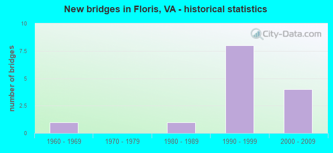
- New bridges - historical statistics
- 11960-1969
- 11980-1989
- 81990-1999
- 42000-2009


- Bridge Condition - Deck
- 80.0%Good
- 20.0%Satisfactory

- Bridge Condition - Superstructure
- 20.0%Very good
- 80.0%Good

- Bridge Condition - Substructure
- 60.0%Good
- 20.0%Satisfactory
- 20.0%Fair

- Bridge Condition - Channel
- 12.5%Very good
- 37.5%Good
- 37.5%Satisfactory
- 12.5%Fair

- Bridge Condition - Culverts
- 60.0%Good
- 20.0%Satisfactory
- 20.0%Fair
Find on map >> Show street view
Structure Number: 6255, Location: 01.00FR668/00.15TO608 (Lat: 38.946456, Lng: -77.429778), Route carried "on" structure: State highway 28, Year Built: 1988, Status: Open, Structure Length: 3.69m (12.11ft), Average Daily Traffic: 52,879 (year 2020), Truck Traffic: 3%, Average Future Daily Traffic: 74,031 (year 2040), Design Load: HS 20, Features Intersected: HORSEPEN RUN, Facility Carried by Structure: SULLY ROAD SBL
Minimum Vertical Clearance: 30+ m (98+ ft), Kilometerpoint: 61.464, Lanes on structure: 3, Base Highway Network: Yes, Owner: State Highway Agency, Approaching Roadway Width: 22.9m (75.1ft), Skew: 1 degrees, Material/Design: Steel continuous, Design/Construction: Stringer/Multi-beam, Number Of Spans In Main Unit: 3, Length of Maximum Span: 12.2m (40.0ft), Curb-To-Curb Width: 25.6m (84.0ft), Out-to-Out Width: 26.5m (86.9ft)
Condition: Deck: Good, Superstructure: Good, Substructure: Good, Channel: Satisfactory, Operating Rating: 80.7 metric tons, Method Used To Determine Operating Rating: Load and Resistance Factor (LRFR), Inventory Rating: 62.6 metric tons, Method Used To Determine Inventory Rating: Load and Resistance Factor (LRFR), Structural Evaluation: Better than present minimum criteria, Deck Geometry: Superior to present desirable criteria, Waterway Adequacy: Better than present minimum criteria, Approach Roadway Alignment: Equal to present desirable criteria, Length Of Structure Improvement: 1.52m (4.99ft), Designated Inspection Frequency: Every 24 months, Inspection Date: Febuary 2021, Bridge Improvement Cost: $100,000, Roadway Improvement Cost: $100,000, Total Project Cost: $210,000, Deck Structure Type: Concrete Cast-file-Place, Wearing Surface/Protective System: Deck Protection: Epoxy Coated Reinforcing
Find on map >> Show street view
Structure Number: 6262, Location: 01.00FR668/00.15TO608 (Lat: 38.946400, Lng: -77.429533), Route carried "on" structure: State highway 28, Year Built: 1961, Status: Open, Structure Length: 3.72m (12.20ft), Average Daily Traffic: 52,879 (year 2020), Truck Traffic: 3%, Average Future Daily Traffic: 74,031 (year 2040), Design Load: HS 20, Features Intersected: HORSEPEN RUN, Facility Carried by Structure: SULLY ROAD NBL
Minimum Vertical Clearance: 30+ m (98+ ft), Kilometerpoint: 61.464, Lanes on structure: 3, Base Highway Network: Yes, Owner: State Highway Agency, Approaching Roadway Width: 18.0m (59.1ft), Skew: 1 degrees, Material/Design: Steel, Design/Construction: Stringer/Multi-beam, Number Of Spans In Main Unit: 3, Length of Maximum Span: 12.8m (42.0ft), Curb-To-Curb Width: 18.0m (59.1ft), Out-to-Out Width: 18.9m (62.0ft)
Condition: Deck: Satisfactory, Superstructure: Good, Substructure: Fair, Channel: Good, Operating Rating: 95.3 metric tons, Method Used To Determine Operating Rating: Load and Resistance Factor (LRFR), Inventory Rating: 72.6 metric tons, Method Used To Determine Inventory Rating: Load and Resistance Factor (LRFR), Structural Evaluation: Somewhat better than minimum adequacy, Deck Geometry: Better than present minimum criteria, Waterway Adequacy: Better than present minimum criteria, Approach Roadway Alignment: Equal to present desirable criteria, Length Of Structure Improvement: 1.52m (4.99ft), Designated Inspection Frequency: Every 24 months, Inspection Date: Febuary 2021, Bridge Improvement Cost: $100,000, Roadway Improvement Cost: $100,000, Total Project Cost: $210,000, Deck Structure Type: Concrete Cast-file-Place, Wearing Surface/Protective System: Deck Protection: Epoxy Coated Reinforcing
Find on map >> Show street view
Structure Number: 6802, Location: 00.33 608 / 00.88 665 (Lat: 38.941606, Lng: -77.413808), Route carried "on" structure: County highway 657, Year Built: 1991, Status: Open, Structure Length: 0.82m (2.69ft), Average Daily Traffic: 21,759 (year 2020), Truck Traffic: 2%, Average Future Daily Traffic: 30,463 (year 2040), Design Load: HS 20, Features Intersected: FRYING PAN BRANCH, Facility Carried by Structure: CENTREVILLE ROAD
Minimum Vertical Clearance: 30+ m (98+ ft), Kilometerpoint: 10.539, Lanes on structure: 8, Owner: State Highway Agency, Approaching Roadway Width: 16.2m (53.1ft), Material/Design: Concrete, Design/Construction: Culvert, Number Of Spans In Main Unit: 3, Length of Maximum Span: 2.4m (7.9ft)
Condition: Channel: Satisfactory, Culverts: Fair, Operating Rating: 89.8 metric tons, Method Used To Determine Operating Rating: Load Factor (LF), Inventory Rating: 89.7 metric tons, Method Used To Determine Inventory Rating: Load Factor (LF), Structural Evaluation: Somewhat better than minimum adequacy, Waterway Adequacy: Equal to present minimum criteria, Approach Roadway Alignment: Better than present minimum criteria, Length Of Structure Improvement: 20.60m (67.59ft), Designated Inspection Frequency: Every 24 months, Inspection Date: September 2021, Bridge Improvement Cost: $15,000, Roadway Improvement Cost: $15,000, Total Project Cost: $45,000
Find on map >> Show street view
Structure Number: 6823, Location: 00.15FR6339/00.15TO6349 (Lat: 38.930325, Lng: -77.391328), Route carried "on" structure: County highway 667, Year Built: 1990, Status: Open, Structure Length: 8.75m (28.71ft), Average Daily Traffic: 3,238 (year 2016), Average Future Daily Traffic: 4,792 (year 2040), Design Load: HS 20, Features Intersected: FAIRFAX COUNTY PARKWAY, Facility Carried by Structure: PINECREST ROAD
Minimum Vertical Clearance: 30+ m (98+ ft), Kilometerpoint: 1.223, Lanes on structure: 2, Lanes under structure: 4, Owner: State Highway Agency, Approaching Roadway Width: 11.0m (36.1ft), Skew: 4 degrees, Material/Design: Steel, Design/Construction: Stringer/Multi-beam, Number Of Spans In Main Unit: 4, Length of Maximum Span: 29.3m (96.1ft), Curb or Sidewalk Widths: Left: 1.8m (5.9ft), Right: 1.8m (5.9ft), Curb-To-Curb Width: 11.0m (36.1ft), Out-to-Out Width: 15.2m (49.9ft)
Condition: Deck: Good, Superstructure: Good, Substructure: Satisfactory, Operating Rating: 87.1 metric tons, Method Used To Determine Operating Rating: Load and Resistance Factor (LRFR), Inventory Rating: 67.1 metric tons, Method Used To Determine Inventory Rating: Load and Resistance Factor (LRFR), Structural Evaluation: Equal to present minimum criteria, Deck Geometry: Somewhat better than minimum adequacy, Underclear: Better than present minimum criteria, Approach Roadway Alignment: Equal to present desirable criteria, Length Of Structure Improvement: 8.75m (28.71ft), Designated Inspection Frequency: Every 24 months, Inspection Date: September 2020, Bridge Improvement Cost: $54,000, Roadway Improvement Cost: $74,000, Total Project Cost: $150,000 ( Estimate for 2014), Deck Structure Type: Concrete Cast-file-Place, Wearing Surface/Protective System: Deck Protection: Epoxy Coated Reinforcing
Find on map >> Show street view
Structure Number: 23713, Location: 00.40FR665/00.01TO7498 (Lat: 38.938100, Lng: -77.394900), Route carried "on" structure: County highway 666, Year Built: 1993, Status: Open, Structure Length: 0.88m (2.89ft), Average Daily Traffic: 4,927 (year 2020), Truck Traffic: 1%, Average Future Daily Traffic: 6,898 (year 2040), Design Load: HS 20+Mod, Features Intersected: TRIB. FRYING PAN BRANCH, Facility Carried by Structure: MONROE STREET
Minimum Vertical Clearance: 30+ m (98+ ft), Kilometerpoint: 1.046, Lanes on structure: 6, Owner: State Highway Agency, Approaching Roadway Width: 23.8m (78.1ft), Material/Design: Concrete, Design/Construction: Culvert, Number Of Spans In Main Unit: 5, Length of Maximum Span: 1.5m (4.9ft)
Condition: Channel: Satisfactory, Culverts: Good, Operating Rating: 89.8 metric tons, Method Used To Determine Operating Rating: Load Factor (LF), Inventory Rating: 80.7 metric tons, Method Used To Determine Inventory Rating: Load Factor (LF), Structural Evaluation: Better than present minimum criteria, Waterway Adequacy: Equal to present minimum criteria, Approach Roadway Alignment: Better than present minimum criteria, Length Of Structure Improvement: 16.76m (54.99ft), Designated Inspection Frequency: Every 24 months, Inspection Date: August 2021, Bridge Improvement Cost: $12,000, Roadway Improvement Cost: $12,000, Total Project Cost: $30,000
Find on map >> Show street view
Structure Number: 23714, Location: 00.10FR666/00.05TO00000 (Lat: 38.940431, Lng: -77.396539), Route carried "on" structure: Alternate County highway 7712, Year Built: 1993, Status: Open, Structure Length: 1.58m (5.18ft), Average Daily Traffic: 213 (year 2015), Average Future Daily Traffic: 240 (year 2040), Design Load: HS 20+Mod, Features Intersected: TRIB. FRYING PAN BRANCH, Facility Carried by Structure: CEDAR GLEN LANE
Minimum Vertical Clearance: 30+ m (98+ ft), Kilometerpoint: 0.161, Lanes on structure: 2, Owner: State Highway Agency, Approaching Roadway Width: 10.4m (34.1ft), Skew: 3 degrees, Material/Design: Concrete, Design/Construction: Culvert, Number Of Spans In Main Unit: 8, Length of Maximum Span: 1.8m (5.9ft)
Condition: Channel: Good, Culverts: Good, Operating Rating: 89.8 metric tons, Method Used To Determine Operating Rating: Load Factor (LF), Inventory Rating: 80.7 metric tons, Method Used To Determine Inventory Rating: Load Factor (LF), Structural Evaluation: Better than present minimum criteria, Waterway Adequacy: Equal to present minimum criteria, Approach Roadway Alignment: Equal to present desirable criteria, Length Of Structure Improvement: 19.51m (64.01ft), Designated Inspection Frequency: Every 24 months, Inspection Date: August 2021, Bridge Improvement Cost: $54,000, Roadway Improvement Cost: $79,000, Total Project Cost: $150,000
Find on map >> Show street view
Structure Number: 24044, Location: 00.30FR286/00.65TO666 (Lat: 38.924186, Lng: -77.399281), Route carried "on" structure: County highway 608, Year Built: 1994, Status: Open, Structure Length: 1.34m (4.40ft), Average Daily Traffic: 14,465 (year 2020), Truck Traffic: 2%, Average Future Daily Traffic: 20,251 (year 2040), Design Load: HS 20+Mod, Features Intersected: BRANCH OF HORSEPEN RUN, Facility Carried by Structure: WEST OX ROAD
Minimum Vertical Clearance: 30+ m (98+ ft), Kilometerpoint: 10.330, Lanes on structure: 2, Owner: State Highway Agency, Approaching Roadway Width: 7.6m (24.9ft), Skew: 2 degrees, Material/Design: Concrete, Design/Construction: Culvert, Number Of Spans In Main Unit: 4, Length of Maximum Span: 3.0m (9.8ft), Curb or Sidewalk Widths: Left: 2.4m (7.9ft), Right: 0.0m
Condition: Channel: Good, Culverts: Satisfactory, Operating Rating: 89.8 metric tons, Method Used To Determine Operating Rating: Load Factor (LF), Inventory Rating: 89.8 metric tons, Method Used To Determine Inventory Rating: Load Factor (LF), Structural Evaluation: Equal to present minimum criteria, Waterway Adequacy: Equal to present desirable criteria, Approach Roadway Alignment: Equal to present desirable criteria, Length Of Structure Improvement: 18.29m (60.01ft), Designated Inspection Frequency: Every 24 months, Inspection Date: March 2021, Bridge Improvement Cost: $39,000, Roadway Improvement Cost: $69,000, Total Project Cost: $150,000
Find on map >> Show street view
Structure Number: 24727, Location: 00.10FR8190/00.40TO668 (Lat: 38.928797, Lng: -77.415064), Route carried "on" structure: County highway 657, Year Built: 1994, Status: Open, Structure Length: 1.37m (4.49ft), Average Daily Traffic: 15,704 (year 2020), Truck Traffic: 2%, Average Future Daily Traffic: 17,274 (year 2040), Design Load: HS 20, Features Intersected: HORSEPEN RUN, Facility Carried by Structure: CENTREVILLE RD.
Minimum Vertical Clearance: 30+ m (98+ ft), Kilometerpoint: 9.557, Lanes on structure: 4, Owner: State Highway Agency, Approaching Roadway Width: 8.5m (27.9ft), Skew: 23 degrees, Material/Design: Steel, Design/Construction: Culvert, Number Of Spans In Main Unit: 4, Length of Maximum Span: 4.9m (16.1ft), Curb or Sidewalk Widths: Left: 2.4m (7.9ft), Right: 1.5m (4.9ft)
Condition: Channel: Fair, Culverts: Good, Operating Rating: 73.5 metric tons, Method Used To Determine Operating Rating: Load Factor (LF), Inventory Rating: 43.5 metric tons, Method Used To Determine Inventory Rating: Load Factor (LF), Structural Evaluation: Better than present minimum criteria, Waterway Adequacy: Equal to present desirable criteria, Approach Roadway Alignment: Equal to present desirable criteria, Length Of Structure Improvement: 0.46m (1.51ft), Designated Inspection Frequency: Every 24 months, Inspection Date: March 2021, Bridge Improvement Cost: $1,000, Roadway Improvement Cost: $1,000, Total Project Cost: $3,000 ( Estimate for 2015)
Find on map >> Show street view
Structure Number: 28269, Location: 2.15 FR607/1.02 TO 608 (Lat: 38.930492, Lng: -77.429261), Route carried "on" structure: County highway 668, Year Built: 2006, Status: Open, Structure Length: 8.69m (28.51ft), Average Daily Traffic: 17,436 (year 2018), Truck Traffic: 3%, Average Future Daily Traffic: 27,611 (year 2035), Design Load: HS 20+Mod, Features Intersected: RTE.28 SULLY RD., Facility Carried by Structure: MCLEAREN ROAD
Minimum Vertical Clearance: 30+ m (98+ ft), Kilometerpoint: 0.000, Lanes on structure: 2, Lanes under structure: 7, Owner: State Highway Agency, Approaching Roadway Width: 7.3m (24.0ft), Skew: 20 degrees, Material/Design: Steel, Design/Construction: Stringer/Multi-beam, Number Of Spans In Main Unit: 3, Length of Maximum Span: 33.5m (109.9ft), Curb-To-Curb Width: 19.5m (64.0ft), Out-to-Out Width: 20.4m (66.9ft)
Condition: Deck: Good, Superstructure: Good, Substructure: Good, Operating Rating: 54.4 metric tons, Method Used To Determine Operating Rating: Load and Resistance Factor (LRFR), Inventory Rating: 41.7 metric tons, Method Used To Determine Inventory Rating: Load and Resistance Factor (LRFR), Structural Evaluation: Better than present minimum criteria, Deck Geometry: Superior to present desirable criteria, Underclear: Superior to present desirable criteria, Approach Roadway Alignment: Equal to present desirable criteria, Length Of Structure Improvement: 8.69m (28.51ft), Designated Inspection Frequency: Every 24 months, Inspection Date: April 2020, Bridge Improvement Cost: $61,000, Roadway Improvement Cost: $99,000, Total Project Cost: $200,000 ( Estimate for 2014), Deck Structure Type: Concrete Cast-file-Place, Wearing Surface/Protective System: Wearing Surface: Monolithic Concrete, Deck Protection: Epoxy Coated Reinforcing
Find on map >> Show street view
Structure Number: 28503, Location: 00.30From28/00.90To657 (Lat: 38.946322, Lng: -77.429161), Route carried "on" structure: Ramp State highway 28, Year Built: 2009, Status: Open, Structure Length: 5.09m (16.70ft), Average Daily Traffic: 1,400 (year 2009), Average Future Daily Traffic: 5,000 (year 2031), Design Load: HS 20, Features Intersected: HORSEPEN RUN
Minimum Vertical Clearance: 30.45m (99.90ft), Kilometerpoint: 0.000, Lanes on structure: 1, Owner: State Highway Agency, Approaching Roadway Width: 10.7m (35.1ft), Skew: 1 degrees, Material/Design: Steel continuous, Design/Construction: Stringer/Multi-beam, Number Of Spans In Main Unit: 2, Length of Maximum Span: 25.0m (82.0ft), Curb-To-Curb Width: 7.9m (25.9ft), Out-to-Out Width: 12.2m (40.0ft)
Condition: Deck: Good, Superstructure: Very good, Substructure: Good, Channel: Very good, Operating Rating: 66.2 metric tons, Method Used To Determine Operating Rating: Load and Resistance Factor (LRFR), Inventory Rating: 50.8 metric tons, Method Used To Determine Inventory Rating: Load and Resistance Factor (LRFR), Structural Evaluation: Better than present minimum criteria, Deck Geometry: Equal to present desirable criteria, Approach Roadway Alignment: Equal to present desirable criteria, Length Of Structure Improvement: 0.30m (0.98ft), Designated Inspection Frequency: Every 24 months, Inspection Date: October 2021, Total Project Cost: $5,000, Deck Structure Type: Concrete Cast-file-Place, Wearing Surface/Protective System: Wearing Surface: Monolithic Concrete, Deck Protection: Epoxy Coated Reinforcing
Find on map >> Show street view
Structure Number: 6823, Location: 00.15FR6339/00.15TO6349 (Lat: 38.930325, Lng: -77.391328), Route carried "under" structure: County highway 286, Year Built: 1990, Structure Length: 0. m, Average Daily Traffic: 45,451 (year 2008), Truck Traffic: 1%, Features Intersected: FAIRFAX COUNTY PARKWAY, Facility Carried by Structure: PINECREST ROAD
Minimum Vertical Clearance: 5.84m (19.16ft), Kilometerpoint: 9.831, Lanes on structure: 2, Lanes under structure: 2, Material/Design: Steel, Design/Construction: Stringer/Multi-beam, Length of Maximum Span: 29.3m (96.1ft)
Find on map >> Show street view
Structure Number: 6823, Location: 00.15FR6339/00.15TO6349 (Lat: 38.930325, Lng: -77.391328), Route carried "under" structure: Bypass County highway 286, Year Built: 1990, Structure Length: 0. m, Average Daily Traffic: 45,451 (year 2008), Truck Traffic: 1%, Features Intersected: FAIRFAX COUNTY PARKWAY, Facility Carried by Structure: PINECREST ROAD
Minimum Vertical Clearance: 5.21m (17.09ft), Kilometerpoint: 9.831, Lanes on structure: 2, Lanes under structure: 2, Material/Design: Steel, Design/Construction: Stringer/Multi-beam, Length of Maximum Span: 29.3m (96.1ft)
Find on map >> Show street view
Structure Number: 28269, Location: 2.15 FR607/1.02 TO 608 (Lat: 38.930492, Lng: -77.429261), Route carried "under" structure: State highway 28, Year Built: 2006, Structure Length: 0. m, Average Daily Traffic: 40,000 (year 2006), Truck Traffic: 10%, Features Intersected: RTE.28 SULLY RD., Facility Carried by Structure: MCLEAREN ROAD
Minimum Vertical Clearance: 5.33m (17.49ft), Kilometerpoint: 0.000, Lanes on structure: 2, Lanes under structure: 4, Material/Design: Steel, Design/Construction: Stringer/Multi-beam, Length of Maximum Span: 33.5m (109.9ft)
Find on map >> Show street view
Structure Number: 28269, Location: 2.15 FR607/1.02 TO 608 (Lat: 38.930492, Lng: -77.429261), Route carried "under" structure: State highway 28, Year Built: 2006, Structure Length: 0. m, Average Daily Traffic: 40,000 (year 2006), Truck Traffic: 10%, Features Intersected: RTE.28 SULLY RD., Facility Carried by Structure: MCLEAREN ROAD
Minimum Vertical Clearance: 5.43m (17.81ft), Kilometerpoint: 0.000, Lanes on structure: 2, Lanes under structure: 3, Material/Design: Steel, Design/Construction: Stringer/Multi-beam, Length of Maximum Span: 33.5m (109.9ft)