Bridge Statistics for Henderson, Texas (TX)
Condition, Traffic, Stress, Structural Evaluation, Project Costs
- National Bridge Inventory (NBI) Statistics
- 43Number of bridges
- 285ft / 87.2mTotal length
- $258,000Total costs
- 139,330Total average daily traffic
- 15,848Total average daily truck traffic
- National Bridge Inventory (NBI) Registered Bridges for Henderson
- No street view available for this location
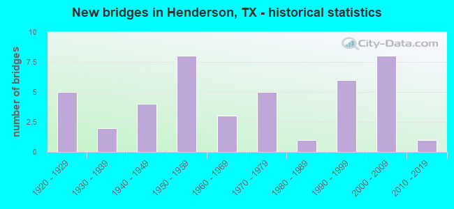
- New bridges - historical statistics
- 51920-1929
- 21930-1939
- 41940-1949
- 81950-1959
- 31960-1969
- 51970-1979
- 11980-1989
- 61990-1999
- 82000-2009
- 12010-2019

- Reconstructed bridges - Historical Statistics
- 11930-1939
- 01940-1949
- 31950-1959
- 21960-1969
- 41970-1979
- 31980-1989
- 11990-1999
- 12000-2009
- 12010-2019


- Bridge Condition - Deck
- 6.3%Very good
- 75.0%Good
- 18.8%Satisfactory

- Bridge Condition - Superstructure
- 12.5%Very good
- 68.8%Good
- 18.8%Satisfactory

- Bridge Condition - Substructure
- 50.0%Good
- 37.5%Satisfactory
- 6.3%Fair
- 6.3%Serious

- Bridge Condition - Channel
- 2.7%Very good
- 10.8%Good
- 78.4%Satisfactory
- 8.1%Fair

- Bridge Condition - Culverts
- 12.5%Good
- 79.2%Satisfactory
- 8.3%Fair
Find on map >> Show street view
Structure Number: 102010013803043, Location: 0.95 MI NW OF LP 571 (Lat: 32.203578, Lng: -94.823031), Route carried "on" structure: US 259, Year Built: 1941, Year Reconstructed: 1970, Status: Open, Structure Length: 0.76m (2.49ft), Average Daily Traffic: 9,837 (year 2020), Truck Traffic: 13%, Average Future Daily Traffic: 17,140 (year 2033), Features Intersected: GRIST CREEK
Minimum Vertical Clearance: 30+ m (98+ ft), Kilometerpoint: 8.605, Lanes on structure: 4, Owner: State Highway Agency, Approaching Roadway Width: 25.9m (85.0ft), Skew: 13 degrees, Material/Design: Concrete, Design/Construction: Culvert, Number Of Spans In Main Unit: 2, Length of Maximum Span: 3.0m (9.8ft)
Condition: Channel: Satisfactory, Culverts: Satisfactory, Operating Rating: 32.7 metric tons, Method Used To Determine Operating Rating: Field evaluation and documented engineering judgment, Inventory Rating: 24.5 metric tons, Method Used To Determine Inventory Rating: Field evaluation and documented engineering judgment, Structural Evaluation: Equal to present minimum criteria, Waterway Adequacy: Equal to present minimum criteria, Approach Roadway Alignment: Equal to present desirable criteria, Length Of Structure Improvement: 0.76m (2.49ft), Designated Inspection Frequency: Every 24 months, Inspection Date: May 2021, Bridge Improvement Cost: $30,000, Roadway Improvement Cost: $10,000, Total Project Cost: $40,000
Find on map >> Show street view
Structure Number: 102010013804044, Location: 0.1 MI S OF US 79 (Lat: 32.144186, Lng: -94.790061), Route carried "on" structure: US 259, Year Built: 1942, Year Reconstructed: 1976, Status: Open, Structure Length: 1.89m (6.20ft), Average Daily Traffic: 8,597 (year 2018), Truck Traffic: 15%, Average Future Daily Traffic: 15,680 (year 2033), Features Intersected: SHAWNEE CREEK
Minimum Vertical Clearance: 30+ m (98+ ft), Kilometerpoint: 1.757, Lanes on structure: 6, Owner: State Highway Agency, Approaching Roadway Width: 25.6m (84.0ft), Skew: 4 degrees, Material/Design: Concrete, Design/Construction: Culvert, Number Of Spans In Main Unit: 4, Length of Maximum Span: 3.0m (9.8ft), Curb-To-Curb Width: 25.6m (84.0ft), Out-to-Out Width: 44.6m (146.3ft)
Condition: Channel: Satisfactory, Culverts: Satisfactory, Operating Rating: 32.7 metric tons, Method Used To Determine Operating Rating: Field evaluation and documented engineering judgment, Inventory Rating: 24.5 metric tons, Method Used To Determine Inventory Rating: Field evaluation and documented engineering judgment, Structural Evaluation: Equal to present minimum criteria, Deck Geometry: Somewhat better than minimum adequacy, Waterway Adequacy: Equal to present minimum criteria, Approach Roadway Alignment: Equal to present desirable criteria, Length Of Structure Improvement: 1.52m (4.99ft), Designated Inspection Frequency: Every 24 months, Inspection Date: May 2021, Bridge Improvement Cost: $15,000, Roadway Improvement Cost: $4,000, Total Project Cost: $19,000, Deck Structure Type: Concrete Cast-file-Place, Wearing Surface/Protective System: Wearing Surface: Bituminous
Find on map >> Show street view
Structure Number: 102010013804045, Location: 0.4 MI SE OF US 79 (Lat: 32.139589, Lng: -94.787522), Route carried "on" structure: US 259, Year Built: 1942, Year Reconstructed: 1976, Status: Open, Structure Length: 0.98m (3.22ft), Average Daily Traffic: 8,597 (year 2018), Truck Traffic: 15%, Average Future Daily Traffic: 15,680 (year 2033), Features Intersected: DUTCH CREEK
Minimum Vertical Clearance: 30+ m (98+ ft), Kilometerpoint: 2.306, Lanes on structure: 4, Owner: State Highway Agency, Approaching Roadway Width: 19.5m (64.0ft), Skew: 9 degrees, Material/Design: Concrete, Design/Construction: Culvert, Number Of Spans In Main Unit: 4, Length of Maximum Span: 2.1m (6.9ft)
Condition: Channel: Satisfactory, Culverts: Satisfactory, Operating Rating: 32.7 metric tons, Method Used To Determine Operating Rating: Field evaluation and documented engineering judgment, Inventory Rating: 24.5 metric tons, Method Used To Determine Inventory Rating: Field evaluation and documented engineering judgment, Structural Evaluation: Equal to present minimum criteria, Waterway Adequacy: Equal to present minimum criteria, Approach Roadway Alignment: Equal to present desirable criteria, Designated Inspection Frequency: Every 24 months, Inspection Date: May 2021
Find on map >> Show street view
Structure Number: 102010013809089, Location: 0.6 MI S OF US 79 (Lat: 32.129297, Lng: -94.795189), Route carried "on" structure: State highway 3310, Year Built: 1922, Year Reconstructed: 1950, Status: Open, Structure Length: 1.16m (3.81ft), Average Daily Traffic: 2,905 (year 2020), Truck Traffic: 7%, Average Future Daily Traffic: 3,370 (year 2039), Features Intersected: SHAWNEE CR
Minimum Vertical Clearance: 30+ m (98+ ft), Kilometerpoint: 2.567, Lanes on structure: 2, Owner: State Highway Agency, Approaching Roadway Width: 7.6m (24.9ft), Material/Design: Concrete, Design/Construction: Slab, Number Of Spans In Main Unit: 2, Length of Maximum Span: 5.8m (19.0ft), Curb-To-Curb Width: 11.6m (38.1ft), Out-to-Out Width: 12.3m (40.4ft)
Condition: Deck: Satisfactory, Superstructure: Satisfactory, Substructure: Serious, Channel: Satisfactory, Operating Rating: 32.7 metric tons, Method Used To Determine Operating Rating: Field evaluation and documented engineering judgment, Inventory Rating: 24.5 metric tons, Method Used To Determine Inventory Rating: Field evaluation and documented engineering judgment, Structural Evaluation: High priority of corrective action, Deck Geometry: Somewhat better than minimum adequacy, Waterway Adequacy: Equal to present minimum criteria, Approach Roadway Alignment: Better than present minimum criteria, Length Of Structure Improvement: 1.28m (4.20ft), Designated Inspection Frequency: Every 24 months, Inspection Date: May 2021, Bridge Improvement Cost: $67,000, Roadway Improvement Cost: $32,000, Total Project Cost: $99,000, Deck Structure Type: Concrete Cast-file-Place, Wearing Surface/Protective System: Wearing Surface: Bituminous
Find on map >> Show street view
Structure Number: 10201001380909, Location: 1.2 MI S OF US 79 (Lat: 32.125222, Lng: -94.785267), Route carried "on" structure: State highway 3310, Year Built: 1930, Year Reconstructed: 1950, Status: Open, Structure Length: 1.10m (3.61ft), Average Daily Traffic: 2,905 (year 2020), Truck Traffic: 7%, Average Future Daily Traffic: 3,370 (year 2039), Features Intersected: DUTCH BRANCH
Minimum Vertical Clearance: 30+ m (98+ ft), Kilometerpoint: 3.637, Lanes on structure: 2, Owner: State Highway Agency, Approaching Roadway Width: 7.6m (24.9ft), Skew: 1 degrees, Material/Design: Concrete, Design/Construction: Culvert, Number Of Spans In Main Unit: 3, Length of Maximum Span: 3.0m (9.8ft), Curb-To-Curb Width: 13.2m (43.3ft), Out-to-Out Width: 14.0m (45.9ft)
Condition: Channel: Satisfactory, Culverts: Satisfactory, Operating Rating: 39.9 metric tons, Method Used To Determine Operating Rating: Load Factor (LF), Inventory Rating: 23.6 metric tons, Method Used To Determine Inventory Rating: Load Factor (LF), Structural Evaluation: Equal to present minimum criteria, Deck Geometry: Equal to present minimum criteria, Waterway Adequacy: Equal to present minimum criteria, Approach Roadway Alignment: Equal to present desirable criteria, Length Of Structure Improvement: 1.04m (3.41ft), Designated Inspection Frequency: Every 24 months, Inspection Date: May 2021, Deck Structure Type: Concrete Cast-file-Place, Wearing Surface/Protective System: Wearing Surface: Bituminous
Find on map >> Show street view
Structure Number: 102010020607026, Location: 0.5 MI NE OF FM 839 (Lat: 32.099078, Lng: -94.864978), Route carried "on" structure: US 79, Year Built: 1950, Year Reconstructed: 2016, Status: Open, Structure Length: 1.07m (3.51ft), Average Daily Traffic: 5,528 (year 2020), Truck Traffic: 22%, Average Future Daily Traffic: 9,860 (year 2039), Design Load: H 15, Features Intersected: PARKER CREEK
Minimum Vertical Clearance: 30+ m (98+ ft), Kilometerpoint: 13.065, Lanes on structure: 3, Owner: State Highway Agency, Approaching Roadway Width: 17.7m (58.1ft), Material/Design: Concrete, Design/Construction: Culvert, Number Of Spans In Main Unit: 4, Length of Maximum Span: 2.4m (7.9ft)
Condition: Channel: Fair, Culverts: Satisfactory, Operating Rating: 39.9 metric tons, Method Used To Determine Operating Rating: Load Factor (LF), Inventory Rating: 23.6 metric tons, Method Used To Determine Inventory Rating: Load Factor (LF), Structural Evaluation: Somewhat better than minimum adequacy, Waterway Adequacy: Equal to present minimum criteria, Approach Roadway Alignment: Equal to present desirable criteria, Designated Inspection Frequency: Every 24 months, Inspection Date: May 2021
Find on map >> Show street view
Structure Number: 102010020607027, Location: 0.8 MI SW OF LP 571 (Lat: 32.113511, Lng: -94.839225), Route carried "on" structure: US 79, Year Built: 1950, Status: Open, Structure Length: 5.49m (18.01ft), Average Daily Traffic: 8,025 (year 2019), Truck Traffic: 15%, Average Future Daily Traffic: 12,320 (year 2039), Design Load: H 20, Features Intersected: TURKEY CREEK
Minimum Vertical Clearance: 30+ m (98+ ft), Kilometerpoint: 10.108, Lanes on structure: 2, Owner: State Highway Agency, Approaching Roadway Width: 17.7m (58.1ft), Material/Design: Concrete continuous, Design/Construction: Slab, Number Of Spans In Main Unit: 7, Length of Maximum Span: 9.1m (29.9ft), Curb-To-Curb Width: 12.2m (40.0ft), Out-to-Out Width: 12.8m (42.0ft)
Condition: Deck: Good, Superstructure: Good, Substructure: Satisfactory, Channel: Satisfactory, Operating Rating: 47.2 metric tons, Method Used To Determine Operating Rating: Load Factor (LF), Inventory Rating: 28.1 metric tons, Method Used To Determine Inventory Rating: Load Factor (LF), Structural Evaluation: Equal to present minimum criteria, Deck Geometry: Somewhat better than minimum adequacy, Waterway Adequacy: Equal to present minimum criteria, Approach Roadway Alignment: Equal to present desirable criteria, Designated Inspection Frequency: Every 24 months, Inspection Date: May 2021, Deck Structure Type: Concrete Cast-file-Place, Wearing Surface/Protective System: Wearing Surface: Bituminous
Find on map >> Show street view
Structure Number: 102010020607028, Location: 0.35 MI NE OF LP 571 (Lat: 32.123094, Lng: -94.821192), Route carried "on" structure: US 79, Year Built: 1950, Year Reconstructed: 1985, Status: Open, Structure Length: 0.70m (2.30ft), Average Daily Traffic: 8,025 (year 2019), Truck Traffic: 15%, Average Future Daily Traffic: 12,320 (year 2039), Design Load: H 15, Features Intersected: Bromley Cr Tr
Minimum Vertical Clearance: 30+ m (98+ ft), Kilometerpoint: 8.148, Lanes on structure: 5, Owner: State Highway Agency, Approaching Roadway Width: 20.7m (67.9ft), Material/Design: Concrete, Design/Construction: Culvert, Number Of Spans In Main Unit: 3, Length of Maximum Span: 2.1m (6.9ft)
Condition: Channel: Good, Culverts: Satisfactory, Operating Rating: 39.9 metric tons, Method Used To Determine Operating Rating: Load Factor (LF), Inventory Rating: 23.6 metric tons, Method Used To Determine Inventory Rating: Load Factor (LF), Structural Evaluation: Somewhat better than minimum adequacy, Waterway Adequacy: Equal to present minimum criteria, Approach Roadway Alignment: Equal to present desirable criteria, Designated Inspection Frequency: Every 24 months, Inspection Date: May 2021
Find on map >> Show street view
Structure Number: 102010020607029, Location: 2.2 MI SW OF US 259 (Lat: 32.123936, Lng: -94.819711), Route carried "on" structure: US 79, Year Built: 1950, Year Reconstructed: 1985, Status: Open, Structure Length: 7.62m (25.00ft), Average Daily Traffic: 7,255 (year 2020), Truck Traffic: 15%, Average Future Daily Traffic: 12,320 (year 2039), Design Load: H 20, Features Intersected: BROMLEY CREEK
Minimum Vertical Clearance: 30+ m (98+ ft), Kilometerpoint: 7.910, Lanes on structure: 5, Owner: State Highway Agency, Approaching Roadway Width: 20.7m (67.9ft), Material/Design: Concrete continuous, Design/Construction: Slab, Number Of Spans In Main Unit: 10, Length of Maximum Span: 7.6m (24.9ft), Curb or Sidewalk Widths: Left: 1.2m (3.9ft), Right: 1.2m (3.9ft), Curb-To-Curb Width: 20.8m (68.2ft), Out-to-Out Width: 24.6m (80.7ft)
Condition: Deck: Satisfactory, Superstructure: Satisfactory, Substructure: Satisfactory, Channel: Satisfactory, Operating Rating: 37.2 metric tons, Method Used To Determine Operating Rating: Load Factor (LF), Inventory Rating: 28.1 metric tons, Method Used To Determine Inventory Rating: Load Factor (LF), Structural Evaluation: Equal to present minimum criteria, Deck Geometry: Somewhat better than minimum adequacy, Waterway Adequacy: Superior to present desirable criteria, Approach Roadway Alignment: Equal to present desirable criteria, Designated Inspection Frequency: Every 24 months, Inspection Date: May 2021, Deck Structure Type: Concrete Cast-file-Place, Wearing Surface/Protective System: Wearing Surface: Bituminous
Find on map >> Show street view
Structure Number: 10201002060703, Location: 0.70 MI NE OF LP 571 (Lat: 32.125317, Lng: -94.817111), Route carried "on" structure: US 79, Year Built: 1950, Year Reconstructed: 1985, Status: Open, Structure Length: 0.70m (2.30ft), Average Daily Traffic: 8,025 (year 2019), Truck Traffic: 15%, Average Future Daily Traffic: 12,320 (year 2039), Design Load: H 15, Features Intersected: BROMLEY CREEK RELIEF
Minimum Vertical Clearance: 30+ m (98+ ft), Kilometerpoint: 7.689, Lanes on structure: 5, Owner: State Highway Agency, Approaching Roadway Width: 20.7m (67.9ft), Material/Design: Concrete, Design/Construction: Culvert, Number Of Spans In Main Unit: 3, Length of Maximum Span: 2.1m (6.9ft)
Condition: Channel: Good, Culverts: Satisfactory, Operating Rating: 39.9 metric tons, Method Used To Determine Operating Rating: Load Factor (LF), Inventory Rating: 23.6 metric tons, Method Used To Determine Inventory Rating: Load Factor (LF), Structural Evaluation: Somewhat better than minimum adequacy, Waterway Adequacy: Equal to present minimum criteria, Approach Roadway Alignment: Equal to present desirable criteria, Designated Inspection Frequency: Every 24 months, Inspection Date: May 2021
Find on map >> Show street view
Structure Number: 102010024508031, Location: 1.7 MI W OF LP 571 (Lat: 32.167614, Lng: -94.860081), Route carried "on" structure: State highway 64, Year Built: 1940, Year Reconstructed: 1960, Status: Open, Structure Length: 3.20m (10.50ft), Average Daily Traffic: 5,667 (year 2020), Truck Traffic: 9%, Average Future Daily Traffic: 8,130 (year 2033), Design Load: H 15, Features Intersected: BROMLEY CREEK
Minimum Vertical Clearance: 30+ m (98+ ft), Kilometerpoint: 12.527, Lanes on structure: 2, Owner: State Highway Agency, Approaching Roadway Width: 13.4m (44.0ft), Material/Design: Steel, Design/Construction: Stringer/Multi-beam, Number Of Spans In Main Unit: 3, Length of Maximum Span: 10.7m (35.1ft), Curb-To-Curb Width: 12.2m (40.0ft), Out-to-Out Width: 13.5m (44.3ft)
Condition: Deck: Satisfactory, Superstructure: Satisfactory, Substructure: Good, Channel: Satisfactory, Operating Rating: 47.2 metric tons, Method Used To Determine Operating Rating: Load Factor (LF), Inventory Rating: 28.1 metric tons, Method Used To Determine Inventory Rating: Load Factor (LF), Structural Evaluation: Equal to present minimum criteria, Deck Geometry: Somewhat better than minimum adequacy, Waterway Adequacy: Equal to present minimum criteria, Approach Roadway Alignment: Equal to present desirable criteria, Designated Inspection Frequency: Every 24 months, Inspection Date: May 2021, Deck Structure Type: Concrete Cast-file-Place, Wearing Surface/Protective System: Wearing Surface: Bituminous
Find on map >> Show street view
Structure Number: 102010024508039, Location: 0.7 MI SW OF SH 323 (Lat: 32.167839, Lng: -94.831286), Route carried "on" structure: State highway 571, Year Built: 2000, Status: Open, Structure Length: 7.89m (25.89ft), Average Daily Traffic: 3,050 (year 2013), Truck Traffic: 12%, Average Future Daily Traffic: 4,270 (year 2033), Design Load: HS 20, Features Intersected: SH 64
Minimum Vertical Clearance: 30+ m (98+ ft), Kilometerpoint: 16.066, Lanes on structure: 2, Lanes under structure: 5, Owner: State Highway Agency, Approaching Roadway Width: 13.4m (44.0ft), Skew: 2 degrees, Material/Design: Prestressed concrete, Design/Construction: Stringer/Multi-beam, Number Of Spans In Main Unit: 1, Number Of Approach Spans: 2, Length of Maximum Span: 32.3m (106.0ft), Curb-To-Curb Width: 13.2m (43.3ft), Out-to-Out Width: 14.0m (45.9ft)
Condition: Deck: Good, Superstructure: Very good, Substructure: Good, Operating Rating: 54.4 metric tons, Method Used To Determine Operating Rating: Assigned rating based on Load Factor Design (LFD) reported in metric tons, Inventory Rating: 32.7 metric tons, Method Used To Determine Inventory Rating: Assigned rating based on Load Factor Design (LFD) reported in metric tons, Structural Evaluation: Better than present minimum criteria, Deck Geometry: Equal to present minimum criteria, Underclear: Equal to present minimum criteria, Approach Roadway Alignment: Equal to present desirable criteria, Designated Inspection Frequency: Every 24 months, Inspection Date: May 2021, Deck Structure Type: Concrete Precast Panels, Wearing Surface/Protective System: Wearing Surface: Monolithic Concrete
Find on map >> Show street view
Structure Number: 102010059102003, Location: 1.7 MI E OF LOOP 571 (Lat: 32.151875, Lng: -94.810781), Route carried "on" structure: State highway 13, Year Built: 1924, Year Reconstructed: 1942, Status: Open, Structure Length: 1.07m (3.51ft), Average Daily Traffic: 5,307 (year 2020), Truck Traffic: 5%, Average Future Daily Traffic: 6,990 (year 2033), Features Intersected: HARDY CREEK
Minimum Vertical Clearance: 30+ m (98+ ft), Kilometerpoint: 17.848, Lanes on structure: 2, Owner: State Highway Agency, Approaching Roadway Width: 12.2m (40.0ft), Material/Design: Concrete, Design/Construction: Culvert, Number Of Spans In Main Unit: 3, Length of Maximum Span: 3.0m (9.8ft), Curb-To-Curb Width: 13.1m (43.0ft), Out-to-Out Width: 15.5m (50.9ft)
Condition: Channel: Satisfactory, Culverts: Satisfactory, Operating Rating: 39.9 metric tons, Method Used To Determine Operating Rating: Load Factor (LF), Inventory Rating: 23.6 metric tons, Method Used To Determine Inventory Rating: Load Factor (LF), Structural Evaluation: Somewhat better than minimum adequacy, Deck Geometry: Somewhat better than minimum adequacy, Waterway Adequacy: Equal to present minimum criteria, Approach Roadway Alignment: Equal to present desirable criteria, Designated Inspection Frequency: Every 24 months, Inspection Date: May 2021, Deck Structure Type: Concrete Cast-file-Place, Wearing Surface/Protective System: Wearing Surface: Bituminous
Find on map >> Show street view
Structure Number: 102010059102009, Location: 0.05 MI W OF LP 571 (Lat: 32.150536, Lng: -94.840867), Route carried "on" structure: State highway 13, Year Built: 1959, Status: Open, Structure Length: 1.34m (4.40ft), Average Daily Traffic: 2,768 (year 2020), Truck Traffic: 3%, Average Future Daily Traffic: 3,830 (year 2039), Features Intersected: BROMLEY CREEK
Minimum Vertical Clearance: 30+ m (98+ ft), Kilometerpoint: 14.972, Lanes on structure: 2, Owner: State Highway Agency, Approaching Roadway Width: 7.6m (24.9ft), Material/Design: Concrete, Design/Construction: Culvert, Number Of Spans In Main Unit: 4, Length of Maximum Span: 3.0m (9.8ft)
Condition: Channel: Satisfactory, Culverts: Satisfactory, Operating Rating: 32.7 metric tons, Method Used To Determine Operating Rating: Field evaluation and documented engineering judgment, Inventory Rating: 24.5 metric tons, Method Used To Determine Inventory Rating: Field evaluation and documented engineering judgment, Structural Evaluation: Equal to present minimum criteria, Waterway Adequacy: Equal to present minimum criteria, Approach Roadway Alignment: Equal to present desirable criteria, Designated Inspection Frequency: Every 24 months, Inspection Date: May 2021
Find on map >> Show street view
Structure Number: 102010059201002, Location: 0.60 MI NW OF US 64 (Lat: 32.173478, Lng: -94.815197), Route carried "on" structure: State highway 323, Year Built: 1923, Year Reconstructed: 1955, Status: Open, Structure Length: 0.70m (2.30ft), Average Daily Traffic: 1,728 (year 2020), Truck Traffic: 17%, Average Future Daily Traffic: 3,010 (year 2033), Features Intersected: SHAWNEE CREEK
Minimum Vertical Clearance: 30+ m (98+ ft), Kilometerpoint: 19.608, Lanes on structure: 2, Owner: State Highway Agency, Approaching Roadway Width: 7.6m (24.9ft), Material/Design: Concrete, Design/Construction: Culvert, Number Of Spans In Main Unit: 2, Length of Maximum Span: 3.0m (9.8ft), Curb-To-Curb Width: 14.9m (48.9ft), Out-to-Out Width: 15.3m (50.2ft)
Condition: Channel: Satisfactory, Culverts: Good, Operating Rating: 39.9 metric tons, Method Used To Determine Operating Rating: Load Factor (LF), Inventory Rating: 23.6 metric tons, Method Used To Determine Inventory Rating: Load Factor (LF), Structural Evaluation: Equal to present minimum criteria, Deck Geometry: Superior to present desirable criteria, Waterway Adequacy: Equal to present minimum criteria, Approach Roadway Alignment: Equal to present desirable criteria, Designated Inspection Frequency: Every 24 months, Inspection Date: May 2021, Deck Structure Type: Concrete Cast-file-Place, Wearing Surface/Protective System: Wearing Surface: Bituminous
Find on map >> Show street view
Structure Number: 102010059202006, Location: 0.1 MI SE OF US 259 (Lat: 32.149992, Lng: -94.784181), Route carried "on" structure: State highway 840, Year Built: 1961, Status: Open, Structure Length: 0.67m (2.20ft), Average Daily Traffic: 5,271 (year 2020), Truck Traffic: 8%, Average Future Daily Traffic: 6,850 (year 2033), Design Load: HS 20, Features Intersected: SHAWNEE CREEK
Minimum Vertical Clearance: 30+ m (98+ ft), Kilometerpoint: 0.185, Lanes on structure: 2, Owner: State Highway Agency, Approaching Roadway Width: 8.5m (27.9ft), Material/Design: Concrete, Design/Construction: Culvert, Number Of Spans In Main Unit: 2, Length of Maximum Span: 3.0m (9.8ft)
Condition: Channel: Satisfactory, Culverts: Satisfactory, Operating Rating: 39.9 metric tons, Method Used To Determine Operating Rating: Load Factor (LF), Inventory Rating: 23.6 metric tons, Method Used To Determine Inventory Rating: Load Factor (LF), Structural Evaluation: Somewhat better than minimum adequacy, Waterway Adequacy: Equal to present minimum criteria, Approach Roadway Alignment: Equal to present desirable criteria, Designated Inspection Frequency: Every 24 months, Inspection Date: May 2021
Find on map >> Show street view
Structure Number: 102010059202007, Location: 0.80 MI SE OF LP 153 (Lat: 32.144431, Lng: -94.775422), Route carried "on" structure: State highway 840, Year Built: 1961, Status: Open, Structure Length: 0.82m (2.69ft), Average Daily Traffic: 2,632 (year 2020), Truck Traffic: 9%, Average Future Daily Traffic: 3,440 (year 2033), Design Load: HS 20, Features Intersected: DUTCH CREEK
Minimum Vertical Clearance: 30+ m (98+ ft), Kilometerpoint: 16.570, Lanes on structure: 2, Owner: State Highway Agency, Approaching Roadway Width: 7.3m (24.0ft), Material/Design: Concrete, Design/Construction: Culvert, Number Of Spans In Main Unit: 3, Length of Maximum Span: 2.4m (7.9ft)
Condition: Channel: Satisfactory, Culverts: Satisfactory, Operating Rating: 39.9 metric tons, Method Used To Determine Operating Rating: Load Factor (LF), Inventory Rating: 23.6 metric tons, Method Used To Determine Inventory Rating: Load Factor (LF), Structural Evaluation: Equal to present minimum criteria, Waterway Adequacy: Equal to present minimum criteria, Approach Roadway Alignment: Equal to present desirable criteria, Designated Inspection Frequency: Every 24 months, Inspection Date: May 2021
Find on map >> Show street view
Structure Number: 102010059202008, Location: 3.7 MI SE OF LP 153 (Lat: 32.121292, Lng: -94.740047), Route carried "on" structure: State highway 840, Year Built: 1961, Status: Open, Structure Length: 0.82m (2.69ft), Average Daily Traffic: 2,632 (year 2020), Truck Traffic: 9%, Average Future Daily Traffic: 3,440 (year 2033), Design Load: HS 20, Features Intersected: Barnhart Creek
Minimum Vertical Clearance: 30+ m (98+ ft), Kilometerpoint: 21.198, Lanes on structure: 2, Owner: State Highway Agency, Approaching Roadway Width: 8.5m (27.9ft), Material/Design: Concrete, Design/Construction: Culvert, Number Of Spans In Main Unit: 3, Length of Maximum Span: 2.4m (7.9ft), Curb-To-Curb Width: 8.6m (28.2ft), Out-to-Out Width: 12.6m (41.3ft)
Condition: Channel: Satisfactory, Culverts: Good, Operating Rating: 39.9 metric tons, Method Used To Determine Operating Rating: Load Factor (LF), Inventory Rating: 23.6 metric tons, Method Used To Determine Inventory Rating: Load Factor (LF), Structural Evaluation: Equal to present minimum criteria, Deck Geometry: Meets minimum limits, Waterway Adequacy: Equal to present minimum criteria, Approach Roadway Alignment: Equal to present desirable criteria, Designated Inspection Frequency: Every 24 months, Inspection Date: May 2021, Deck Structure Type: Concrete Cast-file-Place, Wearing Surface/Protective System: Wearing Surface: Bituminous
Find on map >> Show street view
Structure Number: 102010059402015, Location: 2.6 MI N OF US 259 (Lat: 32.226672, Lng: -94.795214), Route carried "on" structure: State highway 322, Year Built: 1959, Year Reconstructed: 1972, Status: Open, Structure Length: 1.01m (3.31ft), Average Daily Traffic: 3,553 (year 2020), Truck Traffic: 10%, Average Future Daily Traffic: 4,980 (year 2033), Design Load: HS 20, Features Intersected: BEAVER RUN BAYOU
Minimum Vertical Clearance: 30+ m (98+ ft), Kilometerpoint: 17.978, Lanes on structure: 2, Owner: State Highway Agency, Approaching Roadway Width: 13.4m (44.0ft), Material/Design: Concrete, Design/Construction: Culvert, Number Of Spans In Main Unit: 3, Length of Maximum Span: 3.0m (9.8ft), Curb-To-Curb Width: 13.4m (44.0ft), Out-to-Out Width: 76.2m (250.0ft)
Condition: Channel: Satisfactory, Culverts: Satisfactory, Operating Rating: 39.9 metric tons, Method Used To Determine Operating Rating: Load Factor (LF), Inventory Rating: 23.6 metric tons, Method Used To Determine Inventory Rating: Load Factor (LF), Structural Evaluation: Equal to present minimum criteria, Deck Geometry: Better than present minimum criteria, Waterway Adequacy: Superior to present desirable criteria, Approach Roadway Alignment: Equal to present desirable criteria, Designated Inspection Frequency: Every 24 months, Inspection Date: May 2021
Find on map >> Show street view
Structure Number: 102010059402023, Location: 4.25 MI N OF US 259 (Lat: 32.248442, Lng: -94.789103), Route carried "on" structure: State highway 322, Year Built: 1972, Status: Open, Structure Length: 0.67m (2.20ft), Average Daily Traffic: 3,553 (year 2020), Truck Traffic: 10%, Average Future Daily Traffic: 4,980 (year 2033), Design Load: HS 20, Features Intersected: DOGWOOD CREEK
Minimum Vertical Clearance: 30+ m (98+ ft), Kilometerpoint: 15.450, Lanes on structure: 2, Owner: State Highway Agency, Approaching Roadway Width: 13.4m (44.0ft), Skew: 1 degrees, Material/Design: Concrete, Design/Construction: Culvert, Number Of Spans In Main Unit: 2, Length of Maximum Span: 3.0m (9.8ft), Out-to-Out Width: 29.6m (97.1ft)
Condition: Channel: Fair, Culverts: Fair, Operating Rating: 39.9 metric tons, Method Used To Determine Operating Rating: Load Factor (LF), Inventory Rating: 23.6 metric tons, Method Used To Determine Inventory Rating: Load Factor (LF), Structural Evaluation: Somewhat better than minimum adequacy, Waterway Adequacy: Equal to present minimum criteria, Approach Roadway Alignment: Equal to present desirable criteria, Designated Inspection Frequency: Every 24 months, Inspection Date: May 2021
Find on map >> Show street view
Structure Number: 102010059402024, Location: 0.9 MI N OF US 259 (Lat: 32.201892, Lng: -94.803486), Route carried "on" structure: State highway 322, Year Built: 1972, Status: Open, Structure Length: 1.16m (3.81ft), Average Daily Traffic: 4,596 (year 2020), Truck Traffic: 9%, Average Future Daily Traffic: 6,860 (year 2033), Design Load: HS 20, Features Intersected: MILL (GRIST) CREEK
Minimum Vertical Clearance: 30+ m (98+ ft), Kilometerpoint: 20.889, Lanes on structure: 4, Owner: State Highway Agency, Approaching Roadway Width: 30.5m (100.1ft), Skew: 3 degrees, Material/Design: Concrete, Design/Construction: Culvert, Number Of Spans In Main Unit: 3, Length of Maximum Span: 3.7m (12.1ft), Out-to-Out Width: 52.2m (171.3ft)
Condition: Channel: Satisfactory, Culverts: Satisfactory, Operating Rating: 39.9 metric tons, Method Used To Determine Operating Rating: Load Factor (LF), Inventory Rating: 23.6 metric tons, Method Used To Determine Inventory Rating: Load Factor (LF), Structural Evaluation: Equal to present minimum criteria, Waterway Adequacy: Equal to present minimum criteria, Approach Roadway Alignment: Equal to present desirable criteria, Designated Inspection Frequency: Every 24 months, Inspection Date: May 2021
Find on map >> Show street view
Structure Number: 102010059403028, Location: 1.0 MI S OF US 79 (Lat: 32.113414, Lng: -94.809394), Route carried "on" structure: State highway 225, Year Built: 2003, Status: Open, Structure Length: 3.23m (10.60ft), Average Daily Traffic: 2,478 (year 2020), Truck Traffic: 3%, Average Future Daily Traffic: 3,840 (year 2039), Design Load: HS 20, Features Intersected: SHAWNEE CREEK
Minimum Vertical Clearance: 30+ m (98+ ft), Kilometerpoint: 17.798, Lanes on structure: 2, Owner: State Highway Agency, Approaching Roadway Width: 9.1m (29.9ft), Skew: 4 degrees, Material/Design: Concrete, Design/Construction: Culvert, Number Of Spans In Main Unit: 7, Length of Maximum Span: 3.0m (9.8ft), Curb-To-Curb Width: 13.4m (44.0ft), Out-to-Out Width: 14.0m (45.9ft)
Condition: Channel: Satisfactory, Culverts: Satisfactory, Operating Rating: 44.4 metric tons, Method Used To Determine Operating Rating: Assigned ratings based on Allowable Stress Design (ASD) reported in metric tons, Inventory Rating: 32.7 metric tons, Method Used To Determine Inventory Rating: Assigned ratings based on Allowable Stress Design (ASD) reported in metric tons, Structural Evaluation: Equal to present minimum criteria, Deck Geometry: Better than present minimum criteria, Waterway Adequacy: Equal to present minimum criteria, Approach Roadway Alignment: Equal to present desirable criteria, Length Of Structure Improvement: 3.20m (10.50ft), Designated Inspection Frequency: Every 48 months, Inspection Date: May 2021, Deck Structure Type: Concrete Cast-file-Place, Wearing Surface/Protective System: Wearing Surface: Bituminous
Find on map >> Show street view
Structure Number: 102010059403029, Location: 3.60 MI S OF US 79 (Lat: 32.077661, Lng: -94.803417), Route carried "on" structure: State highway 225, Year Built: 2003, Status: Open, Structure Length: 1.89m (6.20ft), Average Daily Traffic: 1,389 (year 2020), Truck Traffic: 14%, Average Future Daily Traffic: 1,950 (year 2039), Design Load: HS 20, Features Intersected: BERRYHILL CREEK
Minimum Vertical Clearance: 30+ m (98+ ft), Kilometerpoint: 21.982, Lanes on structure: 2, Owner: State Highway Agency, Approaching Roadway Width: 9.1m (29.9ft), Skew: 3 degrees, Material/Design: Concrete, Design/Construction: Culvert, Number Of Spans In Main Unit: 5, Length of Maximum Span: 3.0m (9.8ft), Curb-To-Curb Width: 13.4m (44.0ft), Out-to-Out Width: 14.0m (45.9ft)
Condition: Channel: Satisfactory, Culverts: Good, Operating Rating: 44.4 metric tons, Method Used To Determine Operating Rating: Assigned ratings based on Allowable Stress Design (ASD) reported in metric tons, Inventory Rating: 32.7 metric tons, Method Used To Determine Inventory Rating: Assigned ratings based on Allowable Stress Design (ASD) reported in metric tons, Structural Evaluation: Better than present minimum criteria, Deck Geometry: Equal to present desirable criteria, Waterway Adequacy: Equal to present minimum criteria, Approach Roadway Alignment: Equal to present desirable criteria, Length Of Structure Improvement: 1.86m (6.10ft), Designated Inspection Frequency: Every 48 months, Inspection Date: May 2021, Deck Structure Type: Concrete Cast-file-Place, Wearing Surface/Protective System: Wearing Surface: Bituminous
Find on map >> Show street view
Structure Number: 102010111601004, Location: 1.4 MI N OF US 259 (Lat: 32.194931, Lng: -94.781078), Route carried "on" structure: State highway 782, Year Built: 1990, Status: Open, Structure Length: 0.94m (3.08ft), Average Daily Traffic: 512 (year 2020), Truck Traffic: 17%, Average Future Daily Traffic: 900 (year 2033), Design Load: HS 20, Features Intersected: ADAWAY CREEK
Minimum Vertical Clearance: 30+ m (98+ ft), Kilometerpoint: 2.335, Lanes on structure: 2, Owner: State Highway Agency, Approaching Roadway Width: 7.3m (24.0ft), Skew: 4 degrees, Material/Design: Concrete, Design/Construction: Culvert, Number Of Spans In Main Unit: 2, Length of Maximum Span: 3.0m (9.8ft), Curb-To-Curb Width: 7.3m (24.0ft), Out-to-Out Width: 17.7m (58.1ft)
Condition: Channel: Satisfactory, Culverts: Satisfactory, Operating Rating: 39.9 metric tons, Method Used To Determine Operating Rating: Load Factor (LF), Inventory Rating: 23.6 metric tons, Method Used To Determine Inventory Rating: Load Factor (LF), Structural Evaluation: Equal to present minimum criteria, Deck Geometry: Meets minimum limits, Waterway Adequacy: Better than present minimum criteria, Approach Roadway Alignment: Equal to present desirable criteria, Designated Inspection Frequency: Every 48 months, Inspection Date: May 2021, Deck Structure Type: Concrete Cast-file-Place, Wearing Surface/Protective System: Wearing Surface: Bituminous
Find on map >> Show street view
Structure Number: 102010111601005, Location: 3.9 MI N OF US 259 (Lat: 32.223000, Lng: -94.758164), Route carried "on" structure: State highway 782, Year Built: 1991, Status: Open, Structure Length: 7.77m (25.49ft), Average Daily Traffic: 278 (year 2020), Truck Traffic: 26%, Average Future Daily Traffic: 500 (year 2033), Design Load: HS 20, Features Intersected: TUMCO MINING HAUL RD
Minimum Vertical Clearance: 30+ m (98+ ft), Kilometerpoint: 6.201, Lanes on structure: 2, Lanes under structure: 2, Owner: State Highway Agency, Approaching Roadway Width: 7.6m (24.9ft), Material/Design: Prestressed concrete, Design/Construction: Stringer/Multi-beam, Number Of Spans In Main Unit: 1, Number Of Approach Spans: 2, Length of Maximum Span: 36.6m (120.1ft), Curb-To-Curb Width: 10.4m (34.1ft), Out-to-Out Width: 11.0m (36.1ft)
Condition: Deck: Very good, Superstructure: Good, Substructure: Satisfactory, Operating Rating: 54.4 metric tons, Method Used To Determine Operating Rating: Assigned rating based on Load Factor Design (LFD) reported in metric tons, Inventory Rating: 32.7 metric tons, Method Used To Determine Inventory Rating: Assigned rating based on Load Factor Design (LFD) reported in metric tons, Structural Evaluation: Equal to present minimum criteria, Deck Geometry: Better than present minimum criteria, Approach Roadway Alignment: Equal to present desirable criteria, Designated Inspection Frequency: Every 24 months, Inspection Date: May 2021, Deck Structure Type: Concrete Cast-file-Place, Wearing Surface/Protective System: Wearing Surface: Monolithic Concrete
Find on map >> Show street view
Structure Number: 102010194002004, Location: 1.2 MI NE OF SH 43 (Lat: 32.216725, Lng: -94.724358), Route carried "on" structure: State highway 1716, Year Built: 2008, Status: Open, Structure Length: 7.92m (25.98ft), Average Daily Traffic: 1,200 (year 2016), Truck Traffic: 1%, Average Future Daily Traffic: 1,700 (year 2036), Design Load: HS 20, Features Intersected: TXU MINING HAUL ROAD
Minimum Vertical Clearance: 30+ m (98+ ft), Kilometerpoint: 0.000, Lanes on structure: 2, Lanes under structure: 2, Owner: State Highway Agency, Approaching Roadway Width: 13.1m (43.0ft), Skew: 3 degrees, Material/Design: Prestressed concrete, Design/Construction: Stringer/Multi-beam, Number Of Spans In Main Unit: 1, Number Of Approach Spans: 2, Length of Maximum Span: 30.5m (100.1ft), Curb-To-Curb Width: 13.2m (43.3ft), Out-to-Out Width: 14.0m (45.9ft)
Condition: Deck: Good, Superstructure: Good, Substructure: Good, Operating Rating: 54.4 metric tons, Method Used To Determine Operating Rating: Assigned rating based on Load Factor Design (LFD) reported in metric tons, Inventory Rating: 32.7 metric tons, Method Used To Determine Inventory Rating: Assigned rating based on Load Factor Design (LFD) reported in metric tons, Structural Evaluation: Better than present minimum criteria, Deck Geometry: Better than present minimum criteria, Underclear: Superior to present desirable criteria, Approach Roadway Alignment: Equal to present desirable criteria, Designated Inspection Frequency: Every 24 months, Inspection Date: May 2021, Deck Structure Type: Concrete Precast Panels, Wearing Surface/Protective System: Wearing Surface: Monolithic Concrete
Find on map >> Show street view
Structure Number: 102010215903015, Location: 1.0 MI S OF US 259 (Lat: 32.198772, Lng: -94.831672), Route carried "on" structure: State highway 2276, Year Built: 1955, Year Reconstructed: 1970, Status: Open, Structure Length: 1.04m (3.41ft), Average Daily Traffic: 2,049 (year 2020), Truck Traffic: 3%, Average Future Daily Traffic: 2,640 (year 2033), Features Intersected: MILL CREEK
Minimum Vertical Clearance: 30+ m (98+ ft), Kilometerpoint: 20.487, Lanes on structure: 2, Owner: State Highway Agency, Approaching Roadway Width: 8.5m (27.9ft), Material/Design: Concrete, Design/Construction: Culvert, Number Of Spans In Main Unit: 3, Length of Maximum Span: 3.0m (9.8ft), Curb-To-Curb Width: 8.7m (28.5ft), Out-to-Out Width: 10.8m (35.4ft)
Condition: Channel: Very good, Culverts: Satisfactory, Operating Rating: 32.7 metric tons, Method Used To Determine Operating Rating: Field evaluation and documented engineering judgment, Inventory Rating: 24.5 metric tons, Method Used To Determine Inventory Rating: Field evaluation and documented engineering judgment, Structural Evaluation: Equal to present minimum criteria, Deck Geometry: Meets minimum limits, Waterway Adequacy: Equal to present minimum criteria, Approach Roadway Alignment: Equal to present desirable criteria, Designated Inspection Frequency: Every 24 months, Inspection Date: May 2021, Deck Structure Type: Concrete Cast-file-Place, Wearing Surface/Protective System: Wearing Surface: Bituminous
Find on map >> Show street view
Structure Number: 102010342101001, Location: 0.1 MI S OF FM 13 (Lat: 32.149211, Lng: -94.840586), Route carried "on" structure: State highway 571, Year Built: 2000, Status: Open, Structure Length: 7.19m (23.59ft), Average Daily Traffic: 4,000 (year 2019), Truck Traffic: 12%, Average Future Daily Traffic: 4,270 (year 2039), Design Load: HS 20, Features Intersected: BROMLEY CREEK
Minimum Vertical Clearance: 30+ m (98+ ft), Kilometerpoint: 13.808, Lanes on structure: 2, Owner: State Highway Agency, Approaching Roadway Width: 13.4m (44.0ft), Material/Design: Prestressed concrete, Design/Construction: Stringer/Multi-beam, Number Of Spans In Main Unit: 3, Length of Maximum Span: 24.1m (79.1ft), Curb-To-Curb Width: 18.1m (59.4ft), Out-to-Out Width: 18.9m (62.0ft)
Condition: Deck: Good, Superstructure: Very good, Substructure: Good, Channel: Satisfactory, Operating Rating: 54.4 metric tons, Method Used To Determine Operating Rating: Assigned rating based on Load Factor Design (LFD) reported in metric tons, Inventory Rating: 32.7 metric tons, Method Used To Determine Inventory Rating: Assigned rating based on Load Factor Design (LFD) reported in metric tons, Structural Evaluation: Better than present minimum criteria, Deck Geometry: Superior to present desirable criteria, Waterway Adequacy: Superior to present desirable criteria, Approach Roadway Alignment: Equal to present desirable criteria, Designated Inspection Frequency: Every 24 months, Inspection Date: May 2021, Deck Structure Type: Concrete Precast Panels, Wearing Surface/Protective System: Wearing Surface: Monolithic Concrete
Find on map >> Show street view
Structure Number: 102010AA0208001, Location: 0.1 MI N OF US 259 (Lat: 32.203619, Lng: -94.821631), Route carried "on" structure: County highway 208, Year Built: 1991, Status: Open, Structure Length: 1.28m (4.20ft), Average Daily Traffic: 165 (year 2018), Average Future Daily Traffic: 140 (year 2038), Design Load: HS 20, Features Intersected: MILL CR
Minimum Vertical Clearance: 30+ m (98+ ft), Kilometerpoint: 0.161, Lanes on structure: 2, Owner: County Highway Agency, Approaching Roadway Width: 5.5m (18.0ft), Material/Design: Concrete, Design/Construction: Culvert, Number Of Spans In Main Unit: 4, Length of Maximum Span: 3.0m (9.8ft), Curb-To-Curb Width: 7.2m (23.6ft), Out-to-Out Width: 7.9m (25.9ft)
Condition: Channel: Satisfactory, Culverts: Satisfactory, Operating Rating: 39.9 metric tons, Method Used To Determine Operating Rating: Load Factor (LF), Inventory Rating: 23.6 metric tons, Method Used To Determine Inventory Rating: Load Factor (LF), Structural Evaluation: Equal to present minimum criteria, Deck Geometry: Meets minimum limits, Waterway Adequacy: Equal to present minimum criteria, Approach Roadway Alignment: Equal to present desirable criteria, Length Of Structure Improvement: 2.04m (6.69ft), Designated Inspection Frequency: Every 24 months, Inspection Date: Febuary 2020, Bridge Improvement Cost: $42,000, Roadway Improvement Cost: $36,000, Total Project Cost: $78,000, Deck Structure Type: Concrete Cast-file-Place, Wearing Surface/Protective System: Wearing Surface: Bituminous
Find on map >> Show street view
Structure Number: 102010AA0222101, Location: 1.3 MI N OF FM 3135 (Lat: 32.185008, Lng: -94.734256), Route carried "on" structure: County highway 222, Year Built: 1999, Status: Open, Structure Length: 1.16m (3.81ft), Average Daily Traffic: 550 (year 2010), Average Future Daily Traffic: 50 (year 2030), Features Intersected: DORSETT CR
Minimum Vertical Clearance: 30+ m (98+ ft), Kilometerpoint: 2.092, Lanes on structure: 2, Owner: County Highway Agency, Approaching Roadway Width: 6.7m (22.0ft), Material/Design: Steel, Design/Construction: Stringer/Multi-beam, Number Of Spans In Main Unit: 2, Length of Maximum Span: 7.9m (25.9ft), Curb-To-Curb Width: 7.2m (23.6ft), Out-to-Out Width: 7.3m (24.0ft)
Condition: Deck: Good, Superstructure: Good, Substructure: Satisfactory, Channel: Satisfactory, Operating Rating: 54.4 metric tons, Method Used To Determine Operating Rating: Allowable Stress (AS), Inventory Rating: 40.8 metric tons, Method Used To Determine Inventory Rating: Allowable Stress (AS), Structural Evaluation: Equal to present minimum criteria, Deck Geometry: Meets minimum limits, Waterway Adequacy: Meets minimum limits, Approach Roadway Alignment: Equal to present desirable criteria, Length Of Structure Improvement: 0.85m (2.79ft), Designated Inspection Frequency: Every 24 months, Inspection Date: Febuary 2020, Deck Structure Type: Concrete Cast-file-Place
Find on map >> Show street view
Structure Number: 102010AA0313101, Location: 0.1 MI S OF FM 3310 (Lat: 32.129039, Lng: -94.796036), Route carried "on" structure: County highway 313, Year Built: 2008, Status: Open, Structure Length: 1.19m (3.90ft), Average Daily Traffic: 100 (year 2010), Average Future Daily Traffic: 130 (year 2031), Features Intersected: SHAWNEE CR
Minimum Vertical Clearance: 30+ m (98+ ft), Kilometerpoint: 0.161, Lanes on structure: 2, Owner: County Highway Agency, Approaching Roadway Width: 5.5m (18.0ft), Material/Design: Steel, Design/Construction: Stringer/Multi-beam, Number Of Spans In Main Unit: 1, Length of Maximum Span: 11.9m (39.0ft), Curb-To-Curb Width: 5.8m (19.0ft), Out-to-Out Width: 5.9m (19.4ft)
Condition: Deck: Good, Superstructure: Good, Substructure: Good, Channel: Satisfactory, Operating Rating: 53.5 metric tons, Method Used To Determine Operating Rating: Allowable Stress (AS), Inventory Rating: 35.4 metric tons, Method Used To Determine Inventory Rating: Allowable Stress (AS), Structural Evaluation: Better than present minimum criteria, Deck Geometry: Meets minimum limits, Waterway Adequacy: High priority of corrective action, Approach Roadway Alignment: Somewhat better than minimum adequacy, Designated Inspection Frequency: Every 24 months, Inspection Date: Febuary 2020, Deck Structure Type: Concrete Cast-file-Place
Find on map >> Show street view
Structure Number: 102010AA0401101, Location: 1.7 MI NE OF FM 839 (Lat: 32.081478, Lng: -94.852219), Route carried "on" structure: County highway 401, Year Built: 1991, Year Reconstructed: 2007, Status: Open, Structure Length: 0.88m (2.89ft), Average Daily Traffic: 210 (year 2010), Average Future Daily Traffic: 70 (year 2030), Features Intersected: PARKER CR
Minimum Vertical Clearance: 30+ m (98+ ft), Kilometerpoint: 2.736, Lanes on structure: 2, Owner: County Highway Agency, Approaching Roadway Width: 5.5m (18.0ft), Material/Design: Steel, Design/Construction: Stringer/Multi-beam, Number Of Spans In Main Unit: 1, Length of Maximum Span: 8.8m (28.9ft), Curb-To-Curb Width: 7.1m (23.3ft), Out-to-Out Width: 7.3m (24.0ft)
Condition: Deck: Good, Superstructure: Good, Substructure: Satisfactory, Channel: Satisfactory, Operating Rating: 58.0 metric tons, Method Used To Determine Operating Rating: Allowable Stress (AS), Inventory Rating: 40.8 metric tons, Method Used To Determine Inventory Rating: Allowable Stress (AS), Structural Evaluation: Equal to present minimum criteria, Deck Geometry: Meets minimum limits, Waterway Adequacy: Meets minimum limits, Approach Roadway Alignment: Equal to present desirable criteria, Length Of Structure Improvement: 0.91m (2.99ft), Designated Inspection Frequency: Every 24 months, Inspection Date: Febuary 2020, Bridge Improvement Cost: $1,000, Total Project Cost: $1,000, Deck Structure Type: Concrete Cast-file-Place
Find on map >> Show street view
Structure Number: 102010AA0407002, Location: 1.0 MI SW OF FM 225 (Lat: 32.117686, Lng: -94.819206), Route carried "on" structure: County highway 407, Year Built: 1921, Year Reconstructed: 1998, Status: Posted for load, Structure Length: 1.22m (4.00ft), Average Daily Traffic: 720 (year 2018), Truck Traffic: 7%, Average Future Daily Traffic: 800 (year 2030), Features Intersected: BROMLEY CR TR
Minimum Vertical Clearance: 30+ m (98+ ft), Kilometerpoint: 1.609, Lanes on structure: 2, Owner: County Highway Agency, Approaching Roadway Width: 6.1m (20.0ft), Material/Design: Concrete, Design/Construction: Slab, Number Of Spans In Main Unit: 2, Length of Maximum Span: 5.9m (19.4ft), Curb-To-Curb Width: 8.2m (26.9ft), Out-to-Out Width: 8.8m (28.9ft)
Condition: Deck: Good, Superstructure: Good, Substructure: Fair, Channel: Satisfactory, Operating Rating: 33.6 metric tons, Method Used To Determine Operating Rating: Allowable Stress (AS), Inventory Rating: 20.0 metric tons, Method Used To Determine Inventory Rating: Allowable Stress (AS), Structural Evaluation: Somewhat better than minimum adequacy, Deck Geometry: Somewhat better than minimum adequacy, Waterway Adequacy: Meets minimum limits, Approach Roadway Alignment: Equal to present desirable criteria, Bridge Posting: Required (Relationship of Operating Rating to Maximum Legal Load: 30.0 - 39.9% below), Length Of Structure Improvement: 1.22m (4.00ft), Designated Inspection Frequency: Every 24 months, Inspection Date: Febuary 2020, Bridge Improvement Cost: $17,000, Roadway Improvement Cost: $4,000, Total Project Cost: $21,000, Deck Structure Type: Concrete Cast-file-Place, Wearing Surface/Protective System: Wearing Surface: Bituminous
Find on map >> Show street view
Structure Number: 102010AA0407003, Location: 1.40 MI NE of US 79 (Lat: 32.110186, Lng: -94.835417), Route carried "on" structure: County highway 407, Year Built: 1921, Status: Posted for load, Structure Length: 1.04m (3.41ft), Average Daily Traffic: 430 (year 2010), Truck Traffic: 7%, Average Future Daily Traffic: 250 (year 2030), Features Intersected: TURKEY CR
Minimum Vertical Clearance: 30+ m (98+ ft), Kilometerpoint: 3.219, Lanes on structure: 2, Owner: County Highway Agency, Approaching Roadway Width: 6.1m (20.0ft), Material/Design: Concrete, Design/Construction: Culvert, Number Of Spans In Main Unit: 3, Length of Maximum Span: 3.0m (9.8ft), Curb-To-Curb Width: 7.5m (24.6ft), Out-to-Out Width: 7.8m (25.6ft)
Condition: Channel: Satisfactory, Culverts: Fair, Operating Rating: 59.0 metric tons, Method Used To Determine Operating Rating: No rating analysis performed, Inventory Rating: 31.7 metric tons, Method Used To Determine Inventory Rating: No rating analysis performed, Structural Evaluation: Somewhat better than minimum adequacy, Deck Geometry: Meets minimum limits, Waterway Adequacy: Meets minimum limits, Approach Roadway Alignment: Equal to present desirable criteria, Bridge Posting: Required (Relationship of Operating Rating to Maximum Legal Load: 0.1 - 9.9% below), Designated Inspection Frequency: Every 24 months, Inspection Date: Febuary 2020, Deck Structure Type: Concrete Cast-file-Place, Wearing Surface/Protective System: Wearing Surface: Bituminous
Find on map >> Show street view
Structure Number: 102010AA0407101, Location: 2.6 MI NE OF US 79 (Lat: 32.118558, Lng: -94.818258), Route carried "on" structure: County highway 407, Year Built: 1930, Status: Open, Structure Length: 1.37m (4.49ft), Average Daily Traffic: 720 (year 2018), Average Future Daily Traffic: 750 (year 2030), Features Intersected: BROMLEY CR
Minimum Vertical Clearance: 30+ m (98+ ft), Kilometerpoint: 1.287, Lanes on structure: 2, Owner: County Highway Agency, Approaching Roadway Width: 5.5m (18.0ft), Material/Design: Concrete, Design/Construction: Culvert, Number Of Spans In Main Unit: 4, Length of Maximum Span: 3.0m (9.8ft), Curb-To-Curb Width: 7.3m (24.0ft), Out-to-Out Width: 7.9m (25.9ft)
Condition: Channel: Satisfactory, Culverts: Satisfactory, Operating Rating: 32.7 metric tons, Method Used To Determine Operating Rating: Field evaluation and documented engineering judgment, Inventory Rating: 24.5 metric tons, Method Used To Determine Inventory Rating: Field evaluation and documented engineering judgment, Structural Evaluation: Equal to present minimum criteria, Deck Geometry: Meets minimum limits, Waterway Adequacy: Meets minimum limits, Approach Roadway Alignment: Equal to present desirable criteria, Designated Inspection Frequency: Every 24 months, Inspection Date: Febuary 2020, Deck Structure Type: Concrete Cast-file-Place, Wearing Surface/Protective System: Wearing Surface: Bituminous
Find on map >> Show street view
Structure Number: 102010AA0407104, Location: 0.77mi NE of US 79 (Lat: 32.106900, Lng: -94.846753), Route carried "on" structure: County highway 407, Year Built: 2019, Status: Open, Structure Length: 1.52m (4.99ft), Average Daily Traffic: 100 (year 2009), Average Future Daily Traffic: 1 (year 1900), Features Intersected: Turkey Cr Tr
Minimum Vertical Clearance: 30+ m (98+ ft), Kilometerpoint: 2.012, Lanes on structure: 2, Owner: County Highway Agency, Approaching Roadway Width: 6.1m (20.0ft), Material/Design: Steel, Design/Construction: Stringer/Multi-beam, Number Of Spans In Main Unit: 1, Length of Maximum Span: 15.2m (49.9ft), Curb-To-Curb Width: 6.1m (20.0ft), Out-to-Out Width: 6.1m (20.0ft)
Condition: Deck: Good, Superstructure: Good, Substructure: Good, Channel: Good, Operating Rating: 68.0 metric tons, Method Used To Determine Operating Rating: Load and Resistance Factor (LRFR), Inventory Rating: 40.8 metric tons, Method Used To Determine Inventory Rating: Load and Resistance Factor (LRFR), Structural Evaluation: Better than present minimum criteria, Deck Geometry: Somewhat better than minimum adequacy, Waterway Adequacy: Better than present minimum criteria, Approach Roadway Alignment: Equal to present desirable criteria, Designated Inspection Frequency: Every 24 months, Inspection Date: Febuary 2020, Deck Structure Type: Concrete Cast-file-Place
Find on map >> Show street view
Structure Number: 102010C00365001, Location: 0.4 MI N OF US 79 (Lat: 32.134078, Lng: -94.812575), Route carried "on" structure: City street , Year Built: 1978, Status: Open, Structure Length: 2.77m (9.09ft), Average Daily Traffic: 3,893 (year 2018), Truck Traffic: 7%, Average Future Daily Traffic: 9,750 (year 2030), Features Intersected: HARDY BR, Facility Carried by Structure: S EVENSIDE ST
Minimum Vertical Clearance: 30+ m (98+ ft), Kilometerpoint: 0.644, Lanes on structure: 2, Owner: City or Municipal Highway Agency, Approaching Roadway Width: 11.0m (36.1ft), Material/Design: Concrete, Design/Construction: Stringer/Multi-beam, Number Of Spans In Main Unit: 3, Length of Maximum Span: 9.1m (29.9ft), Curb-To-Curb Width: 12.2m (40.0ft), Out-to-Out Width: 12.9m (42.3ft)
Condition: Deck: Good, Superstructure: Good, Substructure: Satisfactory, Channel: Satisfactory, Operating Rating: 32.7 metric tons, Method Used To Determine Operating Rating: Field evaluation and documented engineering judgment, Inventory Rating: 24.5 metric tons, Method Used To Determine Inventory Rating: Field evaluation and documented engineering judgment, Structural Evaluation: Equal to present minimum criteria, Deck Geometry: Equal to present minimum criteria, Waterway Adequacy: Better than present minimum criteria, Approach Roadway Alignment: Equal to present desirable criteria, Designated Inspection Frequency: Every 24 months, Inspection Date: Febuary 2020, Deck Structure Type: Concrete Cast-file-Place
Find on map >> Show street view
Structure Number: 102010C00405001, Location: 1.0 MI S OF SH 64 (Lat: 32.156411, Lng: -94.806075), Route carried "on" structure: City street , Year Built: 1982, Status: Open, Structure Length: 0.79m (2.59ft), Average Daily Traffic: 700 (year 2010), Truck Traffic: 7%, Average Future Daily Traffic: 2,100 (year 2030), Features Intersected: HARDY BR, Facility Carried by Structure: W FORDALL ST
Minimum Vertical Clearance: 30+ m (98+ ft), Kilometerpoint: 1.609, Lanes on structure: 2, Owner: City or Municipal Highway Agency, Approaching Roadway Width: 9.1m (29.9ft), Skew: 1 degrees, Material/Design: Concrete, Design/Construction: Culvert, Number Of Spans In Main Unit: 4, Length of Maximum Span: 1.8m (5.9ft), Curb or Sidewalk Widths: Left: 2.6m (8.5ft), Right: 0.5m (1.6ft), Curb-To-Curb Width: 9.5m (31.2ft), Out-to-Out Width: 13.3m (43.6ft)
Condition: Channel: Fair, Culverts: Satisfactory, Operating Rating: 32.7 metric tons, Method Used To Determine Operating Rating: Field evaluation and documented engineering judgment, Inventory Rating: 24.5 metric tons, Method Used To Determine Inventory Rating: Field evaluation and documented engineering judgment, Structural Evaluation: Equal to present minimum criteria, Deck Geometry: Equal to present minimum criteria, Waterway Adequacy: Better than present minimum criteria, Approach Roadway Alignment: Better than present minimum criteria, Designated Inspection Frequency: Every 24 months, Inspection Date: Febuary 2020, Deck Structure Type: Concrete Cast-file-Place, Wearing Surface/Protective System: Wearing Surface: Bituminous
Find on map >> Show street view
Structure Number: 102010C01065001, Location: 0.3 MI E OF EVENSIDE (Lat: 32.147139, Lng: -94.811158), Route carried "on" structure: City street , Year Built: 1979, Status: Open, Structure Length: 1.22m (4.00ft), Average Daily Traffic: 2,410 (year 2010), Truck Traffic: 7%, Average Future Daily Traffic: 6,500 (year 2030), Features Intersected: HARDY BR, Facility Carried by Structure: RICHARDSON ST
Minimum Vertical Clearance: 30+ m (98+ ft), Kilometerpoint: 0.483, Lanes on structure: 2, Owner: City or Municipal Highway Agency, Approaching Roadway Width: 11.6m (38.1ft), Material/Design: Concrete, Design/Construction: Stringer/Multi-beam, Number Of Spans In Main Unit: 1, Length of Maximum Span: 11.9m (39.0ft), Curb-To-Curb Width: 12.2m (40.0ft), Out-to-Out Width: 12.9m (42.3ft)
Condition: Deck: Good, Superstructure: Good, Substructure: Good, Channel: Good, Operating Rating: 32.7 metric tons, Method Used To Determine Operating Rating: Field evaluation and documented engineering judgment, Inventory Rating: 24.5 metric tons, Method Used To Determine Inventory Rating: Field evaluation and documented engineering judgment, Structural Evaluation: Equal to present minimum criteria, Deck Geometry: Equal to present minimum criteria, Waterway Adequacy: Better than present minimum criteria, Approach Roadway Alignment: Equal to present desirable criteria, Designated Inspection Frequency: Every 24 months, Inspection Date: Febuary 2020, Deck Structure Type: Concrete Cast-file-Place, Wearing Surface/Protective System: Wearing Surface: Bituminous
Find on map >> Show street view
Structure Number: 102010C01140001, Location: 0.2 MI E OF EVENSIDE (Lat: 32.140811, Lng: -94.811933), Route carried "on" structure: City street , Year Built: 1979, Status: Open, Structure Length: 1.92m (6.30ft), Average Daily Traffic: 960 (year 2018), Truck Traffic: 2%, Average Future Daily Traffic: 3,250 (year 2030), Features Intersected: HARDY BR, Facility Carried by Structure: SLAYDON ST
Minimum Vertical Clearance: 30+ m (98+ ft), Kilometerpoint: 0.322, Lanes on structure: 2, Owner: City or Municipal Highway Agency, Approaching Roadway Width: 9.8m (32.2ft), Material/Design: Concrete, Design/Construction: Stringer/Multi-beam, Number Of Spans In Main Unit: 2, Length of Maximum Span: 9.1m (29.9ft), Curb-To-Curb Width: 10.4m (34.1ft), Out-to-Out Width: 11.1m (36.4ft)
Condition: Deck: Good, Superstructure: Good, Substructure: Good, Channel: Satisfactory, Operating Rating: 32.7 metric tons, Method Used To Determine Operating Rating: Field evaluation and documented engineering judgment, Inventory Rating: 24.5 metric tons, Method Used To Determine Inventory Rating: Field evaluation and documented engineering judgment, Structural Evaluation: Equal to present minimum criteria, Deck Geometry: Equal to present minimum criteria, Waterway Adequacy: Better than present minimum criteria, Approach Roadway Alignment: Equal to present desirable criteria, Designated Inspection Frequency: Every 24 months, Inspection Date: Febuary 2020, Deck Structure Type: Concrete Cast-file-Place
Find on map >> Show street view
Structure Number: 102010024508039, Location: 0.7 MI SW OF SH 323 (Lat: 32.167839, Lng: -94.831286), Route carried "under" structure: State highway 64, Year Built: 2000, Structure Length: 0. m, Average Daily Traffic: 5,810 (year 2013), Truck Traffic: 9%, Features Intersected: SH 64, Facility Carried by Structure: SL 571
Minimum Vertical Clearance: 6.43m (21.10ft), Kilometerpoint: 15.276, Lanes on structure: 2, Lanes under structure: 5, Material/Design: Prestressed concrete, Design/Construction: Stringer/Multi-beam, Length of Maximum Span: 32.3m (106.0ft)
Find on map >> Show street view
Structure Number: 102010111601005, Location: 3.9 MI N OF US 259 (Lat: 32.223000, Lng: -94.758164), Route carried "under" structure: Other road , Year Built: 1991, Structure Length: 0. m, Average Daily Traffic: 100 (year 2020), Features Intersected: TUMCO MINING HAUL RD, Facility Carried by Structure: FM 782
Minimum Vertical Clearance: 9.50m (31.17ft), Lanes on structure: 2, Lanes under structure: 2, Material/Design: Prestressed concrete, Design/Construction: Stringer/Multi-beam, Length of Maximum Span: 36.6m (120.1ft)
Find on map >> Show street view
Structure Number: 102010194002004, Location: 1.2 MI NE OF SH 43 (Lat: 32.216725, Lng: -94.724358), Route carried "under" structure: Other road , Year Built: 2008, Structure Length: 0. m, Average Daily Traffic: 100 (year 2016), Truck Traffic: 50%, Features Intersected: TXU MINING HAUL ROAD, Facility Carried by Structure: FM 1716
Minimum Vertical Clearance: 9.04m (29.66ft), Kilometerpoint: 0.000, Lanes on structure: 2, Lanes under structure: 2, Material/Design: Prestressed concrete, Design/Construction: Stringer/Multi-beam, Length of Maximum Span: 30.5m (100.1ft)