Bridge Statistics for Lacy-Lakeview, Texas (TX)
Condition, Traffic, Stress, Structural Evaluation, Project Costs
- National Bridge Inventory (NBI) Statistics
- 35Number of bridges
- 459ft / 140mTotal length
- $9,608,000Total costs
- 1,856,796Total average daily traffic
- 556,612Total average daily truck traffic
- National Bridge Inventory (NBI) Registered Bridges for Lacy-Lakeview
- No street view available for this location
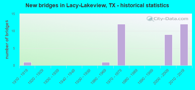
- New bridges - historical statistics
- 11910-1919
- 11960-1969
- 121970-1979
- 92000-2009
- 122010-2019

- Reconstructed bridges - Historical Statistics
- 11960-1969
- 11970-1979
- 01980-1989
- 01990-1999
- 22000-2009


- Bridge Condition - Deck
- 5.6%Very good
- 83.3%Good
- 11.1%Satisfactory

- Bridge Condition - Superstructure
- 50.0%Very good
- 38.9%Good
- 11.1%Satisfactory

- Bridge Condition - Substructure
- 88.9%Good
- 11.1%Satisfactory

- Bridge Condition - Channel
- 62.5%Good
- 37.5%Satisfactory

- Bridge Condition - Culverts
- 80.0%Good
- 20.0%Satisfactory
Find on map >> Show street view
Structure Number: 91610001409504, Location: 1.10 Mi N of FM 308 (Lat: 31.684750, Lng: -97.099150), Route carried "on" structure: Interstate 35, Year Built: 2013, Status: Open, Structure Length: 0.85m (2.79ft), Average Daily Traffic: 64,268 (year 2020), Truck Traffic: 27%, Average Future Daily Traffic: 84,260 (year 2033), Design Load: HS 20, Features Intersected: Cottonwood Creek
Minimum Vertical Clearance: 30+ m (98+ ft), Kilometerpoint: 3.344, Lanes on structure: 11, Owner: State Highway Agency, Approaching Roadway Width: 54.9m (180.1ft), Skew: 39 degrees, Material/Design: Concrete, Design/Construction: Culvert, Number Of Spans In Main Unit: 3, Length of Maximum Span: 2.4m (7.9ft)
Condition: Channel: Good, Culverts: Good, Operating Rating: 54.4 metric tons, Method Used To Determine Operating Rating: Assigned rating based on Load Factor Design (LFD) reported in metric tons, Inventory Rating: 32.7 metric tons, Method Used To Determine Inventory Rating: Assigned rating based on Load Factor Design (LFD) reported in metric tons, Structural Evaluation: Better than present minimum criteria, Waterway Adequacy: Superior to present desirable criteria, Approach Roadway Alignment: Equal to present desirable criteria, Designated Inspection Frequency: Every 48 months, Inspection Date: January 2021
Find on map >> Show street view
Structure Number: 91610001409511, Location: 4.9 Mi N of LP 340 N (Lat: 31.671822, Lng: -97.099453), Route carried "on" structure: Interstate 35, Year Built: 2013, Status: Open, Structure Length: 10.39m (34.09ft), Average Daily Traffic: 38,795 (year 2019), Truck Traffic: 35%, Average Future Daily Traffic: 90,650 (year 2037), Design Load: HL 93, Features Intersected: FM 308
Minimum Vertical Clearance: 30+ m (98+ ft), Kilometerpoint: 1.857, Lanes on structure: 3, Lanes under structure: 4, Base Highway Network: Yes, Owner: State Highway Agency, Approaching Roadway Width: 30.8m (101.0ft), Skew: 31 degrees, Material/Design: Prestressed concrete, Design/Construction: Stringer/Multi-beam, Number Of Spans In Main Unit: 3, Length of Maximum Span: 36.9m (121.1ft), Curb-To-Curb Width: 34.1m (111.9ft), Out-to-Out Width: 36.6m (120.1ft)
Condition: Deck: Good, Superstructure: Very good, Substructure: Good, Operating Rating: 54.4 metric tons, Method Used To Determine Operating Rating: Assigned ratings based on Load and Resistance Factor Design (LRFD) reported in metric tons, Inventory Rating: 32.7 metric tons, Method Used To Determine Inventory Rating: Assigned ratings based on Load and Resistance Factor Design (LRFD) reported in metric tons, Structural Evaluation: Better than present minimum criteria, Deck Geometry: Superior to present desirable criteria, Underclear: Better than present minimum criteria, Approach Roadway Alignment: Equal to present desirable criteria, Designated Inspection Frequency: Every 24 months, Inspection Date: January 2021, Deck Structure Type: Concrete Precast Panels
Find on map >> Show street view
Structure Number: 91610001409512, Location: 1.1 Mi N of FM 308 (Lat: 31.687700, Lng: -97.099631), Route carried "on" structure: Interstate 35, Year Built: 2013, Status: Open, Structure Length: 10.52m (34.51ft), Average Daily Traffic: 38,636 (year 2019), Truck Traffic: 35%, Average Future Daily Traffic: 45,325 (year 2037), Design Load: HL 93, Features Intersected: Hilltop Road
Minimum Vertical Clearance: 5.18m (16.99ft), Kilometerpoint: 3.693, Lanes on structure: 3, Lanes under structure: 4, Base Highway Network: Yes, Owner: State Highway Agency, Approaching Roadway Width: 17.7m (58.1ft), Skew: 3 degrees, Material/Design: Prestressed concrete, Design/Construction: Stringer/Multi-beam, Number Of Spans In Main Unit: 3, Length of Maximum Span: 38.1m (125.0ft), Curb-To-Curb Width: 17.7m (58.1ft), Out-to-Out Width: 18.3m (60.0ft)
Condition: Deck: Good, Superstructure: Very good, Substructure: Good, Operating Rating: 54.4 metric tons, Method Used To Determine Operating Rating: Assigned ratings based on Load and Resistance Factor Design (LRFD) reported in metric tons, Inventory Rating: 32.7 metric tons, Method Used To Determine Inventory Rating: Assigned ratings based on Load and Resistance Factor Design (LRFD) reported in metric tons, Structural Evaluation: Better than present minimum criteria, Deck Geometry: Better than present minimum criteria, Underclear: Superior to present desirable criteria, Approach Roadway Alignment: Equal to present desirable criteria, Designated Inspection Frequency: Every 24 months, Inspection Date: January 2021, Deck Structure Type: Concrete Precast Panels
Find on map >> Show street view
Structure Number: 91610001409513, Location: 1.1 Mi N of FM 308 (Lat: 31.688261, Lng: -97.100167), Route carried "on" structure: Interstate 35, Year Built: 2013, Status: Open, Structure Length: 10.52m (34.51ft), Average Daily Traffic: 38,795 (year 2019), Truck Traffic: 27%, Average Future Daily Traffic: 84,260 (year 2033), Design Load: HL 93, Features Intersected: Hilltop Road
Minimum Vertical Clearance: 5.18m (16.99ft), Kilometerpoint: 3.693, Lanes on structure: 3, Lanes under structure: 4, Base Highway Network: Yes, Owner: State Highway Agency, Approaching Roadway Width: 17.7m (58.1ft), Skew: 3 degrees, Material/Design: Prestressed concrete, Design/Construction: Stringer/Multi-beam, Number Of Spans In Main Unit: 3, Length of Maximum Span: 38.1m (125.0ft), Curb-To-Curb Width: 17.5m (57.4ft), Out-to-Out Width: 18.3m (60.0ft)
Condition: Deck: Good, Superstructure: Very good, Substructure: Good, Operating Rating: 54.4 metric tons, Method Used To Determine Operating Rating: Assigned ratings based on Load and Resistance Factor Design (LRFD) reported in metric tons, Inventory Rating: 32.7 metric tons, Method Used To Determine Inventory Rating: Assigned ratings based on Load and Resistance Factor Design (LRFD) reported in metric tons, Structural Evaluation: Better than present minimum criteria, Deck Geometry: Better than present minimum criteria, Underclear: Superior to present desirable criteria, Approach Roadway Alignment: Equal to present desirable criteria, Designated Inspection Frequency: Every 24 months, Inspection Date: January 2021, Deck Structure Type: Concrete Precast Panels
Find on map >> Show street view
Structure Number: 91610001501318, Location: 1.5 Mi NE of US 84 (Lat: 31.604717, Lng: -97.106508), Route carried "on" structure: Interstate 35, Year Built: 1972, Status: Not yet open, Structure Length: 9.75m (31.99ft), Average Daily Traffic: 47,401 (year 2017), Truck Traffic: 31%, Average Future Daily Traffic: 112,390 (year 2037), Design Load: HS 20, Features Intersected: Loop 340
Minimum Vertical Clearance: 30+ m (98+ ft), Kilometerpoint: 30.903, Lanes on structure: 4, Lanes under structure: 6, Base Highway Network: Yes, Owner: State Highway Agency, Approaching Roadway Width: 16.5m (54.1ft), Material/Design: Prestressed concrete, Design/Construction: Stringer/Multi-beam, Number Of Spans In Main Unit: 4, Length of Maximum Span: 24.4m (80.1ft), Curb-To-Curb Width: 16.5m (54.1ft), Out-to-Out Width: 17.0m (55.8ft)
Condition: Deck: Good, Superstructure: Good, Substructure: Good, Operating Rating: 54.4 metric tons, Method Used To Determine Operating Rating: Assigned rating based on Load Factor Design (LFD) reported in metric tons, Inventory Rating: 32.7 metric tons, Method Used To Determine Inventory Rating: Assigned rating based on Load Factor Design (LFD) reported in metric tons, Structural Evaluation: Better than present minimum criteria, Deck Geometry: Meets minimum limits, Underclear: Superior to present desirable criteria, Approach Roadway Alignment: Equal to present desirable criteria, Length Of Structure Improvement: 12.19m (39.99ft), Designated Inspection Frequency: Every 24 months, Inspection Date: Febuary 2021, Bridge Improvement Cost: $1,200,000, Roadway Improvement Cost: $300,000, Total Project Cost: $1,800,000, Deck Structure Type: Concrete Cast-file-Place, Wearing Surface/Protective System: Wearing Surface: Bituminous
Find on map >> Show street view
Structure Number: 9161000150132, Location: 0.2 Mi N of LP 340 N (Lat: 31.607336, Lng: -97.105294), Route carried "on" structure: Interstate 35, Year Built: 1972, Status: Not yet open, Structure Length: 6.40m (21.00ft), Average Daily Traffic: 47,401 (year 2017), Truck Traffic: 31%, Average Future Daily Traffic: 56,195 (year 2037), Design Load: HS 20, Features Intersected: Union Pacific RR
Minimum Vertical Clearance: 30+ m (98+ ft), Kilometerpoint: 31.303, Lanes on structure: 3, Base Highway Network: Yes, Owner: State Highway Agency, Approaching Roadway Width: 15.9m (52.2ft), Skew: 1 degrees, Material/Design: Concrete continuous, Design/Construction: Slab, Number Of Spans In Main Unit: 4, Length of Maximum Span: 18.3m (60.0ft), Curb-To-Curb Width: 20.1m (65.9ft), Out-to-Out Width: 26.6m (87.3ft)
Condition: Deck: Good, Superstructure: Good, Substructure: Satisfactory, Operating Rating: 68.0 metric tons, Method Used To Determine Operating Rating: Load Factor (LF), Inventory Rating: 40.8 metric tons, Method Used To Determine Inventory Rating: Load Factor (LF), Structural Evaluation: Equal to present minimum criteria, Deck Geometry: Superior to present desirable criteria, Underclear: Equal to present desirable criteria, Approach Roadway Alignment: Equal to present desirable criteria, Length Of Structure Improvement: 8.23m (27.00ft), Designated Inspection Frequency: Every 24 months, Inspection Date: Febuary 2021, Bridge Improvement Cost: $800,000, Roadway Improvement Cost: $200,000, Total Project Cost: $1,200,000, Deck Structure Type: Concrete Cast-file-Place, Wearing Surface/Protective System: Wearing Surface: Bituminous
Find on map >> Show street view
Structure Number: 91610001501321, Location: 0.2 Mi N of LP 340 N (Lat: 31.607544, Lng: -97.104642), Route carried "on" structure: Interstate 35, Year Built: 1972, Status: Open, Structure Length: 6.40m (21.00ft), Average Daily Traffic: 43,233 (year 2017), Truck Traffic: 31%, Average Future Daily Traffic: 112,390 (year 2037), Design Load: HS 20, Features Intersected: Union Pacific Railroad
Minimum Vertical Clearance: 30+ m (98+ ft), Kilometerpoint: 31.299, Lanes on structure: 4, Base Highway Network: Yes, Owner: State Highway Agency, Approaching Roadway Width: 15.9m (52.2ft), Skew: 1 degrees, Material/Design: Concrete continuous, Design/Construction: Slab, Number Of Spans In Main Unit: 4, Length of Maximum Span: 18.3m (60.0ft), Curb-To-Curb Width: 15.9m (52.2ft), Out-to-Out Width: 22.2m (72.8ft)
Condition: Deck: Good, Superstructure: Good, Substructure: Good, Operating Rating: 68.0 metric tons, Method Used To Determine Operating Rating: Load Factor (LF), Inventory Rating: 40.8 metric tons, Method Used To Determine Inventory Rating: Load Factor (LF), Structural Evaluation: Better than present minimum criteria, Deck Geometry: Meets minimum limits, Underclear: Superior to present desirable criteria, Approach Roadway Alignment: Equal to present desirable criteria, Length Of Structure Improvement: 8.23m (27.00ft), Designated Inspection Frequency: Every 24 months, Inspection Date: Febuary 2021, Bridge Improvement Cost: $800,000, Roadway Improvement Cost: $200,000, Total Project Cost: $1,200,000, Deck Structure Type: Concrete Cast-file-Place, Wearing Surface/Protective System: Wearing Surface: Bituminous
Find on map >> Show street view
Structure Number: 91610001501322, Location: 0.3 Mi N of LP 340 (Lat: 31.608169, Lng: -97.105858), Route carried "on" structure: Interstate 35, Year Built: 1972, Status: Open, Structure Length: 0.64m (2.10ft), Average Daily Traffic: 77,498 (year 2020), Truck Traffic: 23%, Average Future Daily Traffic: 112,510 (year 2033), Design Load: HS 20, Features Intersected: Drainage Ditch
Minimum Vertical Clearance: 30+ m (98+ ft), Kilometerpoint: 31.484, Lanes on structure: 10, Owner: State Highway Agency, Approaching Roadway Width: 43.9m (144.0ft), Skew: 34 degrees, Material/Design: Concrete, Design/Construction: Culvert, Number Of Spans In Main Unit: 2, Length of Maximum Span: 2.1m (6.9ft)
Condition: Channel: Good, Culverts: Good, Operating Rating: 39.9 metric tons, Method Used To Determine Operating Rating: Load Factor (LF), Inventory Rating: 23.6 metric tons, Method Used To Determine Inventory Rating: Load Factor (LF), Structural Evaluation: Somewhat better than minimum adequacy, Waterway Adequacy: Superior to present desirable criteria, Approach Roadway Alignment: Equal to present desirable criteria, Length Of Structure Improvement: 1.83m (6.00ft), Designated Inspection Frequency: Every 24 months, Inspection Date: Febuary 2021, Bridge Improvement Cost: $200,000, Roadway Improvement Cost: $100,000, Total Project Cost: $400,000
Find on map >> Show street view
Structure Number: 91610001501323, Location: 0.70 Mi N of LP 340 N (Lat: 31.613169, Lng: -97.102469), Route carried "on" structure: Interstate 35, Year Built: 1972, Year Reconstructed: 2013, Status: Open, Structure Length: 0.64m (2.10ft), Average Daily Traffic: 77,498 (year 2020), Truck Traffic: 32%, Average Future Daily Traffic: 112,390 (year 2037), Design Load: HS 20, Features Intersected: Drainage Ditch
Minimum Vertical Clearance: 30+ m (98+ ft), Kilometerpoint: 32.061, Lanes on structure: 13, Base Highway Network: Yes, Owner: State Highway Agency, Approaching Roadway Width: 51.8m (169.9ft), Skew: 25 degrees, Material/Design: Concrete, Design/Construction: Culvert, Number Of Spans In Main Unit: 2, Length of Maximum Span: 1.8m (5.9ft)
Condition: Channel: Good, Culverts: Good, Operating Rating: 39.9 metric tons, Method Used To Determine Operating Rating: Load Factor (LF), Inventory Rating: 23.6 metric tons, Method Used To Determine Inventory Rating: Load Factor (LF), Structural Evaluation: Somewhat better than minimum adequacy, Waterway Adequacy: Superior to present desirable criteria, Approach Roadway Alignment: Equal to present desirable criteria, Length Of Structure Improvement: 1.83m (6.00ft), Designated Inspection Frequency: Every 24 months, Inspection Date: Febuary 2021, Bridge Improvement Cost: $400,000, Roadway Improvement Cost: $100,000, Total Project Cost: $700,000
Find on map >> Show street view
Structure Number: 91610001501324, Location: 0.7 Mi N of LP 340 N (Lat: 31.614644, Lng: -97.101750), Route carried "on" structure: Interstate 35, Year Built: 1972, Status: Open, Structure Length: 5.64m (18.50ft), Average Daily Traffic: 47,401 (year 2017), Truck Traffic: 32%, Average Future Daily Traffic: 56,195 (year 2037), Design Load: HS 20, Features Intersected: Meyers Lane
Minimum Vertical Clearance: 30+ m (98+ ft), Kilometerpoint: 32.137, Lanes on structure: 3, Lanes under structure: 4, Base Highway Network: Yes, Owner: State Highway Agency, Approaching Roadway Width: 15.9m (52.2ft), Skew: 3 degrees, Material/Design: Concrete continuous, Design/Construction: Tee Beam, Number Of Spans In Main Unit: 1, Number Of Approach Spans: 2, Length of Maximum Span: 25.9m (85.0ft), Curb-To-Curb Width: 16.5m (54.1ft), Out-to-Out Width: 17.0m (55.8ft)
Condition: Deck: Good, Superstructure: Good, Substructure: Good, Operating Rating: 39.0 metric tons, Method Used To Determine Operating Rating: Load Factor (LF), Inventory Rating: 23.6 metric tons, Method Used To Determine Inventory Rating: Load Factor (LF), Structural Evaluation: Somewhat better than minimum adequacy, Deck Geometry: Equal to present minimum criteria, Underclear: Somewhat better than minimum adequacy, Approach Roadway Alignment: Equal to present desirable criteria, Length Of Structure Improvement: 7.32m (24.02ft), Designated Inspection Frequency: Every 24 months, Inspection Date: Febuary 2021, Bridge Improvement Cost: $700,000, Roadway Improvement Cost: $200,000, Total Project Cost: $1,100,000, Deck Structure Type: Concrete Cast-file-Place, Wearing Surface/Protective System: Wearing Surface: Bituminous
Find on map >> Show street view
Structure Number: 91610001501325, Location: 0.7 Mi N of LP 340 N (Lat: 31.614383, Lng: -97.101414), Route carried "on" structure: Interstate 35, Year Built: 1972, Status: Open, Structure Length: 5.64m (18.50ft), Average Daily Traffic: 43,233 (year 2017), Truck Traffic: 32%, Average Future Daily Traffic: 56,195 (year 2037), Design Load: HS 20, Features Intersected: Meyers Lane
Minimum Vertical Clearance: 30+ m (98+ ft), Kilometerpoint: 32.153, Lanes on structure: 3, Lanes under structure: 4, Base Highway Network: Yes, Owner: State Highway Agency, Approaching Roadway Width: 15.9m (52.2ft), Skew: 3 degrees, Material/Design: Concrete continuous, Design/Construction: Tee Beam, Number Of Spans In Main Unit: 1, Number Of Approach Spans: 2, Length of Maximum Span: 25.9m (85.0ft), Curb-To-Curb Width: 16.5m (54.1ft), Out-to-Out Width: 17.0m (55.8ft)
Condition: Deck: Good, Superstructure: Good, Substructure: Good, Operating Rating: 39.0 metric tons, Method Used To Determine Operating Rating: Load Factor (LF), Inventory Rating: 23.6 metric tons, Method Used To Determine Inventory Rating: Load Factor (LF), Structural Evaluation: Somewhat better than minimum adequacy, Deck Geometry: Equal to present minimum criteria, Underclear: Somewhat better than minimum adequacy, Approach Roadway Alignment: Equal to present desirable criteria, Length Of Structure Improvement: 7.32m (24.02ft), Designated Inspection Frequency: Every 24 months, Inspection Date: Febuary 2021, Bridge Improvement Cost: $700,000, Roadway Improvement Cost: $200,000, Total Project Cost: $1,100,000, Deck Structure Type: Concrete Cast-file-Place, Wearing Surface/Protective System: Wearing Surface: Bituminous
Find on map >> Show street view
Structure Number: 91610001501326, Location: 1.6 MI N OF LP 340N (Lat: 31.623322, Lng: -97.097108), Route carried "on" structure: Interstate 35, Year Built: 1972, Year Reconstructed: 2013, Status: Open, Structure Length: 0.70m (2.30ft), Average Daily Traffic: 77,498 (year 2020), Truck Traffic: 23%, Average Future Daily Traffic: 112,510 (year 2033), Design Load: HS 20, Features Intersected: DRAINAGE DITCH
Minimum Vertical Clearance: 30+ m (98+ ft), Kilometerpoint: 33.677, Lanes on structure: 12, Owner: State Highway Agency, Approaching Roadway Width: 49.4m (162.1ft), Skew: 39 degrees, Material/Design: Concrete, Design/Construction: Culvert, Number Of Spans In Main Unit: 3, Length of Maximum Span: 2.1m (6.9ft)
Condition: Channel: Good, Culverts: Good, Operating Rating: 39.9 metric tons, Method Used To Determine Operating Rating: Load Factor (LF), Inventory Rating: 23.6 metric tons, Method Used To Determine Inventory Rating: Load Factor (LF), Structural Evaluation: Somewhat better than minimum adequacy, Waterway Adequacy: Superior to present desirable criteria, Approach Roadway Alignment: Equal to present desirable criteria, Length Of Structure Improvement: 1.83m (6.00ft), Designated Inspection Frequency: Every 24 months, Inspection Date: March 2021, Bridge Improvement Cost: $200,000, Roadway Improvement Cost: $100,000, Total Project Cost: $400,000
Find on map >> Show street view
Structure Number: 91610001501467, Location: 1.8 Mi N of N LP 340 (Lat: 31.627439, Lng: -97.095586), Route carried "on" structure: Interstate 35, Year Built: 2003, Status: Open, Structure Length: 8.23m (27.00ft), Average Daily Traffic: 43,233 (year 2017), Truck Traffic: 32%, Average Future Daily Traffic: 56,195 (year 2037), Design Load: HS 25 or greater, Features Intersected: Craven Ave
Minimum Vertical Clearance: 30+ m (98+ ft), Kilometerpoint: 33.724, Lanes on structure: 3, Lanes under structure: 4, Base Highway Network: Yes, Owner: State Highway Agency, Approaching Roadway Width: 17.4m (57.1ft), Skew: 4 degrees, Material/Design: Prestressed concrete, Design/Construction: Stringer/Multi-beam, Number Of Spans In Main Unit: 4, Length of Maximum Span: 22.9m (75.1ft), Curb-To-Curb Width: 17.4m (57.1ft), Out-to-Out Width: 21.6m (70.9ft)
Condition: Deck: Good, Superstructure: Very good, Substructure: Good, Operating Rating: 55.3 metric tons, Method Used To Determine Operating Rating: Assigned rating based on Load Factor Design (LFD) reported in metric tons, Inventory Rating: 40.8 metric tons, Method Used To Determine Inventory Rating: Assigned rating based on Load Factor Design (LFD) reported in metric tons, Structural Evaluation: Better than present minimum criteria, Deck Geometry: Better than present minimum criteria, Underclear: Meets minimum limits, Approach Roadway Alignment: Equal to present desirable criteria, Designated Inspection Frequency: Every 24 months, Inspection Date: Febuary 2021, Deck Structure Type: Concrete Precast Panels
Find on map >> Show street view
Structure Number: 91610001501468, Location: 1.8 Mi N of N LP 340 (Lat: 31.627961, Lng: -97.095847), Route carried "on" structure: Interstate 35, Year Built: 2003, Status: Open, Structure Length: 8.23m (27.00ft), Average Daily Traffic: 47,401 (year 2017), Truck Traffic: 32%, Average Future Daily Traffic: 56,195 (year 2037), Design Load: HS 25 or greater, Features Intersected: Craven Ave
Minimum Vertical Clearance: 30+ m (98+ ft), Kilometerpoint: 33.703, Lanes on structure: 3, Lanes under structure: 4, Base Highway Network: Yes, Owner: State Highway Agency, Approaching Roadway Width: 17.4m (57.1ft), Skew: 4 degrees, Material/Design: Prestressed concrete, Design/Construction: Stringer/Multi-beam, Number Of Spans In Main Unit: 4, Length of Maximum Span: 22.9m (75.1ft), Curb-To-Curb Width: 17.4m (57.1ft), Out-to-Out Width: 21.6m (70.9ft)
Condition: Deck: Good, Superstructure: Good, Substructure: Good, Operating Rating: 55.3 metric tons, Method Used To Determine Operating Rating: Assigned rating based on Load Factor Design (LFD) reported in metric tons, Inventory Rating: 40.8 metric tons, Method Used To Determine Inventory Rating: Assigned rating based on Load Factor Design (LFD) reported in metric tons, Structural Evaluation: Better than present minimum criteria, Deck Geometry: Better than present minimum criteria, Underclear: Meets minimum limits, Approach Roadway Alignment: Equal to present desirable criteria, Designated Inspection Frequency: Every 24 months, Inspection Date: Febuary 2021, Deck Structure Type: Concrete Precast Panels
Find on map >> Show street view
Structure Number: 91610001501469, Location: 2.6 Mi N of LP 340 (Lat: 31.639069, Lng: -97.096061), Route carried "on" structure: Interstate 35, Year Built: 2003, Status: Open, Structure Length: 7.92m (25.98ft), Average Daily Traffic: 778,093 (year 2017), Truck Traffic: 34%, Average Future Daily Traffic: 109,330 (year 2037), Design Load: HS 25 or greater, Features Intersected: FM 2417
Minimum Vertical Clearance: 30+ m (98+ ft), Kilometerpoint: 35.013, Lanes on structure: 3, Lanes under structure: 4, Base Highway Network: Yes, Owner: State Highway Agency, Approaching Roadway Width: 17.4m (57.1ft), Skew: 2 degrees, Material/Design: Prestressed concrete, Design/Construction: Stringer/Multi-beam, Number Of Spans In Main Unit: 4, Length of Maximum Span: 19.8m (65.0ft), Curb-To-Curb Width: 17.4m (57.1ft), Out-to-Out Width: 21.6m (70.9ft)
Condition: Deck: Good, Superstructure: Very good, Substructure: Good, Operating Rating: 55.3 metric tons, Method Used To Determine Operating Rating: Assigned rating based on Load Factor Design (LFD) reported in metric tons, Inventory Rating: 40.8 metric tons, Method Used To Determine Inventory Rating: Assigned rating based on Load Factor Design (LFD) reported in metric tons, Structural Evaluation: Better than present minimum criteria, Deck Geometry: Better than present minimum criteria, Underclear: Meets minimum limits, Approach Roadway Alignment: Equal to present desirable criteria, Designated Inspection Frequency: Every 24 months, Inspection Date: Febuary 2021, Deck Structure Type: Concrete Precast Panels
Find on map >> Show street view
Structure Number: 9161000150147, Location: 2.6 Mi N of LP 340 (Lat: 31.639558, Lng: -97.096433), Route carried "on" structure: Interstate 35, Year Built: 2003, Status: Open, Structure Length: 7.92m (25.98ft), Average Daily Traffic: 39,544 (year 2017), Truck Traffic: 34%, Average Future Daily Traffic: 109,330 (year 2037), Design Load: HS 25 or greater, Features Intersected: FM 2417
Minimum Vertical Clearance: 30+ m (98+ ft), Kilometerpoint: 35.000, Lanes on structure: 3, Lanes under structure: 4, Base Highway Network: Yes, Owner: State Highway Agency, Approaching Roadway Width: 17.4m (57.1ft), Skew: 2 degrees, Material/Design: Prestressed concrete, Design/Construction: Stringer/Multi-beam, Number Of Spans In Main Unit: 4, Length of Maximum Span: 19.8m (65.0ft), Curb-To-Curb Width: 17.4m (57.1ft), Out-to-Out Width: 21.6m (70.9ft)
Condition: Deck: Good, Superstructure: Good, Substructure: Good, Operating Rating: 55.3 metric tons, Method Used To Determine Operating Rating: Assigned rating based on Load Factor Design (LFD) reported in metric tons, Inventory Rating: 40.8 metric tons, Method Used To Determine Inventory Rating: Assigned rating based on Load Factor Design (LFD) reported in metric tons, Structural Evaluation: Better than present minimum criteria, Deck Geometry: Better than present minimum criteria, Underclear: Meets minimum limits, Approach Roadway Alignment: Equal to present desirable criteria, Designated Inspection Frequency: Every 24 months, Inspection Date: Febuary 2021, Deck Structure Type: Concrete Precast Panels
Find on map >> Show street view
Structure Number: 91610001501539, Location: 0.2 Mi N of Loop 340 (Lat: 31.607856, Lng: -97.105672), Route carried "on" structure: ServiceInterstate 35, Year Built: 2012, Status: Open, Structure Length: 6.40m (21.00ft), Average Daily Traffic: 2,429 (year 2017), Truck Traffic: 3%, Average Future Daily Traffic: 3,400 (year 2037), Design Load: HL 93, Features Intersected: UPRR
Minimum Vertical Clearance: 30+ m (98+ ft), Kilometerpoint: 31.250, Lanes on structure: 3, Owner: State Highway Agency, Approaching Roadway Width: 12.8m (42.0ft), Skew: 1 degrees, Material/Design: Prestressed concrete, Design/Construction: Stringer/Multi-beam, Number Of Spans In Main Unit: 1, Number Of Approach Spans: 2, Length of Maximum Span: 36.6m (120.1ft), Curb-To-Curb Width: 13.4m (44.0ft), Out-to-Out Width: 14.0m (45.9ft)
Condition: Deck: Good, Superstructure: Very good, Substructure: Good, Operating Rating: 54.4 metric tons, Method Used To Determine Operating Rating: Assigned ratings based on Load and Resistance Factor Design (LRFD) reported in metric tons, Inventory Rating: 32.7 metric tons, Method Used To Determine Inventory Rating: Assigned ratings based on Load and Resistance Factor Design (LRFD) reported in metric tons, Structural Evaluation: Better than present minimum criteria, Deck Geometry: Somewhat better than minimum adequacy, Underclear: Superior to present desirable criteria, Approach Roadway Alignment: Equal to present desirable criteria, Designated Inspection Frequency: Every 24 months, Inspection Date: March 2021, Deck Structure Type: Concrete Precast Panels
Find on map >> Show street view
Structure Number: 9161000150154, Location: 3.4 Mi N of N LP 340 (Lat: 31.650375, Lng: -97.099950), Route carried "on" structure: Interstate 35, Year Built: 2013, Status: Open, Structure Length: 10.52m (34.51ft), Average Daily Traffic: 38,549 (year 2017), Truck Traffic: 34%, Average Future Daily Traffic: 54,665 (year 2037), Design Load: HL 93, Features Intersected: Bus 77
Minimum Vertical Clearance: 30+ m (98+ ft), Kilometerpoint: 36.431, Lanes on structure: 4, Lanes under structure: 5, Base Highway Network: Yes, Owner: State Highway Agency, Approaching Roadway Width: 21.3m (69.9ft), Material/Design: Prestressed concrete, Design/Construction: Stringer/Multi-beam, Number Of Spans In Main Unit: 3, Length of Maximum Span: 38.1m (125.0ft), Curb-To-Curb Width: 21.3m (69.9ft), Out-to-Out Width: 21.9m (71.9ft)
Condition: Deck: Very good, Superstructure: Very good, Substructure: Good, Operating Rating: 54.4 metric tons, Method Used To Determine Operating Rating: Assigned ratings based on Load and Resistance Factor Design (LRFD) reported in metric tons, Inventory Rating: 32.7 metric tons, Method Used To Determine Inventory Rating: Assigned ratings based on Load and Resistance Factor Design (LRFD) reported in metric tons, Structural Evaluation: Better than present minimum criteria, Deck Geometry: Better than present minimum criteria, Underclear: Equal to present minimum criteria, Approach Roadway Alignment: Equal to present desirable criteria, Designated Inspection Frequency: Every 24 months, Inspection Date: January 2021, Deck Structure Type: Concrete Precast Panels
Find on map >> Show street view
Structure Number: 91610001501541, Location: 3.4 Mi N of N LP 340 (Lat: 31.651111, Lng: -97.100553), Route carried "on" structure: Interstate 35, Year Built: 2013, Status: Open, Structure Length: 10.52m (34.51ft), Average Daily Traffic: 39,047 (year 2017), Truck Traffic: 34%, Average Future Daily Traffic: 54,665 (year 2037), Design Load: HL 93, Features Intersected: Bus 77
Minimum Vertical Clearance: 30+ m (98+ ft), Kilometerpoint: 36.415, Lanes on structure: 3, Lanes under structure: 5, Base Highway Network: Yes, Owner: State Highway Agency, Approaching Roadway Width: 18.3m (60.0ft), Material/Design: Prestressed concrete, Design/Construction: Stringer/Multi-beam, Number Of Spans In Main Unit: 3, Length of Maximum Span: 38.1m (125.0ft), Curb-To-Curb Width: 17.7m (58.1ft), Out-to-Out Width: 18.3m (60.0ft)
Condition: Deck: Good, Superstructure: Very good, Substructure: Good, Operating Rating: 54.4 metric tons, Method Used To Determine Operating Rating: Assigned ratings based on Load and Resistance Factor Design (LRFD) reported in metric tons, Inventory Rating: 32.7 metric tons, Method Used To Determine Inventory Rating: Assigned ratings based on Load and Resistance Factor Design (LRFD) reported in metric tons, Structural Evaluation: Better than present minimum criteria, Deck Geometry: Better than present minimum criteria, Underclear: Equal to present minimum criteria, Approach Roadway Alignment: Equal to present desirable criteria, Designated Inspection Frequency: Every 24 months, Inspection Date: January 2021, Deck Structure Type: Concrete Precast Panels
Find on map >> Show street view
Structure Number: 91610020907004, Location: 3.1 Mi N of US 84 (Lat: 31.621428, Lng: -97.124981), Route carried "on" structure: State highway 933, Year Built: 2007, Status: Open, Structure Length: 5.49m (18.01ft), Average Daily Traffic: 10,086 (year 2017), Truck Traffic: 3%, Average Future Daily Traffic: 14,120 (year 2037), Design Load: HS 20, Features Intersected: White Rock Creek
Minimum Vertical Clearance: 30+ m (98+ ft), Kilometerpoint: 22.961, Lanes on structure: 4, Base Highway Network: Yes, Owner: State Highway Agency, Approaching Roadway Width: 25.6m (84.0ft), Material/Design: Prestressed concrete, Design/Construction: Stringer/Multi-beam, Number Of Spans In Main Unit: 3, Length of Maximum Span: 18.3m (60.0ft), Curb-To-Curb Width: 25.6m (84.0ft), Out-to-Out Width: 26.2m (86.0ft)
Condition: Deck: Good, Superstructure: Very good, Substructure: Good, Channel: Good, Operating Rating: 54.4 metric tons, Method Used To Determine Operating Rating: Assigned rating based on Load Factor Design (LFD) reported in metric tons, Inventory Rating: 32.7 metric tons, Method Used To Determine Inventory Rating: Assigned rating based on Load Factor Design (LFD) reported in metric tons, Structural Evaluation: Better than present minimum criteria, Deck Geometry: Superior to present desirable criteria, Waterway Adequacy: Superior to present desirable criteria, Approach Roadway Alignment: Equal to present desirable criteria, Designated Inspection Frequency: Every 24 months, Inspection Date: Febuary 2021, Deck Structure Type: Concrete Precast Panels
Find on map >> Show street view
Structure Number: 91610083404007, Location: 0.8 Mi NE of IH 35 (Lat: 31.677556, Lng: -97.088472), Route carried "on" structure: State highway 308, Year Built: 1914, Year Reconstructed: 1968, Status: Open, Structure Length: 1.43m (4.69ft), Average Daily Traffic: 2,315 (year 2018), Truck Traffic: 10%, Average Future Daily Traffic: 3,220 (year 2033), Features Intersected: Trib Little Tehuacana Cr
Minimum Vertical Clearance: 30+ m (98+ ft), Kilometerpoint: 16.121, Lanes on structure: 2, Owner: State Highway Agency, Approaching Roadway Width: 9.8m (32.2ft), Skew: 4 degrees, Material/Design: Concrete, Design/Construction: Culvert, Number Of Spans In Main Unit: 4, Length of Maximum Span: 3.0m (9.8ft)
Condition: Channel: Satisfactory, Culverts: Satisfactory, Operating Rating: 39.9 metric tons, Method Used To Determine Operating Rating: Load Factor (LF), Inventory Rating: 23.6 metric tons, Method Used To Determine Inventory Rating: Load Factor (LF), Structural Evaluation: Equal to present minimum criteria, Waterway Adequacy: Equal to present minimum criteria, Approach Roadway Alignment: Equal to present desirable criteria, Length Of Structure Improvement: 1.83m (6.00ft), Designated Inspection Frequency: Every 24 months, Inspection Date: January 2021, Bridge Improvement Cost: $200,000, Roadway Improvement Cost: $100,000, Total Project Cost: $400,000
Find on map >> Show street view
Structure Number: 91610083405027, Location: 1.60 Mi SW of IH 35 (Lat: 31.659133, Lng: -97.123053), Route carried "on" structure: State highway 308, Year Built: 1971, Year Reconstructed: 1978, Status: Open, Structure Length: 4.57m (14.99ft), Average Daily Traffic: 4,167 (year 2020), Truck Traffic: 11%, Average Future Daily Traffic: 5,880 (year 2033), Features Intersected: White Rock Creek
Minimum Vertical Clearance: 30+ m (98+ ft), Kilometerpoint: 10.589, Lanes on structure: 2, Owner: State Highway Agency, Approaching Roadway Width: 10.4m (34.1ft), Material/Design: Concrete, Design/Construction: Tee Beam, Number Of Spans In Main Unit: 5, Length of Maximum Span: 9.1m (29.9ft), Curb-To-Curb Width: 9.5m (31.2ft), Out-to-Out Width: 11.0m (36.1ft)
Condition: Deck: Satisfactory, Superstructure: Satisfactory, Substructure: Good, Channel: Satisfactory, Operating Rating: 32.7 metric tons, Method Used To Determine Operating Rating: Field evaluation and documented engineering judgment, Inventory Rating: 24.5 metric tons, Method Used To Determine Inventory Rating: Field evaluation and documented engineering judgment, Structural Evaluation: Equal to present minimum criteria, Deck Geometry: Meets minimum limits, Waterway Adequacy: Equal to present minimum criteria, Approach Roadway Alignment: Equal to present desirable criteria, Length Of Structure Improvement: 6.40m (21.00ft), Designated Inspection Frequency: Every 24 months, Inspection Date: January 2021, Bridge Improvement Cost: $700,000, Roadway Improvement Cost: $200,000, Total Project Cost: $1,100,000, Deck Structure Type: Concrete Cast-file-Place, Wearing Surface/Protective System: Wearing Surface: Bituminous
Find on map >> Show street view
Structure Number: 91610AA0423001, Location: 0.05 MI NW OF FM 308 (Lat: 31.659781, Lng: -97.123578), Route carried "on" structure: County highway , Year Built: 1968, Status: Posted for load, Structure Length: 0.94m (3.08ft), Average Daily Traffic: 367 (year 2020), Average Future Daily Traffic: 400 (year 2036), Features Intersected: WHITE ROCK CRK TRIB #561, Facility Carried by Structure: MEIXNER RD
Minimum Vertical Clearance: 30+ m (98+ ft), Kilometerpoint: 0.080, Lanes on structure: 1, Owner: County Highway Agency, Approaching Roadway Width: 4.6m (15.1ft), Material/Design: Prestressed concrete, Number Of Spans In Main Unit: 1, Length of Maximum Span: 9.1m (29.9ft), Curb-To-Curb Width: 4.5m (14.8ft), Out-to-Out Width: 4.9m (16.1ft)
Condition: Deck: Satisfactory, Superstructure: Satisfactory, Substructure: Satisfactory, Channel: Satisfactory, Operating Rating: 38.1 metric tons, Method Used To Determine Operating Rating: Allowable Stress (AS), Inventory Rating: 22.7 metric tons, Method Used To Determine Inventory Rating: Allowable Stress (AS), Structural Evaluation: Equal to present minimum criteria, Deck Geometry: High priority of replacement, Waterway Adequacy: Better than present minimum criteria, Approach Roadway Alignment: Equal to present desirable criteria, Bridge Posting: Required (Relationship of Operating Rating to Maximum Legal Load: 0.1 - 9.9% below), Length Of Structure Improvement: 1.83m (6.00ft), Designated Inspection Frequency: Every 24 months, Inspection Date: April 2020, Bridge Improvement Cost: $167,000, Roadway Improvement Cost: $41,000, Total Project Cost: $208,000, Deck Structure Type: Concrete Precast Panels, Wearing Surface/Protective System: Wearing Surface: Bituminous
Find on map >> Show street view
Structure Number: 91610001409511, Location: 4.9 Mi N of LP 340 N (Lat: 31.671822, Lng: -97.099453), Route carried "under" structure: State highway 308, Year Built: 2013, Structure Length: 0. m, Average Daily Traffic: 3,960 (year 2013), Truck Traffic: 11%, Features Intersected: FM 308, Facility Carried by Structure: IH 35
Minimum Vertical Clearance: 5.11m (16.77ft), Kilometerpoint: 17.474, Lanes on structure: 6, Lanes under structure: 4, Material/Design: Prestressed concrete, Design/Construction: Stringer/Multi-beam, Length of Maximum Span: 36.9m (121.1ft)
Find on map >> Show street view
Structure Number: 91610001409512, Location: 1.1 Mi N of FM 308 (Lat: 31.687700, Lng: -97.099631), Route carried "under" structure: County highway , Year Built: 2013, Structure Length: 0. m, Average Daily Traffic: 116 (year 2012), Truck Traffic: 5%, Features Intersected: Hilltop Road, Facility Carried by Structure: IH 35 NB
Minimum Vertical Clearance: 5.18m (16.99ft), Kilometerpoint: 1.609, Lanes on structure: 3, Lanes under structure: 4, Material/Design: Prestressed concrete, Design/Construction: Stringer/Multi-beam, Length of Maximum Span: 38.1m (125.0ft)
Find on map >> Show street view
Structure Number: 91610001409513, Location: 1.1 Mi N of FM 308 (Lat: 31.688261, Lng: -97.100167), Route carried "under" structure: County highway , Year Built: 2013, Structure Length: 0. m, Average Daily Traffic: 116 (year 2012), Truck Traffic: 5%, Features Intersected: Hilltop Road, Facility Carried by Structure: IH 35 SB
Minimum Vertical Clearance: 5.18m (16.99ft), Kilometerpoint: 1.609, Lanes on structure: 3, Lanes under structure: 4, Material/Design: Prestressed concrete, Design/Construction: Stringer/Multi-beam, Length of Maximum Span: 38.1m (125.0ft)
Find on map >> Show street view
Structure Number: 91610001501318, Location: 1.5 Mi NE of US 84 (Lat: 31.604717, Lng: -97.106508), Route carried "under" structure: State highway 340, Year Built: 1972, Structure Length: 0. m, Average Daily Traffic: 20,899 (year 2017), Truck Traffic: 17%, Features Intersected: Loop 340, Facility Carried by Structure: IH 35 SB
Minimum Vertical Clearance: 5.72m (18.77ft), Kilometerpoint: 11.370, Lanes on structure: 3, Lanes under structure: 6, Material/Design: Prestressed concrete, Design/Construction: Stringer/Multi-beam, Length of Maximum Span: 24.4m (80.1ft)
Find on map >> Show street view
Structure Number: 91610001501324, Location: 0.7 Mi N of LP 340 N (Lat: 31.614644, Lng: -97.101750), Route carried "under" structure: City street , Year Built: 1972, Structure Length: 0. m, Average Daily Traffic: 1,000 (year 2017), Truck Traffic: 5%, Features Intersected: Meyers Lane, Facility Carried by Structure: IH 35 SB
Minimum Vertical Clearance: 4.95m (16.24ft), Kilometerpoint: 0.000, Lanes on structure: 3, Lanes under structure: 4, Material/Design: Concrete continuous, Design/Construction: Tee Beam, Length of Maximum Span: 25.9m (85.0ft)
Find on map >> Show street view
Structure Number: 91610001501325, Location: 0.7 Mi N of LP 340 N (Lat: 31.614383, Lng: -97.101414), Route carried "under" structure: City street , Year Built: 1972, Structure Length: 0. m, Average Daily Traffic: 1,000 (year 2017), Truck Traffic: 5%, Features Intersected: Meyers Lane, Facility Carried by Structure: IH 35 NB
Minimum Vertical Clearance: 4.95m (16.24ft), Kilometerpoint: 0.000, Lanes on structure: 3, Lanes under structure: 4, Material/Design: Concrete continuous, Design/Construction: Tee Beam, Length of Maximum Span: 25.9m (85.0ft)
Find on map >> Show street view
Structure Number: 91610001501467, Location: 1.8 Mi N of N LP 340 (Lat: 31.627439, Lng: -97.095586), Route carried "under" structure: City street , Year Built: 2003, Structure Length: 0. m, Average Daily Traffic: 2,000 (year 2017), Truck Traffic: 5%, Features Intersected: Craven Ave, Facility Carried by Structure: IH 35 NB
Minimum Vertical Clearance: 6.33m (20.77ft), Kilometerpoint: 0.000, Lanes on structure: 3, Lanes under structure: 4, Material/Design: Prestressed concrete, Design/Construction: Stringer/Multi-beam, Length of Maximum Span: 22.9m (75.1ft)
Find on map >> Show street view
Structure Number: 91610001501468, Location: 1.8 Mi N of N LP 340 (Lat: 31.627961, Lng: -97.095847), Route carried "under" structure: City street , Year Built: 2003, Structure Length: 0. m, Average Daily Traffic: 90,634 (year 2017), Truck Traffic: 31%, Features Intersected: Craven Ave, Facility Carried by Structure: IH 35 SB
Minimum Vertical Clearance: 5.05m (16.57ft), Kilometerpoint: 0.000, Lanes on structure: 3, Lanes under structure: 4, Material/Design: Prestressed concrete, Design/Construction: Stringer/Multi-beam, Length of Maximum Span: 22.9m (75.1ft)
Find on map >> Show street view
Structure Number: 91610001501469, Location: 2.6 Mi N of LP 340 (Lat: 31.639069, Lng: -97.096061), Route carried "under" structure: State highway 2417, Year Built: 2003, Structure Length: 0. m, Average Daily Traffic: 78,093 (year 2017), Truck Traffic: 1%, Features Intersected: FM 2417, Facility Carried by Structure: IH 35 NB
Minimum Vertical Clearance: 5.87m (19.26ft), Kilometerpoint: 0.995, Lanes on structure: 3, Lanes under structure: 4, Material/Design: Prestressed concrete, Design/Construction: Stringer/Multi-beam, Length of Maximum Span: 19.8m (65.0ft)
Find on map >> Show street view
Structure Number: 9161000150147, Location: 2.6 Mi N of LP 340 (Lat: 31.639558, Lng: -97.096433), Route carried "under" structure: State highway 2417, Year Built: 2003, Structure Length: 0. m, Average Daily Traffic: 4,030 (year 2013), Truck Traffic: 10%, Features Intersected: FM 2417, Facility Carried by Structure: IH 35 SB
Minimum Vertical Clearance: 5.26m (17.26ft), Kilometerpoint: 1.006, Lanes on structure: 3, Lanes under structure: 4, Material/Design: Prestressed concrete, Design/Construction: Stringer/Multi-beam, Length of Maximum Span: 19.8m (65.0ft)
Find on map >> Show street view
Structure Number: 9161000150154, Location: 3.4 Mi N of N LP 340 (Lat: 31.650375, Lng: -97.099950), Route carried "under" structure: State highway 77, Year Built: 2013, Structure Length: 0. m, Average Daily Traffic: 4,030 (year 2017), Truck Traffic: 19%, Features Intersected: Bus 77, Facility Carried by Structure: IH 35 NB
Minimum Vertical Clearance: 6.86m (22.51ft), Kilometerpoint: 6.606, Lanes on structure: 4, Lanes under structure: 5, Material/Design: Prestressed concrete, Design/Construction: Stringer/Multi-beam, Length of Maximum Span: 38.1m (125.0ft)
Find on map >> Show street view
Structure Number: 91610001501541, Location: 3.4 Mi N of N LP 340 (Lat: 31.651111, Lng: -97.100553), Route carried "under" structure: State highway 77, Year Built: 2013, Structure Length: 0. m, Average Daily Traffic: 4,030 (year 2017), Truck Traffic: 19%, Features Intersected: Bus 77, Facility Carried by Structure: IH 35 SB
Minimum Vertical Clearance: 6.86m (22.51ft), Kilometerpoint: 6.647, Lanes on structure: 3, Lanes under structure: 5, Material/Design: Prestressed concrete, Design/Construction: Stringer/Multi-beam, Length of Maximum Span: 38.1m (125.0ft)