Bridge Statistics for Leon Valley, Texas (TX)
Condition, Traffic, Stress, Structural Evaluation, Project Costs
- National Bridge Inventory (NBI) Statistics
- 10Number of bridges
- 804ft / 245mTotal length
- $15,000Total costs
- 541,091Total average daily traffic
- 21,209Total average daily truck traffic
- National Bridge Inventory (NBI) Registered Bridges for Leon Valley
- No street view available for this location
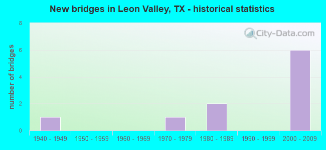
- New bridges - historical statistics
- 11940-1949
- 11970-1979
- 21980-1989
- 62000-2009

- Reconstructed bridges - Historical Statistics
- 11970-1979
- 01980-1989
- 11990-1999


- Bridge Condition - Superstructure
- 20.0%Very good
- 80.0%Good

- Bridge Condition - Substructure
- 60.0%Good
- 40.0%Satisfactory

- Bridge Condition - Channel
- 75.0%Good
- 25.0%Satisfactory

- Bridge Condition - Culverts
- 50.0%Good
- 50.0%Satisfactory
Find on map >> Show street view
Structure Number: 150150029110069, Location: 1.00 MI NW OF IH 410 (Lat: 29.492069, Lng: -98.614522), Route carried "on" structure: State highway 16, Year Built: 1948, Year Reconstructed: 1975, Status: Open, Structure Length: 3.05m (10.01ft), Average Daily Traffic: 19,020 (year 2013), Truck Traffic: 3%, Average Future Daily Traffic: 26,630 (year 2033), Design Load: H 20, Features Intersected: HUEBNER CREEK
Minimum Vertical Clearance: 30+ m (98+ ft), Kilometerpoint: 14.386, Lanes on structure: 3, Owner: State Highway Agency, Approaching Roadway Width: 12.2m (40.0ft), Skew: 3 degrees, Material/Design: Concrete, Design/Construction: Slab, Number Of Spans In Main Unit: 4, Length of Maximum Span: 7.6m (24.9ft), Curb or Sidewalk Widths: Left: 0.0m, Right: 1.5m (4.9ft), Curb-To-Curb Width: 12.8m (42.0ft), Out-to-Out Width: 13.5m (44.3ft)
Condition: Deck: Good, Superstructure: Good, Substructure: Satisfactory, Channel: Good, Operating Rating: 45.4 metric tons, Method Used To Determine Operating Rating: Load Factor (LF), Inventory Rating: 27.2 metric tons, Method Used To Determine Inventory Rating: Load Factor (LF), Structural Evaluation: Equal to present minimum criteria, Deck Geometry: Meets minimum limits, Waterway Adequacy: Equal to present minimum criteria, Approach Roadway Alignment: Equal to present desirable criteria, Designated Inspection Frequency: Every 24 months, Inspection Date: June 2020, Deck Structure Type: Concrete Cast-file-Place, Wearing Surface/Protective System: Wearing Surface: Bituminous
Find on map >> Show street view
Structure Number: 150150029110087, Location: 1.0 Mi NW of IH 410 (Lat: 29.492206, Lng: -98.614250), Route carried "on" structure: State highway 16, Year Built: 1975, Status: Open, Structure Length: 3.81m (12.50ft), Average Daily Traffic: 19,020 (year 2013), Truck Traffic: 3%, Average Future Daily Traffic: 26,630 (year 2033), Design Load: HS 20, Features Intersected: Huebner Creek
Minimum Vertical Clearance: 30+ m (98+ ft), Kilometerpoint: 14.368, Lanes on structure: 3, Owner: State Highway Agency, Approaching Roadway Width: 12.2m (40.0ft), Skew: 3 degrees, Material/Design: Concrete, Design/Construction: Slab, Number Of Spans In Main Unit: 5, Length of Maximum Span: 7.6m (24.9ft), Curb-To-Curb Width: 12.8m (42.0ft), Out-to-Out Width: 13.5m (44.3ft)
Condition: Deck: Good, Superstructure: Good, Substructure: Satisfactory, Channel: Good, Operating Rating: 68.0 metric tons, Method Used To Determine Operating Rating: Load Factor (LF), Inventory Rating: 40.8 metric tons, Method Used To Determine Inventory Rating: Load Factor (LF), Structural Evaluation: Equal to present minimum criteria, Deck Geometry: Meets minimum limits, Waterway Adequacy: Equal to present minimum criteria, Approach Roadway Alignment: Equal to present desirable criteria, Designated Inspection Frequency: Every 24 months, Inspection Date: June 2020, Deck Structure Type: Concrete Cast-file-Place, Wearing Surface/Protective System: Wearing Surface: Bituminous
Find on map >> Show street view
Structure Number: 150150029110187, Location: 0.2 Mi SE of IH 410 (Lat: 29.481386, Lng: -98.596917), Route carried "on" structure: State highway 421, Year Built: 1981, Year Reconstructed: 2002, Status: Open, Structure Length: 2.16m (7.09ft), Average Daily Traffic: 28,144 (year 2020), Truck Traffic: 7%, Average Future Daily Traffic: 41,390 (year 2033), Design Load: HS 20, Features Intersected: Zarzamora Creek
Minimum Vertical Clearance: 30+ m (98+ ft), Kilometerpoint: 16.472, Lanes on structure: 7, Owner: State Highway Agency, Approaching Roadway Width: 25.3m (83.0ft), Material/Design: Concrete, Design/Construction: Culvert, Number Of Spans In Main Unit: 6, Length of Maximum Span: 3.0m (9.8ft), Curb or Sidewalk Widths: Left: 2.1m (6.9ft), Right: 2.1m (6.9ft), Curb-To-Curb Width: 25.1m (82.3ft), Out-to-Out Width: 30.1m (98.8ft)
Condition: Channel: Good, Culverts: Good, Operating Rating: 39.9 metric tons, Method Used To Determine Operating Rating: Load Factor (LF), Inventory Rating: 23.6 metric tons, Method Used To Determine Inventory Rating: Load Factor (LF), Structural Evaluation: Somewhat better than minimum adequacy, Deck Geometry: High priority of replacement, Waterway Adequacy: Equal to present minimum criteria, Approach Roadway Alignment: Equal to present desirable criteria, Length Of Structure Improvement: 2.16m (7.09ft), Designated Inspection Frequency: Every 48 months, Inspection Date: August 2018, Bridge Improvement Cost: $12,000, Roadway Improvement Cost: $3,000, Total Project Cost: $15,000, Deck Structure Type: Concrete Cast-file-Place, Wearing Surface/Protective System: Wearing Surface: Bituminous
Find on map >> Show street view
Structure Number: 15015005210429, Location: 3.6 Mi SW of IH 10 (Lat: 29.482467, Lng: -98.600267), Route carried "on" structure: Interstate 410, Year Built: 2008, Status: Open, Structure Length: 10.79m (35.40ft), Average Daily Traffic: 172,438 (year 2020), Truck Traffic: 4%, Average Future Daily Traffic: 251,240 (year 2033), Design Load: HS 20, Features Intersected: SH 16 / LP 421
Minimum Vertical Clearance: 6.10m (20.01ft), Kilometerpoint: 21.641, Lanes on structure: 8, Lanes under structure: 8, Owner: State Highway Agency, Approaching Roadway Width: 38.7m (127.0ft), Skew: 34 degrees, Material/Design: Prestressed concrete, Design/Construction: Stringer/Multi-beam, Number Of Spans In Main Unit: 4, Length of Maximum Span: 29.3m (96.1ft), Curb-To-Curb Width: 38.8m (127.3ft), Out-to-Out Width: 40.2m (131.9ft)
Condition: Deck: Good, Superstructure: Good, Substructure: Good, Operating Rating: 54.4 metric tons, Method Used To Determine Operating Rating: Assigned rating based on Load Factor Design (LFD) reported in metric tons, Inventory Rating: 32.7 metric tons, Method Used To Determine Inventory Rating: Assigned rating based on Load Factor Design (LFD) reported in metric tons, Structural Evaluation: Better than present minimum criteria, Deck Geometry: Superior to present desirable criteria, Underclear: Equal to present minimum criteria, Approach Roadway Alignment: Equal to present desirable criteria, Designated Inspection Frequency: Every 24 months, Inspection Date: June 2020, Deck Structure Type: Concrete Precast Panels
Find on map >> Show street view
Structure Number: 150150052104292, Location: 0.2 Mi NW of IH 410 (Lat: 29.486342, Lng: -98.607194), Route carried "on" structure: State highway 16, Year Built: 2009, Status: Open, Structure Length: 38.47m (126.21ft), Average Daily Traffic: 34,975 (year 2020), Truck Traffic: 3%, Average Future Daily Traffic: 26,630 (year 2033), Design Load: HS 20, Features Intersected: Wurzbach Rd
Minimum Vertical Clearance: 30+ m (98+ ft), Kilometerpoint: 16.486, Lanes on structure: 2, Lanes under structure: 13, Owner: State Highway Agency, Approaching Roadway Width: 17.7m (58.1ft), Skew: 30 degrees, Material/Design: Steel, Design/Construction: Stringer/Multi-beam, Number Of Spans In Main Unit: 1, Number Of Approach Spans: 9, Length of Maximum Span: 48.8m (160.1ft), Curb-To-Curb Width: 17.7m (58.1ft), Out-to-Out Width: 18.9m (62.0ft)
Condition: Deck: Good, Superstructure: Good, Substructure: Good, Operating Rating: 54.4 metric tons, Method Used To Determine Operating Rating: Assigned rating based on Load Factor Design (LFD) reported in metric tons, Inventory Rating: 32.7 metric tons, Method Used To Determine Inventory Rating: Assigned rating based on Load Factor Design (LFD) reported in metric tons, Structural Evaluation: Better than present minimum criteria, Deck Geometry: Superior to present desirable criteria, Underclear: Superior to present desirable criteria, Approach Roadway Alignment: Equal to present desirable criteria, Designated Inspection Frequency: Every 24 months, Inspection Date: June 2020, Deck Structure Type: Concrete Cast-file-Place
Find on map >> Show street view
Structure Number: 150150052104293, Location: IH 410/ SH 16 Interchange (Lat: 29.484044, Lng: -98.604072), Route carried "on" structure: Ramp State highway 16, Year Built: 2009, Status: Open, Structure Length: 185.75m (609.42ft), Average Daily Traffic: 41,000 (year 2016), Truck Traffic: 3%, Average Future Daily Traffic: 57,400 (year 2036), Design Load: HS 20, Features Intersected: IH 410 etc
Minimum Vertical Clearance: 30+ m (98+ ft), Kilometerpoint: 16.084, Lanes on structure: 1, Lanes under structure: 23, Owner: State Highway Agency, Approaching Roadway Width: 8.5m (27.9ft), Skew: 9 degrees, Material/Design: Steel continuous, Design/Construction: Stringer/Multi-beam, Number Of Spans In Main Unit: 9, Number Of Approach Spans: 35, Length of Maximum Span: 70.1m (230.0ft), Curb-To-Curb Width: 8.4m (27.6ft), Out-to-Out Width: 9.1m (29.9ft)
Condition: Deck: Good, Superstructure: Very good, Substructure: Good, Operating Rating: 54.4 metric tons, Method Used To Determine Operating Rating: Assigned rating based on Load Factor Design (LFD) reported in metric tons, Inventory Rating: 32.7 metric tons, Method Used To Determine Inventory Rating: Assigned rating based on Load Factor Design (LFD) reported in metric tons, Structural Evaluation: Better than present minimum criteria, Deck Geometry: Superior to present desirable criteria, Underclear: Meets minimum limits, Approach Roadway Alignment: Equal to present desirable criteria, Designated Inspection Frequency: Every 24 months, Inspection Date: June 2020, Deck Structure Type: Concrete Cast-file-Place
Find on map >> Show street view
Structure Number: 150150084901015, Location: 0.50 Mi SW of SH 16 (Lat: 29.489169, Lng: -98.622842), Route carried "on" structure: State highway 471, Year Built: 1986, Status: Open, Structure Length: 1.10m (3.61ft), Average Daily Traffic: 18,674 (year 2015), Truck Traffic: 5%, Average Future Daily Traffic: 37,760 (year 2033), Design Load: HS 20, Features Intersected: Drain
Minimum Vertical Clearance: 30+ m (98+ ft), Kilometerpoint: 19.879, Lanes on structure: 5, Owner: State Highway Agency, Approaching Roadway Width: 20.1m (65.9ft), Skew: 4 degrees, Material/Design: Concrete, Design/Construction: Culvert, Number Of Spans In Main Unit: 3, Length of Maximum Span: 3.0m (9.8ft), Curb or Sidewalk Widths: Left: 1.5m (4.9ft), Right: 1.5m (4.9ft)
Condition: Channel: Satisfactory, Culverts: Satisfactory, Operating Rating: 39.9 metric tons, Method Used To Determine Operating Rating: Load Factor (LF), Inventory Rating: 23.6 metric tons, Method Used To Determine Inventory Rating: Load Factor (LF), Structural Evaluation: Somewhat better than minimum adequacy, Waterway Adequacy: Equal to present minimum criteria, Approach Roadway Alignment: Equal to present desirable criteria, Designated Inspection Frequency: Every 48 months, Inspection Date: June 2018
Find on map >> Show street view
Structure Number: 15015005210429, Location: 3.6 Mi SW of IH 10 (Lat: 29.482467, Lng: -98.600267), Route carried "under" structure: State highway 16, Year Built: 2008, Structure Length: 0. m, Average Daily Traffic: 38,040 (year 2013), Truck Traffic: 3%, Features Intersected: SH 16 / LP 421, Facility Carried by Structure: IH 410
Minimum Vertical Clearance: 5.69m (18.67ft), Kilometerpoint: 16.084, Lanes on structure: 8, Lanes under structure: 8, Material/Design: Prestressed concrete, Design/Construction: Stringer/Multi-beam, Length of Maximum Span: 29.3m (96.1ft)
Find on map >> Show street view
Structure Number: 150150052104292, Location: 0.2 Mi NW of IH 410 (Lat: 29.486342, Lng: -98.607194), Route carried "under" structure: City street , Year Built: 2009, Structure Length: 0. m, Average Daily Traffic: 41,000 (year 2014), Truck Traffic: 1%, Features Intersected: Wurzbach Rd, Facility Carried by Structure: SH16 to IH410 Conn
Minimum Vertical Clearance: 6.38m (20.93ft), Kilometerpoint: 0.402, Lanes on structure: 2, Lanes under structure: 13, Material/Design: Steel, Design/Construction: Stringer/Multi-beam, Length of Maximum Span: 48.8m (160.1ft)
Find on map >> Show street view
Structure Number: 150150052104293, Location: IH 410/ SH 16 Interchange (Lat: 29.484044, Lng: -98.604072), Route carried "under" structure: Interstate 410, Year Built: 2009, Structure Length: 0. m, Average Daily Traffic: 128,780 (year 2016), Truck Traffic: 5%, Features Intersected: IH 410 etc
Minimum Vertical Clearance: 7.16m (23.49ft), Kilometerpoint: 22.108, Lanes under structure: 23, Material/Design: Steel continuous, Design/Construction: Stringer/Multi-beam, Length of Maximum Span: 70.1m (230.0ft)