Bridge Statistics for Middle River, Maryland (MD)
Condition, Traffic, Stress, Structural Evaluation, Project Costs
- National Bridge Inventory (NBI) Statistics
- 34Number of bridges
- 482ft / 147mTotal length
- $2,834,000Total costs
- 737,558Total average daily traffic
- 50,874Total average daily truck traffic
- National Bridge Inventory (NBI) Registered Bridges for Middle River
- No street view available for this location
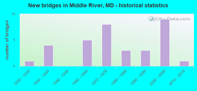
- New bridges - historical statistics
- 11930-1939
- 41940-1949
- 51960-1969
- 81970-1979
- 31980-1989
- 31990-1999
- 92000-2009
- 12010-2019
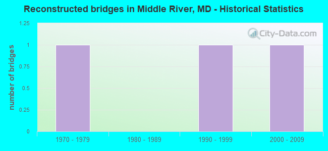
- Reconstructed bridges - Historical Statistics
- 11970-1979
- 01980-1989
- 11990-1999
- 12000-2009
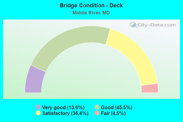
- Bridge Condition - Deck
- 13.6%Very good
- 45.5%Good
- 36.4%Satisfactory
- 4.5%Fair
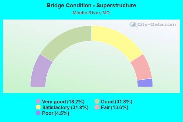
- Bridge Condition - Superstructure
- 18.2%Very good
- 31.8%Good
- 31.8%Satisfactory
- 13.6%Fair
- 4.5%Poor
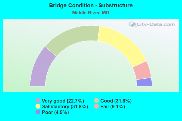
- Bridge Condition - Substructure
- 22.7%Very good
- 31.8%Good
- 31.8%Satisfactory
- 9.1%Fair
- 4.5%Poor
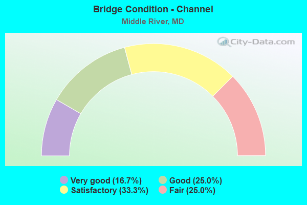
- Bridge Condition - Channel
- 16.7%Very good
- 25.0%Good
- 33.3%Satisfactory
- 25.0%Fair
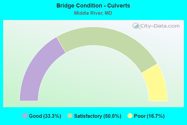
- Bridge Condition - Culverts
- 33.3%Good
- 50.0%Satisfactory
- 16.7%Poor
Find on map >> Show street view
Structure Number: 10000003001501, Location: 0.2 M E OF CAMPBELL BL'VD (Lat: 39.370656, Lng: -76.445978), Route carried "on" structure: State highway 7, Year Built: 2002, Status: Open, Structure Length: 3.35m (10.99ft), Average Daily Traffic: 16,450 (year 2009), Truck Traffic: 8%, Average Future Daily Traffic: 19,636 (year 2026), Design Load: HS 25 or greater, Features Intersected: WHITEMARSH RUN
Minimum Vertical Clearance: 30+ m (98+ ft), Kilometerpoint: 9.718, Lanes on structure: 4, Owner: State Highway Agency, Approaching Roadway Width: 23.8m (78.1ft), Material/Design: Prestressed concrete continuous, Design/Construction: Slab, Number Of Spans In Main Unit: 2, Length of Maximum Span: 16.8m (55.1ft), Curb or Sidewalk Widths: Left: 1.6m (5.2ft), Right: 1.6m (5.2ft), Curb-To-Curb Width: 19.8m (65.0ft), Out-to-Out Width: 23.8m (78.1ft)
Condition: Deck: Good, Superstructure: Good, Substructure: Good, Channel: Very good, Inventory Rating: 76.2 metric tons, Method Used To Determine Inventory Rating: Load Factor (LF), Structural Evaluation: Better than present minimum criteria, Deck Geometry: Better than present minimum criteria, Waterway Adequacy: Equal to present desirable criteria, Approach Roadway Alignment: Equal to present desirable criteria, Designated Inspection Frequency: Every 24 months, Inspection Date: May 2021, Deck Structure Type: Concrete Cast-file-Place, Wearing Surface/Protective System: Wearing Surface: Integral Concrete, Deck Protection: Epoxy Coated Reinforcing
Find on map >> Show street view
Structure Number: 10000003003801, Location: 0.45 MI W OF MD 700 (Lat: 39.339547, Lng: -76.475381), Route carried "on" structure: US 40, Year Built: 1990, Status: Open, Structure Length: 8.14m (26.71ft), Average Daily Traffic: 47,120 (year 0009), Truck Traffic: 8%, Average Future Daily Traffic: 56,901 (year 0026), Design Load: HS 20, Features Intersected: CSX TRANSPORTATION
Minimum Vertical Clearance: 30+ m (98+ ft), Kilometerpoint: 28.415, Lanes on structure: 6, Base Highway Network: Yes, Owner: State Highway Agency, Approaching Roadway Width: 28.7m (94.2ft), Skew: 25 degrees, Material/Design: Steel continuous, Design/Construction: Stringer/Multi-beam, Number Of Spans In Main Unit: 3, Length of Maximum Span: 32.0m (105.0ft), Curb-To-Curb Width: 28.7m (94.2ft), Out-to-Out Width: 29.6m (97.1ft)
Condition: Deck: Good, Superstructure: Satisfactory, Substructure: Good, Operating Rating: 73.9 metric tons, Method Used To Determine Operating Rating: Load Factor (LF), Inventory Rating: 44.4 metric tons, Method Used To Determine Inventory Rating: Load Factor (LF), Structural Evaluation: Equal to present minimum criteria, Deck Geometry: Superior to present desirable criteria, Underclear: Meets minimum limits, Approach Roadway Alignment: Equal to present desirable criteria, Designated Inspection Frequency: Every 24 months, Inspection Date: June 2020, Deck Structure Type: Concrete Cast-file-Place, Wearing Surface/Protective System: Wearing Surface: Monolithic Concrete, Deck Protection: Epoxy Coated Reinforcing
Find on map >> Show street view
Structure Number: 10000003003901, Location: 0.39 MILES EAST OF I-695 (Lat: 39.336183, Lng: -76.482792), Route carried "on" structure: US 40, Year Built: 1935, Year Reconstructed: 1996, Status: Open, Structure Length: 1.25m (4.10ft), Average Daily Traffic: 54,850 (year 2009), Truck Traffic: 8%, Average Future Daily Traffic: 62,527 (year 2026), Design Load: HS 25 or greater, Features Intersected: STEMMERS RUN
Minimum Vertical Clearance: 30+ m (98+ ft), Kilometerpoint: 27.602, Lanes on structure: 9, Base Highway Network: Yes, Owner: State Highway Agency, Approaching Roadway Width: 40.2m (131.9ft), Skew: 36 degrees, Material/Design: Prestressed concrete, Design/Construction: Slab, Number Of Spans In Main Unit: 1, Length of Maximum Span: 12.5m (41.0ft), Curb or Sidewalk Widths: Left: 1.6m (5.2ft), Right: 1.6m (5.2ft), Curb-To-Curb Width: 34.1m (111.9ft), Out-to-Out Width: 38.5m (126.3ft)
Condition: Deck: Satisfactory, Superstructure: Good, Substructure: Satisfactory, Channel: Satisfactory, Operating Rating: 65.3 metric tons, Method Used To Determine Operating Rating: Load Factor (LF), Inventory Rating: 39.0 metric tons, Method Used To Determine Inventory Rating: Load Factor (LF), Structural Evaluation: Equal to present minimum criteria, Deck Geometry: Somewhat better than minimum adequacy, Waterway Adequacy: Equal to present minimum criteria, Approach Roadway Alignment: Equal to present desirable criteria, Designated Inspection Frequency: Every 24 months, Inspection Date: December 2020, Deck Structure Type: Concrete Precast Panels, Wearing Surface/Protective System: Wearing Surface: Integral Concrete, Deck Protection: Epoxy Coated Reinforcing
Find on map >> Show street view
Structure Number: 10000003009501, Location: 0.55 MI W OF MD 587 (Lat: 39.331353, Lng: -76.437872), Route carried "on" structure: State highway 150, Year Built: 1942, Year Reconstructed: 2014, Status: Open, Structure Length: 4.33m (14.21ft), Average Daily Traffic: 35,131 (year 2013), Truck Traffic: 8%, Average Future Daily Traffic: 42,000 (year 2028), Features Intersected: MD 700
Minimum Vertical Clearance: 30+ m (98+ ft), Kilometerpoint: 9.509, Lanes on structure: 6, Lanes under structure: 5, Base Highway Network: Yes, Owner: State Highway Agency, Approaching Roadway Width: 23.8m (78.1ft), Skew: 20 degrees, Material/Design: Steel, Design/Construction: Stringer/Multi-beam, Number Of Spans In Main Unit: 2, Length of Maximum Span: 21.0m (68.9ft), Curb or Sidewalk Widths: Left: 1.7m (5.6ft), Right: 1.7m (5.6ft), Curb-To-Curb Width: 23.8m (78.1ft), Out-to-Out Width: 29.8m (97.8ft)
Condition: Deck: Good, Superstructure: Fair, Substructure: Satisfactory, Inventory Rating: 54.4 metric tons, Method Used To Determine Inventory Rating: Load Factor (LF), Structural Evaluation: Somewhat better than minimum adequacy, Deck Geometry: Somewhat better than minimum adequacy, Underclear: High priority of replacement, Approach Roadway Alignment: Equal to present desirable criteria, Designated Inspection Frequency: Every 24 months, Other Special Inspection Frequency: Every 12 months, Inspection Date: July 2020, Other Special Inspection Date: July 2021, Deck Structure Type: Concrete Cast-file-Place, Wearing Surface/Protective System: Wearing Surface: Monolithic Concrete
Find on map >> Show street view
Structure Number: 10000003010601, Location: 1.89 MI N OF MD 150 (Lat: 39.342742, Lng: -76.467572), Route carried "on" structure: State highway 700, Year Built: 1941, Year Reconstructed: 1984, Status: Open, Structure Length: 6.77m (22.21ft), Average Daily Traffic: 8,661 (year 2009), Truck Traffic: 8%, Average Future Daily Traffic: 15,284 (year 2026), Design Load: HS 20, Features Intersected: US 40
Minimum Vertical Clearance: 30+ m (98+ ft), Kilometerpoint: 3.170, Lanes on structure: 1, Lanes under structure: 5, Owner: State Highway Agency, Approaching Roadway Width: 10.1m (33.1ft), Material/Design: Steel, Design/Construction: Stringer/Multi-beam, Number Of Spans In Main Unit: 4, Length of Maximum Span: 21.9m (71.9ft), Curb-To-Curb Width: 9.7m (31.8ft), Out-to-Out Width: 10.6m (34.8ft)
Condition: Deck: Satisfactory, Superstructure: Fair, Substructure: Good, Inventory Rating: 69.8 metric tons, Method Used To Determine Inventory Rating: Load Factor (LF), Structural Evaluation: Somewhat better than minimum adequacy, Deck Geometry: Meets minimum limits, Underclear: Equal to present minimum criteria, Approach Roadway Alignment: Equal to present minimum criteria, Length Of Structure Improvement: 6.77m (22.21ft), Designated Inspection Frequency: Every 24 months, Inspection Date: May 2021, Bridge Improvement Cost: $464,000, Roadway Improvement Cost: $46,000, Total Project Cost: $510,000, Deck Structure Type: Concrete Cast-file-Place, Wearing Surface/Protective System: Wearing Surface: Monolithic Concrete, Deck Protection: Epoxy Coated Reinforcing
Find on map >> Show street view
Structure Number: 100000030216014, Location: 0.39 MILE EAST OF MD 7 (Lat: 39.374042, Lng: -76.432156), Route carried "on" structure: State highway 43, Year Built: 2005, Status: Open, Structure Length: 7.83m (25.69ft), Average Daily Traffic: 26,807 (year 2018), Truck Traffic: 10%, Average Future Daily Traffic: 26,839 (year 2038), Design Load: HS 25 or greater, Features Intersected: US 40
Minimum Vertical Clearance: 30+ m (98+ ft), Kilometerpoint: 8.245, Lanes on structure: 2, Lanes under structure: 5, Owner: State Highway Agency, Approaching Roadway Width: 12.2m (40.0ft), Skew: 1 degrees, Material/Design: Concrete continuous, Design/Construction: Stringer/Multi-beam, Number Of Spans In Main Unit: 2, Length of Maximum Span: 38.1m (125.0ft), Curb-To-Curb Width: 12.0m (39.4ft), Out-to-Out Width: 13.3m (43.6ft)
Condition: Deck: Good, Superstructure: Very good, Substructure: Good, Operating Rating: 80.7 metric tons, Method Used To Determine Operating Rating: Load Factor (LF), Inventory Rating: 50.8 metric tons, Method Used To Determine Inventory Rating: Load Factor (LF), Structural Evaluation: Better than present minimum criteria, Deck Geometry: Equal to present minimum criteria, Underclear: Meets minimum limits, Approach Roadway Alignment: Equal to present desirable criteria, Designated Inspection Frequency: Every 24 months, Inspection Date: June 2020, Deck Structure Type: Concrete Cast-file-Place, Wearing Surface/Protective System: Wearing Surface: Integral Concrete, Deck Protection: Epoxy Coated Reinforcing
Find on map >> Show street view
Structure Number: 100000030251015, Location: 0.02 MILE SOUTH OF MD 702 (Lat: 39.328625, Lng: -76.484256), Route carried "on" structure: State highway 695, Year Built: 1969, Status: Open, Structure Length: 2.65m (8.69ft), Average Daily Traffic: 96,082 (year 2009), Truck Traffic: 8%, Average Future Daily Traffic: 57,230 (year 2026), Design Load: HS 20, Features Intersected: KELSO DRIVE
Minimum Vertical Clearance: 30+ m (98+ ft), Kilometerpoint: 2.175, Lanes on structure: 4, Lanes under structure: 4, Base Highway Network: Yes, Owner: State Highway Agency, Approaching Roadway Width: 11.6m (38.1ft), Material/Design: Steel, Design/Construction: Stringer/Multi-beam, Number Of Spans In Main Unit: 1, Length of Maximum Span: 25.3m (83.0ft), Curb-To-Curb Width: 20.3m (66.6ft), Out-to-Out Width: 21.2m (69.6ft)
Condition: Deck: Good, Superstructure: Satisfactory, Substructure: Satisfactory, Operating Rating: 62.6 metric tons, Method Used To Determine Operating Rating: Load Factor (LF), Inventory Rating: 37.2 metric tons, Method Used To Determine Inventory Rating: Load Factor (LF), Structural Evaluation: Equal to present minimum criteria, Deck Geometry: Equal to present minimum criteria, Underclear: Meets minimum limits, Approach Roadway Alignment: Equal to present desirable criteria, Designated Inspection Frequency: Every 24 months, Inspection Date: October 2020, Deck Structure Type: Concrete Cast-file-Place, Wearing Surface/Protective System: Wearing Surface: Monolithic Concrete
Find on map >> Show street view
Structure Number: 100000030251016, Location: 0.02 MILE SOUTH OF MD 702 (Lat: 39.328633, Lng: -76.483772), Route carried "on" structure: State highway 695, Year Built: 1969, Status: Open, Structure Length: 2.65m (8.69ft), Average Daily Traffic: 96,082 (year 2009), Truck Traffic: 8%, Average Future Daily Traffic: 57,230 (year 2026), Design Load: HS 20, Features Intersected: KELSO DRIVE
Minimum Vertical Clearance: 30+ m (98+ ft), Kilometerpoint: 2.175, Lanes on structure: 4, Lanes under structure: 4, Base Highway Network: Yes, Owner: State Highway Agency, Approaching Roadway Width: 11.6m (38.1ft), Material/Design: Steel, Design/Construction: Stringer/Multi-beam, Number Of Spans In Main Unit: 1, Length of Maximum Span: 25.3m (83.0ft), Curb-To-Curb Width: 19.4m (63.6ft), Out-to-Out Width: 20.3m (66.6ft)
Condition: Deck: Satisfactory, Superstructure: Satisfactory, Substructure: Satisfactory, Operating Rating: 88.0 metric tons, Method Used To Determine Operating Rating: Load Factor (LF), Inventory Rating: 52.6 metric tons, Method Used To Determine Inventory Rating: Load Factor (LF), Structural Evaluation: Equal to present minimum criteria, Deck Geometry: Somewhat better than minimum adequacy, Underclear: Meets minimum limits, Approach Roadway Alignment: Equal to present desirable criteria, Designated Inspection Frequency: Every 24 months, Inspection Date: October 2020, Deck Structure Type: Concrete Cast-file-Place, Wearing Surface/Protective System: Wearing Surface: Monolithic Concrete
Find on map >> Show street view
Structure Number: 100000030267014, Location: 0.20 MI E OF MD 695 (Lat: 39.325683, Lng: -76.480658), Route carried "on" structure: State highway 702, Year Built: 1972, Status: Open, Structure Length: 14.26m (46.78ft), Average Daily Traffic: 19,406 (year 2012), Truck Traffic: 8%, Average Future Daily Traffic: 23,287 (year 2032), Design Load: HS 20, Features Intersected: AMTRAK & 695 RMP '7'
Minimum Vertical Clearance: 30+ m (98+ ft), Kilometerpoint: 0.257, Lanes on structure: 1, Lanes under structure: 1, Base Highway Network: Yes, Owner: State Highway Agency, Approaching Roadway Width: 11.6m (38.1ft), Skew: 9 degrees, Material/Design: Steel continuous, Design/Construction: Stringer/Multi-beam, Number Of Spans In Main Unit: 5, Number Of Approach Spans: 2, Length of Maximum Span: 25.0m (82.0ft), Curb-To-Curb Width: 15.7m (51.5ft), Out-to-Out Width: 16.7m (54.8ft)
Condition: Deck: Good, Superstructure: Good, Substructure: Satisfactory, Operating Rating: 73.9 metric tons, Method Used To Determine Operating Rating: Load Factor (LF), Inventory Rating: 44.4 metric tons, Method Used To Determine Inventory Rating: Load Factor (LF), Structural Evaluation: Equal to present minimum criteria, Deck Geometry: Superior to present desirable criteria, Underclear: Somewhat better than minimum adequacy, Approach Roadway Alignment: Equal to present desirable criteria, Designated Inspection Frequency: Every 24 months, Inspection Date: October 2020, Deck Structure Type: Concrete Cast-file-Place, Wearing Surface/Protective System: Wearing Surface: Latex Concrete
Find on map >> Show street view
Structure Number: 10000003028301, Location: 0.08 MI N OF US 40 (Lat: 39.326489, Lng: -76.480381), Route carried "on" structure: Ramp State highway 695, Year Built: 1973, Status: Open, Structure Length: 9.54m (31.30ft), Average Daily Traffic: 36,361 (year 2006), Truck Traffic: 8%, Average Future Daily Traffic: 39,270 (year 2026), Design Load: HS 20, Features Intersected: AMTRAK
Minimum Vertical Clearance: 30+ m (98+ ft), Kilometerpoint: 1.818, Lanes on structure: 2, Base Highway Network: Yes, Owner: State Highway Agency, Approaching Roadway Width: 9.4m (30.8ft), Skew: 3 degrees, Material/Design: Steel continuous, Design/Construction: Stringer/Multi-beam, Number Of Spans In Main Unit: 2, Number Of Approach Spans: 2, Length of Maximum Span: 30.5m (100.1ft), Curb-To-Curb Width: 9.3m (30.5ft), Out-to-Out Width: 10.3m (33.8ft)
Condition: Deck: Good, Superstructure: Satisfactory, Substructure: Fair, Operating Rating: 73.0 metric tons, Method Used To Determine Operating Rating: Load Factor (LF), Inventory Rating: 43.5 metric tons, Method Used To Determine Inventory Rating: Load Factor (LF), Structural Evaluation: Somewhat better than minimum adequacy, Deck Geometry: Somewhat better than minimum adequacy, Underclear: Better than present minimum criteria, Approach Roadway Alignment: Equal to present desirable criteria, Designated Inspection Frequency: Every 24 months, Inspection Date: September 2020, Deck Structure Type: Concrete Cast-file-Place, Wearing Surface/Protective System: Wearing Surface: Latex Concrete
Find on map >> Show street view
Structure Number: 10000003029601, Location: 0.10 MI S OF US 40 (Lat: 39.331322, Lng: -76.486144), Route carried "on" structure: Ramp State highway 695, Year Built: 1975, Status: Open, Structure Length: 5.88m (19.29ft), Average Daily Traffic: 6,742 (year 2018), Truck Traffic: 8%, Average Future Daily Traffic: 6,750 (year 2038), Design Load: HS 20, Features Intersected: CSX TRANSPORTATION
Minimum Vertical Clearance: 30+ m (98+ ft), Kilometerpoint: 0.191, Lanes on structure: 1, Base Highway Network: Yes, Owner: State Highway Agency, Approaching Roadway Width: 8.8m (28.9ft), Skew: 2 degrees, Material/Design: Steel, Design/Construction: Stringer/Multi-beam, Number Of Spans In Main Unit: 3, Length of Maximum Span: 23.5m (77.1ft), Curb-To-Curb Width: 9.3m (30.5ft), Out-to-Out Width: 10.3m (33.8ft)
Condition: Deck: Satisfactory, Superstructure: Satisfactory, Substructure: Good, Inventory Rating: 55.8 metric tons, Method Used To Determine Inventory Rating: Load Factor (LF), Structural Evaluation: Equal to present minimum criteria, Deck Geometry: Superior to present desirable criteria, Underclear: Somewhat better than minimum adequacy, Approach Roadway Alignment: Equal to present desirable criteria, Length Of Structure Improvement: 5.88m (19.29ft), Designated Inspection Frequency: Every 24 months, Inspection Date: August 2021, Bridge Improvement Cost: $390,000, Roadway Improvement Cost: $39,000, Total Project Cost: $429,000, Deck Structure Type: Concrete Cast-file-Place, Wearing Surface/Protective System: Wearing Surface: Monolithic Concrete
Find on map >> Show street view
Structure Number: 10000003036902, Location: RAMP TO MD 7 (Lat: 39.374053, Lng: -76.438747), Route carried "on" structure: Ramp State highway 43, Year Built: 1996, Status: Open, Structure Length: 0.63m (2.07ft), Average Daily Traffic: 7,440 (year 2006), Truck Traffic: 5%, Average Future Daily Traffic: 8,578 (year 2026), Design Load: HS 25 or greater, Features Intersected: TRIB TO WHITEMARSH RUN
Minimum Vertical Clearance: 30+ m (98+ ft), Kilometerpoint: 0.354, Lanes on structure: 4, Base Highway Network: Yes, Owner: State Highway Agency, Approaching Roadway Width: 11.9m (39.0ft), Skew: 3 degrees, Material/Design: Concrete, Design/Construction: Culvert, Length of Maximum Span: 3.0m (9.8ft), Curb-To-Curb Width: 21.0m (68.9ft), Out-to-Out Width: 25.8m (84.6ft)
Condition: Channel: Good, Culverts: Good, Operating Rating: 43.5 metric tons, Method Used To Determine Operating Rating: Field evaluation and documented engineering judgment, Inventory Rating: 43.5 metric tons, Method Used To Determine Inventory Rating: Field evaluation and documented engineering judgment, Structural Evaluation: Better than present minimum criteria, Deck Geometry: Superior to present desirable criteria, Waterway Adequacy: Equal to present desirable criteria, Approach Roadway Alignment: Equal to present desirable criteria, Designated Inspection Frequency: Every 24 months, Inspection Date: July 2021
Find on map >> Show street view
Structure Number: 10000003037101, Location: 0.197 MILE EAST OF US 40 (Lat: 39.372369, Lng: -76.430172), Route carried "on" structure: State highway 43, Year Built: 2004, Status: Open, Structure Length: 9.63m (31.59ft), Average Daily Traffic: 13,012 (year 2009), Truck Traffic: 10%, Average Future Daily Traffic: 18,679 (year 2026), Design Load: HS 25 or greater, Features Intersected: WHITE MARSH RUN
Minimum Vertical Clearance: 30+ m (98+ ft), Kilometerpoint: 8.603, Lanes on structure: 7, Base Highway Network: Yes, Owner: State Highway Agency, Approaching Roadway Width: 26.5m (86.9ft), Skew: 22 degrees, Material/Design: Prestressed concrete, Design/Construction: Stringer/Multi-beam, Number Of Spans In Main Unit: 3, Length of Maximum Span: 36.6m (120.1ft), Curb or Sidewalk Widths: Left: 1.6m (5.2ft), Right: 0.0m, Curb-To-Curb Width: 26.5m (86.9ft), Out-to-Out Width: 36.7m (120.4ft)
Condition: Deck: Very good, Superstructure: Good, Substructure: Very good, Channel: Fair, Operating Rating: 62.6 metric tons, Method Used To Determine Operating Rating: Load Factor (LF), Inventory Rating: 37.6 metric tons, Method Used To Determine Inventory Rating: Load Factor (LF), Structural Evaluation: Better than present minimum criteria, Deck Geometry: Meets minimum limits, Waterway Adequacy: Equal to present desirable criteria, Approach Roadway Alignment: Equal to present desirable criteria, Designated Inspection Frequency: Every 24 months, Inspection Date: May 2020, Deck Structure Type: Concrete Cast-file-Place, Wearing Surface/Protective System: Wearing Surface: Integral Concrete, Deck Protection: Epoxy Coated Reinforcing
Find on map >> Show street view
Structure Number: 10000003037201, Location: 0.939 MILE EAST OF US 40 (Lat: 39.363031, Lng: -76.424400), Route carried "on" structure: State highway 43, Year Built: 2005, Status: Open, Structure Length: 3.84m (12.60ft), Average Daily Traffic: 13,012 (year 2009), Truck Traffic: 10%, Average Future Daily Traffic: 18,679 (year 2026), Design Load: HS 25 or greater, Features Intersected: BIRD RIVER ROAD
Minimum Vertical Clearance: 30+ m (98+ ft), Kilometerpoint: 9.797, Lanes on structure: 4, Lanes under structure: 2, Base Highway Network: Yes, Owner: State Highway Agency, Approaching Roadway Width: 16.5m (54.1ft), Skew: 22 degrees, Material/Design: Prestressed concrete, Design/Construction: Stringer/Multi-beam, Number Of Spans In Main Unit: 1, Length of Maximum Span: 36.6m (120.1ft), Curb or Sidewalk Widths: Left: 1.6m (5.2ft), Right: 0.0m, Curb-To-Curb Width: 16.5m (54.1ft), Out-to-Out Width: 27.2m (89.2ft)
Condition: Deck: Good, Superstructure: Very good, Substructure: Very good, Inventory Rating: 35.4 metric tons, Method Used To Determine Inventory Rating: Load Factor (LF), Structural Evaluation: Equal to present desirable criteria, Deck Geometry: High priority of replacement, Underclear: Better than present minimum criteria, Approach Roadway Alignment: Equal to present desirable criteria, Designated Inspection Frequency: Every 24 months, Inspection Date: Febuary 2022, Deck Structure Type: Concrete Cast-file-Place, Wearing Surface/Protective System: Wearing Surface: Integral Concrete, Deck Protection: Epoxy Coated Reinforcing
Find on map >> Show street view
Structure Number: 10000003037301, Location: 1.587 MILE EAST OF US 40 (Lat: 39.361025, Lng: -76.412772), Route carried "on" structure: State highway 43, Year Built: 2005, Status: Open, Structure Length: 3.51m (11.52ft), Average Daily Traffic: 13,012 (year 2009), Truck Traffic: 10%, Average Future Daily Traffic: 18,679 (year 2026), Design Load: HS 25 or greater, Features Intersected: WINDLASS RUN
Minimum Vertical Clearance: 30+ m (98+ ft), Kilometerpoint: 10.840, Lanes on structure: 4, Base Highway Network: Yes, Owner: State Highway Agency, Approaching Roadway Width: 10.4m (34.1ft), Skew: 20 degrees, Material/Design: Prestressed concrete, Design/Construction: Stringer/Multi-beam, Number Of Spans In Main Unit: 1, Length of Maximum Span: 33.5m (109.9ft), Curb or Sidewalk Widths: Left: 1.6m (5.2ft), Right: 3.1m (10.2ft), Curb-To-Curb Width: 16.5m (54.1ft), Out-to-Out Width: 29.2m (95.8ft)
Condition: Deck: Very good, Superstructure: Very good, Substructure: Very good, Channel: Very good, Operating Rating: 60.8 metric tons, Method Used To Determine Operating Rating: Load Factor (LF), Inventory Rating: 36.3 metric tons, Method Used To Determine Inventory Rating: Load Factor (LF), Structural Evaluation: Equal to present desirable criteria, Deck Geometry: High priority of replacement, Waterway Adequacy: Equal to present desirable criteria, Approach Roadway Alignment: Equal to present desirable criteria, Designated Inspection Frequency: Every 24 months, Inspection Date: April 2020, Deck Structure Type: Concrete Cast-file-Place, Wearing Surface/Protective System: Wearing Surface: Integral Concrete, Deck Protection: Epoxy Coated Reinforcing
Find on map >> Show street view
Structure Number: 10000003037401, Location: 0.156 MILE WEST OF MD 150 (Lat: 39.339428, Lng: -76.417308), Route carried "on" structure: State highway 43, Year Built: 2006, Status: Open, Structure Length: 10.85m (35.60ft), Average Daily Traffic: 13,012 (year 2009), Truck Traffic: 10%, Average Future Daily Traffic: 18,679 (year 2026), Design Load: HS 20, Features Intersected: AMTRAK
Minimum Vertical Clearance: 30+ m (98+ ft), Kilometerpoint: 13.601, Lanes on structure: 4, Base Highway Network: Yes, Owner: State Highway Agency, Approaching Roadway Width: 25.9m (85.0ft), Skew: 24 degrees, Material/Design: Steel continuous, Design/Construction: Stringer/Multi-beam, Number Of Spans In Main Unit: 3, Length of Maximum Span: 47.9m (157.2ft), Curb or Sidewalk Widths: Left: 1.5m (4.9ft), Right: 3.0m (9.8ft), Curb-To-Curb Width: 16.5m (54.1ft), Out-to-Out Width: 26.8m (87.9ft)
Condition: Deck: Very good, Superstructure: Very good, Substructure: Very good, Operating Rating: 81.6 metric tons, Method Used To Determine Operating Rating: Load Factor (LF), Inventory Rating: 49.0 metric tons, Method Used To Determine Inventory Rating: Load Factor (LF), Structural Evaluation: Equal to present desirable criteria, Deck Geometry: Meets minimum limits, Underclear: Meets minimum limits, Approach Roadway Alignment: Equal to present desirable criteria, Designated Inspection Frequency: Every 24 months, Inspection Date: Febuary 2021, Deck Structure Type: Concrete Cast-file-Place, Wearing Surface/Protective System: Wearing Surface: Monolithic Concrete, Deck Protection: Epoxy Coated Reinforcing
Find on map >> Show street view
Structure Number: 10000003037503, Location: 0.9 M E OF BIRD RIVER RD (Lat: 39.357517, Lng: -76.408256), Route carried "on" structure: State highway 43, Year Built: 2005, Status: Open, Structure Length: 0.96m (3.15ft), Average Daily Traffic: 16,200 (year 2006), Truck Traffic: 10%, Average Future Daily Traffic: 18,679 (year 2026), Design Load: HS 25 or greater, Features Intersected: TRIB TO WINDLASS RUN
Minimum Vertical Clearance: 30+ m (98+ ft), Kilometerpoint: 11.247, Lanes on structure: 4, Base Highway Network: Yes, Owner: State Highway Agency, Approaching Roadway Width: 29.3m (96.1ft), Material/Design: Concrete, Design/Construction: Culvert, Number Of Spans In Main Unit: 3, Length of Maximum Span: 2.7m (8.9ft)
Condition: Channel: Satisfactory, Culverts: Good, Structural Evaluation: Better than present minimum criteria, Waterway Adequacy: Equal to present desirable criteria, Approach Roadway Alignment: Equal to present desirable criteria, Designated Inspection Frequency: Every 24 months, Inspection Date: November 2020
Find on map >> Show street view
Structure Number: 200000B-005001, Location: 2.4 MI E EASTERN AVE (Lat: 39.326914, Lng: -76.360992), Route carried "on" structure: County highway 4610, Year Built: 1960, Status: Closed, Structure Length: 7.32m (24.02ft), Truck Traffic: 5%, Design Load: HS 20, Features Intersected: SALTPETER CREEK, Facility Carried by Structure: CARROLL ISLAND ROA
Minimum Vertical Clearance: 30+ m (98+ ft), Kilometerpoint: 3.910, Lanes on structure: 2, Owner: County Highway Agency, Approaching Roadway Width: 7.9m (25.9ft), Material/Design: Prestressed concrete, Design/Construction: Box Beam or Girders - Multiple, Number Of Spans In Main Unit: 4, Length of Maximum Span: 18.3m (60.0ft), Curb or Sidewalk Widths: Left: 0.7m (2.3ft), Right: 0.7m (2.3ft), Curb-To-Curb Width: 7.9m (25.9ft), Out-to-Out Width: 9.6m (31.5ft)
Condition: Deck: Fair, Superstructure: Fair, Substructure: Fair, Channel: Good, Operating Rating: 88.0 metric tons, Method Used To Determine Operating Rating: Load Factor (LF), Inventory Rating: 52.6 metric tons, Method Used To Determine Inventory Rating: Load Factor (LF), Structural Evaluation: Somewhat better than minimum adequacy, Deck Geometry: Equal to present minimum criteria, Waterway Adequacy: Equal to present desirable criteria, Approach Roadway Alignment: Equal to present minimum criteria, Designated Inspection Frequency: Every 24 months, Underwater Inspection Frequency: Every 48 months, Inspection Date: December 2021, Underwater Inspection Date: December 2019, Wearing Surface/Protective System: Wearing Surface: Bituminous
Find on map >> Show street view
Structure Number: 200000B-007801, Location: 0.16 MI N OF MD RTE 150 (Lat: 39.345889, Lng: -76.394181), Route carried "on" structure: County highway 4158, Year Built: 2000, Status: Open, Structure Length: 6.25m (20.51ft), Average Daily Traffic: 3,515 (year 2012), Truck Traffic: 11%, Average Future Daily Traffic: 4,376 (year 2034), Design Load: HS 25 or greater, Features Intersected: AMTRAK RAILROAD, Facility Carried by Structure: EARLS ROAD
Minimum Vertical Clearance: 30+ m (98+ ft), Kilometerpoint: 0.257, Lanes on structure: 2, Owner: County Highway Agency, Approaching Roadway Width: 10.1m (33.1ft), Skew: 2 degrees, Material/Design: Steel continuous, Design/Construction: Stringer/Multi-beam, Number Of Spans In Main Unit: 3, Length of Maximum Span: 31.7m (104.0ft), Curb-To-Curb Width: 10.1m (33.1ft), Out-to-Out Width: 11.1m (36.4ft)
Condition: Deck: Good, Superstructure: Good, Substructure: Good, Inventory Rating: 69.4 metric tons, Method Used To Determine Inventory Rating: Load Factor (LF), Structural Evaluation: Better than present minimum criteria, Deck Geometry: Meets minimum limits, Underclear: Superior to present desirable criteria, Approach Roadway Alignment: Equal to present minimum criteria, Designated Inspection Frequency: Every 24 months, Inspection Date: April 2021, Deck Structure Type: Concrete Cast-file-Place, Wearing Surface/Protective System: Wearing Surface: Integral Concrete, Deck Protection: Epoxy Coated Reinforcing
Find on map >> Show street view
Structure Number: 200000B-013201, Location: 0.8 MI SE OF PULASKI HWY (Lat: 39.329261, Lng: -76.471050), Route carried "on" structure: County highway 4458, Year Built: 1971, Status: Open, Structure Length: 10.49m (34.42ft), Average Daily Traffic: 19,388 (year 2019), Truck Traffic: 5%, Average Future Daily Traffic: 28,810 (year 2039), Design Load: HS 20, Features Intersected: AMTRAK AND OREMS ROAD, Facility Carried by Structure: ROSSVILLE BOULEVAR
Minimum Vertical Clearance: 30+ m (98+ ft), Kilometerpoint: 6.854, Lanes on structure: 4, Lanes under structure: 2, Owner: County Highway Agency, Approaching Roadway Width: 15.2m (49.9ft), Skew: 24 degrees, Material/Design: Steel continuous, Design/Construction: Stringer/Multi-beam, Number Of Spans In Main Unit: 2, Number Of Approach Spans: 2, Length of Maximum Span: 33.8m (110.9ft), Curb or Sidewalk Widths: Left: 1.6m (5.2ft), Right: 1.6m (5.2ft), Curb-To-Curb Width: 15.2m (49.9ft), Out-to-Out Width: 23.8m (78.1ft)
Condition: Deck: Satisfactory, Superstructure: Poor, Substructure: Poor, Operating Rating: 56.7 metric tons, Method Used To Determine Operating Rating: Load Factor (LF), Inventory Rating: 34.0 metric tons, Method Used To Determine Inventory Rating: Load Factor (LF), Structural Evaluation: Meets minimum limits, Deck Geometry: High priority of corrective action, Underclear: High priority of corrective action, Approach Roadway Alignment: Equal to present minimum criteria, Length Of Structure Improvement: 10.49m (34.42ft), Designated Inspection Frequency: Every 24 months, Other Special Inspection Frequency: Every 12 months, Inspection Date: August 2021, Other Special Inspection Date: August 2021, Bridge Improvement Cost: $1,458,000, Roadway Improvement Cost: $437,000, Total Project Cost: $1,895,000, Deck Structure Type: Concrete Cast-file-Place
Find on map >> Show street view
Structure Number: 200000B-014401, Location: 0.09 MI N OF US 40 (Lat: 39.353569, Lng: -76.455447), Route carried "on" structure: County highway 4465, Year Built: 1991, Status: Open, Structure Length: 4.24m (13.91ft), Average Daily Traffic: 16,435 (year 2017), Truck Traffic: 5%, Average Future Daily Traffic: 20,050 (year 2037), Design Load: HS 20, Features Intersected: CSX RAILROAD, Facility Carried by Structure: MIDDLE RIVER ROAD
Minimum Vertical Clearance: 30+ m (98+ ft), Kilometerpoint: 0.483, Lanes on structure: 3, Owner: County Highway Agency, Approaching Roadway Width: 14.0m (45.9ft), Skew: 2 degrees, Material/Design: Steel continuous, Design/Construction: Stringer/Multi-beam, Number Of Spans In Main Unit: 3, Length of Maximum Span: 17.4m (57.1ft), Curb or Sidewalk Widths: Left: 1.5m (4.9ft), Right: 1.5m (4.9ft), Curb-To-Curb Width: 14.0m (45.9ft), Out-to-Out Width: 17.7m (58.1ft)
Condition: Deck: Satisfactory, Superstructure: Good, Substructure: Good, Operating Rating: 75.3 metric tons, Method Used To Determine Operating Rating: Load Factor (LF), Inventory Rating: 44.9 metric tons, Method Used To Determine Inventory Rating: Load Factor (LF), Structural Evaluation: Better than present minimum criteria, Deck Geometry: Somewhat better than minimum adequacy, Underclear: Equal to present minimum criteria, Approach Roadway Alignment: Equal to present desirable criteria, Designated Inspection Frequency: Every 24 months, Inspection Date: September 2021, Deck Structure Type: Concrete Cast-file-Place, Wearing Surface/Protective System: Wearing Surface: Integral Concrete, Deck Protection: Epoxy Coated Reinforcing
Find on map >> Show street view
Structure Number: 200000B-024801, Location: 0.1 MI NW EASTERN AVE EXT (Lat: 39.363856, Lng: -76.366975), Route carried "on" structure: County highway 4095, Year Built: 1982, Status: Open, Structure Length: 5.82m (19.09ft), Average Daily Traffic: 11,290 (year 2019), Truck Traffic: 5%, Average Future Daily Traffic: 13,776 (year 2039), Design Load: HS 20, Features Intersected: AMTRAK RAILROAD, Facility Carried by Structure: EBENEZER ROAD
Minimum Vertical Clearance: 30+ m (98+ ft), Kilometerpoint: 6.645, Lanes on structure: 2, Owner: County Highway Agency, Approaching Roadway Width: 15.2m (49.9ft), Material/Design: Steel continuous, Design/Construction: Stringer/Multi-beam, Number Of Spans In Main Unit: 3, Length of Maximum Span: 26.2m (86.0ft), Curb or Sidewalk Widths: Left: 1.6m (5.2ft), Right: 1.6m (5.2ft), Curb-To-Curb Width: 15.2m (49.9ft), Out-to-Out Width: 19.0m (62.3ft)
Condition: Deck: Satisfactory, Superstructure: Satisfactory, Substructure: Satisfactory, Inventory Rating: 56.7 metric tons, Method Used To Determine Inventory Rating: Load Factor (LF), Structural Evaluation: Equal to present minimum criteria, Deck Geometry: Superior to present desirable criteria, Underclear: Better than present minimum criteria, Approach Roadway Alignment: Better than present minimum criteria, Designated Inspection Frequency: Every 24 months, Inspection Date: October 2021, Deck Structure Type: Concrete Cast-file-Place, Wearing Surface/Protective System: Wearing Surface: Monolithic Concrete
Find on map >> Show street view
Structure Number: 200000B-037002, Location: 0.60 MI S OF US 40 (Lat: 39.331342, Lng: -76.473650), Route carried "on" structure: County highway 4458, Year Built: 1970, Status: Posted for load, Structure Length: 1.98m (6.50ft), Average Daily Traffic: 21,775 (year 2019), Truck Traffic: 10%, Average Future Daily Traffic: 26,600 (year 2039), Design Load: HS 20, Features Intersected: O'BRIEN RUN, Facility Carried by Structure: ROSSVILLE BOULEVAR
Minimum Vertical Clearance: 30+ m (98+ ft), Kilometerpoint: 6.468, Lanes on structure: 5, Owner: County Highway Agency, Approaching Roadway Width: 15.2m (49.9ft), Material/Design: Concrete, Design/Construction: Culvert, Length of Maximum Span: 6.4m (21.0ft), Curb or Sidewalk Widths: Left: 1.2m (3.9ft), Right: 1.2m (3.9ft)
Condition: Channel: Fair, Culverts: Satisfactory, Operating Rating: 28.6 metric tons, Method Used To Determine Operating Rating: Load Factor (LF), Inventory Rating: 16.8 metric tons, Method Used To Determine Inventory Rating: Load Factor (LF), Structural Evaluation: Meets minimum limits, Waterway Adequacy: Somewhat better than minimum adequacy, Approach Roadway Alignment: Equal to present desirable criteria, Bridge Posting: Required (Relationship of Operating Rating to Maximum Legal Load: 20.0 - 29.9% below), Designated Inspection Frequency: Every 24 months, Inspection Date: August 2021, Wearing Surface/Protective System: Wearing Surface: Bituminous
Find on map >> Show street view
Structure Number: 200000B-037602, Location: 0.1 MI NE OF ROSSVILLE BL (Lat: 39.330456, Lng: -76.470197), Route carried "on" structure: County highway 2402, Year Built: 1970, Status: Open, Structure Length: 1.80m (5.91ft), Average Daily Traffic: 4,580 (year 2017), Truck Traffic: 20%, Average Future Daily Traffic: 6,540 (year 2037), Design Load: HS 20, Features Intersected: TRIBUTARY OF O'BRIEN RUN, Facility Carried by Structure: OREMS ROAD
Minimum Vertical Clearance: 30+ m (98+ ft), Kilometerpoint: 0.113, Lanes on structure: 2, Base Highway Network: Yes, Owner: County Highway Agency, Approaching Roadway Width: 12.2m (40.0ft), Skew: 6 degrees, Material/Design: Concrete, Design/Construction: Culvert, Length of Maximum Span: 3.0m (9.8ft)
Condition: Channel: Satisfactory, Culverts: Satisfactory, Operating Rating: 35.8 metric tons, Method Used To Determine Operating Rating: Load Factor (LF), Inventory Rating: 19.5 metric tons, Method Used To Determine Inventory Rating: Load Factor (LF), Structural Evaluation: Somewhat better than minimum adequacy, Waterway Adequacy: Equal to present minimum criteria, Approach Roadway Alignment: Equal to present desirable criteria, Designated Inspection Frequency: Every 24 months, Inspection Date: June 2021
Find on map >> Show street view
Structure Number: 200000B-037902, Location: 0.3 MI S. OF MARTIN BLVD. (Lat: 39.330444, Lng: -76.447333), Route carried "on" structure: County highway 4553, Year Built: 1980, Status: Open, Structure Length: 1.16m (3.81ft), Average Daily Traffic: 4,116 (year 2017), Truck Traffic: 5%, Average Future Daily Traffic: 6,390 (year 2039), Design Load: HS 20, Features Intersected: TRIBUTARY OF MIDDLE RIVE, Facility Carried by Structure: OREMS ROAD
Minimum Vertical Clearance: 30+ m (98+ ft), Kilometerpoint: 2.397, Lanes on structure: 2, Owner: County Highway Agency, Approaching Roadway Width: 7.3m (24.0ft), Material/Design: Concrete, Design/Construction: Culvert, Length of Maximum Span: 4.3m (14.1ft), Curb or Sidewalk Widths: Left: 0.0m, Right: 2.3m (7.5ft), Curb-To-Curb Width: 8.5m (27.9ft), Out-to-Out Width: 17.1m (56.1ft)
Condition: Channel: Satisfactory, Culverts: Satisfactory, Operating Rating: 56.7 metric tons, Method Used To Determine Operating Rating: Load Factor (LF), Inventory Rating: 34.0 metric tons, Method Used To Determine Inventory Rating: Load Factor (LF), Structural Evaluation: Equal to present minimum criteria, Deck Geometry: Meets minimum limits, Waterway Adequacy: Equal to present minimum criteria, Approach Roadway Alignment: Equal to present desirable criteria, Designated Inspection Frequency: Every 24 months, Inspection Date: July 2021
Find on map >> Show street view
Structure Number: 200000B-041801, Location: EBENZER @ EASTERN AVE EXT (Lat: 39.363450, Lng: -76.365214), Route carried "on" structure: County highway 658, Year Built: 1982, Status: Open, Structure Length: 4.33m (14.21ft), Average Daily Traffic: 12,648 (year 2019), Truck Traffic: 5%, Average Future Daily Traffic: 19,044 (year 2039), Design Load: HS 20, Features Intersected: EASTERN AVE EXT, Facility Carried by Structure: EBENEZER ROAD
Minimum Vertical Clearance: 30+ m (98+ ft), Kilometerpoint: 6.758, Lanes on structure: 2, Lanes under structure: 2, Owner: County Highway Agency, Approaching Roadway Width: 14.6m (47.9ft), Material/Design: Steel continuous, Design/Construction: Stringer/Multi-beam, Number Of Spans In Main Unit: 3, Length of Maximum Span: 17.4m (57.1ft), Curb or Sidewalk Widths: Left: 1.6m (5.2ft), Right: 1.6m (5.2ft), Curb-To-Curb Width: 15.2m (49.9ft), Out-to-Out Width: 19.0m (62.3ft)
Condition: Deck: Satisfactory, Superstructure: Satisfactory, Substructure: Satisfactory, Operating Rating: 72.6 metric tons, Method Used To Determine Operating Rating: Load Factor (LF), Inventory Rating: 43.5 metric tons, Method Used To Determine Inventory Rating: Load Factor (LF), Structural Evaluation: Equal to present minimum criteria, Deck Geometry: Superior to present desirable criteria, Underclear: Superior to present desirable criteria, Approach Roadway Alignment: Equal to present desirable criteria, Designated Inspection Frequency: Every 24 months, Inspection Date: September 2021, Deck Structure Type: Concrete Cast-file-Place, Wearing Surface/Protective System: Wearing Surface: Integral Concrete
Find on map >> Show street view
Structure Number: 200000B-053903, Location: 0.5 MI NW OF SR 7 (Lat: 39.357042, Lng: -76.468903), Route carried "on" structure: Other road 4189, Year Built: 1978, Status: Open, Structure Length: 1.29m (4.23ft), Average Daily Traffic: 18,643 (year 2019), Truck Traffic: 5%, Average Future Daily Traffic: 27,703 (year 2039), Features Intersected: BRANCH OF WHITE MARSH RU, Facility Carried by Structure: KING AVENUE
Minimum Vertical Clearance: 30+ m (98+ ft), Kilometerpoint: 0.000, Lanes on structure: 2, Owner: County Highway Agency, Approaching Roadway Width: 15.5m (50.9ft), Skew: 3 degrees, Material/Design: Steel, Design/Construction: Culvert, Length of Maximum Span: 3.0m (9.8ft), Curb or Sidewalk Widths: Left: 1.2m (3.9ft), Right: 1.2m (3.9ft)
Condition: Channel: Good, Culverts: Poor, Structural Evaluation: Meets minimum limits, Waterway Adequacy: Better than present minimum criteria, Approach Roadway Alignment: Equal to present desirable criteria, Designated Inspection Frequency: Every 24 months, Other Special Inspection Frequency: Every 12 months, Inspection Date: March 2021, Other Special Inspection Date: March 2021
Find on map >> Show street view
Structure Number: 200000B-072001, Location: 0.5 Miles East of US 40 (Lat: 39.357667, Lng: -760.438722), Route carried "on" structure: County highway 8366, Year Built: 2015, Status: Open, Structure Length: 6.64m (21.78ft), Average Daily Traffic: 1,000 (year 2015), Truck Traffic: 5%, Average Future Daily Traffic: 14,500 (year 2025), Features Intersected: TRIB TO WHITE MARSH RUN, Facility Carried by Structure: CAMPBELL BOULEVARD
Minimum Vertical Clearance: 30+ m (98+ ft), Kilometerpoint: 0.000, Lanes on structure: 2, Owner: County Highway Agency, Approaching Roadway Width: 9.8m (32.2ft), Material/Design: Prestressed concrete continuous, Design/Construction: Stringer/Multi-beam, Number Of Spans In Main Unit: 2, Length of Maximum Span: 33.2m (108.9ft), Curb or Sidewalk Widths: Left: 1.7m (5.6ft), Right: 1.7m (5.6ft), Curb-To-Curb Width: 9.8m (32.2ft), Out-to-Out Width: 14.0m (45.9ft)
Condition: Deck: Good, Superstructure: Good, Substructure: Very good, Channel: Fair, Operating Rating: 48.9 metric tons, Method Used To Determine Operating Rating: Load and Resistance Factor Rating (LRFR) rating reported by rating factor(RF) method using HL-93 loadings, Inventory Rating: 37.3 metric tons, Method Used To Determine Inventory Rating: Load and Resistance Factor Rating (LRFR) rating reported by rating factor(RF) method using HL-93 loadings, Structural Evaluation: Better than present minimum criteria, Deck Geometry: Equal to present minimum criteria, Waterway Adequacy: Equal to present desirable criteria, Approach Roadway Alignment: Better than present minimum criteria, Designated Inspection Frequency: Every 24 months, Inspection Date: November 2021, Deck Structure Type: Concrete Cast-file-Place, Wearing Surface/Protective System: Wearing Surface: Monolithic Concrete, Membrane: Built-up, Deck Protection: Epoxy Coated Reinforcing
Find on map >> Show street view
Structure Number: 10000003009501, Location: 0.09 M S OF BAKER AVENUE (Lat: 39.331353, Lng: -76.437872), Route carried "under" structure: State highway 700, Year Built: 1942, Structure Length: 0. m, Average Daily Traffic: 24,581 (year 2009), Features Intersected: MD 700, Facility Carried by Structure: MD 150
Minimum Vertical Clearance: 4.88m (16.01ft), Kilometerpoint: 0.113, Lanes on structure: 6, Lanes under structure: 6, Material/Design: Steel, Design/Construction: Stringer/Multi-beam, Length of Maximum Span: 21.0m (68.9ft)
Find on map >> Show street view
Structure Number: 10000003010601, Location: .82 M E OF ROSSVILLE BLVD (Lat: 39.342742, Lng: -76.467572), Route carried "under" structure: US 40, Year Built: 1941, Structure Length: 0. m, Average Daily Traffic: 31,828 (year 2009), Features Intersected: US 40, Facility Carried by Structure: MD 700
Minimum Vertical Clearance: 4.57m (14.99ft), Kilometerpoint: 29.139, Lanes on structure: 2, Lanes under structure: 4, Material/Design: Steel, Design/Construction: Stringer/Multi-beam, Length of Maximum Span: 21.9m (71.9ft)
Find on map >> Show street view
Structure Number: 100000030216014, Location: .14 MILE EAST OF MD 43 EB (Lat: 39.374042, Lng: -76.432156), Route carried "under" structure: US 40, Year Built: 2005, Structure Length: 0. m, Average Daily Traffic: 38,430 (year 2006), Features Intersected: US 40, Facility Carried by Structure: MD 43 WBR
Minimum Vertical Clearance: 8.23m (27.00ft), Kilometerpoint: 33.773, Lanes on structure: 2, Lanes under structure: 5, Material/Design: Concrete continuous, Design/Construction: Stringer/Multi-beam, Length of Maximum Span: 38.1m (125.0ft)
Find on map >> Show street view
Structure Number: 100000030251015, Location: 0.01 MI S OF MD 702 (Lat: 39.328625, Lng: -76.484256), Route carried "under" structure: County highway 4542, Year Built: 1969, Structure Length: 0. m, Average Daily Traffic: 999 (year 2007), Features Intersected: KELSO DRIVE, Facility Carried by Structure: MD 695 IL
Minimum Vertical Clearance: 4.88m (16.01ft), Kilometerpoint: 0.386, Lanes on structure: 4, Lanes under structure: 4, Material/Design: Steel, Design/Construction: Stringer/Multi-beam, Length of Maximum Span: 25.3m (83.0ft)
Find on map >> Show street view
Structure Number: 100000030251016, Location: 0.01 MI S OF MD 702 (Lat: 39.328633, Lng: -76.483772), Route carried "under" structure: County highway 4542, Year Built: 1969, Structure Length: 0. m, Average Daily Traffic: 999 (year 2007), Features Intersected: KELSO DRIVE, Facility Carried by Structure: MD 695 OL
Minimum Vertical Clearance: 4.88m (16.01ft), Kilometerpoint: 0.338, Lanes on structure: 4, Lanes under structure: 4, Material/Design: Steel, Design/Construction: Stringer/Multi-beam, Length of Maximum Span: 25.3m (83.0ft)
Find on map >> Show street view
Structure Number: 100000030267014, Location: 0.20 MI E OF MD 695 (Lat: 39.325683, Lng: -76.480658), Route carried "under" structure: Ramp State highway 695, Year Built: 1972, Structure Length: 0. m, Average Daily Traffic: 7,951 (year 2012), Features Intersected: AMTRAK & 695 RMP '7', Facility Carried by Structure: MD 702 WBR
Minimum Vertical Clearance: 5.49m (18.01ft), Kilometerpoint: 0.901, Lanes on structure: 2, Lanes under structure: 1, Material/Design: Steel continuous, Design/Construction: Stringer/Multi-beam, Length of Maximum Span: 25.0m (82.0ft)