Bridge Statistics for Muskegon, Michigan (MI)
Condition, Traffic, Stress, Structural Evaluation, Project Costs
- National Bridge Inventory (NBI) Statistics
- 41Number of bridges
- 436ft / 133mTotal length
- $682,000Total costs
- 769,685Total average daily traffic
- 41,976Total average daily truck traffic
- National Bridge Inventory (NBI) Registered Bridges for Muskegon
- No street view available for this location
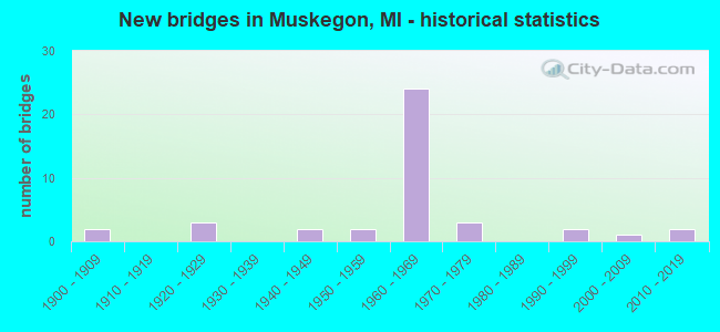
- New bridges - historical statistics
- 21900-1909
- 31920-1929
- 21940-1949
- 21950-1959
- 241960-1969
- 31970-1979
- 21990-1999
- 12000-2009
- 22010-2019
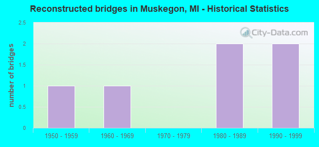
- Reconstructed bridges - Historical Statistics
- 11950-1959
- 11960-1969
- 01970-1979
- 21980-1989
- 21990-1999
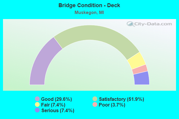
- Bridge Condition - Deck
- 29.6%Good
- 51.9%Satisfactory
- 7.4%Fair
- 3.7%Poor
- 7.4%Serious
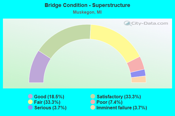
- Bridge Condition - Superstructure
- 18.5%Good
- 33.3%Satisfactory
- 33.3%Fair
- 7.4%Poor
- 3.7%Serious
- 3.7%Imminent failure
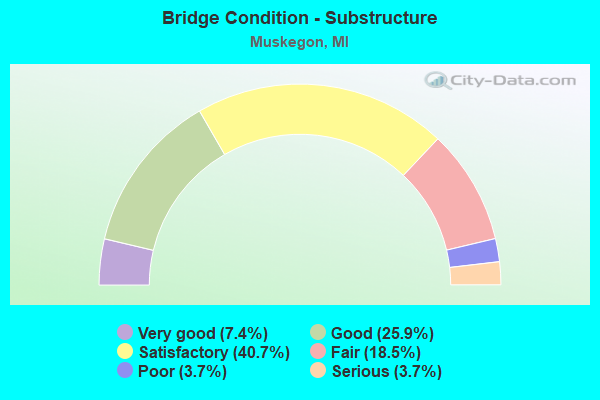
- Bridge Condition - Substructure
- 7.4%Very good
- 25.9%Good
- 40.7%Satisfactory
- 18.5%Fair
- 3.7%Poor
- 3.7%Serious
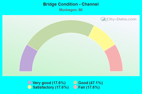
- Bridge Condition - Channel
- 17.6%Very good
- 47.1%Good
- 17.6%Satisfactory
- 17.6%Fair
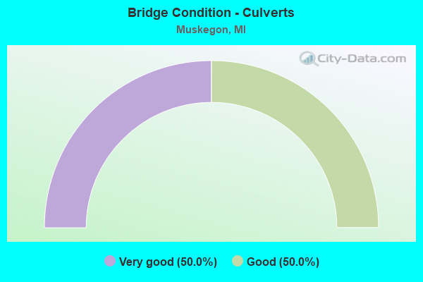
- Bridge Condition - Culverts
- 50.0%Very good
- 50.0%Good
Find on map >> Show street view
Structure Number: 762, Location: 5.0 MI SE OF BENZONIA (Lat: 44.557250, Lng: -86.053350), Route carried "on" structure: State highway 115, Year Built: 1940, Year Reconstructed: 2003, Status: Open, Structure Length: 4.57m (14.99ft), Average Daily Traffic: 2,595 (year 2007), Truck Traffic: 7%, Average Future Daily Traffic: 3,628 (year 2018), Design Load: H 20, Features Intersected: BETSIE RIVER
Minimum Vertical Clearance: 30.48m (100.00ft), Kilometerpoint: 4.976, Lanes on structure: 2, Base Highway Network: Yes (Inventory Route: 107, Subroute: 3), Owner: State Highway Agency, Approaching Roadway Width: 12.8m (42.0ft), Skew: 2 degrees, Material/Design: Steel, Design/Construction: Stringer/Multi-beam, Number Of Spans In Main Unit: 3, Length of Maximum Span: 15.2m (49.9ft), Curb or Sidewalk Widths: Left: 0.4m (1.3ft), Right: 0.4m (1.3ft), Curb-To-Curb Width: 10.7m (35.1ft), Out-to-Out Width: 12.3m (40.4ft)
Condition: Deck: Good, Superstructure: Satisfactory, Substructure: Satisfactory, Channel: Satisfactory, Operating Rating: 86.8 metric tons, Method Used To Determine Operating Rating: Load Factor (LF) rating reported by rating factor (RF) method using MS18 loading, Inventory Rating: 52.2 metric tons, Method Used To Determine Inventory Rating: Load Factor (LF) rating reported by rating factor (RF) method using MS18 loading, Structural Evaluation: Equal to present minimum criteria, Deck Geometry: Somewhat better than minimum adequacy, Waterway Adequacy: Equal to present desirable criteria, Approach Roadway Alignment: Equal to present minimum criteria, Designated Inspection Frequency: Every 24 months, Inspection Date: July 2020, Deck Structure Type: Concrete Cast-file-Place, Wearing Surface/Protective System: Wearing Surface: Epoxy Overlay, Membrane: Preformed Fabric
Find on map >> Show street view
Structure Number: 77, Location: 3 MI EAST OF HONOR (Lat: 44.656339, Lng: -85.958100), Route carried "on" structure: County highway , Year Built: 1973, Status: Posted for load, Structure Length: 0.97m (3.18ft), Average Daily Traffic: 380 (year 2008), Truck Traffic: 1%, Average Future Daily Traffic: 510 (year 2018), Design Load: HS 20, Features Intersected: PLATTE RIVER, Facility Carried by Structure: HAZE ROAD
Minimum Vertical Clearance: 30.48m (100.00ft), Kilometerpoint: 1.262, Lanes on structure: 2, Owner: County Highway Agency, Approaching Roadway Width: 7.3m (24.0ft), Material/Design: Steel, Design/Construction: Stringer/Multi-beam, Number Of Spans In Main Unit: 1, Length of Maximum Span: 9.7m (31.8ft), Curb-To-Curb Width: 7.3m (24.0ft), Out-to-Out Width: 7.3m (24.0ft)
Condition: Deck: Serious, Superstructure: Poor, Substructure: Poor, Channel: Good, Operating Rating: 30.5 metric tons, Method Used To Determine Operating Rating: Load Factor (LF) rating reported by rating factor (RF) method using MS18 loading, Inventory Rating: 18.1 metric tons, Method Used To Determine Inventory Rating: Load Factor (LF) rating reported by rating factor (RF) method using MS18 loading, Structural Evaluation: Meets minimum limits, Deck Geometry: Somewhat better than minimum adequacy, Waterway Adequacy: Better than present minimum criteria, Approach Roadway Alignment: Better than present minimum criteria, Bridge Posting: Required (Relationship of Operating Rating to Maximum Legal Load: 30.0 - 39.9% below), Designated Inspection Frequency: Every 12 months, Inspection Date: August 2021, Deck Structure Type: Corrugated Steel, Wearing Surface/Protective System: Wearing Surface: Bituminous
Find on map >> Show street view
Structure Number: 1261, Location: 0.5 MI E OF M-66 (Lat: 42.273511, Lng: -85.169331), Route carried "on" structure: Interstate 94, Year Built: 1959, Status: Open, Structure Length: 4.73m (15.52ft), Average Daily Traffic: 22,400 (year 2010), Truck Traffic: 23%, Average Future Daily Traffic: 24,300 (year 2030), Design Load: HS 20, Features Intersected: 6 1/2 MILE ROAD
Minimum Vertical Clearance: 30.48m (100.00ft), Kilometerpoint: 11.084, Lanes on structure: 2, Lanes under structure: 2, Base Highway Network: Yes (Inventory Route: 129, Subroute: 6), Owner: State Highway Agency, Approaching Roadway Width: 11.7m (38.4ft), Skew: 3 degrees, Material/Design: Concrete continuous, Design/Construction: Tee Beam, Number Of Spans In Main Unit: 3, Length of Maximum Span: 18.5m (60.7ft), Curb-To-Curb Width: 12.8m (42.0ft), Out-to-Out Width: 14.4m (47.2ft)
Condition: Deck: Poor, Superstructure: Fair, Substructure: Satisfactory, Operating Rating: 52.8 metric tons, Method Used To Determine Operating Rating: Load Factor (LF) rating reported by rating factor (RF) method using MS18 loading, Inventory Rating: 31.8 metric tons, Method Used To Determine Inventory Rating: Load Factor (LF) rating reported by rating factor (RF) method using MS18 loading, Structural Evaluation: Somewhat better than minimum adequacy, Deck Geometry: Equal to present desirable criteria, Underclear: Somewhat better than minimum adequacy, Approach Roadway Alignment: Equal to present desirable criteria, Designated Inspection Frequency: Every 24 months, Other Special Inspection Frequency: Every 24 months, Inspection Date: August 2021, Other Special Inspection Date: August 2020, Deck Structure Type: Concrete Cast-file-Place, Wearing Surface/Protective System: Wearing Surface: Latex Concrete
Find on map >> Show street view
Structure Number: 757, Location: 1.0 MI S OF M-46 (Lat: 43.219708, Lng: -86.204800), Route carried "on" structure: US 31, Year Built: 1960, Status: Open, Structure Length: 6.89m (22.60ft), Average Daily Traffic: 32,065 (year 2018), Truck Traffic: 5%, Average Future Daily Traffic: 36,874 (year 2038), Design Load: HS 20, Features Intersected: MI SHORE RR & LAKETON AV
Minimum Vertical Clearance: 30.48m (100.00ft), Kilometerpoint: 11.403, Lanes on structure: 3, Lanes under structure: 4, Base Highway Network: Yes (Inventory Route: 85, Subroute: 9), Owner: State Highway Agency, Approaching Roadway Width: 12.5m (41.0ft), Material/Design: Steel, Design/Construction: Stringer/Multi-beam, Number Of Spans In Main Unit: 4, Length of Maximum Span: 22.5m (73.8ft), Curb-To-Curb Width: 13.4m (44.0ft), Out-to-Out Width: 14.3m (46.9ft)
Condition: Deck: Satisfactory, Superstructure: Satisfactory, Substructure: Satisfactory, Operating Rating: 69.7 metric tons, Method Used To Determine Operating Rating: Load Factor (LF) rating reported by rating factor (RF) method using MS18 loading, Inventory Rating: 41.8 metric tons, Method Used To Determine Inventory Rating: Load Factor (LF) rating reported by rating factor (RF) method using MS18 loading, Structural Evaluation: Equal to present minimum criteria, Deck Geometry: Meets minimum limits, Underclear: High priority of corrective action, Approach Roadway Alignment: Better than present minimum criteria, Designated Inspection Frequency: Every 24 months, Inspection Date: July 2021, Deck Structure Type: Concrete Cast-file-Place, Wearing Surface/Protective System: Wearing Surface: Epoxy Overlay
Find on map >> Show street view
Structure Number: 7571, Location: 1.0 MI S OF M-46 (Lat: 43.219500, Lng: -86.205119), Route carried "on" structure: US 31, Year Built: 1960, Status: Open, Structure Length: 6.89m (22.60ft), Average Daily Traffic: 28,281 (year 2011), Truck Traffic: 5%, Average Future Daily Traffic: 31,560 (year 2031), Design Load: HS 20, Features Intersected: MI SHORE RR & LAKETON AV
Minimum Vertical Clearance: 30.48m (100.00ft), Kilometerpoint: 11.403, Lanes on structure: 3, Lanes under structure: 4, Base Highway Network: Yes (Inventory Route: 85, Subroute: 2), Owner: State Highway Agency, Approaching Roadway Width: 12.5m (41.0ft), Skew: 10 degrees, Material/Design: Steel, Design/Construction: Stringer/Multi-beam, Number Of Spans In Main Unit: 4, Length of Maximum Span: 22.5m (73.8ft), Curb-To-Curb Width: 13.4m (44.0ft), Out-to-Out Width: 14.4m (47.2ft)
Condition: Deck: Satisfactory, Superstructure: Fair, Substructure: Satisfactory, Operating Rating: 66.7 metric tons, Method Used To Determine Operating Rating: Load Factor (LF) rating reported by rating factor (RF) method using MS18 loading, Inventory Rating: 39.9 metric tons, Method Used To Determine Inventory Rating: Load Factor (LF) rating reported by rating factor (RF) method using MS18 loading, Structural Evaluation: Somewhat better than minimum adequacy, Deck Geometry: Meets minimum limits, Underclear: Meets minimum limits, Approach Roadway Alignment: Equal to present minimum criteria, Designated Inspection Frequency: Every 24 months, Inspection Date: July 2021, Deck Structure Type: Concrete Cast-file-Place, Wearing Surface/Protective System: Wearing Surface: Epoxy Overlay
Find on map >> Show street view
Structure Number: 7574, Location: 2.3 MI N OF I-96 (Lat: 43.205022, Lng: -86.204928), Route carried "on" structure: County highway 2007, Year Built: 1960, Status: Open, Structure Length: 6.25m (20.51ft), Average Daily Traffic: 25,187 (year 1997), Truck Traffic: 3%, Average Future Daily Traffic: 7,440 (year 1977), Design Load: H 20, Features Intersected: US-31, Facility Carried by Structure: SHERMAN RD
Minimum Vertical Clearance: 30.48m (100.00ft), Kilometerpoint: 9.431, Lanes on structure: 4, Lanes under structure: 5, Owner: State Highway Agency, Approaching Roadway Width: 16.7m (54.8ft), Material/Design: Concrete continuous, Design/Construction: Tee Beam, Number Of Spans In Main Unit: 4, Length of Maximum Span: 21.0m (68.9ft), Curb or Sidewalk Widths: Left: 0.8m (2.6ft), Right: 0.8m (2.6ft), Curb-To-Curb Width: 14.6m (47.9ft), Out-to-Out Width: 16.8m (55.1ft)
Condition: Deck: Satisfactory, Superstructure: Fair, Substructure: Satisfactory, Operating Rating: 53.5 metric tons, Method Used To Determine Operating Rating: Load Factor (LF) rating reported by rating factor (RF) method using MS18 loading, Inventory Rating: 32.1 metric tons, Method Used To Determine Inventory Rating: Load Factor (LF) rating reported by rating factor (RF) method using MS18 loading, Structural Evaluation: Somewhat better than minimum adequacy, Deck Geometry: High priority of replacement, Underclear: Somewhat better than minimum adequacy, Approach Roadway Alignment: Better than present minimum criteria, Designated Inspection Frequency: Every 24 months, Inspection Date: July 2021, Deck Structure Type: Concrete Cast-file-Place, Wearing Surface/Protective System: Wearing Surface: Latex Concrete
Find on map >> Show street view
Structure Number: 7575, Location: @ M-46 (Lat: 43.234231, Lng: -86.204514), Route carried "on" structure: State highway 46, Year Built: 1960, Status: Open, Structure Length: 7.43m (24.38ft), Average Daily Traffic: 16,835 (year 2007), Truck Traffic: 3%, Average Future Daily Traffic: 17,727 (year 2018), Design Load: HS 20, Features Intersected: US-31
Minimum Vertical Clearance: 30.48m (100.00ft), Kilometerpoint: 3.581, Lanes on structure: 6, Lanes under structure: 6, Base Highway Network: Yes (Inventory Route: 85, Subroute: 3), Owner: State Highway Agency, Approaching Roadway Width: 25.9m (85.0ft), Skew: 30 degrees, Material/Design: Concrete continuous, Design/Construction: Tee Beam, Number Of Spans In Main Unit: 4, Length of Maximum Span: 21.0m (68.9ft), Curb or Sidewalk Widths: Left: 1.5m (4.9ft), Right: 1.5m (4.9ft), Curb-To-Curb Width: 25.9m (85.0ft), Out-to-Out Width: 29.7m (97.4ft)
Condition: Deck: Fair, Superstructure: Fair, Substructure: Satisfactory, Operating Rating: 54.1 metric tons, Method Used To Determine Operating Rating: Load Factor (LF) rating reported by rating factor (RF) method using MS18 loading, Inventory Rating: 32.4 metric tons, Method Used To Determine Inventory Rating: Load Factor (LF) rating reported by rating factor (RF) method using MS18 loading, Structural Evaluation: Somewhat better than minimum adequacy, Deck Geometry: Equal to present minimum criteria, Underclear: High priority of corrective action, Approach Roadway Alignment: Equal to present minimum criteria, Length Of Structure Improvement: 7.44m (24.41ft), Designated Inspection Frequency: Every 24 months, Inspection Date: July 2021, Bridge Improvement Cost: $359,000, Roadway Improvement Cost: $47,000, Total Project Cost: $549,000, Deck Structure Type: Concrete Cast-file-Place, Wearing Surface/Protective System: Wearing Surface: Latex Concrete
Find on map >> Show street view
Structure Number: 7582, Location: 2.0 MI N OF M-46 (Lat: 43.262917, Lng: -86.205644), Route carried "on" structure: US 31, Year Built: 1964, Status: Open, Structure Length: 5.94m (19.49ft), Average Daily Traffic: 19,600 (year 2015), Truck Traffic: 5%, Average Future Daily Traffic: 22,540 (year 2035), Design Load: HS 20, Features Intersected: MUSKEGON RIVER
Minimum Vertical Clearance: 30.48m (100.00ft), Kilometerpoint: 16.245, Lanes on structure: 3, Base Highway Network: Yes (Inventory Route: 85, Subroute: 2), Owner: State Highway Agency, Approaching Roadway Width: 15.8m (51.8ft), Skew: 1 degrees, Material/Design: Steel, Design/Construction: Stringer/Multi-beam, Number Of Spans In Main Unit: 3, Length of Maximum Span: 19.8m (65.0ft), Curb-To-Curb Width: 15.7m (51.5ft), Out-to-Out Width: 16.7m (54.8ft)
Condition: Deck: Satisfactory, Superstructure: Satisfactory, Substructure: Good, Channel: Good, Operating Rating: 57.3 metric tons, Method Used To Determine Operating Rating: Load Factor (LF) rating reported by rating factor (RF) method using MS18 loading, Inventory Rating: 34.3 metric tons, Method Used To Determine Inventory Rating: Load Factor (LF) rating reported by rating factor (RF) method using MS18 loading, Structural Evaluation: Equal to present minimum criteria, Deck Geometry: Somewhat better than minimum adequacy, Waterway Adequacy: Equal to present desirable criteria, Approach Roadway Alignment: Equal to present minimum criteria, Designated Inspection Frequency: Every 24 months, Inspection Date: July 2020, Deck Structure Type: Concrete Cast-file-Place, Wearing Surface/Protective System: Wearing Surface: Latex Concrete
Find on map >> Show street view
Structure Number: 7583, Location: 2.0 MI N OF M-46 (Lat: 43.262981, Lng: -86.203492), Route carried "on" structure: US 31, Year Built: 1964, Status: Open, Structure Length: 5.94m (19.49ft), Average Daily Traffic: 22,817 (year 2007), Truck Traffic: 6%, Average Future Daily Traffic: 26,629 (year 2018), Design Load: HS 20, Features Intersected: MUSKEGON RIVER
Minimum Vertical Clearance: 30.48m (100.00ft), Kilometerpoint: 16.234, Lanes on structure: 4, Base Highway Network: Yes (Inventory Route: 85, Subroute: 9), Owner: State Highway Agency, Approaching Roadway Width: 21.3m (69.9ft), Skew: 1 degrees, Material/Design: Steel, Design/Construction: Stringer/Multi-beam, Number Of Spans In Main Unit: 3, Length of Maximum Span: 19.8m (65.0ft), Curb or Sidewalk Widths: Left: 0.1m (0.3ft), Right: 0.1m (0.3ft), Curb-To-Curb Width: 19.5m (64.0ft), Out-to-Out Width: 20.4m (66.9ft)
Condition: Deck: Satisfactory, Superstructure: Fair, Substructure: Very good, Channel: Good, Operating Rating: 88.1 metric tons, Method Used To Determine Operating Rating: Load Factor (LF) rating reported by rating factor (RF) method using MS18 loading, Inventory Rating: 52.8 metric tons, Method Used To Determine Inventory Rating: Load Factor (LF) rating reported by rating factor (RF) method using MS18 loading, Structural Evaluation: Somewhat better than minimum adequacy, Deck Geometry: Somewhat better than minimum adequacy, Waterway Adequacy: Equal to present desirable criteria, Approach Roadway Alignment: Better than present minimum criteria, Designated Inspection Frequency: Every 24 months, Inspection Date: July 2020, Deck Structure Type: Concrete Cast-file-Place, Wearing Surface/Protective System: Wearing Surface: Latex Concrete
Find on map >> Show street view
Structure Number: 7584, Location: 2.6 MI N OF M-46 (Lat: 43.272475, Lng: -86.203994), Route carried "on" structure: US 31, Year Built: 1964, Status: Open, Structure Length: 9.88m (32.41ft), Average Daily Traffic: 19,600 (year 2015), Truck Traffic: 5%, Average Future Daily Traffic: 22,540 (year 2035), Design Load: HS 20, Features Intersected: N CHAN MUSKEGON RIVER
Minimum Vertical Clearance: 30.48m (100.00ft), Kilometerpoint: 17.316, Lanes on structure: 3, Base Highway Network: Yes (Inventory Route: 85, Subroute: 2), Owner: State Highway Agency, Approaching Roadway Width: 15.2m (49.9ft), Material/Design: Steel, Design/Construction: Stringer/Multi-beam, Number Of Spans In Main Unit: 4, Length of Maximum Span: 27.4m (89.9ft), Curb-To-Curb Width: 13.1m (43.0ft), Out-to-Out Width: 14.8m (48.6ft)
Condition: Deck: Good, Superstructure: Fair, Substructure: Satisfactory, Channel: Good, Operating Rating: 83.3 metric tons, Method Used To Determine Operating Rating: Load Factor (LF) rating reported by rating factor (RF) method using MS18 loading, Inventory Rating: 49.9 metric tons, Method Used To Determine Inventory Rating: Load Factor (LF) rating reported by rating factor (RF) method using MS18 loading, Structural Evaluation: Somewhat better than minimum adequacy, Deck Geometry: Meets minimum limits, Waterway Adequacy: Equal to present minimum criteria, Approach Roadway Alignment: Better than present minimum criteria, Designated Inspection Frequency: Every 24 months, Underwater Inspection Frequency: Every 60 months, Inspection Date: August 2020, Underwater Inspection Date: June 2020, Deck Structure Type: Concrete Cast-file-Place, Wearing Surface/Protective System: Wearing Surface: Latex Concrete
Find on map >> Show street view
Structure Number: 7585, Location: 2.6 MI N OF M-46 (Lat: 43.272439, Lng: -86.202733), Route carried "on" structure: US 31, Year Built: 1964, Status: Open, Structure Length: 9.88m (32.41ft), Average Daily Traffic: 19,600 (year 2015), Truck Traffic: 5%, Average Future Daily Traffic: 22,540 (year 2035), Design Load: HS 20, Features Intersected: N CHAN MUSKEGON RIVER
Minimum Vertical Clearance: 30.48m (100.00ft), Kilometerpoint: 17.285, Lanes on structure: 3, Base Highway Network: Yes (Inventory Route: 85, Subroute: 9), Owner: State Highway Agency, Approaching Roadway Width: 14.3m (46.9ft), Material/Design: Steel, Design/Construction: Stringer/Multi-beam, Number Of Spans In Main Unit: 4, Length of Maximum Span: 27.4m (89.9ft), Curb-To-Curb Width: 13.1m (43.0ft), Out-to-Out Width: 14.8m (48.6ft)
Condition: Deck: Satisfactory, Superstructure: Fair, Substructure: Satisfactory, Channel: Good, Operating Rating: 83.3 metric tons, Method Used To Determine Operating Rating: Load Factor (LF) rating reported by rating factor (RF) method using MS18 loading, Inventory Rating: 49.9 metric tons, Method Used To Determine Inventory Rating: Load Factor (LF) rating reported by rating factor (RF) method using MS18 loading, Structural Evaluation: Somewhat better than minimum adequacy, Deck Geometry: Meets minimum limits, Waterway Adequacy: Equal to present minimum criteria, Approach Roadway Alignment: Better than present minimum criteria, Designated Inspection Frequency: Every 24 months, Underwater Inspection Frequency: Every 60 months, Inspection Date: August 2020, Underwater Inspection Date: June 2020, Deck Structure Type: Concrete Cast-file-Place, Wearing Surface/Protective System: Wearing Surface: Latex Concrete
Find on map >> Show street view
Structure Number: 7593, Location: IN MUSKEGON (Lat: 43.245136, Lng: -86.204325), Route carried "on" structure: City street 2007, Year Built: 1964, Status: Open, Structure Length: 3.68m (12.07ft), Average Daily Traffic: 10,712 (year 1997), Truck Traffic: 3%, Average Future Daily Traffic: 4,370 (year 1977), Design Load: H 20, Features Intersected: US-31, Facility Carried by Structure: MARQUETTE RD
Minimum Vertical Clearance: 30.48m (100.00ft), Kilometerpoint: 2.853, Lanes on structure: 4, Lanes under structure: 4, Owner: State Highway Agency, Approaching Roadway Width: 13.4m (44.0ft), Material/Design: Steel, Design/Construction: Stringer/Multi-beam, Number Of Spans In Main Unit: 2, Length of Maximum Span: 18.6m (61.0ft), Curb or Sidewalk Widths: Left: 1.8m (5.9ft), Right: 1.8m (5.9ft), Curb-To-Curb Width: 13.4m (44.0ft), Out-to-Out Width: 17.8m (58.4ft)
Condition: Deck: Satisfactory, Superstructure: Fair, Substructure: Good, Operating Rating: 55.7 metric tons, Method Used To Determine Operating Rating: Load Factor (LF) rating reported by rating factor (RF) method using MS18 loading, Inventory Rating: 33.4 metric tons, Method Used To Determine Inventory Rating: Load Factor (LF) rating reported by rating factor (RF) method using MS18 loading, Structural Evaluation: Somewhat better than minimum adequacy, Deck Geometry: High priority of replacement, Underclear: High priority of corrective action, Approach Roadway Alignment: Equal to present desirable criteria, Length Of Structure Improvement: 3.69m (12.11ft), Designated Inspection Frequency: Every 24 months, Inspection Date: July 2021, Bridge Improvement Cost: $182,000, Roadway Improvement Cost: $11,000, Total Project Cost: $133,000, Deck Structure Type: Concrete Cast-file-Place, Wearing Surface/Protective System: Wearing Surface: Latex Concrete
Find on map >> Show street view
Structure Number: 7594, Location: 0.2 MI N OF MUSKEGON (Lat: 43.257375, Lng: -86.206533), Route carried "on" structure: Business US 31, Year Built: 1964, Status: Open, Structure Length: 5.30m (17.39ft), Average Daily Traffic: 20,000 (year 1995), Truck Traffic: 7%, Average Future Daily Traffic: 13,844 (year 2015), Design Load: HS 20, Features Intersected: US-31 SB
Minimum Vertical Clearance: 30.48m (100.00ft), Kilometerpoint: 0.455, Lanes on structure: 2, Lanes under structure: 2, Base Highway Network: Yes (Inventory Route: 85, Subroute: 7), Owner: State Highway Agency, Approaching Roadway Width: 12.2m (40.0ft), Skew: 2 degrees, Material/Design: Steel, Design/Construction: Stringer/Multi-beam, Number Of Spans In Main Unit: 3, Length of Maximum Span: 26.8m (87.9ft), Curb or Sidewalk Widths: Left: 0.1m (0.3ft), Right: 0.1m (0.3ft), Curb-To-Curb Width: 12.0m (39.4ft), Out-to-Out Width: 13.0m (42.7ft)
Condition: Deck: Satisfactory, Superstructure: Good, Substructure: Good, Operating Rating: 67.4 metric tons, Method Used To Determine Operating Rating: Load Factor (LF) rating reported by rating factor (RF) method using MS18 loading, Inventory Rating: 40.5 metric tons, Method Used To Determine Inventory Rating: Load Factor (LF) rating reported by rating factor (RF) method using MS18 loading, Structural Evaluation: Better than present minimum criteria, Deck Geometry: Better than present minimum criteria, Underclear: High priority of corrective action, Approach Roadway Alignment: Better than present minimum criteria, Designated Inspection Frequency: Every 24 months, Inspection Date: July 2020, Deck Structure Type: Concrete Cast-file-Place, Wearing Surface/Protective System: Wearing Surface: Latex Concrete
Find on map >> Show street view
Structure Number: 7595, Location: 0.2 MI N OF MUSKEGON (Lat: 43.257375, Lng: -86.206536), Route carried "on" structure: Ramp US 31, Year Built: 1964, Status: Open, Structure Length: 8.26m (27.10ft), Average Daily Traffic: 4,200 (year 1988), Truck Traffic: 8%, Average Future Daily Traffic: 2,100 (year 1977), Design Load: HS 20, Features Intersected: US-31 SB&US-31 BR EB(TOP, Facility Carried by Structure: NB RAMP TO WB BR
Minimum Vertical Clearance: 30.48m (100.00ft), Kilometerpoint: 15.624, Lanes on structure: 2, Lanes under structure: 2, Owner: State Highway Agency, Approaching Roadway Width: 9.1m (29.9ft), Skew: 3 degrees, Material/Design: Steel, Design/Construction: Stringer/Multi-beam, Number Of Spans In Main Unit: 3, Length of Maximum Span: 28.3m (92.8ft), Curb or Sidewalk Widths: Left: 0.7m (2.3ft), Right: 0.7m (2.3ft), Curb-To-Curb Width: 7.1m (23.3ft), Out-to-Out Width: 8.6m (28.2ft)
Condition: Deck: Satisfactory, Superstructure: Satisfactory, Substructure: Fair, Operating Rating: 72.3 metric tons, Method Used To Determine Operating Rating: Load Factor (LF) rating reported by rating factor (RF) method using MS18 loading, Inventory Rating: 43.4 metric tons, Method Used To Determine Inventory Rating: Load Factor (LF) rating reported by rating factor (RF) method using MS18 loading, Structural Evaluation: Somewhat better than minimum adequacy, Deck Geometry: High priority of replacement, Underclear: High priority of corrective action, Approach Roadway Alignment: Better than present minimum criteria, Designated Inspection Frequency: Every 24 months, Inspection Date: July 2021, Deck Structure Type: Concrete Cast-file-Place, Wearing Surface/Protective System: Wearing Surface: Monolithic Concrete
Find on map >> Show street view
Structure Number: 7596, Location: 2.0 MI NE OF MUSKEGON (Lat: 43.292503, Lng: -86.208617), Route carried "on" structure: US 31, Year Built: 1964, Year Reconstructed: 2002, Status: Open, Structure Length: 5.97m (19.59ft), Average Daily Traffic: 22,817 (year 2007), Truck Traffic: 5%, Average Future Daily Traffic: 19,858 (year 2018), Design Load: HS 25 or greater, Features Intersected: M-120
Minimum Vertical Clearance: 30.48m (100.00ft), Kilometerpoint: 19.612, Lanes on structure: 2, Lanes under structure: 6, Base Highway Network: Yes (Inventory Route: 85, Subroute: 2), Owner: State Highway Agency, Approaching Roadway Width: 12.2m (40.0ft), Skew: 1 degrees, Material/Design: Steel, Design/Construction: Stringer/Multi-beam, Number Of Spans In Main Unit: 3, Length of Maximum Span: 29.6m (97.1ft), Curb-To-Curb Width: 16.5m (54.1ft), Out-to-Out Width: 17.6m (57.7ft)
Condition: Deck: Satisfactory, Superstructure: Good, Substructure: Satisfactory, Operating Rating: 72.6 metric tons, Method Used To Determine Operating Rating: Load Factor (LF), Inventory Rating: 43.5 metric tons, Method Used To Determine Inventory Rating: Load Factor (LF), Structural Evaluation: Equal to present minimum criteria, Deck Geometry: Superior to present desirable criteria, Underclear: Equal to present minimum criteria, Approach Roadway Alignment: Better than present minimum criteria, Designated Inspection Frequency: Every 24 months, Inspection Date: July 2020, Deck Structure Type: Concrete Cast-file-Place, Wearing Surface/Protective System: Wearing Surface: Monolithic Concrete
Find on map >> Show street view
Structure Number: 7597, Location: 2.0 MI NE OF MUSKEGON (Lat: 43.292789, Lng: -86.207933), Route carried "on" structure: US 31, Year Built: 1964, Status: Open, Structure Length: 5.97m (19.59ft), Average Daily Traffic: 22,817 (year 2007), Truck Traffic: 5%, Average Future Daily Traffic: 19,858 (year 2018), Design Load: HS 20, Features Intersected: M-120
Minimum Vertical Clearance: 30.48m (100.00ft), Kilometerpoint: 19.619, Lanes on structure: 2, Lanes under structure: 6, Base Highway Network: Yes (Inventory Route: 85, Subroute: 9), Owner: State Highway Agency, Approaching Roadway Width: 12.2m (40.0ft), Skew: 1 degrees, Material/Design: Steel, Design/Construction: Stringer/Multi-beam, Number Of Spans In Main Unit: 3, Length of Maximum Span: 29.5m (96.8ft), Curb or Sidewalk Widths: Left: 0.1m (0.3ft), Right: 0.1m (0.3ft), Curb-To-Curb Width: 12.3m (40.4ft), Out-to-Out Width: 13.0m (42.7ft)
Condition: Deck: Satisfactory, Superstructure: Satisfactory, Substructure: Good, Operating Rating: 59.9 metric tons, Method Used To Determine Operating Rating: Load Factor (LF) rating reported by rating factor (RF) method using MS18 loading, Inventory Rating: 36.0 metric tons, Method Used To Determine Inventory Rating: Load Factor (LF) rating reported by rating factor (RF) method using MS18 loading, Structural Evaluation: Equal to present minimum criteria, Deck Geometry: Better than present minimum criteria, Underclear: Somewhat better than minimum adequacy, Approach Roadway Alignment: Equal to present desirable criteria, Designated Inspection Frequency: Every 24 months, Inspection Date: September 2020, Bridge Improvement Cost: $125,000, Deck Structure Type: Concrete Cast-file-Place, Wearing Surface/Protective System: Wearing Surface: Latex Concrete
Find on map >> Show street view
Structure Number: 7611, Location: IN MUSKEGON (Lat: 43.254258, Lng: -86.235692), Route carried "on" structure: State highway 120, Year Built: 2001, Status: Open, Structure Length: 8.46m (27.76ft), Average Daily Traffic: 27,282 (year 2007), Truck Traffic: 3%, Average Future Daily Traffic: 29,883 (year 2018), Design Load: HS 25 or greater, Features Intersected: MUSKEGON RIVER
Minimum Vertical Clearance: 30.48m (100.00ft), Kilometerpoint: 0.093, Lanes on structure: 4, Base Highway Network: Yes (Inventory Route: 85, Subroute: 6), Owner: State Highway Agency, Approaching Roadway Width: 19.2m (63.0ft), Skew: 6 degrees, Material/Design: Prestressed concrete, Design/Construction: Stringer/Multi-beam, Number Of Spans In Main Unit: 3, Length of Maximum Span: 32.6m (107.0ft), Curb-To-Curb Width: 20.4m (66.9ft), Out-to-Out Width: 21.3m (69.9ft)
Condition: Deck: Satisfactory, Superstructure: Satisfactory, Substructure: Fair, Channel: Very good, Inventory Rating: 47.9 metric tons, Method Used To Determine Inventory Rating: Load Factor (LF), Structural Evaluation: Somewhat better than minimum adequacy, Deck Geometry: Superior to present desirable criteria, Waterway Adequacy: Equal to present desirable criteria, Approach Roadway Alignment: Better than present minimum criteria, Designated Inspection Frequency: Every 24 months, Inspection Date: July 2021, Deck Structure Type: Concrete Cast-file-Place, Wearing Surface/Protective System: Wearing Surface: Monolithic Concrete, Deck Protection: Epoxy Coated Reinforcing
Find on map >> Show street view
Structure Number: 7634, Location: IN MUSKEGON (Lat: 43.251569, Lng: -86.233017), Route carried "on" structure: Business US 31, Year Built: 1964, Status: Open, Structure Length: 3.17m (10.40ft), Average Daily Traffic: 9,943 (year 2007), Truck Traffic: 5%, Average Future Daily Traffic: 11,061 (year 2018), Design Load: HS 20, Features Intersected: S BR MUSKEGON RIVER
Minimum Vertical Clearance: 30.48m (100.00ft), Kilometerpoint: 3.010, Lanes on structure: 4, Base Highway Network: Yes (Inventory Route: 85, Subroute: 4), Owner: State Highway Agency, Approaching Roadway Width: 19.5m (64.0ft), Skew: 2 degrees, Material/Design: Prestressed concrete, Design/Construction: Stringer/Multi-beam, Number Of Spans In Main Unit: 3, Length of Maximum Span: 11.2m (36.7ft), Curb-To-Curb Width: 19.4m (63.6ft), Out-to-Out Width: 20.4m (66.9ft)
Condition: Deck: Good, Superstructure: Satisfactory, Substructure: Very good, Channel: Good, Operating Rating: 86.0 metric tons, Method Used To Determine Operating Rating: Load Factor (LF), Inventory Rating: 51.5 metric tons, Method Used To Determine Inventory Rating: Load Factor (LF), Structural Evaluation: Equal to present minimum criteria, Deck Geometry: Somewhat better than minimum adequacy, Waterway Adequacy: Equal to present desirable criteria, Approach Roadway Alignment: Better than present minimum criteria, Designated Inspection Frequency: Every 24 months, Inspection Date: April 2020, Deck Structure Type: Concrete Cast-file-Place, Wearing Surface/Protective System: Wearing Surface: Latex Concrete
Find on map >> Show street view
Structure Number: 7635, Location: IN MUSKEGON (Lat: 43.253775, Lng: -86.228694), Route carried "on" structure: Business US 31, Year Built: 1964, Status: Open, Structure Length: 3.20m (10.50ft), Average Daily Traffic: 11,592 (year 2007), Truck Traffic: 5%, Average Future Daily Traffic: 10,686 (year 2018), Design Load: HS 20, Features Intersected: S BR MUSKEGON RIVER
Minimum Vertical Clearance: 30.48m (100.00ft), Kilometerpoint: 3.444, Lanes on structure: 2, Base Highway Network: Yes (Inventory Route: 85, Subroute: 3), Owner: State Highway Agency, Approaching Roadway Width: 12.2m (40.0ft), Skew: 1 degrees, Material/Design: Prestressed concrete, Design/Construction: Stringer/Multi-beam, Number Of Spans In Main Unit: 3, Length of Maximum Span: 11.2m (36.7ft), Curb or Sidewalk Widths: Left: 0.1m (0.3ft), Right: 0.1m (0.3ft), Curb-To-Curb Width: 12.0m (39.4ft), Out-to-Out Width: 13.1m (43.0ft)
Condition: Deck: Good, Superstructure: Good, Substructure: Fair, Channel: Satisfactory, Operating Rating: 54.6 metric tons, Method Used To Determine Operating Rating: Load Factor (LF), Inventory Rating: 32.7 metric tons, Method Used To Determine Inventory Rating: Load Factor (LF), Structural Evaluation: Somewhat better than minimum adequacy, Deck Geometry: Equal to present minimum criteria, Waterway Adequacy: Better than present minimum criteria, Approach Roadway Alignment: Better than present minimum criteria, Designated Inspection Frequency: Every 24 months, Inspection Date: April 2020, Deck Structure Type: Concrete Cast-file-Place, Wearing Surface/Protective System: Wearing Surface: Latex Concrete
Find on map >> Show street view
Structure Number: 7636, Location: IN MUSKEGON (Lat: 43.253308, Lng: -86.228403), Route carried "on" structure: Business US 31, Year Built: 2010, Status: Open, Structure Length: 3.51m (11.52ft), Average Daily Traffic: 11,592 (year 2007), Truck Traffic: 5%, Average Future Daily Traffic: 10,686 (year 2018), Design Load: Greater than HL93, Features Intersected: MUSKEGON RIVER
Minimum Vertical Clearance: 30.48m (100.00ft), Kilometerpoint: 3.457, Lanes on structure: 2, Base Highway Network: Yes (Inventory Route: 85, Subroute: 4), Owner: State Highway Agency, Approaching Roadway Width: 13.5m (44.3ft), Skew: 1 degrees, Material/Design: Prestressed concrete, Design/Construction: Box Beam or Girders - Single/Spread, Number Of Spans In Main Unit: 3, Length of Maximum Span: 13.2m (43.3ft), Curb-To-Curb Width: 14.9m (48.9ft), Out-to-Out Width: 15.9m (52.2ft)
Condition: Deck: Good, Superstructure: Good, Substructure: Satisfactory, Channel: Very good, Operating Rating: 78.6 metric tons, Method Used To Determine Operating Rating: Load Factor (LF), Inventory Rating: 47.0 metric tons, Method Used To Determine Inventory Rating: Load Factor (LF), Structural Evaluation: Equal to present minimum criteria, Deck Geometry: Superior to present desirable criteria, Waterway Adequacy: Equal to present desirable criteria, Approach Roadway Alignment: Better than present minimum criteria, Designated Inspection Frequency: Every 24 months, Inspection Date: April 2020, Deck Structure Type: Concrete Cast-file-Place, Wearing Surface/Protective System: Wearing Surface: Monolithic Concrete, Deck Protection: Epoxy Coated Reinforcing
Find on map >> Show street view
Structure Number: 764, Location: 1.3 MI E OF US-31 (Lat: 43.197431, Lng: -86.186108), Route carried "on" structure: County highway 2007, Year Built: 1924, Year Reconstructed: 1963, Status: Open, Structure Length: 1.37m (4.49ft), Average Daily Traffic: 13,386 (year 2002), Truck Traffic: 7%, Average Future Daily Traffic: 19,892 (year 2022), Design Load: HS 20, Features Intersected: BLACK CREEK, Facility Carried by Structure: BLACK CREEK ROAD
Minimum Vertical Clearance: 30.48m (100.00ft), Kilometerpoint: 0.977, Lanes on structure: 2, Owner: County Highway Agency, Approaching Roadway Width: 12.2m (40.0ft), Material/Design: Prestressed concrete, Design/Construction: Box Beam or Girders - Multiple, Number Of Spans In Main Unit: 1, Length of Maximum Span: 13.1m (43.0ft), Curb-To-Curb Width: 9.4m (30.8ft), Out-to-Out Width: 10.1m (33.1ft)
Condition: Deck: Satisfactory, Superstructure: Fair, Substructure: Fair, Channel: Satisfactory, Operating Rating: 99.0 metric tons, Method Used To Determine Operating Rating: Load Factor (LF), Inventory Rating: 60.9 metric tons, Method Used To Determine Inventory Rating: Load Factor (LF), Structural Evaluation: Somewhat better than minimum adequacy, Deck Geometry: High priority of corrective action, Waterway Adequacy: Equal to present desirable criteria, Approach Roadway Alignment: Equal to present minimum criteria, Designated Inspection Frequency: Every 24 months, Inspection Date: September 2020, Deck Structure Type: Concrete Precast Panels, Wearing Surface/Protective System: Wearing Surface: Bituminous
Find on map >> Show street view
Structure Number: 7676, Location: 0.5 MI W OF MILLIRON RD (Lat: 43.201236, Lng: -86.165650), Route carried "on" structure: County highway 2007, Year Built: 1970, Status: Open, Structure Length: 1.28m (4.20ft), Average Daily Traffic: 4,143 (year 2004), Truck Traffic: 7%, Average Future Daily Traffic: 6,520 (year 2024), Design Load: H 20, Features Intersected: BLACK CREEK, Facility Carried by Structure: EAST BROADWAY
Minimum Vertical Clearance: 30.48m (100.00ft), Kilometerpoint: 9.166, Lanes on structure: 2, Owner: County Highway Agency, Approaching Roadway Width: 9.8m (32.2ft), Skew: 3 degrees, Material/Design: Prestressed concrete, Design/Construction: Box Beam or Girders - Multiple, Number Of Spans In Main Unit: 1, Length of Maximum Span: 12.8m (42.0ft), Curb-To-Curb Width: 9.1m (29.9ft), Out-to-Out Width: 9.3m (30.5ft)
Condition: Deck: Good, Superstructure: Satisfactory, Substructure: Good, Channel: Good, Operating Rating: 58.5 metric tons, Method Used To Determine Operating Rating: Load Factor (LF), Inventory Rating: 35.1 metric tons, Method Used To Determine Inventory Rating: Load Factor (LF), Structural Evaluation: Equal to present minimum criteria, Deck Geometry: Meets minimum limits, Waterway Adequacy: Better than present minimum criteria, Approach Roadway Alignment: Equal to present desirable criteria, Designated Inspection Frequency: Every 24 months, Inspection Date: September 2020, Deck Structure Type: Concrete Precast Panels, Wearing Surface/Protective System: Wearing Surface: Bituminous
Find on map >> Show street view
Structure Number: 7682, Location: 0.5 MI S OF RIVER RD (Lat: 43.288986, Lng: -86.223161), Route carried "on" structure: County highway 2007, Year Built: 1978, Status: Open, Structure Length: 0.67m (2.20ft), Average Daily Traffic: 1,799 (year 2004), Truck Traffic: 5%, Average Future Daily Traffic: 2,850 (year 2024), Design Load: HS 20+Mod, Features Intersected: BEAR CREEK, Facility Carried by Structure: NORTH GETTY
Minimum Vertical Clearance: 30.48m (100.00ft), Kilometerpoint: 1.782, Lanes on structure: 2, Owner: County Highway Agency, Approaching Roadway Width: 9.8m (32.2ft), Material/Design: Prestressed concrete, Design/Construction: Box Beam or Girders - Multiple, Number Of Spans In Main Unit: 1, Length of Maximum Span: 6.7m (22.0ft), Curb-To-Curb Width: 10.1m (33.1ft), Out-to-Out Width: 10.2m (33.5ft)
Condition: Deck: Good, Superstructure: Satisfactory, Substructure: Good, Channel: Fair, Operating Rating: 60.7 metric tons, Method Used To Determine Operating Rating: Load Factor (LF), Inventory Rating: 36.4 metric tons, Method Used To Determine Inventory Rating: Load Factor (LF), Structural Evaluation: Equal to present minimum criteria, Deck Geometry: Somewhat better than minimum adequacy, Waterway Adequacy: Equal to present desirable criteria, Approach Roadway Alignment: Equal to present desirable criteria, Designated Inspection Frequency: Every 24 months, Inspection Date: September 2020, Deck Structure Type: Concrete Precast Panels, Wearing Surface/Protective System: Wearing Surface: Bituminous
Find on map >> Show street view
Structure Number: 7698, Location: 0.1 MI N OF ADDISON AVE (Lat: 43.218217, Lng: -86.284536), Route carried "on" structure: City street 2007, Year Built: 1900, Year Reconstructed: 1986, Status: Open, Structure Length: 0.91m (2.99ft), Average Daily Traffic: 12,520 (year 2002), Average Future Daily Traffic: 15,100 (year 2022), Design Load: HS 20, Features Intersected: RUDDIMAN CREEK, Facility Carried by Structure: LAKESHORE DRIVE
Minimum Vertical Clearance: 30.48m (100.00ft), Kilometerpoint: 4.154, Lanes on structure: 3, Owner: City or Municipal Highway Agency, Approaching Roadway Width: 13.4m (44.0ft), Material/Design: Concrete, Design/Construction: Culvert, Number Of Spans In Main Unit: 1, Length of Maximum Span: 8.2m (26.9ft), Curb or Sidewalk Widths: Left: 1.8m (5.9ft), Right: 1.8m (5.9ft), Curb-To-Curb Width: 14.6m (47.9ft), Out-to-Out Width: 20.1m (65.9ft)
Condition: Channel: Good, Culverts: Good, Operating Rating: 54.4 metric tons, Method Used To Determine Operating Rating: Field evaluation and documented engineering judgment, Inventory Rating: 32.7 metric tons, Method Used To Determine Inventory Rating: Field evaluation and documented engineering judgment, Structural Evaluation: Better than present minimum criteria, Deck Geometry: Somewhat better than minimum adequacy, Waterway Adequacy: Equal to present desirable criteria, Approach Roadway Alignment: Equal to present desirable criteria, Designated Inspection Frequency: Every 24 months, Inspection Date: August 2020, Deck Structure Type: Concrete Cast-file-Place, Wearing Surface/Protective System: Wearing Surface: Bituminous, Membrane: Preformed Fabric, Deck Protection: Epoxy Coated Reinforcing
Find on map >> Show street view
Structure Number: 7699, Location: 0.02 E OF MYRTLE AVE (Lat: 43.236083, Lng: -86.239358), Route carried "on" structure: City street , Year Built: 1900, Year Reconstructed: 1969, Status: Open, Structure Length: 3.07m (10.07ft), Average Daily Traffic: 1,972 (year 2004), Average Future Daily Traffic: 2,009 (year 2024), Design Load: HS 20, Features Intersected: C O RAILROAD, Facility Carried by Structure: AMITY ST
Minimum Vertical Clearance: 30.48m (100.00ft), Kilometerpoint: 0.060, Lanes on structure: 2, Owner: City or Municipal Highway Agency, Approaching Roadway Width: 9.1m (29.9ft), Material/Design: Steel continuous, Design/Construction: Stringer/Multi-beam, Number Of Spans In Main Unit: 5, Length of Maximum Span: 8.8m (28.9ft), Curb or Sidewalk Widths: Left: 0.9m (3.0ft), Right: 0.9m (3.0ft), Curb-To-Curb Width: 7.3m (24.0ft), Out-to-Out Width: 9.7m (31.8ft)
Condition: Deck: Fair, Superstructure: Poor, Substructure: Satisfactory, Operating Rating: 47.9 metric tons, Method Used To Determine Operating Rating: Load Factor (LF), Inventory Rating: 28.7 metric tons, Method Used To Determine Inventory Rating: Load Factor (LF), Structural Evaluation: Meets minimum limits, Deck Geometry: Meets minimum limits, Underclear: Meets minimum limits, Approach Roadway Alignment: Meets minimum limits, Designated Inspection Frequency: Every 12 months, Inspection Date: August 2021, Deck Structure Type: Concrete Cast-file-Place, Wearing Surface/Protective System: Wearing Surface: Monolithic Concrete
Find on map >> Show street view
Structure Number: 77, Location: 0.25 MI N OF BAYOU ST (Lat: 43.251836, Lng: -86.235003), Route carried "on" structure: City street , Year Built: 1929, Status: Closed, Structure Length: 1.14m (3.74ft), Average Daily Traffic: 599 (year 2002), Average Future Daily Traffic: 1,000 (year 2022), Design Load: HS 15, Features Intersected: MUSKEGON RIVER S BRANCH, Facility Carried by Structure: OTTAWA ST
Minimum Vertical Clearance: 30.48m (100.00ft), Kilometerpoint: 1.555, Lanes on structure: 2, Owner: City or Municipal Highway Agency, Approaching Roadway Width: 12.2m (40.0ft), Material/Design: Steel, Design/Construction: Stringer/Multi-beam, Number Of Spans In Main Unit: 1, Length of Maximum Span: 10.9m (35.8ft), Curb or Sidewalk Widths: Left: 1.8m (5.9ft), Right: 1.8m (5.9ft), Curb-To-Curb Width: 12.2m (40.0ft), Out-to-Out Width: 16.4m (53.8ft)
Condition: Deck: Serious, Superstructure: Imminent failure, Substructure: Fair, Channel: Fair, Operating Rating: 4.5 metric tons, Method Used To Determine Operating Rating: Load Factor (LF), Inventory Rating: 2.7 metric tons, Method Used To Determine Inventory Rating: Load Factor (LF), Deck Geometry: Equal to present desirable criteria, Waterway Adequacy: High priority of corrective action, Approach Roadway Alignment: Equal to present desirable criteria, Bridge Posting: Required (Relationship of Operating Rating to Maximum Legal Load: > 39.9% below), Designated Inspection Frequency: Every 12 months, Inspection Date: August 2021, Deck Structure Type: Concrete Cast-file-Place, Wearing Surface/Protective System: Wearing Surface: Bituminous
Find on map >> Show street view
Structure Number: 9406, Location: 0.1 MI E OF CRESSWELL RD (Lat: 43.336228, Lng: -83.993278), Route carried "on" structure: ServiceCounty highway , Year Built: 1924, Year Reconstructed: 1991, Status: Posted for load, Structure Length: 1.86m (6.10ft), Average Daily Traffic: 39 (year 2007), Truck Traffic: 5%, Average Future Daily Traffic: 41 (year 2017), Design Load: H 15, Features Intersected: COLE DRAIN, Facility Carried by Structure: MOORE ROAD
Minimum Vertical Clearance: 30.48m (100.00ft), Kilometerpoint: 0.011, Lanes on structure: 2, Owner: County Highway Agency, Approaching Roadway Width: 7.0m (23.0ft), Material/Design: Steel, Design/Construction: Stringer/Multi-beam, Number Of Spans In Main Unit: 1, Length of Maximum Span: 17.6m (57.7ft), Curb-To-Curb Width: 6.0m (19.7ft), Out-to-Out Width: 6.9m (22.6ft)
Condition: Deck: Satisfactory, Superstructure: Serious, Substructure: Serious, Channel: Fair, Operating Rating: 39.9 metric tons, Method Used To Determine Operating Rating: Load Factor (LF) rating reported by rating factor (RF) method using MS18 loading, Inventory Rating: 24.0 metric tons, Method Used To Determine Inventory Rating: Load Factor (LF) rating reported by rating factor (RF) method using MS18 loading, Structural Evaluation: High priority of corrective action, Waterway Adequacy: Better than present minimum criteria, Approach Roadway Alignment: Somewhat better than minimum adequacy, Bridge Posting: Required (Relationship of Operating Rating to Maximum Legal Load: 20.0 - 29.9% below), Designated Inspection Frequency: Every 12 months, Inspection Date: May 2021, Deck Structure Type: Wood or Timber, Wearing Surface/Protective System: Wearing Surface: Gravel
Find on map >> Show street view
Structure Number: 1261, Location: 0.20 MI N OF SOUTHERN AVE (Lat: 43.228408, Lng: -86.259900), Route carried "on" structure: Business US 31, Year Built: 1993, Status: Open, Structure Length: 5.18m (16.99ft), Average Daily Traffic: 8,347 (year 2007), Average Future Daily Traffic: 10,000 (year 2022), Design Load: HS 20, Features Intersected: SB WEBSTER ST
Minimum Vertical Clearance: 30.48m (100.00ft), Kilometerpoint: 0.248, Lanes on structure: 2, Lanes under structure: 2, Owner: State Highway Agency, Approaching Roadway Width: 11.2m (36.7ft), Skew: 4 degrees, Material/Design: Prestressed concrete, Design/Construction: Stringer/Multi-beam, Number Of Spans In Main Unit: 3, Length of Maximum Span: 28.3m (92.8ft), Curb or Sidewalk Widths: Left: 2.9m (9.5ft), Right: 0.0m, Curb-To-Curb Width: 9.1m (29.9ft), Out-to-Out Width: 13.1m (43.0ft)
Condition: Deck: Good, Superstructure: Good, Substructure: Good, Operating Rating: 79.7 metric tons, Method Used To Determine Operating Rating: Load Factor (LF), Inventory Rating: 46.2 metric tons, Method Used To Determine Inventory Rating: Load Factor (LF), Structural Evaluation: Better than present minimum criteria, Deck Geometry: Meets minimum limits, Underclear: Better than present minimum criteria, Approach Roadway Alignment: Equal to present minimum criteria, Designated Inspection Frequency: Every 24 months, Inspection Date: April 2020, Deck Structure Type: Concrete Cast-file-Place, Wearing Surface/Protective System: Wearing Surface: Monolithic Concrete, Deck Protection: Epoxy Coated Reinforcing
Find on map >> Show street view
Structure Number: 13833, Location: MUSKEGON TWP SEC 5 (Lat: 43.282444, Lng: -86.232944), Route carried "on" structure: County highway , Year Built: 2014, Status: Open, Structure Length: 0.68m (2.23ft), Average Daily Traffic: 100 (year 2014), Truck Traffic: 2%, Average Future Daily Traffic: 115 (year 2034), Features Intersected: BEAR CREEK, Facility Carried by Structure: ENGMAN ROAD
Minimum Vertical Clearance: 30.48m (100.00ft), Kilometerpoint: 0.402, Lanes on structure: 2, Owner: County Highway Agency, Approaching Roadway Width: 9.1m (29.9ft), Material/Design: Aluminum, Iron, Design/Construction: Culvert, Number Of Spans In Main Unit: 1, Length of Maximum Span: 6.8m (22.3ft), Curb-To-Curb Width: 9.1m (29.9ft), Out-to-Out Width: 12.4m (40.7ft)
Condition: Channel: Very good, Culverts: Very good, Operating Rating: 32.4 metric tons, Method Used To Determine Operating Rating: Load and Resistance Factor Rating (LRFR) rating reported by rating factor(RF) method using HL-93 loadings, Inventory Rating: 29.2 metric tons, Method Used To Determine Inventory Rating: Load and Resistance Factor Rating (LRFR) rating reported by rating factor(RF) method using HL-93 loadings, Structural Evaluation: Better than present minimum criteria, Deck Geometry: Better than present minimum criteria, Waterway Adequacy: Equal to present desirable criteria, Approach Roadway Alignment: Better than present minimum criteria, Designated Inspection Frequency: Every 24 months, Inspection Date: September 2020, Wearing Surface/Protective System: Wearing Surface: Gravel
Find on map >> Show street view
Structure Number: 757, Location: 1.0 MI S OF M-46 (Lat: 43.219708, Lng: -86.204800), Route carried "under" structure: City street 5006, Year Built: 1960, Structure Length: 0. m, Average Daily Traffic: 14,140 (year 2011), Truck Traffic: 4%, Features Intersected: MI SHORE RR & LAKETON AV, Facility Carried by Structure: US-31 NB
Minimum Vertical Clearance: 6.15m (20.18ft), Kilometerpoint: 6.196, Lanes on structure: 3, Lanes under structure: 4, Material/Design: Steel, Design/Construction: Stringer/Multi-beam, Length of Maximum Span: 22.5m (73.8ft)
Find on map >> Show street view
Structure Number: 7571, Location: 1.0 MI S OF M-46 (Lat: 43.219500, Lng: -86.205119), Route carried "under" structure: City street 5006, Year Built: 1960, Structure Length: 0. m, Average Daily Traffic: 14,140 (year 2011), Truck Traffic: 4%, Features Intersected: MI SHORE RR & LAKETON AV, Facility Carried by Structure: US-31 SB
Minimum Vertical Clearance: 6.12m (20.08ft), Kilometerpoint: 6.170, Lanes on structure: 3, Lanes under structure: 4, Material/Design: Steel, Design/Construction: Stringer/Multi-beam, Length of Maximum Span: 22.5m (73.8ft)
Find on map >> Show street view
Structure Number: 7574, Location: 2.3 MI N OF I-96 (Lat: 43.205022, Lng: -86.204928), Route carried "under" structure: US 31, Year Built: 1960, Structure Length: 0. m, Average Daily Traffic: 62,644 (year 2007), Truck Traffic: 5%, Features Intersected: US-31, Facility Carried by Structure: SHERMAN RD
Minimum Vertical Clearance: 4.85m (15.91ft), Kilometerpoint: 9.793, Lanes on structure: 4, Lanes under structure: 5, Material/Design: Concrete continuous, Design/Construction: Tee Beam, Length of Maximum Span: 21.0m (68.9ft)
Find on map >> Show street view
Structure Number: 7575, Location: @ M-46 (Lat: 43.234231, Lng: -86.204514), Route carried "under" structure: US 31, Year Built: 1960, Structure Length: 0. m, Average Daily Traffic: 55,542 (year 2007), Truck Traffic: 6%, Features Intersected: US-31, Facility Carried by Structure: M-46 (APPLE ST)
Minimum Vertical Clearance: 4.85m (15.91ft), Kilometerpoint: 13.038, Lanes on structure: 6, Lanes under structure: 6, Material/Design: Concrete continuous, Design/Construction: Tee Beam, Length of Maximum Span: 21.0m (68.9ft)
Find on map >> Show street view
Structure Number: 7576, Location: 1.5 MI S OF M-46 (Lat: 43.210717, Lng: -86.205056), Route carried "under" structure: US 31, Year Built: 1949, Structure Length: 0. m, Average Daily Traffic: 60,688 (year 2007), Truck Traffic: 5%, Features Intersected: US-31, Facility Carried by Structure: MI SHORE RR (ABN)
Minimum Vertical Clearance: 4.52m (14.83ft), Kilometerpoint: 10.426, Lanes under structure: 4, Material/Design: Steel, Design/Construction: Girder and Floorbeam System, Length of Maximum Span: 24.3m (79.7ft)
Find on map >> Show street view
Structure Number: 7593, Location: IN MUSKEGON (Lat: 43.245136, Lng: -86.204325), Route carried "under" structure: US 31, Year Built: 1964, Structure Length: 0. m, Average Daily Traffic: 49,302 (year 2007), Truck Traffic: 6%, Features Intersected: US-31, Facility Carried by Structure: MARQUETTE RD
Minimum Vertical Clearance: 4.42m (14.50ft), Kilometerpoint: 14.250, Lanes on structure: 4, Lanes under structure: 4, Material/Design: Steel, Design/Construction: Stringer/Multi-beam, Length of Maximum Span: 18.6m (61.0ft)
Find on map >> Show street view
Structure Number: 7594, Location: 0.2 MI N OF MUSKEGON (Lat: 43.257375, Lng: -86.206533), Route carried "under" structure: US 31, Year Built: 1964, Structure Length: 0. m, Average Daily Traffic: 24,651 (year 2007), Truck Traffic: 6%, Features Intersected: US-31 SB
Minimum Vertical Clearance: 4.47m (14.67ft), Kilometerpoint: 15.624, Lanes on structure: 2, Lanes under structure: 2, Material/Design: Steel, Design/Construction: Stringer/Multi-beam, Length of Maximum Span: 26.8m (87.9ft)
Find on map >> Show street view
Structure Number: 7595, Location: 0.2 MI N OF MUSKEGON (Lat: 43.257375, Lng: -86.206536), Route carried "under" structure: US 31, Year Built: 1964, Structure Length: 0. m, Average Daily Traffic: 12,035 (year 2007), Truck Traffic: 5%, Features Intersected: US-31 SB&US-31 BR EB(TOP, Facility Carried by Structure: NB RAMP TO WB BR
Minimum Vertical Clearance: 4.47m (14.67ft), Kilometerpoint: 5.290, Lanes on structure: 2, Lanes under structure: 2, Material/Design: Steel, Design/Construction: Stringer/Multi-beam, Length of Maximum Span: 28.3m (92.8ft)
Find on map >> Show street view
Structure Number: 7596, Location: 2.0 MI NE OF MUSKEGON (Lat: 43.292503, Lng: -86.208617), Route carried "under" structure: State highway 120, Year Built: 1964, Structure Length: 0. m, Average Daily Traffic: 15,637 (year 2007), Truck Traffic: 6%, Features Intersected: M-120, Facility Carried by Structure: US-31 SB
Minimum Vertical Clearance: 4.52m (14.83ft), Kilometerpoint: 4.493, Lanes on structure: 2, Lanes under structure: 6, Material/Design: Steel, Design/Construction: Stringer/Multi-beam, Length of Maximum Span: 29.6m (97.1ft)
Find on map >> Show street view
Structure Number: 7597, Location: 2.0 MI NE OF MUSKEGON (Lat: 43.292789, Lng: -86.207933), Route carried "under" structure: State highway 120, Year Built: 1964, Structure Length: 0. m, Average Daily Traffic: 25,498 (year 2007), Truck Traffic: 1%, Features Intersected: M-120, Facility Carried by Structure: US-31 NB
Minimum Vertical Clearance: 4.44m (14.57ft), Kilometerpoint: 4.556, Lanes on structure: 2, Lanes under structure: 6, Material/Design: Steel, Design/Construction: Stringer/Multi-beam, Length of Maximum Span: 29.5m (96.8ft)
Find on map >> Show street view
Structure Number: 762, Location: IN MUSKEGON (Lat: 43.216675, Lng: -86.259647), Route carried "under" structure: Business Interstate 96, Year Built: 1956, Structure Length: 0. m, Average Daily Traffic: 19,188 (year 2007), Truck Traffic: 4%, Features Intersected: US-31 BR, Facility Carried by Structure: CSX RR
Minimum Vertical Clearance: 4.52m (14.83ft), Kilometerpoint: 7.968, Lanes under structure: 4, Material/Design: Steel, Design/Construction: Girder and Floorbeam System, Length of Maximum Span: 32.0m (105.0ft)
Find on map >> Show street view
Structure Number: 1261, Location: 0.20 MI N OF SOUTHERN AVE (Lat: 43.228408, Lng: -86.259900), Route carried "under" structure: City street , Year Built: 1993, Structure Length: 0. m, Average Daily Traffic: 23,000 (year 2004), Truck Traffic: 10%, Features Intersected: SB WEBSTER ST, Facility Carried by Structure: US-31 BR NB
Minimum Vertical Clearance: 5.21m (17.09ft), Kilometerpoint: 9.322, Lanes on structure: 2, Lanes under structure: 2, Material/Design: Prestressed concrete, Design/Construction: Stringer/Multi-beam, Length of Maximum Span: 28.3m (92.8ft)