Bridge Statistics for Norton Shores, Michigan (MI)
Condition, Traffic, Stress, Structural Evaluation, Project Costs
- National Bridge Inventory (NBI) Statistics
- 35Number of bridges
- 394ft / 120mTotal length
- $724,000Total costs
- 716,467Total average daily traffic
- 35,518Total average daily truck traffic
- National Bridge Inventory (NBI) Registered Bridges for Norton Shores
- No street view available for this location
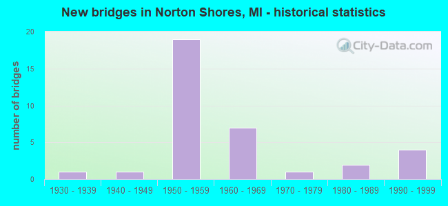
- New bridges - historical statistics
- 11930-1939
- 11940-1949
- 191950-1959
- 71960-1969
- 11970-1979
- 21980-1989
- 41990-1999
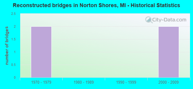
- Reconstructed bridges - Historical Statistics
- 21970-1979
- 01980-1989
- 01990-1999
- 22000-2009
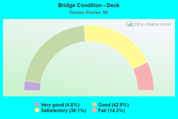
- Bridge Condition - Deck
- 4.8%Very good
- 42.9%Good
- 38.1%Satisfactory
- 14.3%Fair
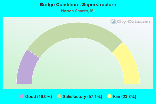
- Bridge Condition - Superstructure
- 19.0%Good
- 57.1%Satisfactory
- 23.8%Fair
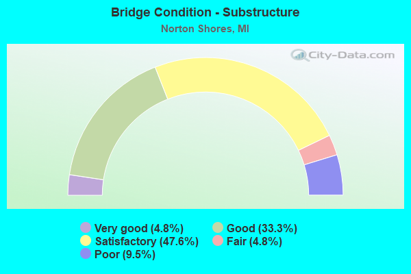
- Bridge Condition - Substructure
- 4.8%Very good
- 33.3%Good
- 47.6%Satisfactory
- 4.8%Fair
- 9.5%Poor
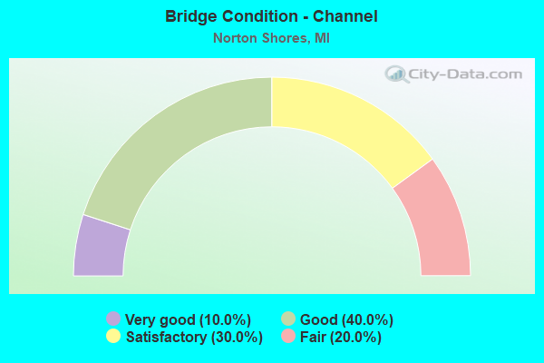
- Bridge Condition - Channel
- 10.0%Very good
- 40.0%Good
- 30.0%Satisfactory
- 20.0%Fair
Find on map >> Show street view
Structure Number: 7568, Location: 1.0 MI N OF I-96 (Lat: 43.187839, Lng: -86.204922), Route carried "on" structure: US 31, Year Built: 1959, Status: Open, Structure Length: 1.82m (5.97ft), Average Daily Traffic: 31,322 (year 2007), Truck Traffic: 5%, Average Future Daily Traffic: 36,129 (year 2018), Design Load: HS 20, Features Intersected: BLACK CREEK
Minimum Vertical Clearance: 30.48m (100.00ft), Kilometerpoint: 7.884, Lanes on structure: 2, Base Highway Network: Yes (Inventory Route: 85, Subroute: 9), Owner: State Highway Agency, Approaching Roadway Width: 12.8m (42.0ft), Skew: 13 degrees, Material/Design: Steel, Design/Construction: Stringer/Multi-beam, Number Of Spans In Main Unit: 1, Length of Maximum Span: 18.2m (59.7ft), Curb-To-Curb Width: 13.1m (43.0ft), Out-to-Out Width: 14.4m (47.2ft)
Condition: Deck: Good, Superstructure: Good, Substructure: Satisfactory, Channel: Satisfactory, Operating Rating: 56.7 metric tons, Method Used To Determine Operating Rating: Load Factor (LF) rating reported by rating factor (RF) method using MS18 loading, Inventory Rating: 34.0 metric tons, Method Used To Determine Inventory Rating: Load Factor (LF) rating reported by rating factor (RF) method using MS18 loading, Structural Evaluation: Equal to present minimum criteria, Deck Geometry: Superior to present desirable criteria, Waterway Adequacy: Equal to present desirable criteria, Approach Roadway Alignment: Equal to present minimum criteria, Designated Inspection Frequency: Every 24 months, Inspection Date: July 2020, Bridge Improvement Cost: $50,000, Deck Structure Type: Concrete Cast-file-Place, Wearing Surface/Protective System: Wearing Surface: Latex Concrete
Find on map >> Show street view
Structure Number: 7569, Location: 1.0 MI N OF I-96 (Lat: 43.187825, Lng: -86.205194), Route carried "on" structure: US 31, Year Built: 1949, Status: Open, Structure Length: 1.82m (5.97ft), Average Daily Traffic: 31,322 (year 2007), Truck Traffic: 5%, Average Future Daily Traffic: 36,129 (year 2018), Design Load: HS 20, Features Intersected: BLACK CREEK
Minimum Vertical Clearance: 30.48m (100.00ft), Kilometerpoint: 7.901, Lanes on structure: 2, Base Highway Network: Yes (Inventory Route: 85, Subroute: 2), Owner: State Highway Agency, Approaching Roadway Width: 12.8m (42.0ft), Skew: 13 degrees, Material/Design: Steel, Design/Construction: Stringer/Multi-beam, Number Of Spans In Main Unit: 1, Length of Maximum Span: 18.2m (59.7ft), Curb-To-Curb Width: 13.1m (43.0ft), Out-to-Out Width: 14.4m (47.2ft)
Condition: Deck: Fair, Superstructure: Satisfactory, Substructure: Satisfactory, Channel: Good, Operating Rating: 97.2 metric tons, Method Used To Determine Operating Rating: Load Factor (LF) rating reported by rating factor (RF) method using MS18 loading, Inventory Rating: 60.9 metric tons, Method Used To Determine Inventory Rating: Load Factor (LF) rating reported by rating factor (RF) method using MS18 loading, Structural Evaluation: Equal to present minimum criteria, Deck Geometry: Superior to present desirable criteria, Waterway Adequacy: Equal to present desirable criteria, Approach Roadway Alignment: Equal to present minimum criteria, Designated Inspection Frequency: Every 24 months, Inspection Date: July 2020, Bridge Improvement Cost: $50,000, Roadway Improvement Cost: $6,000, Total Project Cost: $68,000, Deck Structure Type: Concrete Cast-file-Place, Wearing Surface/Protective System: Wearing Surface: Latex Concrete
Find on map >> Show street view
Structure Number: 7572, Location: 0.7 MI N OF I-96 (Lat: 43.179711, Lng: -86.204961), Route carried "on" structure: City street 2007, Year Built: 1959, Status: Open, Structure Length: 5.78m (18.96ft), Average Daily Traffic: 3,500 (year 2011), Truck Traffic: 2%, Average Future Daily Traffic: 3,875 (year 2033), Design Load: H 15, Features Intersected: US-31, Facility Carried by Structure: SHETTLER RD
Minimum Vertical Clearance: 30.48m (100.00ft), Kilometerpoint: 0.980, Lanes on structure: 2, Lanes under structure: 4, Owner: State Highway Agency, Approaching Roadway Width: 10.3m (33.8ft), Material/Design: Concrete continuous, Design/Construction: Tee Beam, Number Of Spans In Main Unit: 4, Length of Maximum Span: 17.9m (58.7ft), Curb or Sidewalk Widths: Left: 0.8m (2.6ft), Right: 0.8m (2.6ft), Curb-To-Curb Width: 9.1m (29.9ft), Out-to-Out Width: 10.1m (33.1ft)
Condition: Deck: Good, Superstructure: Satisfactory, Substructure: Good, Operating Rating: 50.5 metric tons, Method Used To Determine Operating Rating: Load Factor (LF) rating reported by rating factor (RF) method using MS18 loading, Inventory Rating: 30.1 metric tons, Method Used To Determine Inventory Rating: Load Factor (LF) rating reported by rating factor (RF) method using MS18 loading, Structural Evaluation: Equal to present minimum criteria, Deck Geometry: Meets minimum limits, Underclear: High priority of corrective action, Approach Roadway Alignment: Equal to present minimum criteria, Designated Inspection Frequency: Every 24 months, Inspection Date: August 2021, Deck Structure Type: Concrete Cast-file-Place, Wearing Surface/Protective System: Wearing Surface: Latex Concrete
Find on map >> Show street view
Structure Number: 7573, Location: 2.0 MI N OF I-96 (Lat: 43.200956, Lng: -86.204908), Route carried "on" structure: City street 2007, Year Built: 1959, Status: Open, Structure Length: 5.76m (18.90ft), Average Daily Traffic: 3,900 (year 1988), Average Future Daily Traffic: 3,520 (year 1977), Design Load: H 20, Features Intersected: US-31, Facility Carried by Structure: BROADWAY ST
Minimum Vertical Clearance: 30.48m (100.00ft), Kilometerpoint: 5.971, Lanes on structure: 4, Lanes under structure: 4, Owner: State Highway Agency, Approaching Roadway Width: 16.4m (53.8ft), Material/Design: Concrete continuous, Design/Construction: Tee Beam, Number Of Spans In Main Unit: 4, Length of Maximum Span: 17.9m (58.7ft), Curb or Sidewalk Widths: Left: 1.5m (4.9ft), Right: 1.5m (4.9ft), Curb-To-Curb Width: 14.6m (47.9ft), Out-to-Out Width: 18.4m (60.4ft)
Condition: Deck: Satisfactory, Superstructure: Fair, Substructure: Satisfactory, Operating Rating: 57.3 metric tons, Method Used To Determine Operating Rating: Load Factor (LF) rating reported by rating factor (RF) method using MS18 loading, Inventory Rating: 34.3 metric tons, Method Used To Determine Inventory Rating: Load Factor (LF) rating reported by rating factor (RF) method using MS18 loading, Structural Evaluation: Somewhat better than minimum adequacy, Deck Geometry: High priority of replacement, Underclear: Meets minimum limits, Approach Roadway Alignment: Better than present minimum criteria, Length Of Structure Improvement: 5.76m (18.90ft), Designated Inspection Frequency: Every 24 months, Inspection Date: April 2020, Bridge Improvement Cost: $68,000, Roadway Improvement Cost: $7,000, Total Project Cost: $80,000, Deck Structure Type: Concrete Cast-file-Place, Wearing Surface/Protective System: Wearing Surface: Bituminous
Find on map >> Show street view
Structure Number: 7579, Location: 1.0 MI N OF OTTAWA COL (Lat: 43.132347, Lng: -86.210411), Route carried "on" structure: City street 2007, Year Built: 1958, Status: Open, Structure Length: 5.49m (18.01ft), Average Daily Traffic: 10,850 (year 2016), Truck Traffic: 3%, Average Future Daily Traffic: 12,000 (year 2036), Design Load: H 15, Features Intersected: US-31, Facility Carried by Structure: PONTALUNA
Minimum Vertical Clearance: 30.48m (100.00ft), Kilometerpoint: 13.448, Lanes on structure: 2, Lanes under structure: 4, Owner: State Highway Agency, Approaching Roadway Width: 10.3m (33.8ft), Material/Design: Concrete continuous, Design/Construction: Tee Beam, Number Of Spans In Main Unit: 4, Length of Maximum Span: 16.3m (53.5ft), Curb-To-Curb Width: 9.2m (30.2ft), Out-to-Out Width: 10.1m (33.1ft)
Condition: Deck: Good, Superstructure: Satisfactory, Substructure: Good, Operating Rating: 46.7 metric tons, Method Used To Determine Operating Rating: Load Factor (LF) rating reported by rating factor (RF) method using MS18 loading, Inventory Rating: 27.9 metric tons, Method Used To Determine Inventory Rating: Load Factor (LF) rating reported by rating factor (RF) method using MS18 loading, Structural Evaluation: Equal to present minimum criteria, Deck Geometry: High priority of corrective action, Underclear: High priority of corrective action, Approach Roadway Alignment: Equal to present minimum criteria, Designated Inspection Frequency: Every 24 months, Inspection Date: July 2021, Deck Structure Type: Concrete Cast-file-Place, Wearing Surface/Protective System: Wearing Surface: Latex Concrete
Find on map >> Show street view
Structure Number: 758, Location: 2.5 MI N OF OTTAWA COL (Lat: 43.154236, Lng: -86.211358), Route carried "on" structure: City street 2007, Year Built: 1993, Status: Open, Structure Length: 6.25m (20.51ft), Average Daily Traffic: 2,520 (year 1988), Average Future Daily Traffic: 29,400 (year 2010), Design Load: HS 25 or greater, Features Intersected: US-31, Facility Carried by Structure: STERNBERG RD
Minimum Vertical Clearance: 30.48m (100.00ft), Kilometerpoint: 2.778, Lanes on structure: 5, Lanes under structure: 4, Owner: State Highway Agency, Approaching Roadway Width: 28.6m (93.8ft), Material/Design: Prestressed concrete, Design/Construction: Stringer/Multi-beam, Number Of Spans In Main Unit: 2, Length of Maximum Span: 31.1m (102.0ft), Curb-To-Curb Width: 29.2m (95.8ft), Out-to-Out Width: 30.1m (98.8ft)
Condition: Deck: Good, Superstructure: Satisfactory, Substructure: Satisfactory, Operating Rating: 72.9 metric tons, Method Used To Determine Operating Rating: Load Factor (LF) rating reported by rating factor (RF) method using MS18 loading, Inventory Rating: 41.8 metric tons, Method Used To Determine Inventory Rating: Load Factor (LF) rating reported by rating factor (RF) method using MS18 loading, Structural Evaluation: Equal to present minimum criteria, Deck Geometry: Superior to present desirable criteria, Underclear: High priority of corrective action, Approach Roadway Alignment: Equal to present minimum criteria, Designated Inspection Frequency: Every 24 months, Inspection Date: July 2021, Deck Structure Type: Concrete Cast-file-Place, Wearing Surface/Protective System: Wearing Surface: Monolithic Concrete, Deck Protection: Epoxy Coated Reinforcing
Find on map >> Show street view
Structure Number: 7581, Location: 0.3 MI S OF I-96 (Lat: 43.168825, Lng: -86.208644), Route carried "on" structure: City street 2007, Year Built: 1959, Status: Open, Structure Length: 5.68m (18.64ft), Average Daily Traffic: 2,300 (year 1988), Average Future Daily Traffic: 2,050 (year 1977), Design Load: H 15, Features Intersected: US-31, Facility Carried by Structure: HILE RD
Minimum Vertical Clearance: 30.48m (100.00ft), Kilometerpoint: 1.458, Lanes on structure: 2, Lanes under structure: 5, Owner: State Highway Agency, Approaching Roadway Width: 12.2m (40.0ft), Skew: 2 degrees, Material/Design: Concrete continuous, Design/Construction: Tee Beam, Number Of Spans In Main Unit: 4, Length of Maximum Span: 17.6m (57.7ft), Curb-To-Curb Width: 7.9m (25.9ft), Out-to-Out Width: 10.1m (33.1ft)
Condition: Deck: Satisfactory, Superstructure: Satisfactory, Substructure: Satisfactory, Operating Rating: 56.1 metric tons, Method Used To Determine Operating Rating: Load Factor (LF) rating reported by rating factor (RF) method using MS18 loading, Inventory Rating: 33.7 metric tons, Method Used To Determine Inventory Rating: Load Factor (LF) rating reported by rating factor (RF) method using MS18 loading, Structural Evaluation: Equal to present minimum criteria, Deck Geometry: High priority of corrective action, Underclear: Meets minimum limits, Approach Roadway Alignment: Better than present minimum criteria, Length Of Structure Improvement: 5.67m (18.60ft), Designated Inspection Frequency: Every 24 months, Inspection Date: September 2021, Bridge Improvement Cost: $67,000, Roadway Improvement Cost: $7,000, Total Project Cost: $79,000, Deck Structure Type: Concrete Cast-file-Place, Wearing Surface/Protective System: Wearing Surface: Latex Concrete
Find on map >> Show street view
Structure Number: 7616, Location: 1.3 MI NW OF US-31 (Lat: 43.183814, Lng: -86.223678), Route carried "on" structure: Business Interstate 96, Year Built: 1957, Year Reconstructed: 1981, Status: Open, Structure Length: 1.83m (6.00ft), Average Daily Traffic: 18,500 (year 2013), Truck Traffic: 4%, Average Future Daily Traffic: 20,400 (year 2033), Design Load: HS 20, Features Intersected: BLACK CREEK, Facility Carried by Structure: US-31 BR S
Minimum Vertical Clearance: 30.48m (100.00ft), Kilometerpoint: 1.941, Lanes on structure: 2, Base Highway Network: Yes (Inventory Route: 85, Subroute: 17), Owner: State Highway Agency, Approaching Roadway Width: 13.7m (44.9ft), Skew: 30 degrees, Material/Design: Steel continuous, Design/Construction: Stringer/Multi-beam, Number Of Spans In Main Unit: 3, Length of Maximum Span: 6.1m (20.0ft), Curb-To-Curb Width: 13.9m (45.6ft), Out-to-Out Width: 15.2m (49.9ft)
Condition: Deck: Fair, Superstructure: Fair, Substructure: Poor, Channel: Fair, Operating Rating: 48.6 metric tons, Method Used To Determine Operating Rating: Load Factor (LF) rating reported by rating factor (RF) method using MS18 loading, Inventory Rating: 29.2 metric tons, Method Used To Determine Inventory Rating: Load Factor (LF) rating reported by rating factor (RF) method using MS18 loading, Structural Evaluation: Meets minimum limits, Deck Geometry: Superior to present desirable criteria, Waterway Adequacy: Equal to present desirable criteria, Approach Roadway Alignment: Equal to present minimum criteria, Designated Inspection Frequency: Every 24 months, Other Special Inspection Frequency: Every 12 months, Inspection Date: August 2021, Other Special Inspection Date: August 2021, Deck Structure Type: Concrete Cast-file-Place, Wearing Surface/Protective System: Wearing Surface: Bituminous, Membrane: Preformed Fabric
Find on map >> Show street view
Structure Number: 7617, Location: 1.3 MI NW OF US-31 (Lat: 43.183925, Lng: -86.223569), Route carried "on" structure: Business Interstate 96, Year Built: 1957, Year Reconstructed: 1981, Status: Open, Structure Length: 1.83m (6.00ft), Average Daily Traffic: 18,200 (year 2013), Truck Traffic: 6%, Average Future Daily Traffic: 20,400 (year 2033), Design Load: HS 25 or greater, Features Intersected: BLACK CREEK, Facility Carried by Structure: US-31 BR N
Minimum Vertical Clearance: 30.48m (100.00ft), Kilometerpoint: 1.941, Lanes on structure: 2, Base Highway Network: Yes (Inventory Route: 85, Subroute: 13), Owner: State Highway Agency, Approaching Roadway Width: 13.7m (44.9ft), Skew: 30 degrees, Material/Design: Steel continuous, Design/Construction: Stringer/Multi-beam, Number Of Spans In Main Unit: 3, Length of Maximum Span: 6.1m (20.0ft), Curb-To-Curb Width: 14.0m (45.9ft), Out-to-Out Width: 15.3m (50.2ft)
Condition: Deck: Fair, Superstructure: Fair, Substructure: Poor, Channel: Fair, Operating Rating: 48.9 metric tons, Method Used To Determine Operating Rating: Load Factor (LF) rating reported by rating factor (RF) method using MS18 loading, Inventory Rating: 29.2 metric tons, Method Used To Determine Inventory Rating: Load Factor (LF) rating reported by rating factor (RF) method using MS18 loading, Structural Evaluation: Meets minimum limits, Deck Geometry: Superior to present desirable criteria, Waterway Adequacy: Equal to present desirable criteria, Approach Roadway Alignment: Equal to present minimum criteria, Designated Inspection Frequency: Every 24 months, Other Special Inspection Frequency: Every 12 months, Inspection Date: August 2021, Other Special Inspection Date: August 2021, Deck Structure Type: Concrete Cast-file-Place, Wearing Surface/Protective System: Wearing Surface: Bituminous, Deck Protection: Epoxy Coated Reinforcing
Find on map >> Show street view
Structure Number: 7618, Location: 3.9 MI NW OF US-31 (Lat: 43.201169, Lng: -86.259886), Route carried "on" structure: City street 2007, Year Built: 1955, Status: Open, Structure Length: 5.09m (16.70ft), Average Daily Traffic: 7,300 (year 2014), Average Future Daily Traffic: 8,075 (year 2034), Design Load: HS 20, Features Intersected: US-31 BR, Facility Carried by Structure: BROADWAY AVE
Minimum Vertical Clearance: 30.48m (100.00ft), Kilometerpoint: 1.492, Lanes on structure: 4, Lanes under structure: 4, Owner: State Highway Agency, Approaching Roadway Width: 13.4m (44.0ft), Material/Design: Steel, Design/Construction: Stringer/Multi-beam, Number Of Spans In Main Unit: 4, Length of Maximum Span: 16.4m (53.8ft), Curb or Sidewalk Widths: Left: 2.2m (7.2ft), Right: 2.2m (7.2ft), Curb-To-Curb Width: 13.4m (44.0ft), Out-to-Out Width: 19.0m (62.3ft)
Condition: Deck: Satisfactory, Superstructure: Good, Substructure: Good, Operating Rating: 71.6 metric tons, Method Used To Determine Operating Rating: Load Factor (LF) rating reported by rating factor (RF) method using MS18 loading, Inventory Rating: 43.1 metric tons, Method Used To Determine Inventory Rating: Load Factor (LF) rating reported by rating factor (RF) method using MS18 loading, Structural Evaluation: Better than present minimum criteria, Deck Geometry: High priority of replacement, Underclear: Meets minimum limits, Approach Roadway Alignment: Equal to present desirable criteria, Designated Inspection Frequency: Every 24 months, Inspection Date: April 2020, Bridge Improvement Cost: $61,000, Deck Structure Type: Concrete Cast-file-Place, Wearing Surface/Protective System: Wearing Surface: Latex Concrete
Find on map >> Show street view
Structure Number: 7619, Location: 0.4 MI NW OF US-31 (Lat: 43.176233, Lng: -86.213889), Route carried "on" structure: City street 2007, Year Built: 1959, Year Reconstructed: 2000, Status: Open, Structure Length: 9.08m (29.79ft), Average Daily Traffic: 3,800 (year 1988), Truck Traffic: 5%, Average Future Daily Traffic: 4,370 (year 2008), Design Load: H 15, Features Intersected: US-31 BR, Facility Carried by Structure: AIRPORT RD
Minimum Vertical Clearance: 30.48m (100.00ft), Kilometerpoint: 1.666, Lanes on structure: 2, Lanes under structure: 4, Owner: State Highway Agency, Approaching Roadway Width: 10.3m (33.8ft), Skew: 5 degrees, Material/Design: Steel, Design/Construction: Stringer/Multi-beam, Number Of Spans In Main Unit: 4, Length of Maximum Span: 23.7m (77.8ft), Curb or Sidewalk Widths: Left: 0.9m (3.0ft), Right: 0.9m (3.0ft), Curb-To-Curb Width: 7.9m (25.9ft), Out-to-Out Width: 10.4m (34.1ft)
Condition: Deck: Satisfactory, Superstructure: Satisfactory, Substructure: Satisfactory, Operating Rating: 62.2 metric tons, Method Used To Determine Operating Rating: Load Factor (LF) rating reported by rating factor (RF) method using MS18 loading, Inventory Rating: 37.3 metric tons, Method Used To Determine Inventory Rating: Load Factor (LF) rating reported by rating factor (RF) method using MS18 loading, Structural Evaluation: Equal to present minimum criteria, Deck Geometry: High priority of corrective action, Underclear: Equal to present minimum criteria, Approach Roadway Alignment: Better than present minimum criteria, Length Of Structure Improvement: 9.09m (29.82ft), Designated Inspection Frequency: Every 24 months, Inspection Date: August 2021, Bridge Improvement Cost: $1,521,000, Roadway Improvement Cost: $28,000, Total Project Cost: $334,000, Deck Structure Type: Concrete Cast-file-Place, Wearing Surface/Protective System: Wearing Surface: Latex Concrete
Find on map >> Show street view
Structure Number: 7625, Location: @ US-31 & I-96 INTERCHG (Lat: 43.173106, Lng: -86.205842), Route carried "on" structure: City street 2007, Year Built: 1961, Status: Open, Structure Length: 4.92m (16.14ft), Average Daily Traffic: 5,000 (year 1977), Truck Traffic: 3%, Average Future Daily Traffic: 5,000 (year 1977), Design Load: HS 20+Mod, Features Intersected: US-31, Facility Carried by Structure: AIRLINE ROAD
Minimum Vertical Clearance: 30.48m (100.00ft), Kilometerpoint: 8.416, Lanes on structure: 2, Lanes under structure: 4, Owner: State Highway Agency, Approaching Roadway Width: 12.2m (40.0ft), Skew: 1 degrees, Material/Design: Steel, Design/Construction: Stringer/Multi-beam, Number Of Spans In Main Unit: 4, Length of Maximum Span: 13.9m (45.6ft), Curb-To-Curb Width: 11.6m (38.1ft), Out-to-Out Width: 13.2m (43.3ft)
Condition: Deck: Satisfactory, Superstructure: Satisfactory, Substructure: Fair, Operating Rating: 52.5 metric tons, Method Used To Determine Operating Rating: Load Factor (LF) rating reported by rating factor (RF) method using MS18 loading, Inventory Rating: 31.4 metric tons, Method Used To Determine Inventory Rating: Load Factor (LF) rating reported by rating factor (RF) method using MS18 loading, Structural Evaluation: Somewhat better than minimum adequacy, Deck Geometry: Somewhat better than minimum adequacy, Underclear: Meets minimum limits, Approach Roadway Alignment: Equal to present desirable criteria, Designated Inspection Frequency: Every 24 months, Inspection Date: August 2021, Deck Structure Type: Concrete Cast-file-Place, Wearing Surface/Protective System: Wearing Surface: Latex Concrete
Find on map >> Show street view
Structure Number: 7627, Location: @ US-31 (I-96 UNDER) (Lat: 43.171692, Lng: -86.206722), Route carried "on" structure: US 31, Year Built: 1959, Status: Open, Structure Length: 6.49m (21.29ft), Average Daily Traffic: 62,644 (year 2007), Truck Traffic: 5%, Average Future Daily Traffic: 72,259 (year 2018), Design Load: HS 20, Features Intersected: I-96
Minimum Vertical Clearance: 30.48m (100.00ft), Kilometerpoint: 6.055, Lanes on structure: 6, Lanes under structure: 6, Base Highway Network: Yes (Inventory Route: 85, Subroute: 9), Owner: State Highway Agency, Approaching Roadway Width: 12.2m (40.0ft), Skew: 31 degrees, Material/Design: Steel, Design/Construction: Stringer/Multi-beam, Number Of Spans In Main Unit: 4, Length of Maximum Span: 16.7m (54.8ft), Curb-To-Curb Width: 32.2m (105.6ft), Out-to-Out Width: 33.2m (108.9ft)
Condition: Deck: Satisfactory, Superstructure: Satisfactory, Substructure: Satisfactory, Operating Rating: 86.8 metric tons, Method Used To Determine Operating Rating: Load Factor (LF) rating reported by rating factor (RF) method using MS18 loading, Inventory Rating: 52.2 metric tons, Method Used To Determine Inventory Rating: Load Factor (LF) rating reported by rating factor (RF) method using MS18 loading, Structural Evaluation: Equal to present minimum criteria, Deck Geometry: Superior to present desirable criteria, Underclear: High priority of corrective action, Approach Roadway Alignment: Equal to present minimum criteria, Designated Inspection Frequency: Every 24 months, Inspection Date: April 2020, Deck Structure Type: Concrete Cast-file-Place, Wearing Surface/Protective System: Wearing Surface: Latex Concrete
Find on map >> Show street view
Structure Number: 7628, Location: 0.4 MI SE OF US-31 (Lat: 43.168750, Lng: -86.202447), Route carried "on" structure: Interstate 96, Year Built: 1961, Status: Open, Structure Length: 4.48m (14.70ft), Average Daily Traffic: 22,336 (year 2007), Truck Traffic: 9%, Average Future Daily Traffic: 38,856 (year 2018), Design Load: HS 20, Features Intersected: HILE RD
Minimum Vertical Clearance: 30.48m (100.00ft), Kilometerpoint: 0.472, Lanes on structure: 6, Lanes under structure: 2, Base Highway Network: Yes (Inventory Route: 85, Subroute: 7), Owner: State Highway Agency, Approaching Roadway Width: 15.8m (51.8ft), Skew: 34 degrees, Material/Design: Steel, Design/Construction: Stringer/Multi-beam, Number Of Spans In Main Unit: 3, Length of Maximum Span: 16.7m (54.8ft), Curb-To-Curb Width: 34.2m (112.2ft), Out-to-Out Width: 35.2m (115.5ft)
Condition: Deck: Satisfactory, Superstructure: Fair, Substructure: Satisfactory, Operating Rating: 81.3 metric tons, Method Used To Determine Operating Rating: Load Factor (LF) rating reported by rating factor (RF) method using MS18 loading, Inventory Rating: 48.9 metric tons, Method Used To Determine Inventory Rating: Load Factor (LF) rating reported by rating factor (RF) method using MS18 loading, Structural Evaluation: Somewhat better than minimum adequacy, Deck Geometry: Superior to present desirable criteria, Underclear: Meets minimum limits, Approach Roadway Alignment: Better than present minimum criteria, Designated Inspection Frequency: Every 24 months, Inspection Date: April 2020, Bridge Improvement Cost: $204,000, Deck Structure Type: Concrete Cast-file-Place, Wearing Surface/Protective System: Wearing Surface: Monolithic Concrete
Find on map >> Show street view
Structure Number: 7629, Location: 1.3 MI SE OF US-31 (Lat: 43.154022, Lng: -86.181425), Route carried "on" structure: County highway 6110, Year Built: 1961, Status: Open, Structure Length: 10.00m (32.81ft), Average Daily Traffic: 3,080 (year 1995), Truck Traffic: 5%, Average Future Daily Traffic: 3,542 (year 2015), Design Load: H 15, Features Intersected: I-96, Facility Carried by Structure: STERNBERG RD
Minimum Vertical Clearance: 30.48m (100.00ft), Kilometerpoint: 5.163, Lanes on structure: 2, Lanes under structure: 6, Owner: State Highway Agency, Approaching Roadway Width: 7.3m (24.0ft), Skew: 5 degrees, Material/Design: Steel, Design/Construction: Stringer/Multi-beam, Number Of Spans In Main Unit: 4, Length of Maximum Span: 34.4m (112.9ft), Curb-To-Curb Width: 9.6m (31.5ft), Out-to-Out Width: 10.0m (32.8ft)
Condition: Deck: Good, Superstructure: Satisfactory, Substructure: Good, Operating Rating: 53.5 metric tons, Method Used To Determine Operating Rating: Load Factor (LF) rating reported by rating factor (RF) method using MS18 loading, Inventory Rating: 27.5 metric tons, Method Used To Determine Inventory Rating: Load Factor (LF) rating reported by rating factor (RF) method using MS18 loading, Structural Evaluation: Equal to present minimum criteria, Deck Geometry: Meets minimum limits, Underclear: Meets minimum limits, Approach Roadway Alignment: Better than present minimum criteria, Length Of Structure Improvement: 10.00m (32.81ft), Designated Inspection Frequency: Every 24 months, Inspection Date: July 2020, Bridge Improvement Cost: $269,000, Roadway Improvement Cost: $14,000, Total Project Cost: $163,000, Deck Structure Type: Concrete Cast-file-Place, Wearing Surface/Protective System: Wearing Surface: Latex Concrete
Find on map >> Show street view
Structure Number: 7702, Location: NORTON SHORES (Lat: 43.184317, Lng: -86.223122), Route carried "on" structure: Alternate City street 2007, Year Built: 1931, Status: Open, Structure Length: 1.83m (6.00ft), Average Daily Traffic: 5,583 (year 2020), Truck Traffic: 3%, Average Future Daily Traffic: 6,169 (year 2040), Design Load: HS 20, Features Intersected: BLACK CREEK, Facility Carried by Structure: AIRLINE RD
Minimum Vertical Clearance: 30.48m (100.00ft), Kilometerpoint: 10.336, Lanes on structure: 2, Owner: City or Municipal Highway Agency, Approaching Roadway Width: 12.2m (40.0ft), Material/Design: Steel continuous, Design/Construction: Stringer/Multi-beam, Number Of Spans In Main Unit: 3, Length of Maximum Span: 6.1m (20.0ft), Curb or Sidewalk Widths: Left: 0.9m (3.0ft), Right: 0.9m (3.0ft), Curb-To-Curb Width: 12.2m (40.0ft), Out-to-Out Width: 15.2m (49.9ft)
Condition: Deck: Satisfactory, Superstructure: Fair, Substructure: Satisfactory, Channel: Satisfactory, Operating Rating: 31.8 metric tons, Method Used To Determine Operating Rating: Load Factor (LF) rating reported by rating factor (RF) method using MS18 loading, Inventory Rating: 19.1 metric tons, Method Used To Determine Inventory Rating: Load Factor (LF) rating reported by rating factor (RF) method using MS18 loading, Structural Evaluation: Meets minimum limits, Deck Geometry: Somewhat better than minimum adequacy, Waterway Adequacy: Equal to present desirable criteria, Approach Roadway Alignment: Equal to present desirable criteria, Designated Inspection Frequency: Every 24 months, Inspection Date: May 2021, Deck Structure Type: Concrete Cast-file-Place, Wearing Surface/Protective System: Wearing Surface: Epoxy Overlay
Find on map >> Show street view
Structure Number: 7703, Location: IN NORTON SHORES (Lat: 43.168419, Lng: -86.291147), Route carried "on" structure: City street 2007, Year Built: 1982, Status: Open, Structure Length: 4.27m (14.01ft), Average Daily Traffic: 8,000 (year 2019), Truck Traffic: 3%, Average Future Daily Traffic: 12,000 (year 2039), Design Load: HS 20, Features Intersected: MONA LAKE CHANNEL, Facility Carried by Structure: LAKE HARBOR ROAD
Minimum Vertical Clearance: 30.48m (100.00ft), Kilometerpoint: 4.448, Lanes on structure: 2, Owner: City or Municipal Highway Agency, Approaching Roadway Width: 11.3m (37.1ft), Navigation Control: Yes ( Vertical Clearance: 3.0m (9.8ft), Horizontal Clearance: 13.4m (44.0ft)), Material/Design: Prestressed concrete, Design/Construction: Box Beam or Girders - Multiple, Number Of Spans In Main Unit: 3, Length of Maximum Span: 24.3m (79.7ft), Curb or Sidewalk Widths: Left: 2.5m (8.2ft), Right: 2.5m (8.2ft), Curb-To-Curb Width: 7.9m (25.9ft), Out-to-Out Width: 13.4m (44.0ft)
Condition: Deck: Good, Superstructure: Satisfactory, Substructure: Good, Channel: Very good, Operating Rating: 59.6 metric tons, Method Used To Determine Operating Rating: Load and Resistance Factor Rating (LRFR) rating reported by rating factor(RF) method using HL-93 loadings, Inventory Rating: 37.6 metric tons, Method Used To Determine Inventory Rating: Load and Resistance Factor Rating (LRFR) rating reported by rating factor(RF) method using HL-93 loadings, Structural Evaluation: Equal to present minimum criteria, Deck Geometry: High priority of replacement, Waterway Adequacy: Superior to present desirable criteria, Approach Roadway Alignment: Equal to present desirable criteria, Designated Inspection Frequency: Every 24 months, Inspection Date: May 2021, Deck Structure Type: Other, Wearing Surface/Protective System: Wearing Surface: Bituminous, Membrane: Built-up
Find on map >> Show street view
Structure Number: 7704, Location: 0.5 MI S OF PONTALUNA RD (Lat: 43.126028, Lng: -86.253092), Route carried "on" structure: City street , Year Built: 1997, Status: Open, Structure Length: 0.84m (2.76ft), Average Daily Traffic: 722 (year 1997), Truck Traffic: 3%, Average Future Daily Traffic: 1,300 (year 2010), Design Load: HS 20, Features Intersected: LITTLE BLACK CREEK, Facility Carried by Structure: BLACK LAKE RD
Minimum Vertical Clearance: 30.48m (100.00ft), Kilometerpoint: 1.368, Lanes on structure: 2, Owner: City or Municipal Highway Agency, Approaching Roadway Width: 9.1m (29.9ft), Skew: 1 degrees, Material/Design: Wood or Timber, Design/Construction: Slab, Number Of Spans In Main Unit: 1, Length of Maximum Span: 8.4m (27.6ft), Curb-To-Curb Width: 9.8m (32.2ft), Out-to-Out Width: 10.3m (33.8ft)
Condition: Deck: Good, Superstructure: Good, Substructure: Good, Channel: Good, Operating Rating: 48.2 metric tons, Method Used To Determine Operating Rating: Allowable Stress (AS), Inventory Rating: 34.0 metric tons, Method Used To Determine Inventory Rating: Allowable Stress (AS), Structural Evaluation: Better than present minimum criteria, Deck Geometry: Equal to present minimum criteria, Waterway Adequacy: Meets minimum limits, Approach Roadway Alignment: Somewhat better than minimum adequacy, Designated Inspection Frequency: Every 24 months, Inspection Date: May 2021, Deck Structure Type: Wood or Timber, Wearing Surface/Protective System: Wearing Surface: Bituminous, Membrane: Preformed Fabric
Find on map >> Show street view
Structure Number: 7705, Location: NORTON SHORES (Lat: 43.179425, Lng: -86.263692), Route carried "on" structure: City street 2007, Year Built: 1988, Status: Open, Structure Length: 28.84m (94.62ft), Average Daily Traffic: 25,000 (year 2016), Truck Traffic: 5%, Average Future Daily Traffic: 30,000 (year 2036), Design Load: HS 20, Features Intersected: MONA LAKE, Facility Carried by Structure: HENRY STREET
Minimum Vertical Clearance: 30.48m (100.00ft), Kilometerpoint: 5.181, Lanes on structure: 2, Base Highway Network: Yes (Inventory Route: 86, Subroute: 4), Owner: City or Municipal Highway Agency, Approaching Roadway Width: 11.0m (36.1ft), Material/Design: Prestressed concrete, Design/Construction: Box Beam or Girders - Multiple, Number Of Spans In Main Unit: 19, Length of Maximum Span: 21.3m (69.9ft), Curb or Sidewalk Widths: Left: 1.9m (6.2ft), Right: 1.9m (6.2ft), Curb-To-Curb Width: 14.6m (47.9ft), Out-to-Out Width: 19.3m (63.3ft)
Condition: Deck: Good, Superstructure: Satisfactory, Substructure: Good, Channel: Good, Operating Rating: 48.9 metric tons, Method Used To Determine Operating Rating: Load and Resistance Factor Rating (LRFR) rating reported by rating factor(RF) method using HL-93 loadings, Inventory Rating: 30.5 metric tons, Method Used To Determine Inventory Rating: Load and Resistance Factor Rating (LRFR) rating reported by rating factor(RF) method using HL-93 loadings, Structural Evaluation: Equal to present minimum criteria, Deck Geometry: Superior to present desirable criteria, Waterway Adequacy: Equal to present desirable criteria, Approach Roadway Alignment: Equal to present desirable criteria, Designated Inspection Frequency: Every 24 months, Underwater Inspection Frequency: Every 24 months, Inspection Date: May 2021, Underwater Inspection Date: July 2021, Deck Structure Type: Concrete Cast-file-Place, Wearing Surface/Protective System: Wearing Surface: Epoxy Overlay, Deck Protection: Epoxy Coated Reinforcing
Find on map >> Show street view
Structure Number: 7706, Location: 0.5 MI S OF PONTALUNA RD (Lat: 43.127536, Lng: -86.235719), Route carried "on" structure: City street , Year Built: 1999, Status: Open, Structure Length: 1.31m (4.30ft), Average Daily Traffic: 400 (year 1999), Average Future Daily Traffic: 670 (year 2015), Design Load: HS 20, Features Intersected: YONKERS DRAIN, Facility Carried by Structure: WOOD RD
Minimum Vertical Clearance: 30.48m (100.00ft), Kilometerpoint: 1.048, Lanes on structure: 2, Owner: City or Municipal Highway Agency, Approaching Roadway Width: 9.8m (32.2ft), Material/Design: Prestressed concrete, Design/Construction: Box Beam or Girders - Multiple, Number Of Spans In Main Unit: 1, Length of Maximum Span: 11.6m (38.1ft), Curb-To-Curb Width: 10.1m (33.1ft), Out-to-Out Width: 10.4m (34.1ft)
Condition: Deck: Very good, Superstructure: Satisfactory, Substructure: Very good, Channel: Satisfactory, Operating Rating: 62.7 metric tons, Method Used To Determine Operating Rating: Load Factor (LF), Inventory Rating: 37.6 metric tons, Method Used To Determine Inventory Rating: Load Factor (LF), Structural Evaluation: Equal to present minimum criteria, Deck Geometry: Better than present minimum criteria, Waterway Adequacy: Better than present minimum criteria, Approach Roadway Alignment: Better than present minimum criteria, Designated Inspection Frequency: Every 24 months, Inspection Date: May 2021, Deck Structure Type: Concrete Cast-file-Place
Find on map >> Show street view
Structure Number: 8916, Location: SECTION 3 SPRING LAKE TWP (Lat: 43.112172, Lng: -86.190628), Route carried "on" structure: County highway , Year Built: 1977, Year Reconstructed: 2013, Status: Open, Structure Length: 6.78m (22.24ft), Average Daily Traffic: 1,160 (year 2020), Truck Traffic: 5%, Average Future Daily Traffic: 2,100 (year 2040), Design Load: Greater than HL93, Features Intersected: CORNELIUS BAYOU, Facility Carried by Structure: W SPRING LAKE RD
Minimum Vertical Clearance: 30.48m (100.00ft), Kilometerpoint: 4.040, Lanes on structure: 2, Owner: County Highway Agency, Approaching Roadway Width: 9.5m (31.2ft), Material/Design: Prestressed concrete, Design/Construction: Box Beam or Girders - Multiple, Number Of Spans In Main Unit: 5, Length of Maximum Span: 13.1m (43.0ft), Curb-To-Curb Width: 9.5m (31.2ft), Out-to-Out Width: 13.4m (44.0ft)
Condition: Deck: Good, Superstructure: Good, Substructure: Satisfactory, Channel: Good, Operating Rating: 80.4 metric tons, Method Used To Determine Operating Rating: Load and Resistance Factor Rating (LRFR) rating reported by rating factor(RF) method using HL-93 loadings, Inventory Rating: 60.6 metric tons, Method Used To Determine Inventory Rating: Load and Resistance Factor Rating (LRFR) rating reported by rating factor(RF) method using HL-93 loadings, Structural Evaluation: Equal to present minimum criteria, Deck Geometry: Somewhat better than minimum adequacy, Waterway Adequacy: Equal to present desirable criteria, Approach Roadway Alignment: Equal to present desirable criteria, Designated Inspection Frequency: Every 24 months, Underwater Inspection Frequency: Every 60 months, Inspection Date: November 2020, Underwater Inspection Date: August 2018, Deck Structure Type: Concrete Precast Panels, Wearing Surface/Protective System: Wearing Surface: Integral Concrete, Deck Protection: Epoxy Coated Reinforcing
Find on map >> Show street view
Structure Number: 7572, Location: 0.7 MI N OF I-96 (Lat: 43.179711, Lng: -86.204961), Route carried "under" structure: US 31, Year Built: 1959, Structure Length: 0. m, Average Daily Traffic: 55,200 (year 2011), Truck Traffic: 5%, Features Intersected: US-31, Facility Carried by Structure: SHETTLER RD
Minimum Vertical Clearance: 4.85m (15.91ft), Kilometerpoint: 6.982, Lanes on structure: 2, Lanes under structure: 4, Material/Design: Concrete continuous, Design/Construction: Tee Beam, Length of Maximum Span: 17.9m (58.7ft)
Find on map >> Show street view
Structure Number: 7573, Location: 2.0 MI N OF I-96 (Lat: 43.200956, Lng: -86.204908), Route carried "under" structure: US 31, Year Built: 1959, Structure Length: 0. m, Average Daily Traffic: 62,644 (year 2007), Truck Traffic: 5%, Features Intersected: US-31, Facility Carried by Structure: BROADWAY ST
Minimum Vertical Clearance: 5.05m (16.57ft), Kilometerpoint: 9.343, Lanes on structure: 4, Lanes under structure: 4, Material/Design: Concrete continuous, Design/Construction: Tee Beam, Length of Maximum Span: 17.9m (58.7ft)
Find on map >> Show street view
Structure Number: 7579, Location: 1.0 MI N OF OTTAWA COL (Lat: 43.132347, Lng: -86.210411), Route carried "under" structure: US 31, Year Built: 1958, Structure Length: 0. m, Average Daily Traffic: 37,717 (year 2014), Truck Traffic: 4%, Features Intersected: US-31, Facility Carried by Structure: PONTALUNA
Minimum Vertical Clearance: 4.60m (15.09ft), Kilometerpoint: 1.617, Lanes on structure: 2, Lanes under structure: 4, Material/Design: Concrete continuous, Design/Construction: Tee Beam, Length of Maximum Span: 16.3m (53.5ft)
Find on map >> Show street view
Structure Number: 758, Location: 2.5 MI N OF OTTAWA COL (Lat: 43.154236, Lng: -86.211358), Route carried "under" structure: US 31, Year Built: 1993, Structure Length: 0. m, Average Daily Traffic: 49,602 (year 2007), Truck Traffic: 4%, Features Intersected: US-31, Facility Carried by Structure: STERNBERG RD
Minimum Vertical Clearance: 4.95m (16.24ft), Kilometerpoint: 4.049, Lanes on structure: 5, Lanes under structure: 4, Material/Design: Prestressed concrete, Design/Construction: Stringer/Multi-beam, Length of Maximum Span: 31.1m (102.0ft)
Find on map >> Show street view
Structure Number: 7581, Location: 0.3 MI S OF I-96 (Lat: 43.168825, Lng: -86.208644), Route carried "under" structure: US 31, Year Built: 1959, Structure Length: 0. m, Average Daily Traffic: 49,602 (year 2007), Truck Traffic: 4%, Features Intersected: US-31, Facility Carried by Structure: HILE RD
Minimum Vertical Clearance: 4.85m (15.91ft), Kilometerpoint: 5.710, Lanes on structure: 2, Lanes under structure: 5, Material/Design: Concrete continuous, Design/Construction: Tee Beam, Length of Maximum Span: 17.6m (57.7ft)
Find on map >> Show street view
Structure Number: 7618, Location: 3.9 MI NW OF US-31 (Lat: 43.201169, Lng: -86.259886), Route carried "under" structure: Business Interstate 96, Year Built: 1955, Structure Length: 0. m, Average Daily Traffic: 18,900 (year 2014), Truck Traffic: 4%, Features Intersected: US-31 BR, Facility Carried by Structure: BROADWAY AVE
Minimum Vertical Clearance: 4.50m (14.76ft), Kilometerpoint: 6.244, Lanes on structure: 4, Lanes under structure: 4, Material/Design: Steel, Design/Construction: Stringer/Multi-beam, Length of Maximum Span: 16.4m (53.8ft)
Find on map >> Show street view
Structure Number: 7619, Location: 0.4 MI NW OF US-31 (Lat: 43.176233, Lng: -86.213889), Route carried "under" structure: Business Interstate 96, Year Built: 1959, Structure Length: 0. m, Average Daily Traffic: 20,498 (year 2007), Truck Traffic: 6%, Features Intersected: US-31 BR, Facility Carried by Structure: AIRPORT RD
Minimum Vertical Clearance: 4.90m (16.08ft), Kilometerpoint: 0.756, Lanes on structure: 2, Lanes under structure: 4, Material/Design: Steel, Design/Construction: Stringer/Multi-beam, Length of Maximum Span: 23.7m (77.8ft)
Find on map >> Show street view
Structure Number: 7621, Location: 4.1 MI NW OF US-31 (Lat: 43.202633, Lng: -86.259858), Route carried "under" structure: Business Interstate 96, Year Built: 1958, Structure Length: 0. m, Average Daily Traffic: 17,550 (year 2007), Truck Traffic: 6%, Features Intersected: US-31 BR, Facility Carried by Structure: MI SHORE
Minimum Vertical Clearance: 4.60m (15.09ft), Kilometerpoint: 6.407, Lanes under structure: 4, Material/Design: Steel, Design/Construction: Stringer/Multi-beam, Length of Maximum Span: 19.2m (63.0ft)
Find on map >> Show street view
Structure Number: 7622, Location: 0.7 MI NW OF US-31 (Lat: 43.177842, Lng: -86.216642), Route carried "under" structure: Business Interstate 96, Year Built: 1959, Structure Length: 0. m, Average Daily Traffic: 20,498 (year 2007), Truck Traffic: 6%, Features Intersected: US-31 BR, Facility Carried by Structure: CSX RR
Minimum Vertical Clearance: 4.60m (15.09ft), Kilometerpoint: 1.059, Lanes under structure: 4, Material/Design: Steel, Design/Construction: Girder and Floorbeam System, Length of Maximum Span: 31.7m (104.0ft)
Find on map >> Show street view
Structure Number: 7625, Location: @ US-31 & I-96 INTERCHG (Lat: 43.173106, Lng: -86.205842), Route carried "under" structure: US 31, Year Built: 1961, Structure Length: 0. m, Average Daily Traffic: 62,644 (year 2007), Truck Traffic: 5%, Features Intersected: US-31, Facility Carried by Structure: AIRLINE ROAD
Minimum Vertical Clearance: 4.47m (14.67ft), Kilometerpoint: 6.238, Lanes on structure: 2, Lanes under structure: 4, Material/Design: Steel, Design/Construction: Stringer/Multi-beam, Length of Maximum Span: 13.9m (45.6ft)
Find on map >> Show street view
Structure Number: 7626, Location: @ US-31 & I-96 INTERCHG (Lat: 43.172981, Lng: -86.204900), Route carried "under" structure: Ramp Interstate 96, Year Built: 1961, Structure Length: 0. m, Average Daily Traffic: 6,000 (year 1988), Features Intersected: US-31 RAMP, Facility Carried by Structure: AIRLINE ROAD
Minimum Vertical Clearance: 30+ m (98+ ft), Kilometerpoint: 0.457, Lanes on structure: 2, Lanes under structure: 2, Material/Design: Steel, Design/Construction: Stringer/Multi-beam, Length of Maximum Span: 14.3m (46.9ft)
Find on map >> Show street view
Structure Number: 7627, Location: @ US-31 (I-96 UNDER) (Lat: 43.171692, Lng: -86.206722), Route carried "under" structure: Interstate 96, Year Built: 1959, Structure Length: 0. m, Average Daily Traffic: 22,336 (year 2007), Truck Traffic: 9%, Features Intersected: I-96, Facility Carried by Structure: US-31
Minimum Vertical Clearance: 4.44m (14.57ft), Kilometerpoint: 0.016, Lanes on structure: 6, Lanes under structure: 6, Material/Design: Steel, Design/Construction: Stringer/Multi-beam, Length of Maximum Span: 16.7m (54.8ft)
Find on map >> Show street view
Structure Number: 7628, Location: 0.4 MI SE OF US-31 (Lat: 43.168750, Lng: -86.202447), Route carried "under" structure: County highway , Year Built: 1961, Structure Length: 0. m, Average Daily Traffic: 3,501 (year 1991), Features Intersected: HILE RD, Facility Carried by Structure: I-96
Minimum Vertical Clearance: 4.57m (14.99ft), Kilometerpoint: 1.938, Lanes on structure: 6, Lanes under structure: 2, Material/Design: Steel, Design/Construction: Stringer/Multi-beam, Length of Maximum Span: 16.7m (54.8ft)
Find on map >> Show street view
Structure Number: 7629, Location: 1.3 MI SE OF US-31 (Lat: 43.154022, Lng: -86.181425), Route carried "under" structure: Interstate 96, Year Built: 1961, Structure Length: 0. m, Average Daily Traffic: 22,336 (year 2007), Truck Traffic: 9%, Features Intersected: I-96, Facility Carried by Structure: STERNBERG RD
Minimum Vertical Clearance: 4.90m (16.08ft), Kilometerpoint: 2.826, Lanes on structure: 2, Lanes under structure: 6, Material/Design: Steel, Design/Construction: Stringer/Multi-beam, Length of Maximum Span: 34.4m (112.9ft)