Bridge Statistics for O'Fallon, Illinois (IL)
Condition, Traffic, Stress, Structural Evaluation, Project Costs
- National Bridge Inventory (NBI) Statistics
- 35Number of bridges
- 348ft / 106mTotal length
- $348,000Total costs
- 502,575Total average daily traffic
- 66,402Total average daily truck traffic
- National Bridge Inventory (NBI) Registered Bridges for O'Fallon
- No street view available for this location
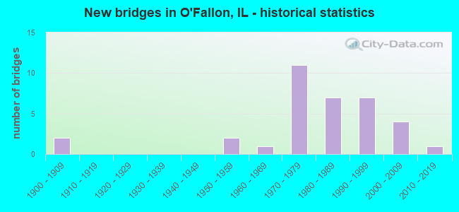
- New bridges - historical statistics
- 21900-1909
- 21950-1959
- 11960-1969
- 111970-1979
- 71980-1989
- 71990-1999
- 42000-2009
- 12010-2019

- Reconstructed bridges - Historical Statistics
- 11970-1979
- 11980-1989
- 11990-1999
- 22000-2009


- Bridge Condition - Deck
- 5.0%Excellent
- 15.0%Very good
- 50.0%Good
- 20.0%Satisfactory
- 5.0%Fair
- 5.0%Serious

- Bridge Condition - Superstructure
- 4.8%Excellent
- 14.3%Very good
- 42.9%Good
- 23.8%Satisfactory
- 4.8%Fair
- 9.5%Serious

- Bridge Condition - Substructure
- 4.8%Excellent
- 14.3%Very good
- 61.9%Good
- 19.0%Satisfactory

- Bridge Condition - Channel
- 27.8%Very good
- 33.3%Good
- 27.8%Satisfactory
- 11.1%Fair

- Bridge Condition - Culverts
- 33.3%Very good
- 33.3%Good
- 33.3%Satisfactory
Find on map >> Show street view
Structure Number: 603022, Location: 3.3MI S TROY (Lat: 38.667694, Lng: -89.876167), Route carried "on" structure: County highway , Year Built: 1956, Year Reconstructed: 1994, Status: Open, Structure Length: 3.29m (10.79ft), Average Daily Traffic: 8,050 (year 2021), Truck Traffic: 10%, Average Future Daily Traffic: 8,692 (year 2032), Design Load: HS 15, Features Intersected: MILL CK, Facility Carried by Structure: FAS 1937/TROY OFAL
Minimum Vertical Clearance: 30+ m (98+ ft), Kilometerpoint: 3.943, Lanes on structure: 2, Base Highway Network: Yes, Owner: County Highway Agency, Approaching Roadway Width: 7.6m (24.9ft), Material/Design: Prestressed concrete, Design/Construction: Box Beam or Girders - Multiple, Number Of Spans In Main Unit: 3, Length of Maximum Span: 11.0m (36.1ft), Curb-To-Curb Width: 12.6m (41.3ft), Out-to-Out Width: 12.6m (41.3ft)
Condition: Deck: Serious, Superstructure: Serious, Substructure: Satisfactory, Channel: Satisfactory, Operating Rating: 51.8 metric tons, Method Used To Determine Operating Rating: Load Factor (LF) rating reported by rating factor (RF) method using MS18 loading, Inventory Rating: 31.1 metric tons, Method Used To Determine Inventory Rating: Load Factor (LF) rating reported by rating factor (RF) method using MS18 loading, Structural Evaluation: High priority of corrective action, Deck Geometry: Somewhat better than minimum adequacy, Waterway Adequacy: Equal to present desirable criteria, Approach Roadway Alignment: Equal to present desirable criteria, Designated Inspection Frequency: Every 24 months, Inspection Date: September 2020, Deck Structure Type: Concrete Precast Panels, Wearing Surface/Protective System: Wearing Surface: Bituminous
Find on map >> Show street view
Structure Number: 820179, Location: 2.31 MI E OF ILL 159 (Lat: 38.592403, Lng: -89.944906), Route carried "on" structure: Other road , Year Built: 1972, Year Reconstructed: 1999, Status: Open, Structure Length: 9.91m (32.51ft), Average Daily Traffic: 14,650 (year 2018), Truck Traffic: 7%, Average Future Daily Traffic: 14,173 (year 2032), Design Load: HS 20, Features Intersected: FAI 64, Facility Carried by Structure: OLD US 50
Minimum Vertical Clearance: 30+ m (98+ ft), Kilometerpoint: 8.867, Lanes on structure: 2, Lanes under structure: 2, Base Highway Network: Yes, Owner: State Highway Agency, Approaching Roadway Width: 20.7m (67.9ft), Skew: 34 degrees, Material/Design: Steel continuous, Design/Construction: Stringer/Multi-beam, Number Of Spans In Main Unit: 2, Number Of Approach Spans: 2, Length of Maximum Span: 36.6m (120.1ft), Curb-To-Curb Width: 27.0m (88.6ft), Out-to-Out Width: 28.0m (91.9ft)
Condition: Deck: Good, Superstructure: Good, Substructure: Good, Operating Rating: 76.5 metric tons, Method Used To Determine Operating Rating: Load Factor (LF) rating reported by rating factor (RF) method using MS18 loading, Inventory Rating: 47.6 metric tons, Method Used To Determine Inventory Rating: Load Factor (LF) rating reported by rating factor (RF) method using MS18 loading, Structural Evaluation: Better than present minimum criteria, Deck Geometry: Superior to present desirable criteria, Underclear: Meets minimum limits, Approach Roadway Alignment: Equal to present desirable criteria, Designated Inspection Frequency: Every 24 months, Inspection Date: Febuary 2021, Deck Structure Type: Concrete Cast-file-Place, Wearing Surface/Protective System: Wearing Surface: Other
Find on map >> Show street view
Structure Number: 820181, Location: 3.74 MI S OF US-50 (Lat: 38.575381, Lng: -89.909458), Route carried "on" structure: Other road , Year Built: 1971, Year Reconstructed: 2005, Status: Open, Structure Length: 5.89m (19.32ft), Average Daily Traffic: 10,100 (year 2018), Truck Traffic: 3%, Average Future Daily Traffic: 10,565 (year 2032), Design Load: HS 20, Features Intersected: FAI-64, Facility Carried by Structure: S Lincoln Ave /CH
Minimum Vertical Clearance: 30+ m (98+ ft), Kilometerpoint: 9.028, Lanes on structure: 2, Lanes under structure: 4, Base Highway Network: Yes, Owner: State Highway Agency, Approaching Roadway Width: 9.1m (29.9ft), Material/Design: Steel continuous, Design/Construction: Stringer/Multi-beam, Number Of Spans In Main Unit: 2, Number Of Approach Spans: 2, Length of Maximum Span: 29.9m (98.1ft), Curb-To-Curb Width: 13.0m (42.7ft), Out-to-Out Width: 14.0m (45.9ft)
Condition: Deck: Good, Superstructure: Good, Substructure: Good, Operating Rating: 85.9 metric tons, Method Used To Determine Operating Rating: Load Factor (LF) rating reported by rating factor (RF) method using MS18 loading, Inventory Rating: 51.5 metric tons, Method Used To Determine Inventory Rating: Load Factor (LF) rating reported by rating factor (RF) method using MS18 loading, Structural Evaluation: Better than present minimum criteria, Deck Geometry: Somewhat better than minimum adequacy, Underclear: Somewhat better than minimum adequacy, Approach Roadway Alignment: Equal to present desirable criteria, Designated Inspection Frequency: Every 24 months, Inspection Date: Febuary 2021, Deck Structure Type: Concrete Cast-file-Place, Wearing Surface/Protective System: Wearing Surface: Other
Find on map >> Show street view
Structure Number: 820183, Location: 0.58 MI NE OF SHILOH (Lat: 38.572358, Lng: -89.876444), Route carried "on" structure: State highway 158, Year Built: 1973, Status: Open, Structure Length: 5.41m (17.75ft), Average Daily Traffic: 14,900 (year 2021), Truck Traffic: 7%, Average Future Daily Traffic: 9,780 (year 2032), Design Load: HS 20, Features Intersected: FAI 64
Minimum Vertical Clearance: 30+ m (98+ ft), Kilometerpoint: 40.297, Lanes on structure: 2, Lanes under structure: 4, Base Highway Network: Yes, Owner: State Highway Agency, Approaching Roadway Width: 16.5m (54.1ft), Material/Design: Steel continuous, Design/Construction: Stringer/Multi-beam, Number Of Spans In Main Unit: 2, Number Of Approach Spans: 2, Length of Maximum Span: 26.8m (87.9ft), Curb-To-Curb Width: 15.4m (50.5ft), Out-to-Out Width: 16.5m (54.1ft)
Condition: Deck: Good, Superstructure: Good, Substructure: Good, Operating Rating: 71.9 metric tons, Method Used To Determine Operating Rating: Load Factor (LF) rating reported by rating factor (RF) method using MS18 loading, Inventory Rating: 35.6 metric tons, Method Used To Determine Inventory Rating: Load Factor (LF) rating reported by rating factor (RF) method using MS18 loading, Structural Evaluation: Better than present minimum criteria, Deck Geometry: Superior to present desirable criteria, Underclear: Meets minimum limits, Approach Roadway Alignment: Equal to present desirable criteria, Designated Inspection Frequency: Every 24 months, Inspection Date: Febuary 2021, Deck Structure Type: Concrete Cast-file-Place, Wearing Surface/Protective System: Wearing Surface: Other
Find on map >> Show street view
Structure Number: 820184, Location: 0.58 MI NE OF SHILOH (Lat: 38.572464, Lng: -89.876411), Route carried "on" structure: State highway 158, Year Built: 1973, Status: Open, Structure Length: 5.41m (17.75ft), Average Daily Traffic: 14,900 (year 2021), Truck Traffic: 7%, Average Future Daily Traffic: 9,780 (year 2032), Design Load: HS 20, Features Intersected: FAI 64
Minimum Vertical Clearance: 30+ m (98+ ft), Kilometerpoint: 40.313, Lanes on structure: 2, Lanes under structure: 4, Base Highway Network: Yes, Owner: State Highway Agency, Approaching Roadway Width: 16.5m (54.1ft), Material/Design: Steel continuous, Design/Construction: Stringer/Multi-beam, Number Of Spans In Main Unit: 2, Number Of Approach Spans: 2, Length of Maximum Span: 27.1m (88.9ft), Curb-To-Curb Width: 15.4m (50.5ft), Out-to-Out Width: 16.5m (54.1ft)
Condition: Deck: Satisfactory, Superstructure: Good, Substructure: Good, Operating Rating: 71.3 metric tons, Method Used To Determine Operating Rating: Load Factor (LF) rating reported by rating factor (RF) method using MS18 loading, Inventory Rating: 35.6 metric tons, Method Used To Determine Inventory Rating: Load Factor (LF) rating reported by rating factor (RF) method using MS18 loading, Structural Evaluation: Better than present minimum criteria, Deck Geometry: Superior to present desirable criteria, Underclear: High priority of corrective action, Approach Roadway Alignment: Equal to present desirable criteria, Designated Inspection Frequency: Every 24 months, Inspection Date: Febuary 2021, Deck Structure Type: Concrete Cast-file-Place, Wearing Surface/Protective System: Wearing Surface: Other
Find on map >> Show street view
Structure Number: 820268, Location: EAST O'FALLON (Lat: 38.580897, Lng: -89.890786), Route carried "on" structure: Other road , Year Built: 1952, Year Reconstructed: 1981, Status: Open, Structure Length: 1.83m (6.00ft), Average Daily Traffic: 10,300 (year 2018), Truck Traffic: 4%, Average Future Daily Traffic: 10,355 (year 2032), Design Load: HS 20, Features Intersected: ROCK SPRING BROOK, Facility Carried by Structure: OLD US 50
Minimum Vertical Clearance: 30+ m (98+ ft), Kilometerpoint: 13.953, Lanes on structure: 2, Base Highway Network: Yes, Owner: State Highway Agency, Approaching Roadway Width: 7.9m (25.9ft), Material/Design: Prestressed concrete, Design/Construction: Box Beam or Girders - Multiple, Number Of Spans In Main Unit: 1, Length of Maximum Span: 17.1m (56.1ft), Curb-To-Curb Width: 12.6m (41.3ft), Out-to-Out Width: 12.8m (42.0ft)
Condition: Deck: Satisfactory, Superstructure: Satisfactory, Substructure: Good, Channel: Good, Operating Rating: 56.7 metric tons, Method Used To Determine Operating Rating: Load Factor (LF) rating reported by rating factor (RF) method using MS18 loading, Inventory Rating: 35.3 metric tons, Method Used To Determine Inventory Rating: Load Factor (LF) rating reported by rating factor (RF) method using MS18 loading, Structural Evaluation: Equal to present minimum criteria, Deck Geometry: Somewhat better than minimum adequacy, Waterway Adequacy: Equal to present minimum criteria, Approach Roadway Alignment: Equal to present desirable criteria, Designated Inspection Frequency: Every 24 months, Inspection Date: September 2020, Deck Structure Type: Concrete Precast Panels, Wearing Surface/Protective System: Wearing Surface: Bituminous, Membrane: Built-up
Find on map >> Show street view
Structure Number: 82028, Location: 1 MI. E. OF O'FALLON (Lat: 38.589558, Lng: -89.857008), Route carried "on" structure: US 50, Year Built: 1989, Status: Open, Structure Length: 12.00m (39.37ft), Average Daily Traffic: 13,000 (year 2021), Truck Traffic: 11%, Average Future Daily Traffic: 14,853 (year 2032), Design Load: H 20, Features Intersected: B&O RR
Minimum Vertical Clearance: 30+ m (98+ ft), Kilometerpoint: 47.555, Lanes on structure: 2, Base Highway Network: Yes, Owner: State Highway Agency, Approaching Roadway Width: 9.1m (29.9ft), Skew: 5 degrees, Material/Design: Steel continuous, Design/Construction: Stringer/Multi-beam, Number Of Spans In Main Unit: 3, Length of Maximum Span: 48.4m (158.8ft), Curb-To-Curb Width: 9.8m (32.2ft), Out-to-Out Width: 10.7m (35.1ft)
Condition: Deck: Good, Superstructure: Satisfactory, Substructure: Good, Operating Rating: 77.1 metric tons, Method Used To Determine Operating Rating: Load Factor (LF) rating reported by rating factor (RF) method using MS18 loading, Inventory Rating: 46.3 metric tons, Method Used To Determine Inventory Rating: Load Factor (LF) rating reported by rating factor (RF) method using MS18 loading, Structural Evaluation: Equal to present minimum criteria, Deck Geometry: Meets minimum limits, Underclear: Superior to present desirable criteria, Approach Roadway Alignment: Equal to present desirable criteria, Designated Inspection Frequency: Every 24 months, Inspection Date: July 2021, Deck Structure Type: Concrete Cast-file-Place, Wearing Surface/Protective System: Deck Protection: Epoxy Coated Reinforcing
Find on map >> Show street view
Structure Number: 820309, Location: 1.02MI E OF ILL 159 (Lat: 38.598728, Lng: -89.966103), Route carried "on" structure: Interstate 64, Year Built: 2007, Status: Open, Structure Length: 4.65m (15.26ft), Average Daily Traffic: 39,400 (year 2021), Truck Traffic: 14%, Average Future Daily Traffic: 36,662 (year 2032), Design Load: HS 20, Features Intersected: OLD COLLINSVILLE RD
Minimum Vertical Clearance: 30+ m (98+ ft), Kilometerpoint: 21.146, Lanes on structure: 3, Lanes under structure: 3, Base Highway Network: Yes, Owner: State Highway Agency, Approaching Roadway Width: 20.7m (67.9ft), Material/Design: Steel continuous, Design/Construction: Stringer/Multi-beam, Number Of Spans In Main Unit: 3, Length of Maximum Span: 17.7m (58.1ft), Curb-To-Curb Width: 19.7m (64.6ft), Out-to-Out Width: 20.7m (67.9ft)
Condition: Deck: Very good, Superstructure: Very good, Substructure: Very good, Operating Rating: 82.0 metric tons, Method Used To Determine Operating Rating: Load Factor (LF) rating reported by rating factor (RF) method using MS18 loading, Inventory Rating: 49.2 metric tons, Method Used To Determine Inventory Rating: Load Factor (LF) rating reported by rating factor (RF) method using MS18 loading, Structural Evaluation: Equal to present desirable criteria, Deck Geometry: Superior to present desirable criteria, Underclear: Meets minimum limits, Approach Roadway Alignment: Equal to present desirable criteria, Designated Inspection Frequency: Every 24 months, Inspection Date: Febuary 2021, Deck Structure Type: Concrete Cast-file-Place, Wearing Surface/Protective System: Deck Protection: Epoxy Coated Reinforcing
Find on map >> Show street view
Structure Number: 820344, Location: .87 MI S OF US 50 (Lat: 38.576261, Lng: -89.929097), Route carried "on" structure: Other road , Year Built: 2001, Year Reconstructed: 2012, Status: Open, Structure Length: 8.54m (28.02ft), Average Daily Traffic: 10,850 (year 2021), Truck Traffic: 3%, Average Future Daily Traffic: 20,093 (year 2032), Design Load: HS 20, Features Intersected: FAI 64, Facility Carried by Structure: N GREENMOUNT RD
Minimum Vertical Clearance: 30+ m (98+ ft), Kilometerpoint: 1.786, Lanes on structure: 2, Lanes under structure: 4, Base Highway Network: Yes, Owner: State Highway Agency, Approaching Roadway Width: 13.4m (44.0ft), Skew: 32 degrees, Material/Design: Steel continuous, Design/Construction: Stringer/Multi-beam, Number Of Spans In Main Unit: 2, Length of Maximum Span: 12.6m (41.3ft), Curb-To-Curb Width: 19.9m (65.3ft), Out-to-Out Width: 20.9m (68.6ft)
Condition: Deck: Very good, Superstructure: Good, Substructure: Very good, Operating Rating: 74.8 metric tons, Method Used To Determine Operating Rating: Load Factor (LF) rating reported by rating factor (RF) method using MS18 loading, Inventory Rating: 45.0 metric tons, Method Used To Determine Inventory Rating: Load Factor (LF) rating reported by rating factor (RF) method using MS18 loading, Structural Evaluation: Better than present minimum criteria, Deck Geometry: Superior to present desirable criteria, Underclear: Equal to present minimum criteria, Approach Roadway Alignment: Equal to present desirable criteria, Designated Inspection Frequency: Every 24 months, Inspection Date: Febuary 2021, Deck Structure Type: Concrete Cast-file-Place, Wearing Surface/Protective System: Deck Protection: Epoxy Coated Reinforcing
Find on map >> Show street view
Structure Number: 823007, Location: 0.5M N US 50 (Lat: 38.588525, Lng: -89.874078), Route carried "on" structure: Other road , Year Built: 1972, Status: Open, Structure Length: 4.35m (14.27ft), Average Daily Traffic: 11,000 (year 2021), Truck Traffic: 5%, Average Future Daily Traffic: 12,552 (year 2032), Design Load: HS 20, Features Intersected: ROCK SPRING BRANCH, Facility Carried by Structure: FAU 9175
Minimum Vertical Clearance: 30+ m (98+ ft), Kilometerpoint: 7.644, Lanes on structure: 2, Base Highway Network: Yes, Owner: County Highway Agency, Approaching Roadway Width: 10.1m (33.1ft), Material/Design: Steel continuous, Design/Construction: Stringer/Multi-beam, Number Of Spans In Main Unit: 3, Length of Maximum Span: 15.5m (50.9ft), Curb-To-Curb Width: 13.0m (42.7ft), Out-to-Out Width: 14.0m (45.9ft)
Condition: Deck: Good, Superstructure: Good, Substructure: Good, Channel: Satisfactory, Operating Rating: 55.7 metric tons, Method Used To Determine Operating Rating: Load Factor (LF) rating reported by rating factor (RF) method using MS18 loading, Inventory Rating: 33.4 metric tons, Method Used To Determine Inventory Rating: Load Factor (LF) rating reported by rating factor (RF) method using MS18 loading, Structural Evaluation: Better than present minimum criteria, Deck Geometry: Somewhat better than minimum adequacy, Waterway Adequacy: Superior to present desirable criteria, Approach Roadway Alignment: Equal to present desirable criteria, Designated Inspection Frequency: Every 48 months, Inspection Date: March 2018, Deck Structure Type: Concrete Cast-file-Place
Find on map >> Show street view
Structure Number: 823056, Location: 1.65MI N U.S.RTE 50 (Lat: 38.608172, Lng: -89.874036), Route carried "on" structure: Other road , Year Built: 1973, Status: Open, Structure Length: 4.24m (13.91ft), Average Daily Traffic: 10,100 (year 2018), Truck Traffic: 6%, Average Future Daily Traffic: 10,251 (year 2032), Design Load: HS 20, Features Intersected: ENGLE CREEK, Facility Carried by Structure: SCOTT-TROY/ FAU 91
Minimum Vertical Clearance: 30+ m (98+ ft), Kilometerpoint: 5.456, Lanes on structure: 2, Base Highway Network: Yes, Owner: County Highway Agency, Approaching Roadway Width: 9.8m (32.2ft), Skew: 3 degrees, Material/Design: Steel continuous, Design/Construction: Stringer/Multi-beam, Number Of Spans In Main Unit: 3, Length of Maximum Span: 15.5m (50.9ft), Curb-To-Curb Width: 13.0m (42.7ft), Out-to-Out Width: 13.9m (45.6ft)
Condition: Deck: Satisfactory, Superstructure: Satisfactory, Substructure: Good, Channel: Good, Operating Rating: 57.0 metric tons, Method Used To Determine Operating Rating: Load Factor (LF) rating reported by rating factor (RF) method using MS18 loading, Inventory Rating: 34.0 metric tons, Method Used To Determine Inventory Rating: Load Factor (LF) rating reported by rating factor (RF) method using MS18 loading, Structural Evaluation: Equal to present minimum criteria, Deck Geometry: Somewhat better than minimum adequacy, Waterway Adequacy: Superior to present desirable criteria, Approach Roadway Alignment: Equal to present desirable criteria, Designated Inspection Frequency: Every 24 months, Inspection Date: March 2020, Deck Structure Type: Concrete Cast-file-Place
Find on map >> Show street view
Structure Number: 82306, Location: 2.9 MI N U.S. RTE 50 (Lat: 38.624614, Lng: -89.874039), Route carried "on" structure: Other road , Year Built: 1976, Status: Open, Structure Length: 0.82m (2.69ft), Average Daily Traffic: 7,950 (year 2018), Truck Traffic: 4%, Average Future Daily Traffic: 8,054 (year 2032), Design Load: HS 20, Features Intersected: HAGEMANN CREEK, Facility Carried by Structure: SCOTT TROY FAU 917
Minimum Vertical Clearance: 30+ m (98+ ft), Kilometerpoint: 3.621, Lanes on structure: 2, Base Highway Network: Yes, Owner: County Highway Agency, Approaching Roadway Width: 15.2m (49.9ft), Skew: 3 degrees, Material/Design: Concrete, Design/Construction: Culvert, Number Of Spans In Main Unit: 2, Length of Maximum Span: 4.0m (13.1ft)
Condition: Channel: Fair, Culverts: Satisfactory, Operating Rating: 54.1 metric tons, Method Used To Determine Operating Rating: Load Factor (LF) rating reported by rating factor (RF) method using MS18 loading, Inventory Rating: 32.4 metric tons, Method Used To Determine Inventory Rating: Load Factor (LF) rating reported by rating factor (RF) method using MS18 loading, Structural Evaluation: Equal to present minimum criteria, Waterway Adequacy: Superior to present desirable criteria, Approach Roadway Alignment: Equal to present desirable criteria, Designated Inspection Frequency: Every 24 months, Inspection Date: Febuary 2020
Find on map >> Show street view
Structure Number: 823071, Location: 0.5M S MADISON C LN (Lat: 38.649844, Lng: -89.874761), Route carried "on" structure: Other road , Year Built: 1983, Status: Open, Structure Length: 3.87m (12.70ft), Average Daily Traffic: 9,200 (year 2018), Truck Traffic: 10%, Average Future Daily Traffic: 8,263 (year 2032), Design Load: HS 20, Features Intersected: OGLE CREEK, Facility Carried by Structure: FAU 9175
Minimum Vertical Clearance: 30+ m (98+ ft), Kilometerpoint: 0.789, Lanes on structure: 2, Base Highway Network: Yes, Owner: County Highway Agency, Approaching Roadway Width: 9.1m (29.9ft), Skew: 31 degrees, Material/Design: Steel continuous, Design/Construction: Stringer/Multi-beam, Number Of Spans In Main Unit: 3, Length of Maximum Span: 13.7m (44.9ft), Curb-To-Curb Width: 13.0m (42.7ft), Out-to-Out Width: 14.0m (45.9ft)
Condition: Deck: Good, Superstructure: Satisfactory, Substructure: Good, Channel: Fair, Operating Rating: 44.4 metric tons, Method Used To Determine Operating Rating: Assigned rating based on Load Factor Design (LFD) reported by rating factor (RF) using MS18 loading, Inventory Rating: 32.4 metric tons, Method Used To Determine Inventory Rating: Assigned rating based on Load Factor Design (LFD) reported by rating factor (RF) using MS18 loading, Structural Evaluation: Equal to present minimum criteria, Deck Geometry: Somewhat better than minimum adequacy, Waterway Adequacy: Superior to present desirable criteria, Approach Roadway Alignment: Equal to present desirable criteria, Designated Inspection Frequency: Every 24 months, Inspection Date: March 2020, Deck Structure Type: Concrete Cast-file-Place, Wearing Surface/Protective System: Deck Protection: Epoxy Coated Reinforcing
Find on map >> Show street view
Structure Number: 823073, Location: 2.3 MI N OF OFALLON (Lat: 38.632561, Lng: -89.918050), Route carried "on" structure: Other road , Year Built: 1985, Status: Open, Structure Length: 1.07m (3.51ft), Average Daily Traffic: 2,050 (year 2018), Truck Traffic: 10%, Average Future Daily Traffic: 1,308 (year 2032), Design Load: HS 20, Features Intersected: BRANCH OF OGLE CREEK, Facility Carried by Structure: BETHEL SCH RD/ TR
Minimum Vertical Clearance: 30+ m (98+ ft), Kilometerpoint: 0.933, Lanes on structure: 2, Owner: Town or Township Highway Agency, Approaching Roadway Width: 9.1m (29.9ft), Material/Design: Concrete, Design/Construction: Culvert, Number Of Spans In Main Unit: 2, Length of Maximum Span: 1.8m (5.9ft)
Condition: Channel: Satisfactory, Culverts: Good, Operating Rating: 44.4 metric tons, Method Used To Determine Operating Rating: Assigned rating based on Load Factor Design (LFD) reported by rating factor (RF) using MS18 loading, Inventory Rating: 32.4 metric tons, Method Used To Determine Inventory Rating: Assigned rating based on Load Factor Design (LFD) reported by rating factor (RF) using MS18 loading, Structural Evaluation: Better than present minimum criteria, Waterway Adequacy: Superior to present desirable criteria, Approach Roadway Alignment: Equal to present desirable criteria, Designated Inspection Frequency: Every 48 months, Inspection Date: June 2020
Find on map >> Show street view
Structure Number: 823079, Location: LINCOLN ST. O'FALLON (Lat: 38.607256, Lng: -89.910919), Route carried "on" structure: Other road , Year Built: 1988, Status: Open, Structure Length: 1.86m (6.10ft), Average Daily Traffic: 6,900 (year 2021), Truck Traffic: 3%, Average Future Daily Traffic: 6,904 (year 2032), Design Load: HS 20, Features Intersected: ENGLE CREEK, Facility Carried by Structure: TROY OFAL RD/FAU91
Minimum Vertical Clearance: 30+ m (98+ ft), Kilometerpoint: 5.504, Lanes on structure: 2, Base Highway Network: Yes, Owner: County Highway Agency, Approaching Roadway Width: 9.1m (29.9ft), Material/Design: Prestressed concrete, Design/Construction: Box Beam or Girders - Multiple, Number Of Spans In Main Unit: 1, Length of Maximum Span: 18.0m (59.1ft), Curb or Sidewalk Widths: Left: 0.0m, Right: 1.5m (4.9ft), Curb-To-Curb Width: 9.1m (29.9ft), Out-to-Out Width: 11.0m (36.1ft)
Condition: Deck: Good, Superstructure: Good, Substructure: Good, Channel: Satisfactory, Operating Rating: 44.4 metric tons, Method Used To Determine Operating Rating: Assigned rating based on Load Factor Design (LFD) reported by rating factor (RF) using MS18 loading, Inventory Rating: 32.4 metric tons, Method Used To Determine Inventory Rating: Assigned rating based on Load Factor Design (LFD) reported by rating factor (RF) using MS18 loading, Structural Evaluation: Better than present minimum criteria, Deck Geometry: High priority of corrective action, Waterway Adequacy: Superior to present desirable criteria, Approach Roadway Alignment: Equal to present desirable criteria, Length Of Structure Improvement: 2.59m (8.50ft), Designated Inspection Frequency: Every 48 months, Inspection Date: March 2020, Bridge Improvement Cost: $232,000, Roadway Improvement Cost: $23,000, Total Project Cost: $348,000, Deck Structure Type: Concrete Precast Panels, Wearing Surface/Protective System: Wearing Surface: Bituminous, Membrane: Built-up, Deck Protection: Epoxy Coated Reinforcing
Find on map >> Show street view
Structure Number: 82308, Location: .5 M EAST CH 61 (Lat: 38.591728, Lng: -89.866594), Route carried "on" structure: City street , Year Built: 1989, Status: Open, Structure Length: 1.31m (4.30ft), Average Daily Traffic: 750 (year 2018), Truck Traffic: 31%, Average Future Daily Traffic: 471 (year 2032), Design Load: HS 20, Features Intersected: ROCK SPRINGS BRANCH, Facility Carried by Structure: TR 37A
Minimum Vertical Clearance: 30+ m (98+ ft), Kilometerpoint: 0.354, Lanes on structure: 2, Owner: Town or Township Highway Agency, Approaching Roadway Width: 8.5m (27.9ft), Skew: 3 degrees, Material/Design: Concrete, Design/Construction: Culvert, Number Of Spans In Main Unit: 3, Length of Maximum Span: 4.3m (14.1ft), Curb-To-Curb Width: 8.5m (27.9ft), Out-to-Out Width: 8.5m (27.9ft)
Condition: Channel: Good, Culverts: Good, Operating Rating: 44.4 metric tons, Method Used To Determine Operating Rating: Assigned rating based on Load Factor Design (LFD) reported by rating factor (RF) using MS18 loading, Inventory Rating: 32.4 metric tons, Method Used To Determine Inventory Rating: Assigned rating based on Load Factor Design (LFD) reported by rating factor (RF) using MS18 loading, Structural Evaluation: Better than present minimum criteria, Deck Geometry: Somewhat better than minimum adequacy, Waterway Adequacy: Superior to present desirable criteria, Approach Roadway Alignment: Equal to present desirable criteria, Designated Inspection Frequency: Every 48 months, Inspection Date: March 2018
Find on map >> Show street view
Structure Number: 823085, Location: 1 MILE S O'FALLON (Lat: 38.578175, Lng: -89.947528), Route carried "on" structure: Other road , Year Built: 1992, Status: Open, Structure Length: 0.80m (2.62ft), Average Daily Traffic: 11,300 (year 2018), Truck Traffic: 2%, Average Future Daily Traffic: 8,996 (year 2032), Design Load: HS 20, Features Intersected: BRANCH RICHLAND CK, Facility Carried by Structure: FAU 9169/ HARTMAN
Minimum Vertical Clearance: 30+ m (98+ ft), Kilometerpoint: 1.609, Lanes on structure: 2, Owner: County Highway Agency, Approaching Roadway Width: 9.8m (32.2ft), Material/Design: Concrete, Design/Construction: Culvert, Number Of Spans In Main Unit: 2, Length of Maximum Span: 3.7m (12.1ft)
Condition: Channel: Very good, Culverts: Very good, Operating Rating: 44.1 metric tons, Method Used To Determine Operating Rating: Assigned rating based on Load Factor Design (LFD) reported by rating factor (RF) using MS18 loading, Inventory Rating: 32.4 metric tons, Method Used To Determine Inventory Rating: Assigned rating based on Load Factor Design (LFD) reported by rating factor (RF) using MS18 loading, Structural Evaluation: Equal to present desirable criteria, Waterway Adequacy: Superior to present desirable criteria, Approach Roadway Alignment: Equal to present desirable criteria, Designated Inspection Frequency: Every 48 months, Inspection Date: March 2018
Find on map >> Show street view
Structure Number: 824113, Location: 0.4 Mi N of Kyle Rd (Lat: 38.622900, Lng: -89.928183), Route carried "on" structure: Other road , Year Built: 1983, Status: Open, Structure Length: 2.62m (8.60ft), Average Daily Traffic: 1,900 (year 2018), Truck Traffic: 13%, Average Future Daily Traffic: 1,308 (year 2032), Design Load: HS 20, Features Intersected: OGLE CREEK, Facility Carried by Structure: SIMMONS RD FAU 917
Minimum Vertical Clearance: 30+ m (98+ ft), Kilometerpoint: 1.094, Lanes on structure: 2, Owner: City or Municipal Highway Agency, Approaching Roadway Width: 7.3m (24.0ft), Material/Design: Concrete, Design/Construction: Channel Beam, Number Of Spans In Main Unit: 3, Length of Maximum Span: 8.5m (27.9ft), Curb-To-Curb Width: 10.3m (33.8ft), Out-to-Out Width: 10.3m (33.8ft)
Condition: Deck: Good, Superstructure: Serious, Substructure: Good, Channel: Satisfactory, Operating Rating: 46.7 metric tons, Method Used To Determine Operating Rating: Load Factor (LF) rating reported by rating factor (RF) method using MS18 loading, Inventory Rating: 27.9 metric tons, Method Used To Determine Inventory Rating: Load Factor (LF) rating reported by rating factor (RF) method using MS18 loading, Structural Evaluation: High priority of corrective action, Deck Geometry: Somewhat better than minimum adequacy, Waterway Adequacy: Equal to present desirable criteria, Approach Roadway Alignment: Better than present minimum criteria, Designated Inspection Frequency: Every 24 months, Inspection Date: January 2021, Deck Structure Type: Concrete Precast Panels
Find on map >> Show street view
Structure Number: 824119, Location: 0.25 MI W RICHWOOD R (Lat: 38.650056, Lng: -89.850186), Route carried "on" structure: County highway , Year Built: 1986, Status: Open, Structure Length: 3.51m (11.52ft), Average Daily Traffic: 375 (year 2018), Truck Traffic: 12%, Average Future Daily Traffic: 392 (year 2032), Design Load: HS 20, Features Intersected: SILVER CR, Facility Carried by Structure: LEBANON TROY TR 5
Minimum Vertical Clearance: 30+ m (98+ ft), Kilometerpoint: 2.816, Lanes on structure: 2, Owner: Town or Township Highway Agency, Approaching Roadway Width: 8.5m (27.9ft), Material/Design: Prestressed concrete, Design/Construction: Box Beam or Girders - Multiple, Number Of Spans In Main Unit: 3, Length of Maximum Span: 15.2m (49.9ft), Curb-To-Curb Width: 8.3m (27.2ft), Out-to-Out Width: 8.5m (27.9ft)
Condition: Deck: Good, Superstructure: Good, Substructure: Satisfactory, Channel: Very good, Operating Rating: 44.4 metric tons, Method Used To Determine Operating Rating: Assigned rating based on Load Factor Design (LFD) reported by rating factor (RF) using MS18 loading, Inventory Rating: 32.4 metric tons, Method Used To Determine Inventory Rating: Assigned rating based on Load Factor Design (LFD) reported by rating factor (RF) using MS18 loading, Structural Evaluation: Equal to present minimum criteria, Deck Geometry: Somewhat better than minimum adequacy, Waterway Adequacy: Equal to present desirable criteria, Approach Roadway Alignment: Equal to present desirable criteria, Designated Inspection Frequency: Every 24 months, Inspection Date: Febuary 2021, Deck Structure Type: Concrete Precast Panels, Wearing Surface/Protective System: Wearing Surface: Bituminous, Membrane: Built-up
Find on map >> Show street view
Structure Number: 824124, Location: 1.25 N I64/50 INTCHG (Lat: 38.613231, Lng: -89.936303), Route carried "on" structure: Other road , Year Built: 1990, Status: Open, Structure Length: 2.86m (9.38ft), Average Daily Traffic: 6,000 (year 2018), Truck Traffic: 6%, Average Future Daily Traffic: 5,021 (year 2032), Design Load: HS 20, Features Intersected: OGLE CREEK, Facility Carried by Structure: MILBURN SCH RD/TR
Minimum Vertical Clearance: 30+ m (98+ ft), Kilometerpoint: 10.106, Lanes on structure: 2, Owner: City or Municipal Highway Agency, Approaching Roadway Width: 6.7m (22.0ft), Skew: 2 degrees, Material/Design: Prestressed concrete, Design/Construction: Slab, Number Of Spans In Main Unit: 3, Length of Maximum Span: 12.2m (40.0ft), Curb-To-Curb Width: 9.1m (29.9ft), Out-to-Out Width: 9.1m (29.9ft)
Condition: Deck: Good, Superstructure: Good, Substructure: Satisfactory, Channel: Very good, Operating Rating: 53.8 metric tons, Method Used To Determine Operating Rating: Load Factor (LF) rating reported by rating factor (RF) method using MS18 loading, Inventory Rating: 32.4 metric tons, Method Used To Determine Inventory Rating: Load Factor (LF) rating reported by rating factor (RF) method using MS18 loading, Structural Evaluation: Equal to present minimum criteria, Deck Geometry: High priority of corrective action, Waterway Adequacy: Equal to present desirable criteria, Approach Roadway Alignment: Better than present minimum criteria, Designated Inspection Frequency: Every 24 months, Inspection Date: January 2021, Deck Structure Type: Concrete Precast Panels, Wearing Surface/Protective System: Wearing Surface: Bituminous, Membrane: Built-up
Find on map >> Show street view
Structure Number: 824131, Location: 0.5MI W WEIL RD (Lat: 38.646672, Lng: -89.895069), Route carried "on" structure: County highway , Year Built: 1995, Status: Open, Structure Length: 3.25m (10.66ft), Average Daily Traffic: 250 (year 2018), Truck Traffic: 7%, Average Future Daily Traffic: 314 (year 2032), Design Load: HS 20, Features Intersected: OGLES CREEK, Facility Carried by Structure: HAURY ROAD
Minimum Vertical Clearance: 30+ m (98+ ft), Kilometerpoint: 2.527, Lanes on structure: 2, Owner: Town or Township Highway Agency, Approaching Roadway Width: 5.2m (17.1ft), Skew: 2 degrees, Material/Design: Prestressed concrete, Design/Construction: Box Beam or Girders - Multiple, Number Of Spans In Main Unit: 3, Length of Maximum Span: 10.7m (35.1ft), Curb-To-Curb Width: 7.4m (24.3ft), Out-to-Out Width: 7.4m (24.3ft)
Condition: Deck: Fair, Superstructure: Fair, Substructure: Satisfactory, Channel: Good, Operating Rating: 49.6 metric tons, Method Used To Determine Operating Rating: Load Factor (LF) rating reported by rating factor (RF) method using MS18 loading, Inventory Rating: 29.5 metric tons, Method Used To Determine Inventory Rating: Load Factor (LF) rating reported by rating factor (RF) method using MS18 loading, Structural Evaluation: Somewhat better than minimum adequacy, Deck Geometry: Somewhat better than minimum adequacy, Waterway Adequacy: Superior to present desirable criteria, Approach Roadway Alignment: Equal to present desirable criteria, Designated Inspection Frequency: Every 24 months, Inspection Date: Febuary 2021, Deck Structure Type: Concrete Precast Panels, Wearing Surface/Protective System: Wearing Surface: Bituminous, Membrane: Built-up
Find on map >> Show street view
Structure Number: 824138, Location: .25MI N OF CH45 (Lat: 38.634036, Lng: -89.911669), Route carried "on" structure: County highway , Year Built: 1998, Status: Open, Structure Length: 2.88m (9.45ft), Average Daily Traffic: 350 (year 2018), Truck Traffic: 9%, Average Future Daily Traffic: 471 (year 2032), Design Load: HS 20, Features Intersected: OGLES CREEK, Facility Carried by Structure: BOWLER RD
Minimum Vertical Clearance: 30+ m (98+ ft), Kilometerpoint: 1.786, Lanes on structure: 1, Owner: Town or Township Highway Agency, Approaching Roadway Width: 7.6m (24.9ft), Skew: 1 degrees, Material/Design: Prestressed concrete, Design/Construction: Box Beam or Girders - Multiple, Number Of Spans In Main Unit: 3, Length of Maximum Span: 10.5m (34.4ft), Curb-To-Curb Width: 8.6m (28.2ft), Out-to-Out Width: 8.6m (28.2ft)
Condition: Deck: Satisfactory, Superstructure: Satisfactory, Substructure: Good, Channel: Good, Operating Rating: 44.1 metric tons, Method Used To Determine Operating Rating: Assigned rating based on Load Factor Design (LFD) reported by rating factor (RF) using MS18 loading, Inventory Rating: 32.4 metric tons, Method Used To Determine Inventory Rating: Assigned rating based on Load Factor Design (LFD) reported by rating factor (RF) using MS18 loading, Structural Evaluation: Equal to present minimum criteria, Deck Geometry: Equal to present minimum criteria, Waterway Adequacy: Superior to present desirable criteria, Approach Roadway Alignment: Equal to present minimum criteria, Designated Inspection Frequency: Every 24 months, Inspection Date: Febuary 2021, Deck Structure Type: Concrete Precast Panels, Wearing Surface/Protective System: Wearing Surface: Bituminous, Membrane: Built-up
Find on map >> Show street view
Structure Number: 825006, Location: 2.20 MI N US 50 (Lat: 38.612367, Lng: -89.892392), Route carried "on" structure: Other road , Year Built: 1963, Status: Open, Structure Length: 1.04m (3.41ft), Average Daily Traffic: 5,050 (year 2018), Truck Traffic: 4%, Average Future Daily Traffic: 2,301 (year 2032), Features Intersected: ENGLE CREEK BRANCH, Facility Carried by Structure: FAU 9172
Minimum Vertical Clearance: 30+ m (98+ ft), Kilometerpoint: 1.963, Lanes on structure: 2, Owner: City or Municipal Highway Agency, Approaching Roadway Width: 7.9m (25.9ft), Material/Design: Steel, Design/Construction: Culvert, Number Of Spans In Main Unit: 2, Length of Maximum Span: 4.9m (16.1ft)
Condition: Channel: Good, Culverts: Satisfactory, Operating Rating: 84.6 metric tons, Method Used To Determine Operating Rating: Load Factor (LF) rating reported by rating factor (RF) method using MS18 loading, Inventory Rating: 50.9 metric tons, Method Used To Determine Inventory Rating: Load Factor (LF) rating reported by rating factor (RF) method using MS18 loading, Structural Evaluation: Equal to present minimum criteria, Waterway Adequacy: Superior to present desirable criteria, Approach Roadway Alignment: Equal to present desirable criteria, Designated Inspection Frequency: Every 24 months, Inspection Date: June 2020
Find on map >> Show street view
Structure Number: 826504, Location: 1.7MI N OLD US 50 (Lat: 38.609617, Lng: -89.902269), Route carried "on" structure: Other road , Year Built: 1995, Status: Open, Structure Length: 1.09m (3.58ft), Average Daily Traffic: 1,150 (year 2018), Truck Traffic: 4%, Average Future Daily Traffic: 1,621 (year 2032), Design Load: HS 20, Features Intersected: ENGLE CREEK, Facility Carried by Structure: N. SMILEY ST
Minimum Vertical Clearance: 30+ m (98+ ft), Kilometerpoint: 0.177, Lanes on structure: 2, Owner: City or Municipal Highway Agency, Approaching Roadway Width: 11.0m (36.1ft), Material/Design: Concrete, Design/Construction: Frame, Number Of Spans In Main Unit: 2, Length of Maximum Span: 4.9m (16.1ft), Curb-To-Curb Width: 7.3m (24.0ft), Out-to-Out Width: 7.3m (24.0ft)
Condition: Superstructure: Very good, Substructure: Good, Channel: Very good, Operating Rating: 44.1 metric tons, Method Used To Determine Operating Rating: Assigned rating based on Load Factor Design (LFD) reported by rating factor (RF) using MS18 loading, Inventory Rating: 32.4 metric tons, Method Used To Determine Inventory Rating: Assigned rating based on Load Factor Design (LFD) reported by rating factor (RF) using MS18 loading, Structural Evaluation: Better than present minimum criteria, Deck Geometry: Meets minimum limits, Waterway Adequacy: Superior to present desirable criteria, Approach Roadway Alignment: Equal to present desirable criteria, Designated Inspection Frequency: Every 48 months, Inspection Date: September 2021
Find on map >> Show street view
Structure Number: 826505, Location: CITY OF O'FALLON (Lat: 38.591231, Lng: -89.892492), Route carried "on" structure: Other road , Year Built: 1998, Status: Open, Structure Length: 5.72m (18.77ft), Average Daily Traffic: 3,750 (year 2018), Truck Traffic: 4%, Average Future Daily Traffic: 3,661 (year 2032), Design Load: HS 20, Features Intersected: CSX RR AND CITY ST, Facility Carried by Structure: FAU 9172
Minimum Vertical Clearance: 30+ m (98+ ft), Kilometerpoint: 4.232, Lanes on structure: 2, Lanes under structure: 2, Owner: City or Municipal Highway Agency, Approaching Roadway Width: 7.9m (25.9ft), Material/Design: Steel continuous, Design/Construction: Stringer/Multi-beam, Number Of Spans In Main Unit: 2, Length of Maximum Span: 29.9m (98.1ft), Curb or Sidewalk Widths: Left: 1.5m (4.9ft), Right: 0.0m, Curb-To-Curb Width: 9.1m (29.9ft), Out-to-Out Width: 11.5m (37.7ft)
Condition: Deck: Very good, Superstructure: Very good, Substructure: Very good, Operating Rating: 44.1 metric tons, Method Used To Determine Operating Rating: Assigned rating based on Load Factor Design (LFD) reported by rating factor (RF) using MS18 loading, Inventory Rating: 32.4 metric tons, Method Used To Determine Inventory Rating: Assigned rating based on Load Factor Design (LFD) reported by rating factor (RF) using MS18 loading, Structural Evaluation: Equal to present desirable criteria, Deck Geometry: Meets minimum limits, Underclear: Superior to present desirable criteria, Approach Roadway Alignment: Better than present minimum criteria, Designated Inspection Frequency: Every 48 months, Inspection Date: September 2021, Deck Structure Type: Concrete Cast-file-Place, Wearing Surface/Protective System: Deck Protection: Epoxy Coated Reinforcing
Find on map >> Show street view
Structure Number: 826506, Location: .4MI W 7 HILLS RD (Lat: 38.612044, Lng: -89.900256), Route carried "on" structure: Other road , Year Built: 2006, Status: Open, Structure Length: 1.20m (3.94ft), Average Daily Traffic: 1,650 (year 2018), Truck Traffic: 4%, Average Future Daily Traffic: 523 (year 2032), Design Load: HS 20, Features Intersected: TRIB TO ENGLE CREEK, Facility Carried by Structure: DEER CREEK ROAD
Minimum Vertical Clearance: 30+ m (98+ ft), Kilometerpoint: 0.982, Lanes on structure: 2, Owner: City or Municipal Highway Agency, Approaching Roadway Width: 11.7m (38.4ft), Skew: 3 degrees, Material/Design: Concrete, Design/Construction: Culvert, Number Of Spans In Main Unit: 1, Length of Maximum Span: 11.6m (38.1ft), Curb or Sidewalk Widths: Left: 1.2m (3.9ft), Right: 1.2m (3.9ft)
Condition: Channel: Very good, Culverts: Very good, Operating Rating: 44.1 metric tons, Method Used To Determine Operating Rating: Assigned rating based on Load Factor Design (LFD) reported by rating factor (RF) using MS18 loading, Inventory Rating: 32.4 metric tons, Method Used To Determine Inventory Rating: Assigned rating based on Load Factor Design (LFD) reported by rating factor (RF) using MS18 loading, Structural Evaluation: Equal to present desirable criteria, Waterway Adequacy: Superior to present desirable criteria, Approach Roadway Alignment: Equal to present desirable criteria, Designated Inspection Frequency: Every 48 months, Inspection Date: November 2020
Find on map >> Show street view
Structure Number: 826507, Location: .16 MI N FAU 9166 (Lat: 38.594458, Lng: -89.938494), Route carried "on" structure: Other road , Year Built: 2015, Status: Open, Structure Length: 6.16m (20.21ft), Average Daily Traffic: 7,100 (year 2018), Truck Traffic: 7%, Average Future Daily Traffic: 701 (year 2037), Design Load: HS 25 or greater, Features Intersected: CSX RAILROAD, Facility Carried by Structure: FAU 9331 VENITA DR
Minimum Vertical Clearance: 30+ m (98+ ft), Kilometerpoint: 4.506, Lanes on structure: 2, Owner: City or Municipal Highway Agency, Approaching Roadway Width: 9.1m (29.9ft), Skew: 1 degrees, Material/Design: Steel continuous, Design/Construction: Stringer/Multi-beam, Number Of Spans In Main Unit: 3, Length of Maximum Span: 25.3m (83.0ft), Curb or Sidewalk Widths: Left: 1.8m (5.9ft), Right: 0.0m, Curb-To-Curb Width: 9.1m (29.9ft), Out-to-Out Width: 12.0m (39.4ft)
Condition: Deck: Excellent, Superstructure: Excellent, Substructure: Excellent, Operating Rating: 42.1 metric tons, Method Used To Determine Operating Rating: Assigned ratings based on Load and Resistance Factor Design (LRFD) reported by rating factor (RF) using HL93 loadings, Inventory Rating: 32.4 metric tons, Method Used To Determine Inventory Rating: Assigned ratings based on Load and Resistance Factor Design (LRFD) reported by rating factor (RF) using HL93 loadings, Structural Evaluation: Equal to present desirable criteria, Deck Geometry: Meets minimum limits, Underclear: Superior to present desirable criteria, Approach Roadway Alignment: Equal to present desirable criteria, Designated Inspection Frequency: Every 48 months, Inspection Date: June 2021, Deck Structure Type: Concrete Cast-file-Place, Wearing Surface/Protective System: Deck Protection: Epoxy Coated Reinforcing
Find on map >> Show street view
Structure Number: 60992, Location: 2 MI E COLLINSVILLE (Lat: 38.673333, Lng: -89.927142), Route carried "under" structure: County highway , Year Built: 1900, Structure Length: 0. m, Average Daily Traffic: 400 (year 2021), Truck Traffic: 14%, Features Intersected: TR 194, Facility Carried by Structure: CONRAIL
Minimum Vertical Clearance: 3.81m (12.50ft), Kilometerpoint: 4.506, Lanes under structure: 2, Material/Design: Concrete, Design/Construction: Slab, Length of Maximum Span: 6.1m (20.0ft)
Find on map >> Show street view
Structure Number: 820179, Location: 2.31 MI E OF ILL 159 (Lat: 38.592392, Lng: -89.944428), Route carried "under" structure: Interstate 64, Year Built: 1972, Structure Length: 0. m, Average Daily Traffic: 64,100 (year 2021), Truck Traffic: 16%, Features Intersected: FAI 64, Facility Carried by Structure: OLD US 50
Minimum Vertical Clearance: 5.41m (17.75ft), Kilometerpoint: 23.206, Lanes on structure: 2, Lanes under structure: 2, Material/Design: Steel continuous, Design/Construction: Stringer/Multi-beam, Length of Maximum Span: 36.6m (120.1ft)
Find on map >> Show street view
Structure Number: 820181, Location: 3.74 MI S OF US-50 (Lat: 38.574961, Lng: -89.909189), Route carried "under" structure: Interstate 64, Year Built: 1971, Structure Length: 0. m, Average Daily Traffic: 57,500 (year 2021), Truck Traffic: 18%, Features Intersected: FAI-64, Facility Carried by Structure: S Lincoln Ave /CH
Minimum Vertical Clearance: 5.11m (16.77ft), Kilometerpoint: 27.278, Lanes on structure: 2, Lanes under structure: 4, Material/Design: Steel continuous, Design/Construction: Stringer/Multi-beam, Length of Maximum Span: 29.9m (98.1ft)
Find on map >> Show street view
Structure Number: 820183, Location: 0.58 MI NE OF SHILOH (Lat: 38.572894, Lng: -89.876269), Route carried "under" structure: Interstate 64, Year Built: 1973, Structure Length: 0. m, Average Daily Traffic: 57,500 (year 2021), Truck Traffic: 18%, Features Intersected: FAI 64, Facility Carried by Structure: ILL 158 SB
Minimum Vertical Clearance: 5.18m (16.99ft), Kilometerpoint: 30.158, Lanes on structure: 2, Lanes under structure: 4, Material/Design: Steel continuous, Design/Construction: Stringer/Multi-beam, Length of Maximum Span: 26.8m (87.9ft)
Find on map >> Show street view
Structure Number: 820184, Location: 0.58 MI NE OF SHILOH (Lat: 38.572789, Lng: -89.875900), Route carried "under" structure: Interstate 64, Year Built: 1973, Structure Length: 0. m, Average Daily Traffic: 40,900 (year 2021), Truck Traffic: 20%, Features Intersected: FAI 64, Facility Carried by Structure: ILL 158 NB
Minimum Vertical Clearance: 5.18m (16.99ft), Kilometerpoint: 30.223, Lanes on structure: 2, Lanes under structure: 4, Material/Design: Steel continuous, Design/Construction: Stringer/Multi-beam, Length of Maximum Span: 27.1m (88.9ft)
Find on map >> Show street view
Structure Number: 820344, Location: .87 MI S OF US 50 (Lat: 38.575981, Lng: -89.929114), Route carried "under" structure: Interstate 64, Year Built: 2001, Structure Length: 0. m, Average Daily Traffic: 57,500 (year 2021), Truck Traffic: 18%, Features Intersected: FAI 64, Facility Carried by Structure: N GREENMOUNT RD
Minimum Vertical Clearance: 5.33m (17.49ft), Kilometerpoint: 25.523, Lanes on structure: 2, Lanes under structure: 4, Material/Design: Steel continuous, Design/Construction: Stringer/Multi-beam, Length of Maximum Span: 12.6m (41.3ft)
Find on map >> Show street view
Structure Number: 826505, Location: CITY OF O'FALLON (Lat: 38.590939, Lng: -89.892492), Route carried "under" structure: City street , Year Built: 1998, Structure Length: 0. m, Average Daily Traffic: 50 (year 2013), Features Intersected: CSX RR AND CITY ST, Facility Carried by Structure: FAU 9172
Minimum Vertical Clearance: 4.93m (16.17ft), Kilometerpoint: 0.000, Lanes on structure: 2, Lanes under structure: 2, Material/Design: Steel continuous, Design/Construction: Stringer/Multi-beam, Length of Maximum Span: 29.9m (98.1ft)
Find on map >> Show street view
Structure Number: 829926, Location: 1/2 MI. E. OF O'FALL (Lat: 38.589444, Lng: -89.846289), Route carried "under" structure: County highway , Year Built: 1900, Structure Length: 0. m, Average Daily Traffic: 1,650 (year 2018), Truck Traffic: 2%, Features Intersected: CH 99, Facility Carried by Structure: B&O RR
Minimum Vertical Clearance: 3.94m (12.93ft), Kilometerpoint: 0.241, Lanes under structure: 2, Material/Design: Steel, Design/Construction: Stringer/Multi-beam, Length of Maximum Span: 6.4m (21.0ft)