Bridge Statistics for Ocean Pines, Maryland (MD)
Condition, Traffic, Stress, Structural Evaluation, Project Costs
- National Bridge Inventory (NBI) Statistics
- 17Number of bridges
- 1,319ft / 402mTotal length
- $32,284,000Total costs
- 190,807Total average daily traffic
- 17,719Total average daily truck traffic
- National Bridge Inventory (NBI) Registered Bridges for Ocean Pines
- No street view available for this location
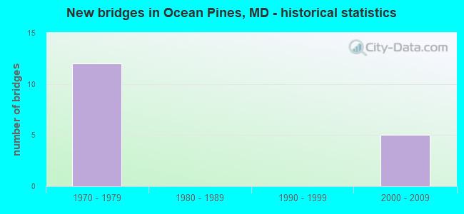
- New bridges - historical statistics
- 121970-1979
- 52000-2009

- Reconstructed bridges - Historical Statistics
- 12000-2009
- 12010-2019


- Bridge Condition - Deck
- 36.4%Good
- 54.5%Satisfactory
- 9.1%Fair

- Bridge Condition - Superstructure
- 36.4%Good
- 36.4%Satisfactory
- 27.3%Fair

- Bridge Condition - Substructure
- 27.3%Good
- 45.5%Satisfactory
- 27.3%Fair

- Bridge Condition - Channel
- 40.0%Very good
- 60.0%Good
Find on map >> Show street view
Structure Number: 10000023002001, Location: 2.8 MILES EAST OF MD 589 (Lat: 38.389369, Lng: -75.128264), Route carried "on" structure: State highway 90, Year Built: 1970, Status: Open, Structure Length: 125.88m (412.99ft), Average Daily Traffic: 18,062 (year 2009), Truck Traffic: 8%, Average Future Daily Traffic: 20,722 (year 2026), Design Load: HS 20, Features Intersected: ST MARTIN RIVER
Minimum Vertical Clearance: 30+ m (98+ ft), Kilometerpoint: 14.175, Lanes on structure: 2, Base Highway Network: Yes, Owner: State Highway Agency, Approaching Roadway Width: 14.3m (46.9ft), Navigation Control: Yes ( Vertical Clearance: 11.3m (37.1ft), Horizontal Clearance: 30.5m (100.1ft)), Material/Design: Prestressed concrete, Design/Construction: Stringer/Multi-beam, Number Of Spans In Main Unit: 3, Number Of Approach Spans: 66, Length of Maximum Span: 39.6m (129.9ft), Curb-To-Curb Width: 11.6m (38.1ft), Out-to-Out Width: 12.6m (41.3ft)
Condition: Deck: Satisfactory, Superstructure: Satisfactory, Substructure: Satisfactory, Channel: Good, Operating Rating: 45.8 metric tons, Method Used To Determine Operating Rating: Load Factor (LF), Inventory Rating: 27.2 metric tons, Method Used To Determine Inventory Rating: Load Factor (LF), Structural Evaluation: Equal to present minimum criteria, Deck Geometry: Somewhat better than minimum adequacy, Waterway Adequacy: Superior to present desirable criteria, Approach Roadway Alignment: Equal to present desirable criteria, Length Of Structure Improvement: 125.88m (412.99ft), Designated Inspection Frequency: Every 24 months, Underwater Inspection Frequency: Every 48 months, Inspection Date: October 2020, Underwater Inspection Date: September 2019, Bridge Improvement Cost: $10,284,000, Roadway Improvement Cost: $1,028,000, Total Project Cost: $11,312,000, Deck Structure Type: Concrete Cast-file-Place, Wearing Surface/Protective System: Wearing Surface: Bituminous, Membrane: Other
Find on map >> Show street view
Structure Number: 10000023002101, Location: 1.17 MILES WEST OF MD 528 (Lat: 38.390164, Lng: -75.100467), Route carried "on" structure: State highway 90, Year Built: 1971, Year Reconstructed: 2009, Status: Open, Structure Length: 231.04m (758.01ft), Average Daily Traffic: 18,062 (year 2015), Truck Traffic: 8%, Average Future Daily Traffic: 20,722 (year 2035), Design Load: HS 20, Features Intersected: ASSAWOMAN BAY
Minimum Vertical Clearance: 30+ m (98+ ft), Kilometerpoint: 17.152, Lanes on structure: 2, Base Highway Network: Yes, Owner: State Highway Agency, Approaching Roadway Width: 13.4m (44.0ft), Navigation Control: Yes ( Vertical Clearance: 11.3m (37.1ft), Horizontal Clearance: 30.5m (100.1ft)), Material/Design: Steel, Design/Construction: Stringer/Multi-beam, Number Of Spans In Main Unit: 3, Number Of Approach Spans: 136, Length of Maximum Span: 39.6m (129.9ft), Curb-To-Curb Width: 11.6m (38.1ft), Out-to-Out Width: 12.6m (41.3ft)
Condition: Deck: Satisfactory, Superstructure: Fair, Substructure: Satisfactory, Channel: Very good, Operating Rating: 34.9 metric tons, Method Used To Determine Operating Rating: Load Testing, Inventory Rating: 20.9 metric tons, Method Used To Determine Inventory Rating: Load Testing, Structural Evaluation: Somewhat better than minimum adequacy, Deck Geometry: Somewhat better than minimum adequacy, Waterway Adequacy: Superior to present desirable criteria, Approach Roadway Alignment: Equal to present desirable criteria, Length Of Structure Improvement: 231.04m (758.01ft), Designated Inspection Frequency: Every 24 months, Underwater Inspection Frequency: Every 48 months, Other Special Inspection Frequency: Every 12 months, Inspection Date: October 2020, Underwater Inspection Date: October 2019, Other Special Inspection Date: October 2021, Bridge Improvement Cost: $18,874,000, Roadway Improvement Cost: $1,887,000, Total Project Cost: $20,761,000, Deck Structure Type: Concrete Cast-file-Place, Wearing Surface/Protective System: Wearing Surface: Bituminous, Membrane: Other
Find on map >> Show street view
Structure Number: 10000023002204, Location: 1.77 MILE EAST OF MD 589 (Lat: 38.388569, Lng: -75.140131), Route carried "on" structure: State highway 90, Year Built: 1971, Status: Open, Structure Length: 1.22m (4.00ft), Average Daily Traffic: 18,062 (year 2009), Truck Traffic: 8%, Average Future Daily Traffic: 24,662 (year 2029), Design Load: HS 20, Features Intersected: OCEAN PKWY & GOLF PATH
Minimum Vertical Clearance: 30+ m (98+ ft), Kilometerpoint: 12.512, Lanes on structure: 2, Lanes under structure: 3, Base Highway Network: Yes, Owner: State Highway Agency, Approaching Roadway Width: 13.4m (44.0ft), Material/Design: Concrete continuous, Design/Construction: Frame, Number Of Spans In Main Unit: 3, Length of Maximum Span: 3.7m (12.1ft), Curb-To-Curb Width: 13.4m (44.0ft), Out-to-Out Width: 14.3m (46.9ft)
Condition: Deck: Fair, Superstructure: Fair, Substructure: Fair, Operating Rating: 32.7 metric tons, Method Used To Determine Operating Rating: Field evaluation and documented engineering judgment, Inventory Rating: 32.7 metric tons, Method Used To Determine Inventory Rating: Field evaluation and documented engineering judgment, Structural Evaluation: Somewhat better than minimum adequacy, Deck Geometry: Equal to present minimum criteria, Underclear: High priority of replacement, Approach Roadway Alignment: Equal to present desirable criteria, Length Of Structure Improvement: 1.22m (4.00ft), Designated Inspection Frequency: Every 24 months, Inspection Date: September 2021, Bridge Improvement Cost: $192,000, Roadway Improvement Cost: $19,000, Total Project Cost: $211,000, Deck Structure Type: Concrete Cast-file-Place, Wearing Surface/Protective System: Wearing Surface: Monolithic Concrete
Find on map >> Show street view
Structure Number: 10000023002601, Location: 1.58 MILES EAST OF MD 575 (Lat: 38.380369, Lng: -75.170969), Route carried "on" structure: State highway 90, Year Built: 1973, Status: Open, Structure Length: 6.49m (21.29ft), Average Daily Traffic: 18,062 (year 2009), Truck Traffic: 8%, Average Future Daily Traffic: 24,662 (year 2029), Design Load: HS 20, Features Intersected: MD 589
Minimum Vertical Clearance: 30+ m (98+ ft), Kilometerpoint: 9.670, Lanes on structure: 2, Lanes under structure: 2, Base Highway Network: Yes, Owner: State Highway Agency, Approaching Roadway Width: 13.4m (44.0ft), Skew: 3 degrees, Material/Design: Steel, Design/Construction: Stringer/Multi-beam, Number Of Spans In Main Unit: 1, Number Of Approach Spans: 2, Length of Maximum Span: 36.6m (120.1ft), Curb-To-Curb Width: 13.4m (44.0ft), Out-to-Out Width: 14.4m (47.2ft)
Condition: Deck: Satisfactory, Superstructure: Satisfactory, Substructure: Satisfactory, Inventory Rating: 56.2 metric tons, Method Used To Determine Inventory Rating: Load Factor (LF), Structural Evaluation: Equal to present minimum criteria, Deck Geometry: Equal to present minimum criteria, Underclear: Equal to present minimum criteria, Approach Roadway Alignment: Equal to present desirable criteria, Designated Inspection Frequency: Every 24 months, Inspection Date: April 2020, Deck Structure Type: Concrete Cast-file-Place, Wearing Surface/Protective System: Wearing Surface: Monolithic Concrete
Find on map >> Show street view
Structure Number: 10000023003101, Location: 0.4 MILE EAST OF US 113 (Lat: 38.377131, Lng: -75.199197), Route carried "on" structure: State highway 90, Year Built: 1976, Status: Open, Structure Length: 3.87m (12.70ft), Average Daily Traffic: 14,132 (year 2009), Truck Traffic: 8%, Average Future Daily Traffic: 16,271 (year 2026), Design Load: HS 20, Features Intersected: MD 575
Minimum Vertical Clearance: 30+ m (98+ ft), Kilometerpoint: 7.128, Lanes on structure: 2, Lanes under structure: 2, Base Highway Network: Yes, Owner: State Highway Agency, Approaching Roadway Width: 13.4m (44.0ft), Material/Design: Steel continuous, Design/Construction: Stringer/Multi-beam, Number Of Spans In Main Unit: 3, Length of Maximum Span: 16.8m (55.1ft), Curb-To-Curb Width: 13.4m (44.0ft), Out-to-Out Width: 14.4m (47.2ft)
Condition: Deck: Satisfactory, Superstructure: Satisfactory, Substructure: Satisfactory, Operating Rating: 58.5 metric tons, Method Used To Determine Operating Rating: Load Factor (LF), Inventory Rating: 34.9 metric tons, Method Used To Determine Inventory Rating: Load Factor (LF), Structural Evaluation: Equal to present minimum criteria, Deck Geometry: Equal to present minimum criteria, Underclear: Equal to present minimum criteria, Approach Roadway Alignment: Equal to present desirable criteria, Designated Inspection Frequency: Every 24 months, Inspection Date: October 2021, Deck Structure Type: Concrete Cast-file-Place, Wearing Surface/Protective System: Wearing Surface: Monolithic Concrete
Find on map >> Show street view
Structure Number: 10000023003201, Location: 0.4 MILE WEST OF MD 575 (Lat: 38.377119, Lng: -75.206792), Route carried "on" structure: State highway 90, Year Built: 1976, Status: Open, Structure Length: 7.77m (25.49ft), Average Daily Traffic: 14,132 (year 2009), Truck Traffic: 8%, Average Future Daily Traffic: 16,271 (year 2026), Design Load: HS 20, Features Intersected: US 113
Minimum Vertical Clearance: 30+ m (98+ ft), Kilometerpoint: 6.484, Lanes on structure: 3, Lanes under structure: 6, Base Highway Network: Yes, Owner: State Highway Agency, Approaching Roadway Width: 13.4m (44.0ft), Material/Design: Steel continuous, Design/Construction: Stringer/Multi-beam, Number Of Spans In Main Unit: 2, Number Of Approach Spans: 2, Length of Maximum Span: 27.4m (89.9ft), Curb-To-Curb Width: 17.1m (56.1ft), Out-to-Out Width: 18.0m (59.1ft)
Condition: Deck: Satisfactory, Superstructure: Satisfactory, Substructure: Fair, Operating Rating: 40.8 metric tons, Method Used To Determine Operating Rating: Load Factor (LF), Inventory Rating: 24.5 metric tons, Method Used To Determine Inventory Rating: Load Factor (LF), Structural Evaluation: Somewhat better than minimum adequacy, Deck Geometry: Superior to present desirable criteria, Underclear: Better than present minimum criteria, Approach Roadway Alignment: Equal to present desirable criteria, Designated Inspection Frequency: Every 24 months, Inspection Date: April 2020, Deck Structure Type: Concrete Cast-file-Place, Wearing Surface/Protective System: Wearing Surface: Monolithic Concrete
Find on map >> Show street view
Structure Number: 100000230042011, Location: 0.286 MILE N OF MD 575A (Lat: 38.390606, Lng: -75.203297), Route carried "on" structure: US 113, Year Built: 2001, Status: Open, Structure Length: 3.81m (12.50ft), Average Daily Traffic: 14,192 (year 2009), Truck Traffic: 14%, Average Future Daily Traffic: 8,360 (year 2026), Design Load: HS 25 or greater, Features Intersected: MD 589
Minimum Vertical Clearance: 30+ m (98+ ft), Kilometerpoint: 52.852, Lanes on structure: 2, Lanes under structure: 4, Base Highway Network: Yes, Owner: State Highway Agency, Approaching Roadway Width: 11.6m (38.1ft), Material/Design: Prestressed concrete, Design/Construction: Stringer/Multi-beam, Number Of Spans In Main Unit: 1, Length of Maximum Span: 36.6m (120.1ft), Curb-To-Curb Width: 11.6m (38.1ft), Out-to-Out Width: 12.8m (42.0ft)
Condition: Deck: Good, Superstructure: Good, Substructure: Good, Operating Rating: 73.0 metric tons, Method Used To Determine Operating Rating: Load Factor (LF), Inventory Rating: 43.5 metric tons, Method Used To Determine Inventory Rating: Load Factor (LF), Structural Evaluation: Better than present minimum criteria, Deck Geometry: Better than present minimum criteria, Underclear: Somewhat better than minimum adequacy, Approach Roadway Alignment: Equal to present desirable criteria, Designated Inspection Frequency: Every 24 months, Inspection Date: May 2020, Deck Structure Type: Concrete Cast-file-Place, Wearing Surface/Protective System: Wearing Surface: Monolithic Concrete, Deck Protection: Epoxy Coated Reinforcing
Find on map >> Show street view
Structure Number: 100000230042012, Location: 0.286 MILE N OF MD 575A (Lat: 38.390900, Lng: -75.203592), Route carried "on" structure: US 113, Year Built: 2001, Status: Open, Structure Length: 3.81m (12.50ft), Average Daily Traffic: 14,192 (year 2009), Truck Traffic: 14%, Average Future Daily Traffic: 8,360 (year 2026), Design Load: HS 25 or greater, Features Intersected: MD 589
Minimum Vertical Clearance: 30+ m (98+ ft), Kilometerpoint: 52.852, Lanes on structure: 2, Lanes under structure: 4, Base Highway Network: Yes, Owner: State Highway Agency, Approaching Roadway Width: 11.6m (38.1ft), Material/Design: Prestressed concrete, Design/Construction: Stringer/Multi-beam, Number Of Spans In Main Unit: 1, Length of Maximum Span: 36.6m (120.1ft), Curb-To-Curb Width: 11.6m (38.1ft), Out-to-Out Width: 12.8m (42.0ft)
Condition: Deck: Good, Superstructure: Good, Substructure: Good, Operating Rating: 73.0 metric tons, Method Used To Determine Operating Rating: Load Factor (LF), Inventory Rating: 43.5 metric tons, Method Used To Determine Inventory Rating: Load Factor (LF), Structural Evaluation: Better than present minimum criteria, Deck Geometry: Better than present minimum criteria, Underclear: Somewhat better than minimum adequacy, Approach Roadway Alignment: Equal to present desirable criteria, Designated Inspection Frequency: Every 24 months, Inspection Date: May 2020, Deck Structure Type: Concrete Cast-file-Place, Wearing Surface/Protective System: Wearing Surface: Monolithic Concrete, Deck Protection: Epoxy Coated Reinforcing
Find on map >> Show street view
Structure Number: 10000023004301, Location: 0.312 MILE N OF MD 589 (Lat: 38.394700, Lng: -75.204631), Route carried "on" structure: US 113, Year Built: 2001, Status: Open, Structure Length: 13.90m (45.60ft), Average Daily Traffic: 14,192 (year 2009), Truck Traffic: 14%, Average Future Daily Traffic: 16,721 (year 2026), Design Load: HS 25 or greater, Features Intersected: CHURCH BRANCH
Minimum Vertical Clearance: 30+ m (98+ ft), Kilometerpoint: 53.383, Lanes on structure: 5, Base Highway Network: Yes, Owner: State Highway Agency, Approaching Roadway Width: 27.4m (89.9ft), Skew: 32 degrees, Material/Design: Prestressed concrete continuous, Design/Construction: Stringer/Multi-beam, Number Of Spans In Main Unit: 4, Length of Maximum Span: 38.1m (125.0ft), Curb-To-Curb Width: 26.2m (86.0ft), Out-to-Out Width: 27.8m (91.2ft)
Condition: Deck: Good, Superstructure: Good, Substructure: Good, Channel: Very good, Operating Rating: 69.8 metric tons, Method Used To Determine Operating Rating: Load Factor (LF), Inventory Rating: 41.7 metric tons, Method Used To Determine Inventory Rating: Load Factor (LF), Structural Evaluation: Better than present minimum criteria, Deck Geometry: Superior to present desirable criteria, Waterway Adequacy: Superior to present desirable criteria, Approach Roadway Alignment: Equal to present desirable criteria, Designated Inspection Frequency: Every 24 months, Inspection Date: May 2020, Deck Structure Type: Concrete Cast-file-Place, Wearing Surface/Protective System: Wearing Surface: Monolithic Concrete, Deck Protection: Epoxy Coated Reinforcing
Find on map >> Show street view
Structure Number: 200000WOOP0201, Location: 1200' WEST OF OCEAN PKWY (Lat: 38.391578, Lng: -75.144561), Route carried "on" structure: County highway 496, Year Built: 1970, Year Reconstructed: 2017, Status: Open, Structure Length: 0.98m (3.22ft), Average Daily Traffic: 1,192 (year 2015), Truck Traffic: 5%, Average Future Daily Traffic: 1,455 (year 2035), Features Intersected: CANAL, Facility Carried by Structure: CLUBHOUSE DRIVE
Minimum Vertical Clearance: 30+ m (98+ ft), Kilometerpoint: 0.000, Lanes on structure: 2, Owner: County Highway Agency, Approaching Roadway Width: 7.3m (24.0ft), Material/Design: Concrete, Design/Construction: Channel Beam, Number Of Spans In Main Unit: 1, Length of Maximum Span: 8.2m (26.9ft), Curb or Sidewalk Widths: Left: 1.5m (4.9ft), Right: 1.5m (4.9ft), Curb-To-Curb Width: 7.5m (24.6ft), Out-to-Out Width: 11.0m (36.1ft)
Condition: Deck: Good, Superstructure: Good, Substructure: Fair, Channel: Good, Operating Rating: 71.7 metric tons, Method Used To Determine Operating Rating: Field evaluation and documented engineering judgment, Inventory Rating: 42.6 metric tons, Method Used To Determine Inventory Rating: Field evaluation and documented engineering judgment, Structural Evaluation: Somewhat better than minimum adequacy, Deck Geometry: Meets minimum limits, Waterway Adequacy: Better than present minimum criteria, Approach Roadway Alignment: Equal to present desirable criteria, Designated Inspection Frequency: Every 12 months, Underwater Inspection Frequency: Every 48 months, Inspection Date: September 2021, Underwater Inspection Date: September 2021, Deck Structure Type: Concrete Precast Panels, Wearing Surface/Protective System: Wearing Surface: Bituminous
Find on map >> Show street view
Structure Number: 200000WOOP0401, Location: 200' NORTH OF MD 589 (Lat: 38.384419, Lng: -75.176850), Route carried "on" structure: County highway 583, Year Built: 1970, Status: Posted for load, Structure Length: 3.35m (10.99ft), Average Daily Traffic: 5,660 (year 2016), Truck Traffic: 5%, Average Future Daily Traffic: 6,907 (year 2036), Design Load: H 10, Features Intersected: POND, Facility Carried by Structure: OCEAN PARKWAY SB
Minimum Vertical Clearance: 30+ m (98+ ft), Kilometerpoint: 0.000, Lanes on structure: 1, Owner: County Highway Agency, Approaching Roadway Width: 3.7m (12.1ft), Material/Design: Wood or Timber, Design/Construction: Slab, Number Of Spans In Main Unit: 11, Length of Maximum Span: 3.0m (9.8ft), Curb-To-Curb Width: 2.7m (8.9ft), Out-to-Out Width: 3.7m (12.1ft)
Condition: Deck: Satisfactory, Superstructure: Fair, Substructure: Satisfactory, Channel: Good, Operating Rating: 32.7 metric tons, Method Used To Determine Operating Rating: Field evaluation and documented engineering judgment, Inventory Rating: 32.7 metric tons, Method Used To Determine Inventory Rating: Field evaluation and documented engineering judgment, Structural Evaluation: Somewhat better than minimum adequacy, Deck Geometry: High priority of replacement, Waterway Adequacy: Better than present minimum criteria, Approach Roadway Alignment: Equal to present desirable criteria, Length Of Structure Improvement: 4.57m (14.99ft), Designated Inspection Frequency: Every 24 months, Inspection Date: September 2021, Deck Structure Type: Concrete Cast-file-Place, Wearing Surface/Protective System: Wearing Surface: Monolithic Concrete
Find on map >> Show street view
Structure Number: 10000023002204, Location: 1.76 MI E OF MD 589 (Lat: 38.388569, Lng: -75.140131), Route carried "under" structure: County highway 583, Year Built: 1971, Structure Length: 0. m, Average Daily Traffic: 2,000 (year 2012), Features Intersected: OCEAN PARKWAY, Facility Carried by Structure: MD 90
Minimum Vertical Clearance: 3.05m (10.01ft), Kilometerpoint: 4.666, Lanes on structure: 2, Lanes under structure: 2, Material/Design: Concrete continuous, Design/Construction: Frame, Length of Maximum Span: 0.0m
Find on map >> Show street view
Structure Number: 10000023002601, Location: 1.60 MILES E OF US 113 (Lat: 38.380369, Lng: -75.170969), Route carried "under" structure: State highway 589, Year Built: 1973, Structure Length: 0. m, Average Daily Traffic: 9,321 (year 2009), Features Intersected: MD 589, Facility Carried by Structure: MD 90
Minimum Vertical Clearance: 4.88m (16.01ft), Kilometerpoint: 4.232, Lanes on structure: 2, Lanes under structure: 4, Material/Design: Steel, Design/Construction: Stringer/Multi-beam, Length of Maximum Span: 36.6m (120.1ft)
Find on map >> Show street view
Structure Number: 10000023003101, Location: 1.7 MILES EAST OF US 113 (Lat: 38.377131, Lng: -75.199197), Route carried "under" structure: State highway 575, Year Built: 1976, Structure Length: 0. m, Average Daily Traffic: 1,212 (year 2009), Features Intersected: MD 575, Facility Carried by Structure: MD 90
Minimum Vertical Clearance: 4.88m (16.01ft), Kilometerpoint: 2.735, Lanes on structure: 2, Lanes under structure: 2, Material/Design: Steel continuous, Design/Construction: Stringer/Multi-beam, Length of Maximum Span: 16.8m (55.1ft)
Find on map >> Show street view
Structure Number: 10000023003201, Location: 0.98 MILE SOUTH OF MD 589 (Lat: 38.377119, Lng: -75.206792), Route carried "under" structure: US 113, Year Built: 1976, Structure Length: 0. m, Average Daily Traffic: 9,692 (year 2009), Truck Traffic: 8%, Features Intersected: US 113, Facility Carried by Structure: MD 90
Minimum Vertical Clearance: 4.88m (16.01ft), Kilometerpoint: 51.295, Lanes on structure: 3, Lanes under structure: 6, Material/Design: Steel continuous, Design/Construction: Stringer/Multi-beam, Length of Maximum Span: 27.4m (89.9ft)
Find on map >> Show street view
Structure Number: 100000230042011, Location: 0.004 MILE S OF MD 575A (Lat: 38.390606, Lng: -75.203297), Route carried "under" structure: State highway 589, Year Built: 2001, Structure Length: 0. m, Average Daily Traffic: 9,321 (year 2009), Truck Traffic: 14%, Features Intersected: MD 589, Facility Carried by Structure: US 113 NBR
Minimum Vertical Clearance: 5.18m (16.99ft), Kilometerpoint: 7.411, Lanes on structure: 2, Lanes under structure: 4, Material/Design: Prestressed concrete, Design/Construction: Stringer/Multi-beam, Length of Maximum Span: 36.6m (120.1ft)
Find on map >> Show street view
Structure Number: 100000230042012, Location: 0.004 MILE S OF MD 575A (Lat: 38.390900, Lng: -75.203592), Route carried "under" structure: State highway 589, Year Built: 2001, Structure Length: 0. m, Average Daily Traffic: 9,321 (year 2009), Truck Traffic: 14%, Features Intersected: MD 589, Facility Carried by Structure: US 113 SBR
Minimum Vertical Clearance: 5.18m (16.99ft), Kilometerpoint: 7.411, Lanes on structure: 2, Lanes under structure: 4, Material/Design: Prestressed concrete, Design/Construction: Stringer/Multi-beam, Length of Maximum Span: 36.6m (120.1ft)