Bridge Statistics for Palatine, Illinois (IL)
Condition, Traffic, Stress, Structural Evaluation, Project Costs
- National Bridge Inventory (NBI) Statistics
- 23Number of bridges
- 335ft / 102mTotal length
- $7,319,000Total costs
- 579,300Total average daily traffic
- 29,603Total average daily truck traffic
- National Bridge Inventory (NBI) Registered Bridges for Palatine
- No street view available for this location
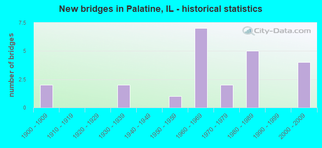
- New bridges - historical statistics
- 21900-1909
- 21930-1939
- 11950-1959
- 71960-1969
- 21970-1979
- 51980-1989
- 42000-2009

- Reconstructed bridges - Historical Statistics
- 11950-1959
- 11960-1969
- 01970-1979
- 01980-1989
- 01990-1999
- 12000-2009


- Bridge Condition - Deck
- 11.1%Very good
- 33.3%Good
- 11.1%Satisfactory
- 11.1%Fair
- 22.2%Poor
- 11.1%Serious

- Bridge Condition - Superstructure
- 20.0%Very good
- 40.0%Good
- 20.0%Satisfactory
- 10.0%Fair
- 10.0%Serious

- Bridge Condition - Substructure
- 20.0%Very good
- 40.0%Good
- 30.0%Satisfactory
- 10.0%Poor

- Bridge Condition - Channel
- 7.1%Very good
- 42.9%Good
- 50.0%Satisfactory

- Bridge Condition - Culverts
- 11.1%Very good
- 44.4%Good
- 33.3%Satisfactory
- 11.1%Serious
Find on map >> Show street view
Structure Number: 160374, Location: 1 M S PALATINE RD (Lat: 42.100469, Lng: -88.019972), Route carried "on" structure: State highway 53, Year Built: 1964, Status: Open, Structure Length: 15.71m (51.54ft), Average Daily Traffic: 103,600 (year 2021), Truck Traffic: 5%, Average Future Daily Traffic: 84,666 (year 2032), Design Load: HS 20, Features Intersected: US 14 NW HWY & UP RR
Minimum Vertical Clearance: 30+ m (98+ ft), Kilometerpoint: 116.739, Lanes on structure: 3, Lanes under structure: 4, Base Highway Network: Yes, Owner: State Highway Agency, Approaching Roadway Width: 11.3m (37.1ft), Skew: 2 degrees, Material/Design: Steel continuous, Design/Construction: Stringer/Multi-beam, Number Of Spans In Main Unit: 7, Length of Maximum Span: 25.6m (84.0ft), Curb-To-Curb Width: 11.0m (36.1ft), Out-to-Out Width: 17.7m (58.1ft)
Condition: Deck: Poor, Superstructure: Satisfactory, Substructure: Good, Operating Rating: 49.2 metric tons, Method Used To Determine Operating Rating: Load Factor (LF) rating reported by rating factor (RF) method using MS18 loading, Inventory Rating: 29.5 metric tons, Method Used To Determine Inventory Rating: Load Factor (LF) rating reported by rating factor (RF) method using MS18 loading, Structural Evaluation: Equal to present minimum criteria, Deck Geometry: High priority of replacement, Underclear: Equal to present minimum criteria, Approach Roadway Alignment: Equal to present desirable criteria, Length Of Structure Improvement: 16.49m (54.10ft), Designated Inspection Frequency: Every 24 months, Inspection Date: October 2020, Bridge Improvement Cost: $4,604,000, Roadway Improvement Cost: $460,000, Total Project Cost: $6,906,000, Deck Structure Type: Concrete Cast-file-Place, Wearing Surface/Protective System: Wearing Surface: Other
Find on map >> Show street view
Structure Number: 161119, Location: 2.5 M S US 12 (Lat: 42.100550, Lng: -88.019789), Route carried "on" structure: State highway 53, Year Built: 1964, Status: Open, Structure Length: 15.83m (51.94ft), Average Daily Traffic: 103,600 (year 2021), Truck Traffic: 5%, Average Future Daily Traffic: 84,666 (year 2032), Design Load: HS 20, Features Intersected: US 14&UPRR FAU3512
Minimum Vertical Clearance: 30+ m (98+ ft), Kilometerpoint: 116.755, Lanes on structure: 3, Lanes under structure: 4, Base Highway Network: Yes, Owner: State Highway Agency, Approaching Roadway Width: 18.9m (62.0ft), Skew: 2 degrees, Material/Design: Steel continuous, Design/Construction: Stringer/Multi-beam, Number Of Spans In Main Unit: 7, Length of Maximum Span: 25.2m (82.7ft), Curb-To-Curb Width: 18.9m (62.0ft), Out-to-Out Width: 19.9m (65.3ft)
Condition: Deck: Poor, Superstructure: Satisfactory, Substructure: Good, Operating Rating: 59.6 metric tons, Method Used To Determine Operating Rating: Load Factor (LF) rating reported by rating factor (RF) method using MS18 loading, Inventory Rating: 31.8 metric tons, Method Used To Determine Inventory Rating: Load Factor (LF) rating reported by rating factor (RF) method using MS18 loading, Structural Evaluation: Equal to present minimum criteria, Deck Geometry: Superior to present desirable criteria, Underclear: High priority of corrective action, Approach Roadway Alignment: Equal to present desirable criteria, Designated Inspection Frequency: Every 24 months, Inspection Date: October 2020, Deck Structure Type: Concrete Cast-file-Place, Wearing Surface/Protective System: Wearing Surface: Other
Find on map >> Show street view
Structure Number: 162008, Location: 1.1 M S IL 68 (Lat: 42.122089, Lng: -88.033894), Route carried "on" structure: Other road , Year Built: 1900, Year Reconstructed: 1974, Status: Open, Structure Length: 1.22m (4.00ft), Average Daily Traffic: 12,300 (year 2021), Truck Traffic: 2%, Average Future Daily Traffic: 21,012 (year 2032), Features Intersected: SALT CREEK, Facility Carried by Structure: HICKS RD
Minimum Vertical Clearance: 30+ m (98+ ft), Kilometerpoint: 3.621, Lanes on structure: 4, Base Highway Network: Yes, Owner: State Highway Agency, Approaching Roadway Width: 20.7m (67.9ft), Skew: 22 degrees, Material/Design: Concrete continuous, Design/Construction: Culvert, Number Of Spans In Main Unit: 3, Length of Maximum Span: 3.7m (12.1ft), Curb or Sidewalk Widths: Left: 0.0m, Right: 1.5m (4.9ft)
Condition: Channel: Good, Culverts: Good, Operating Rating: 54.1 metric tons, Method Used To Determine Operating Rating: Field evaluation and documented engineering judgment, Inventory Rating: 32.4 metric tons, Method Used To Determine Inventory Rating: Field evaluation and documented engineering judgment, Structural Evaluation: Better than present minimum criteria, Waterway Adequacy: Equal to present desirable criteria, Approach Roadway Alignment: Equal to present desirable criteria, Designated Inspection Frequency: Every 24 months, Inspection Date: July 2020
Find on map >> Show street view
Structure Number: 162416, Location: 0.3 M E QUENTIN RD (Lat: 42.110358, Lng: -88.055406), Route carried "on" structure: Other road , Year Built: 1930, Status: Open, Structure Length: 0.73m (2.40ft), Average Daily Traffic: 12,400 (year 2018), Truck Traffic: 7%, Average Future Daily Traffic: 11,639 (year 2032), Features Intersected: SALT CREEK, Facility Carried by Structure: PALATINE RD
Minimum Vertical Clearance: 30+ m (98+ ft), Kilometerpoint: 9.559, Lanes on structure: 2, Base Highway Network: Yes, Owner: State Highway Agency, Approaching Roadway Width: 7.9m (25.9ft), Skew: 3 degrees, Material/Design: Concrete continuous, Design/Construction: Culvert, Number Of Spans In Main Unit: 2, Length of Maximum Span: 3.4m (11.2ft), Curb or Sidewalk Widths: Left: 0.0m, Right: 1.8m (5.9ft), Out-to-Out Width: 26.8m (87.9ft)
Condition: Channel: Satisfactory, Culverts: Satisfactory, Operating Rating: 54.1 metric tons, Method Used To Determine Operating Rating: Field evaluation and documented engineering judgment, Inventory Rating: 32.4 metric tons, Method Used To Determine Inventory Rating: Field evaluation and documented engineering judgment, Structural Evaluation: Equal to present minimum criteria, Waterway Adequacy: Equal to present desirable criteria, Approach Roadway Alignment: Equal to present desirable criteria, Designated Inspection Frequency: Every 24 months, Inspection Date: March 2021
Find on map >> Show street view
Structure Number: 162466, Location: .82 S OF LAKE COOK R (Lat: 42.142803, Lng: -88.033817), Route carried "on" structure: Other road , Year Built: 1932, Year Reconstructed: 1964, Status: Open, Structure Length: 0.88m (2.89ft), Average Daily Traffic: 15,700 (year 2021), Truck Traffic: 4%, Average Future Daily Traffic: 18,540 (year 2032), Features Intersected: BUFFALO CREEK TRIB, Facility Carried by Structure: HICKS RD
Minimum Vertical Clearance: 30+ m (98+ ft), Kilometerpoint: 1.320, Lanes on structure: 4, Base Highway Network: Yes, Owner: State Highway Agency, Approaching Roadway Width: 14.6m (47.9ft), Skew: 25 degrees, Material/Design: Concrete continuous, Design/Construction: Culvert, Number Of Spans In Main Unit: 2, Length of Maximum Span: 4.1m (13.5ft)
Condition: Channel: Satisfactory, Culverts: Satisfactory, Operating Rating: 35.0 metric tons, Method Used To Determine Operating Rating: Load Factor (LF) rating reported by rating factor (RF) method using MS18 loading, Inventory Rating: 20.7 metric tons, Method Used To Determine Inventory Rating: Load Factor (LF) rating reported by rating factor (RF) method using MS18 loading, Structural Evaluation: Somewhat better than minimum adequacy, Waterway Adequacy: Equal to present desirable criteria, Approach Roadway Alignment: Equal to present desirable criteria, Designated Inspection Frequency: Every 24 months, Inspection Date: January 2021
Find on map >> Show street view
Structure Number: 162518, Location: 0.2 MI. NW OF IL 68 (Lat: 42.142139, Lng: -88.025069), Route carried "on" structure: US 12, Year Built: 1984, Status: Open, Structure Length: 0.76m (2.49ft), Average Daily Traffic: 18,500 (year 2019), Truck Traffic: 5%, Average Future Daily Traffic: 31,209 (year 2032), Design Load: HS 20, Features Intersected: BUFFALO CREEK
Minimum Vertical Clearance: 30+ m (98+ ft), Kilometerpoint: 52.801, Lanes on structure: 4, Base Highway Network: Yes, Owner: State Highway Agency, Approaching Roadway Width: 18.3m (60.0ft), Material/Design: Concrete continuous, Design/Construction: Culvert, Number Of Spans In Main Unit: 2, Length of Maximum Span: 3.7m (12.1ft)
Condition: Channel: Good, Culverts: Very good, Operating Rating: 56.7 metric tons, Method Used To Determine Operating Rating: Load Factor (LF) rating reported by rating factor (RF) method using MS18 loading, Inventory Rating: 34.3 metric tons, Method Used To Determine Inventory Rating: Load Factor (LF) rating reported by rating factor (RF) method using MS18 loading, Structural Evaluation: Equal to present desirable criteria, Waterway Adequacy: Equal to present desirable criteria, Approach Roadway Alignment: Equal to present desirable criteria, Designated Inspection Frequency: Every 48 months, Inspection Date: August 2018
Find on map >> Show street view
Structure Number: 162653, Location: 0.01 W WINSTON DR (Lat: 42.110169, Lng: -88.016908), Route carried "on" structure: Other road , Year Built: 1959, Status: Posted for load, Structure Length: 0.67m (2.20ft), Average Daily Traffic: 15,700 (year 2021), Truck Traffic: 3%, Average Future Daily Traffic: 20,394 (year 2032), Features Intersected: SALT CREEK, Facility Carried by Structure: PALATINE RD
Minimum Vertical Clearance: 30+ m (98+ ft), Kilometerpoint: 11.523, Lanes on structure: 8, Base Highway Network: Yes, Owner: State Highway Agency, Approaching Roadway Width: 34.7m (113.8ft), Skew: 30 degrees, Material/Design: Concrete continuous, Design/Construction: Culvert, Number Of Spans In Main Unit: 2, Length of Maximum Span: 3.0m (9.8ft), Curb or Sidewalk Widths: Left: 1.5m (4.9ft), Right: 1.5m (4.9ft), Curb-To-Curb Width: 34.7m (113.8ft), Out-to-Out Width: 40.8m (133.9ft)
Condition: Channel: Good, Culverts: Satisfactory, Operating Rating: 19.4 metric tons, Method Used To Determine Operating Rating: Load Factor (LF) rating reported by rating factor (RF) method using MS18 loading, Inventory Rating: 11.7 metric tons, Method Used To Determine Inventory Rating: Load Factor (LF) rating reported by rating factor (RF) method using MS18 loading, Structural Evaluation: High priority of corrective action, Deck Geometry: Better than present minimum criteria, Waterway Adequacy: Equal to present desirable criteria, Approach Roadway Alignment: Better than present minimum criteria, Bridge Posting: Required (Relationship of Operating Rating to Maximum Legal Load: > 39.9% below), Length Of Structure Improvement: 0.67m (2.20ft), Designated Inspection Frequency: Every 12 months, Inspection Date: March 2021, Bridge Improvement Cost: $212,000, Roadway Improvement Cost: $21,000, Total Project Cost: $318,000
Find on map >> Show street view
Structure Number: 162732, Location: 0.1 M W US 14 (Lat: 42.133431, Lng: -88.094739), Route carried "on" structure: State highway 68, Year Built: 2008, Status: Open, Structure Length: 3.88m (12.73ft), Average Daily Traffic: 14,300 (year 2021), Truck Traffic: 6%, Average Future Daily Traffic: 18,849 (year 2032), Design Load: H 20, Features Intersected: RR - UP
Minimum Vertical Clearance: 30+ m (98+ ft), Kilometerpoint: 15.691, Lanes on structure: 4, Base Highway Network: Yes, Owner: State Highway Agency, Approaching Roadway Width: 22.8m (74.8ft), Skew: 23 degrees, Material/Design: Steel, Design/Construction: Stringer/Multi-beam, Number Of Spans In Main Unit: 1, Length of Maximum Span: 36.3m (119.1ft), Curb-To-Curb Width: 19.4m (63.6ft), Out-to-Out Width: 27.2m (89.2ft)
Condition: Deck: Very good, Superstructure: Very good, Substructure: Very good, Operating Rating: 70.3 metric tons, Method Used To Determine Operating Rating: Load Factor (LF) rating reported by rating factor (RF) method using MS18 loading, Inventory Rating: 42.1 metric tons, Method Used To Determine Inventory Rating: Load Factor (LF) rating reported by rating factor (RF) method using MS18 loading, Structural Evaluation: Equal to present desirable criteria, Deck Geometry: Better than present minimum criteria, Underclear: Better than present minimum criteria, Approach Roadway Alignment: Better than present minimum criteria, Designated Inspection Frequency: Every 24 months, Inspection Date: March 2020, Deck Structure Type: Concrete Cast-file-Place, Wearing Surface/Protective System: Deck Protection: Epoxy Coated Reinforcing
Find on map >> Show street view
Structure Number: 162861, Location: 3 M W OF IL 53 (Lat: 42.133694, Lng: -88.093831), Route carried "on" structure: State highway 68, Year Built: 2008, Status: Open, Structure Length: 4.08m (13.39ft), Average Daily Traffic: 14,300 (year 2021), Truck Traffic: 6%, Average Future Daily Traffic: 18,849 (year 2032), Features Intersected: US 14 (NW HWY)
Minimum Vertical Clearance: 30+ m (98+ ft), Kilometerpoint: 15.771, Lanes on structure: 4, Lanes under structure: 4, Base Highway Network: Yes, Owner: State Highway Agency, Approaching Roadway Width: 27.5m (90.2ft), Skew: 23 degrees, Material/Design: Steel, Design/Construction: Stringer/Multi-beam, Number Of Spans In Main Unit: 1, Length of Maximum Span: 39.2m (128.6ft), Curb-To-Curb Width: 27.5m (90.2ft), Out-to-Out Width: 29.0m (95.1ft)
Condition: Deck: Good, Superstructure: Very good, Substructure: Very good, Operating Rating: 72.3 metric tons, Method Used To Determine Operating Rating: Load Factor (LF) rating reported by rating factor (RF) method using MS18 loading, Inventory Rating: 43.4 metric tons, Method Used To Determine Inventory Rating: Load Factor (LF) rating reported by rating factor (RF) method using MS18 loading, Structural Evaluation: Equal to present desirable criteria, Deck Geometry: Superior to present desirable criteria, Underclear: High priority of corrective action, Approach Roadway Alignment: Better than present minimum criteria, Designated Inspection Frequency: Every 24 months, Inspection Date: March 2020, Deck Structure Type: Concrete Cast-file-Place, Wearing Surface/Protective System: Deck Protection: Epoxy Coated Reinforcing
Find on map >> Show street view
Structure Number: 163011, Location: 0.2 M N DUNDEE P18 (Lat: 42.140114, Lng: -88.062936), Route carried "on" structure: Other road , Year Built: 1900, Status: Posted for load, Structure Length: 0.73m (2.40ft), Average Daily Traffic: 20,200 (year 2018), Truck Traffic: 3%, Average Future Daily Traffic: 23,690 (year 2032), Features Intersected: BR OF SALT CREEK, Facility Carried by Structure: QUENTIN RD
Minimum Vertical Clearance: 30+ m (98+ ft), Kilometerpoint: 1.497, Lanes on structure: 2, Base Highway Network: Yes, Owner: County Highway Agency, Approaching Roadway Width: 7.3m (24.0ft), Material/Design: Concrete, Design/Construction: Slab, Number Of Spans In Main Unit: 1, Length of Maximum Span: 6.7m (22.0ft), Curb-To-Curb Width: 8.9m (29.2ft), Out-to-Out Width: 9.1m (29.9ft)
Condition: Deck: Serious, Superstructure: Serious, Substructure: Poor, Channel: Good, Operating Rating: 24.3 metric tons, Method Used To Determine Operating Rating: Load Factor (LF) rating reported by rating factor (RF) method using MS18 loading, Inventory Rating: 14.6 metric tons, Method Used To Determine Inventory Rating: Load Factor (LF) rating reported by rating factor (RF) method using MS18 loading, Structural Evaluation: High priority of replacement, Deck Geometry: High priority of replacement, Waterway Adequacy: Better than present minimum criteria, Approach Roadway Alignment: Equal to present desirable criteria, Bridge Posting: Required (Relationship of Operating Rating to Maximum Legal Load: 10.0 - 19.9% below), Length Of Structure Improvement: 1.31m (4.30ft), Designated Inspection Frequency: Every 24 months, Inspection Date: September 2021, Bridge Improvement Cost: $63,000, Roadway Improvement Cost: $6,000, Total Project Cost: $95,000, Deck Structure Type: Concrete Cast-file-Place, Wearing Surface/Protective System: Wearing Surface: Bituminous
Find on map >> Show street view
Structure Number: 163205, Location: .5 M. E. OF RAND RD. (Lat: 42.153706, Lng: -88.034036), Route carried "on" structure: Other road , Year Built: 1981, Status: Open, Structure Length: 40.15m (131.73ft), Average Daily Traffic: 43,600 (year 2018), Truck Traffic: 7%, Average Future Daily Traffic: 37,698 (year 2032), Design Load: HS 20, Features Intersected: SLOUGH E. OF RAND RD, Facility Carried by Structure: LAKE COOK ROAD
Minimum Vertical Clearance: 30+ m (98+ ft), Kilometerpoint: 0.370, Lanes on structure: 4, Base Highway Network: Yes, Owner: County Highway Agency, Approaching Roadway Width: 20.7m (67.9ft), Skew: 30 degrees, Material/Design: Prestressed concrete, Design/Construction: Stringer/Multi-beam, Number Of Spans In Main Unit: 18, Number Of Approach Spans: 2, Length of Maximum Span: 22.3m (73.2ft), Curb or Sidewalk Widths: Left: 1.5m (4.9ft), Right: 1.5m (4.9ft), Curb-To-Curb Width: 16.2m (53.1ft), Out-to-Out Width: 20.7m (67.9ft)
Condition: Deck: Fair, Superstructure: Fair, Substructure: Satisfactory, Channel: Very good, Operating Rating: 60.6 metric tons, Method Used To Determine Operating Rating: Load Factor (LF) rating reported by rating factor (RF) method using MS18 loading, Inventory Rating: 36.3 metric tons, Method Used To Determine Inventory Rating: Load Factor (LF) rating reported by rating factor (RF) method using MS18 loading, Structural Evaluation: Somewhat better than minimum adequacy, Deck Geometry: Meets minimum limits, Waterway Adequacy: Superior to present desirable criteria, Approach Roadway Alignment: Equal to present desirable criteria, Designated Inspection Frequency: Every 24 months, Underwater Inspection Frequency: Every 60 months, Inspection Date: August 2021, Underwater Inspection Date: August 2020, Deck Structure Type: Concrete Cast-file-Place, Wearing Surface/Protective System: Wearing Surface: Latex Concrete
Find on map >> Show street view
Structure Number: 163215, Location: 0.5 M E OF HICKS RD (Lat: 42.153642, Lng: -88.017547), Route carried "on" structure: Other road , Year Built: 1989, Status: Open, Structure Length: 10.37m (34.02ft), Average Daily Traffic: 49,900 (year 2018), Truck Traffic: 6%, Average Future Daily Traffic: 47,792 (year 2032), Design Load: HS 20, Features Intersected: IL 53, Facility Carried by Structure: LAKE COOK RD
Minimum Vertical Clearance: 30+ m (98+ ft), Kilometerpoint: 1.690, Lanes on structure: 4, Lanes under structure: 3, Base Highway Network: Yes, Owner: State Highway Agency, Approaching Roadway Width: 23.2m (76.1ft), Skew: 33 degrees, Material/Design: Steel continuous, Design/Construction: Stringer/Multi-beam, Number Of Spans In Main Unit: 2, Number Of Approach Spans: 2, Length of Maximum Span: 42.1m (138.1ft), Curb-To-Curb Width: 18.9m (62.0ft), Out-to-Out Width: 21.8m (71.5ft)
Condition: Deck: Satisfactory, Superstructure: Good, Substructure: Satisfactory, Operating Rating: 63.8 metric tons, Method Used To Determine Operating Rating: Load Factor (LF) rating reported by rating factor (RF) method using MS18 loading, Inventory Rating: 37.9 metric tons, Method Used To Determine Inventory Rating: Load Factor (LF) rating reported by rating factor (RF) method using MS18 loading, Structural Evaluation: Equal to present minimum criteria, Deck Geometry: Equal to present minimum criteria, Underclear: Somewhat better than minimum adequacy, Approach Roadway Alignment: Equal to present desirable criteria, Designated Inspection Frequency: Every 24 months, Other Special Inspection Frequency: Every 72 months, Inspection Date: October 2021, Other Special Inspection Date: August 2019, Deck Structure Type: Concrete Cast-file-Place, Wearing Surface/Protective System: Deck Protection: Epoxy Coated Reinforcing
Find on map >> Show street view
Structure Number: 163223, Location: 1.8 MI.S DUNDEE RD. (Lat: 42.110378, Lng: -88.062911), Route carried "on" structure: Other road , Year Built: 1985, Status: Open, Structure Length: 1.56m (5.12ft), Average Daily Traffic: 12,400 (year 2018), Truck Traffic: 7%, Average Future Daily Traffic: 11,639 (year 2032), Design Load: HS 20, Features Intersected: Salt Creek, Facility Carried by Structure: QUENTIN RDPALATNE
Minimum Vertical Clearance: 30+ m (98+ ft), Kilometerpoint: 8.948, Lanes on structure: 4, Base Highway Network: Yes, Owner: County Highway Agency, Approaching Roadway Width: 19.5m (64.0ft), Skew: 23 degrees, Material/Design: Concrete, Design/Construction: Culvert, Number Of Spans In Main Unit: 3, Length of Maximum Span: 2.7m (8.9ft)
Condition: Channel: Satisfactory, Culverts: Good, Operating Rating: 54.1 metric tons, Method Used To Determine Operating Rating: Field evaluation and documented engineering judgment, Inventory Rating: 32.4 metric tons, Method Used To Determine Inventory Rating: Field evaluation and documented engineering judgment, Structural Evaluation: Better than present minimum criteria, Waterway Adequacy: Equal to present desirable criteria, Approach Roadway Alignment: Equal to present desirable criteria, Designated Inspection Frequency: Every 48 months, Inspection Date: October 2019, Deck Structure Type: Other
Find on map >> Show street view
Structure Number: 163252, Location: 0.4M.W.OF PLUM GR.RD (Lat: 42.088631, Lng: -88.052417), Route carried "on" structure: Other road , Year Built: 1973, Status: Open, Structure Length: 0.70m (2.30ft), Average Daily Traffic: 20,600 (year 2018), Truck Traffic: 4%, Average Future Daily Traffic: 28,222 (year 2032), Design Load: HS 20, Features Intersected: SALT CREEK, Facility Carried by Structure: EUCLID AVE.
Minimum Vertical Clearance: 30+ m (98+ ft), Kilometerpoint: 0.901, Lanes on structure: 4, Base Highway Network: Yes, Owner: County Highway Agency, Approaching Roadway Width: 16.8m (55.1ft), Skew: 20 degrees, Material/Design: Concrete continuous, Design/Construction: Culvert, Number Of Spans In Main Unit: 2, Length of Maximum Span: 3.4m (11.2ft), Curb or Sidewalk Widths: Left: 1.8m (5.9ft), Right: 1.8m (5.9ft)
Condition: Channel: Satisfactory, Culverts: Good, Operating Rating: 59.6 metric tons, Method Used To Determine Operating Rating: Load Factor (LF) rating reported by rating factor (RF) method using MS18 loading, Inventory Rating: 35.6 metric tons, Method Used To Determine Inventory Rating: Load Factor (LF) rating reported by rating factor (RF) method using MS18 loading, Structural Evaluation: Better than present minimum criteria, Waterway Adequacy: Equal to present desirable criteria, Approach Roadway Alignment: Equal to present desirable criteria, Designated Inspection Frequency: Every 24 months, Inspection Date: April 2021
Find on map >> Show street view
Structure Number: 166667, Location: 420' W OF BOTHWELL (Lat: 42.103567, Lng: -88.046525), Route carried "on" structure: City street , Year Built: 1966, Status: Open, Structure Length: 0.84m (2.76ft), Average Daily Traffic: 175 (year 2018), Truck Traffic: 13%, Average Future Daily Traffic: 515 (year 2032), Features Intersected: SALT CREEK, Facility Carried by Structure: W. IMPERIAL CT.
Minimum Vertical Clearance: 30+ m (98+ ft), Kilometerpoint: 0.193, Lanes on structure: 2, Owner: City or Municipal Highway Agency, Approaching Roadway Width: 7.7m (25.3ft), Skew: 2 degrees, Material/Design: Concrete, Design/Construction: Culvert, Number Of Spans In Main Unit: 1, Length of Maximum Span: 0.0m, Curb or Sidewalk Widths: Left: 1.5m (4.9ft), Right: 1.3m (4.3ft), Curb-To-Curb Width: 7.7m (25.3ft)
Condition: Channel: Satisfactory, Culverts: Good, Operating Rating: 40.5 metric tons, Method Used To Determine Operating Rating: Field evaluation and documented engineering judgment, Inventory Rating: 24.3 metric tons, Method Used To Determine Inventory Rating: Field evaluation and documented engineering judgment, Structural Evaluation: Equal to present minimum criteria, Deck Geometry: Somewhat better than minimum adequacy, Waterway Adequacy: Equal to present desirable criteria, Approach Roadway Alignment: Equal to present desirable criteria, Designated Inspection Frequency: Every 24 months, Inspection Date: November 2021, Deck Structure Type: Other
Find on map >> Show street view
Structure Number: 167717, Location: 0.18 M E HICKS RDP18 (Lat: 42.122506, Lng: -88.030092), Route carried "on" structure: City street , Year Built: 1968, Year Reconstructed: 2005, Status: Open, Structure Length: 0.88m (2.89ft), Average Daily Traffic: 450 (year 2018), Truck Traffic: 10%, Average Future Daily Traffic: 524 (year 2032), Features Intersected: E BR SALT CR, Facility Carried by Structure: WILLOW WOOD DR
Minimum Vertical Clearance: 30+ m (98+ ft), Kilometerpoint: 0.193, Lanes on structure: 2, Owner: City or Municipal Highway Agency, Approaching Roadway Width: 7.9m (25.9ft), Skew: 3 degrees, Material/Design: Prestressed concrete, Design/Construction: Box Beam or Girders - Multiple, Number Of Spans In Main Unit: 1, Length of Maximum Span: 8.2m (26.9ft), Curb or Sidewalk Widths: Left: 2.2m (7.2ft), Right: 2.2m (7.2ft), Curb-To-Curb Width: 7.3m (24.0ft), Out-to-Out Width: 12.3m (40.4ft)
Condition: Deck: Good, Superstructure: Good, Substructure: Satisfactory, Channel: Good, Operating Rating: 97.2 metric tons, Method Used To Determine Operating Rating: Load Factor (LF) rating reported by rating factor (RF) method using MS18 loading, Inventory Rating: 59.0 metric tons, Method Used To Determine Inventory Rating: Load Factor (LF) rating reported by rating factor (RF) method using MS18 loading, Structural Evaluation: Equal to present minimum criteria, Deck Geometry: Meets minimum limits, Waterway Adequacy: Equal to present desirable criteria, Approach Roadway Alignment: Equal to present desirable criteria, Designated Inspection Frequency: Every 24 months, Inspection Date: January 2021, Deck Structure Type: Concrete Cast-file-Place, Wearing Surface/Protective System: Wearing Surface: Integral Concrete, Deck Protection: Epoxy Coated Reinforcing
Find on map >> Show street view
Structure Number: 167718, Location: 0.2 M S PALTN RD P18 (Lat: 42.107100, Lng: -88.012214), Route carried "on" structure: City street , Year Built: 1968, Status: Open, Structure Length: 0.76m (2.49ft), Average Daily Traffic: 175 (year 2018), Truck Traffic: 8%, Average Future Daily Traffic: 215 (year 2032), Features Intersected: SALT CR E BR, Facility Carried by Structure: KENILWORTH AVE
Minimum Vertical Clearance: 30+ m (98+ ft), Kilometerpoint: 0.193, Lanes on structure: 2, Owner: City or Municipal Highway Agency, Approaching Roadway Width: 8.1m (26.6ft), Material/Design: Concrete, Design/Construction: Frame, Number Of Spans In Main Unit: 1, Length of Maximum Span: 7.0m (23.0ft), Curb or Sidewalk Widths: Left: 1.2m (3.9ft), Right: 1.2m (3.9ft), Curb-To-Curb Width: 8.1m (26.6ft), Out-to-Out Width: 18.3m (60.0ft)
Condition: Superstructure: Good, Substructure: Good, Channel: Good, Operating Rating: 40.5 metric tons, Method Used To Determine Operating Rating: Field evaluation and documented engineering judgment, Inventory Rating: 24.3 metric tons, Method Used To Determine Inventory Rating: Field evaluation and documented engineering judgment, Structural Evaluation: Equal to present minimum criteria, Deck Geometry: Somewhat better than minimum adequacy, Waterway Adequacy: Equal to present desirable criteria, Approach Roadway Alignment: Equal to present desirable criteria, Designated Inspection Frequency: Every 24 months, Inspection Date: January 2021, Deck Structure Type: Concrete Cast-file-Place
Find on map >> Show street view
Structure Number: 16772, Location: .68M W OF HICKS RD (Lat: 42.104544, Lng: -88.046594), Route carried "on" structure: City street , Year Built: 2001, Status: Open, Structure Length: 0.87m (2.85ft), Average Daily Traffic: 1,200 (year 2018), Truck Traffic: 4%, Average Future Daily Traffic: 318 (year 2032), Design Load: HS 20, Features Intersected: W BR SALT CREEK, Facility Carried by Structure: HELEN RD
Minimum Vertical Clearance: 30+ m (98+ ft), Kilometerpoint: 0.563, Lanes on structure: 2, Owner: City or Municipal Highway Agency, Approaching Roadway Width: 9.1m (29.9ft), Skew: 3 degrees, Material/Design: Concrete, Design/Construction: Slab, Number Of Spans In Main Unit: 1, Length of Maximum Span: 8.2m (26.9ft), Curb or Sidewalk Widths: Left: 1.5m (4.9ft), Right: 1.5m (4.9ft), Curb-To-Curb Width: 9.1m (29.9ft), Out-to-Out Width: 12.9m (42.3ft)
Condition: Deck: Good, Superstructure: Good, Substructure: Good, Channel: Satisfactory, Operating Rating: 71.0 metric tons, Method Used To Determine Operating Rating: Load Factor (LF) rating reported by rating factor (RF) method using MS18 loading, Inventory Rating: 42.4 metric tons, Method Used To Determine Inventory Rating: Load Factor (LF) rating reported by rating factor (RF) method using MS18 loading, Structural Evaluation: Better than present minimum criteria, Deck Geometry: Somewhat better than minimum adequacy, Waterway Adequacy: Better than present minimum criteria, Approach Roadway Alignment: Equal to present desirable criteria, Designated Inspection Frequency: Every 48 months, Inspection Date: December 2020, Deck Structure Type: Concrete Cast-file-Place, Wearing Surface/Protective System: Wearing Surface: Bituminous
Find on map >> Show street view
Structure Number: 168217, Location: 0.35 M N OF DUNDEE (Lat: 42.144364, Lng: -88.014111), Route carried "on" structure: City street , Year Built: 1970, Status: Open, Structure Length: 0.99m (3.25ft), Average Daily Traffic: 7,600 (year 2018), Truck Traffic: 3%, Average Future Daily Traffic: 2,400 (year 2032), Features Intersected: BUFFALO CREEK, Facility Carried by Structure: N. BALDWIN RD.
Minimum Vertical Clearance: 30+ m (98+ ft), Kilometerpoint: 0.789, Lanes on structure: 2, Owner: City or Municipal Highway Agency, Approaching Roadway Width: 9.3m (30.5ft), Material/Design: Steel, Design/Construction: Culvert, Number Of Spans In Main Unit: 3, Length of Maximum Span: 0.0m, Curb or Sidewalk Widths: Left: 0.0m, Right: 1.5m (4.9ft), Curb-To-Curb Width: 9.3m (30.5ft)
Condition: Channel: Satisfactory, Culverts: Serious, Operating Rating: 34.3 metric tons, Method Used To Determine Operating Rating: Load Factor (LF) rating reported by rating factor (RF) method using MS18 loading, Inventory Rating: 20.4 metric tons, Method Used To Determine Inventory Rating: Load Factor (LF) rating reported by rating factor (RF) method using MS18 loading, Structural Evaluation: High priority of corrective action, Deck Geometry: High priority of corrective action, Waterway Adequacy: Better than present minimum criteria, Approach Roadway Alignment: Equal to present desirable criteria, Designated Inspection Frequency: Every 24 months, Inspection Date: December 2020, Deck Structure Type: Other
Find on map >> Show street view
Structure Number: 160374, Location: 1 M S PALATINE RD (Lat: 42.100450, Lng: -88.019572), Route carried "under" structure: US 14, Year Built: 1964, Structure Length: 0. m, Average Daily Traffic: 15,700 (year 2021), Truck Traffic: 4%, Features Intersected: US 14 NW HWY & UP RR, Facility Carried by Structure: IL 53 NB FAP 342
Minimum Vertical Clearance: 5.49m (18.01ft), Kilometerpoint: 75.186, Lanes on structure: 3, Lanes under structure: 4, Material/Design: Steel continuous, Design/Construction: Stringer/Multi-beam, Length of Maximum Span: 25.6m (84.0ft)
Find on map >> Show street view
Structure Number: 161119, Location: 2.5 M S US 12 (Lat: 42.100550, Lng: -88.019789), Route carried "under" structure: US 14, Year Built: 1964, Structure Length: 0. m, Average Daily Traffic: 15,700 (year 2021), Truck Traffic: 4%, Features Intersected: US 14&UPRR FAU3512, Facility Carried by Structure: IL 53 SB
Minimum Vertical Clearance: 5.49m (18.01ft), Kilometerpoint: 75.170, Lanes on structure: 3, Lanes under structure: 4, Material/Design: Steel continuous, Design/Construction: Stringer/Multi-beam, Length of Maximum Span: 25.2m (82.7ft)
Find on map >> Show street view
Structure Number: 162861, Location: 3 M W OF IL 53 (Lat: 42.133761, Lng: -88.093431), Route carried "under" structure: US 14, Year Built: 2008, Structure Length: 0. m, Average Daily Traffic: 22,000 (year 2021), Truck Traffic: 4%, Features Intersected: US 14 (NW HWY), Facility Carried by Structure: IL 68 (DUNDEE RD)
Minimum Vertical Clearance: 4.45m (14.60ft), Kilometerpoint: 67.172, Lanes on structure: 4, Lanes under structure: 4, Material/Design: Steel, Design/Construction: Stringer/Multi-beam, Length of Maximum Span: 39.2m (128.6ft)
Find on map >> Show street view
Structure Number: 163215, Location: 0.5 M E OF HICKS RD (Lat: 42.153389, Lng: -88.017078), Route carried "under" structure: Other road , Year Built: 1989, Structure Length: 0. m, Average Daily Traffic: 59,200 (year 2021), Truck Traffic: 6%, Features Intersected: IL 53, Facility Carried by Structure: LAKE COOK RD
Minimum Vertical Clearance: 5.26m (17.26ft), Kilometerpoint: 0.016, Lanes on structure: 4, Lanes under structure: 3, Material/Design: Steel continuous, Design/Construction: Stringer/Multi-beam, Length of Maximum Span: 42.1m (138.1ft)