Bridge Statistics for Pleasanton, Texas (TX)
Condition, Traffic, Stress, Structural Evaluation, Project Costs
- National Bridge Inventory (NBI) Statistics
- 26Number of bridges
- 518ft / 158mTotal length
- $1,303,000Total costs
- 287,991Total average daily traffic
- 65,625Total average daily truck traffic
- National Bridge Inventory (NBI) Registered Bridges for Pleasanton
- No street view available for this location
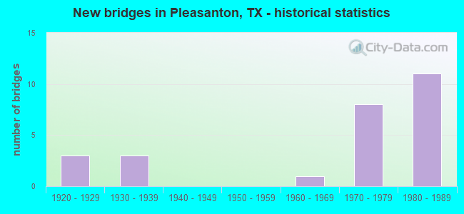
- New bridges - historical statistics
- 31920-1929
- 31930-1939
- 11960-1969
- 81970-1979
- 111980-1989

- Reconstructed bridges - Historical Statistics
- 11950-1959
- 31960-1969
- 11970-1979
- 11980-1989


- Bridge Condition - Deck
- 15.4%Very good
- 53.8%Good
- 30.8%Satisfactory

- Bridge Condition - Superstructure
- 46.2%Good
- 46.2%Satisfactory
- 7.7%Fair

- Bridge Condition - Substructure
- 46.2%Good
- 53.8%Satisfactory

- Bridge Condition - Channel
- 6.3%Very good
- 68.8%Good
- 25.0%Satisfactory

- Bridge Condition - Culverts
- 25.0%Good
- 75.0%Satisfactory
Find on map >> Show street view
Structure Number: 150070007303023, Location: 0.30 MI NE OF FM 3350 (Lat: 28.962792, Lng: -98.481072), Route carried "on" structure: US 281, Year Built: 1936, Year Reconstructed: 1960, Status: Open, Structure Length: 11.58m (37.99ft), Average Daily Traffic: 15,997 (year 2020), Truck Traffic: 9%, Average Future Daily Traffic: 29,540 (year 2033), Design Load: H 15, Features Intersected: ATASCOSA RIVER
Minimum Vertical Clearance: 30+ m (98+ ft), Kilometerpoint: 20.032, Lanes on structure: 4, Owner: State Highway Agency, Approaching Roadway Width: 20.7m (67.9ft), Skew: 3 degrees, Material/Design: Concrete, Design/Construction: Tee Beam, Number Of Spans In Main Unit: 11, Length of Maximum Span: 10.7m (35.1ft), Curb or Sidewalk Widths: Left: 1.2m (3.9ft), Right: 1.2m (3.9ft), Curb-To-Curb Width: 20.7m (67.9ft), Out-to-Out Width: 23.6m (77.4ft)
Condition: Deck: Good, Superstructure: Fair, Substructure: Satisfactory, Channel: Good, Operating Rating: 44.4 metric tons, Method Used To Determine Operating Rating: Load Factor (LF), Inventory Rating: 26.3 metric tons, Method Used To Determine Inventory Rating: Load Factor (LF), Structural Evaluation: Somewhat better than minimum adequacy, Deck Geometry: Superior to present desirable criteria, Waterway Adequacy: Equal to present minimum criteria, Approach Roadway Alignment: Equal to present desirable criteria, Designated Inspection Frequency: Every 24 months, Inspection Date: May 2020, Deck Structure Type: Concrete Cast-file-Place, Wearing Surface/Protective System: Wearing Surface: Bituminous
Find on map >> Show street view
Structure Number: 150070007304008, Location: 0.05 MI S OF SH 97 (Lat: 28.956292, Lng: -98.484181), Route carried "on" structure: US 281, Year Built: 1926, Year Reconstructed: 1960, Status: Open, Structure Length: 1.01m (3.31ft), Average Daily Traffic: 5,425 (year 2020), Truck Traffic: 9%, Average Future Daily Traffic: 12,720 (year 2033), Design Load: H 15, Features Intersected: BONITA CREEK RELIEF
Minimum Vertical Clearance: 30+ m (98+ ft), Kilometerpoint: 16.253, Lanes on structure: 4, Owner: State Highway Agency, Approaching Roadway Width: 20.4m (66.9ft), Material/Design: Concrete, Design/Construction: Culvert, Number Of Spans In Main Unit: 3, Length of Maximum Span: 3.0m (9.8ft), Curb-To-Curb Width: 20.4m (66.9ft), Out-to-Out Width: 23.6m (77.4ft)
Condition: Channel: Satisfactory, Culverts: Good, Operating Rating: 39.9 metric tons, Method Used To Determine Operating Rating: Load Factor (LF), Inventory Rating: 23.6 metric tons, Method Used To Determine Inventory Rating: Load Factor (LF), Structural Evaluation: Somewhat better than minimum adequacy, Deck Geometry: Superior to present desirable criteria, Waterway Adequacy: Equal to present minimum criteria, Approach Roadway Alignment: Equal to present desirable criteria, Length Of Structure Improvement: 1.07m (3.51ft), Designated Inspection Frequency: Every 24 months, Inspection Date: May 2020, Bridge Improvement Cost: $479,000, Roadway Improvement Cost: $47,000, Total Project Cost: $718,000, Deck Structure Type: Concrete Cast-file-Place, Wearing Surface/Protective System: Wearing Surface: Bituminous
Find on map >> Show street view
Structure Number: 150070007304009, Location: 0.10 MI S OF SH 97 (Lat: 28.955600, Lng: -98.484169), Route carried "on" structure: US 281, Year Built: 1926, Year Reconstructed: 1960, Status: Open, Structure Length: 1.01m (3.31ft), Average Daily Traffic: 5,425 (year 2020), Truck Traffic: 9%, Average Future Daily Traffic: 12,720 (year 2033), Design Load: H 15, Features Intersected: BONITA CREEK
Minimum Vertical Clearance: 30+ m (98+ ft), Kilometerpoint: 16.164, Lanes on structure: 4, Owner: State Highway Agency, Approaching Roadway Width: 20.4m (66.9ft), Material/Design: Concrete, Design/Construction: Culvert, Number Of Spans In Main Unit: 3, Length of Maximum Span: 3.0m (9.8ft), Curb or Sidewalk Widths: Left: 1.4m (4.6ft), Right: 1.4m (4.6ft), Curb-To-Curb Width: 20.4m (66.9ft), Out-to-Out Width: 23.6m (77.4ft)
Condition: Channel: Satisfactory, Culverts: Satisfactory, Operating Rating: 39.9 metric tons, Method Used To Determine Operating Rating: Load Factor (LF), Inventory Rating: 23.6 metric tons, Method Used To Determine Inventory Rating: Load Factor (LF), Structural Evaluation: Somewhat better than minimum adequacy, Deck Geometry: Superior to present desirable criteria, Waterway Adequacy: Equal to present minimum criteria, Approach Roadway Alignment: Equal to present desirable criteria, Length Of Structure Improvement: 1.07m (3.51ft), Designated Inspection Frequency: Every 24 months, Inspection Date: May 2020, Bridge Improvement Cost: $179,000, Roadway Improvement Cost: $17,000, Total Project Cost: $267,000, Deck Structure Type: Concrete Cast-file-Place, Wearing Surface/Protective System: Wearing Surface: Bituminous
Find on map >> Show street view
Structure Number: 150070007310243, Location: 0.55 MI N OF SH 97 (Lat: 29.002169, Lng: -98.431178), Route carried "on" structure: Interstate 37, Year Built: 1979, Status: Open, Structure Length: 0.82m (2.69ft), Average Daily Traffic: 29,000 (year 2013), Truck Traffic: 31%, Average Future Daily Traffic: 40,610 (year 2033), Design Load: HS 20, Features Intersected: DRAW
Minimum Vertical Clearance: 30+ m (98+ ft), Kilometerpoint: 17.785, Lanes on structure: 6, Owner: State Highway Agency, Approaching Roadway Width: 29.9m (98.1ft), Skew: 1 degrees, Material/Design: Concrete, Design/Construction: Culvert, Number Of Spans In Main Unit: 3, Length of Maximum Span: 2.4m (7.9ft)
Condition: Channel: Good, Culverts: Satisfactory, Operating Rating: 39.9 metric tons, Method Used To Determine Operating Rating: Load Factor (LF), Inventory Rating: 23.6 metric tons, Method Used To Determine Inventory Rating: Load Factor (LF), Structural Evaluation: Somewhat better than minimum adequacy, Waterway Adequacy: Equal to present minimum criteria, Approach Roadway Alignment: Equal to present desirable criteria, Designated Inspection Frequency: Every 48 months, Inspection Date: August 2018
Find on map >> Show street view
Structure Number: 150070007310244, Location: 4.00 MI S OF FM 3006 (Lat: 28.993683, Lng: -98.431131), Route carried "on" structure: State highway 97, Year Built: 1979, Status: Open, Structure Length: 9.27m (30.41ft), Average Daily Traffic: 7,100 (year 2013), Truck Traffic: 18%, Average Future Daily Traffic: 9,940 (year 2033), Design Load: HS 20, Features Intersected: IH 37
Minimum Vertical Clearance: 30+ m (98+ ft), Kilometerpoint: 21.726, Lanes on structure: 2, Lanes under structure: 5, Owner: State Highway Agency, Approaching Roadway Width: 11.6m (38.1ft), Skew: 2 degrees, Material/Design: Prestressed concrete, Design/Construction: Stringer/Multi-beam, Number Of Spans In Main Unit: 2, Number Of Approach Spans: 2, Length of Maximum Span: 31.1m (102.0ft), Curb-To-Curb Width: 11.6m (38.1ft), Out-to-Out Width: 12.3m (40.4ft)
Condition: Deck: Good, Superstructure: Good, Substructure: Good, Operating Rating: 54.4 metric tons, Method Used To Determine Operating Rating: Assigned rating based on Load Factor Design (LFD) reported in metric tons, Inventory Rating: 32.7 metric tons, Method Used To Determine Inventory Rating: Assigned rating based on Load Factor Design (LFD) reported in metric tons, Structural Evaluation: Better than present minimum criteria, Deck Geometry: Better than present minimum criteria, Underclear: Somewhat better than minimum adequacy, Approach Roadway Alignment: Equal to present desirable criteria, Designated Inspection Frequency: Every 24 months, Inspection Date: May 2020, Deck Structure Type: Concrete Cast-file-Place
Find on map >> Show street view
Structure Number: 150070007310245, Location: 4.00 MI S OF FM 3006 (Lat: 28.993800, Lng: -98.431156), Route carried "on" structure: State highway 97, Year Built: 1979, Status: Open, Structure Length: 9.27m (30.41ft), Average Daily Traffic: 7,100 (year 2013), Truck Traffic: 18%, Average Future Daily Traffic: 9,940 (year 2033), Design Load: HS 20, Features Intersected: IH 37
Minimum Vertical Clearance: 30+ m (98+ ft), Kilometerpoint: 21.726, Lanes on structure: 2, Lanes under structure: 5, Owner: State Highway Agency, Approaching Roadway Width: 11.6m (38.1ft), Skew: 2 degrees, Material/Design: Prestressed concrete, Design/Construction: Stringer/Multi-beam, Number Of Spans In Main Unit: 2, Number Of Approach Spans: 2, Length of Maximum Span: 31.1m (102.0ft), Curb-To-Curb Width: 11.6m (38.1ft), Out-to-Out Width: 12.3m (40.4ft)
Condition: Deck: Good, Superstructure: Satisfactory, Substructure: Good, Operating Rating: 54.4 metric tons, Method Used To Determine Operating Rating: Assigned rating based on Load Factor Design (LFD) reported in metric tons, Inventory Rating: 32.7 metric tons, Method Used To Determine Inventory Rating: Assigned rating based on Load Factor Design (LFD) reported in metric tons, Structural Evaluation: Equal to present minimum criteria, Deck Geometry: Better than present minimum criteria, Underclear: Somewhat better than minimum adequacy, Approach Roadway Alignment: Equal to present desirable criteria, Designated Inspection Frequency: Every 24 months, Inspection Date: May 2020, Deck Structure Type: Concrete Cast-file-Place
Find on map >> Show street view
Structure Number: 15007000731025, Location: 1.25 MI S OF SH 97 (Lat: 28.975592, Lng: -98.434197), Route carried "on" structure: County highway 299, Year Built: 1980, Status: Open, Structure Length: 8.23m (27.00ft), Average Daily Traffic: 455 (year 2010), Average Future Daily Traffic: 40 (year 2030), Design Load: H 15, Features Intersected: IH 37, Facility Carried by Structure: CORGEY RD
Minimum Vertical Clearance: 30+ m (98+ ft), Kilometerpoint: 2.575, Lanes on structure: 2, Lanes under structure: 5, Owner: State Highway Agency, Approaching Roadway Width: 6.7m (22.0ft), Skew: 1 degrees, Material/Design: Prestressed concrete, Design/Construction: Stringer/Multi-beam, Number Of Spans In Main Unit: 2, Number Of Approach Spans: 2, Length of Maximum Span: 29.0m (95.1ft), Curb-To-Curb Width: 7.9m (25.9ft), Out-to-Out Width: 8.5m (27.9ft)
Condition: Deck: Good, Superstructure: Satisfactory, Substructure: Satisfactory, Operating Rating: 60.8 metric tons, Method Used To Determine Operating Rating: Load Factor (LF), Inventory Rating: 22.7 metric tons, Method Used To Determine Inventory Rating: Load Factor (LF), Structural Evaluation: Equal to present minimum criteria, Deck Geometry: Somewhat better than minimum adequacy, Underclear: Somewhat better than minimum adequacy, Approach Roadway Alignment: Equal to present desirable criteria, Length Of Structure Improvement: 8.23m (27.00ft), Designated Inspection Frequency: Every 24 months, Inspection Date: May 2020, Bridge Improvement Cost: $14,000, Roadway Improvement Cost: $4,000, Total Project Cost: $18,000, Deck Structure Type: Concrete Precast Panels
Find on map >> Show street view
Structure Number: 150070007310251, Location: 2.20 MI S OF SH 97 (Lat: 28.962072, Lng: -98.437047), Route carried "on" structure: Interstate 37, Year Built: 1980, Status: Open, Structure Length: 29.57m (97.01ft), Average Daily Traffic: 12,408 (year 2019), Truck Traffic: 31%, Average Future Daily Traffic: 15,880 (year 2033), Design Load: HS 20, Features Intersected: UPRR & ATASCOSA RIVER
Minimum Vertical Clearance: 30+ m (98+ ft), Kilometerpoint: 12.878, Lanes on structure: 3, Owner: State Highway Agency, Approaching Roadway Width: 11.6m (38.1ft), Skew: 9 degrees, Material/Design: Prestressed concrete, Design/Construction: Stringer/Multi-beam, Number Of Spans In Main Unit: 15, Length of Maximum Span: 21.3m (69.9ft), Curb-To-Curb Width: 11.5m (37.7ft), Out-to-Out Width: 12.2m (40.0ft)
Condition: Deck: Satisfactory, Superstructure: Good, Substructure: Satisfactory, Channel: Very good, Operating Rating: 54.4 metric tons, Method Used To Determine Operating Rating: Assigned rating based on Load Factor Design (LFD) reported in metric tons, Inventory Rating: 32.7 metric tons, Method Used To Determine Inventory Rating: Assigned rating based on Load Factor Design (LFD) reported in metric tons, Structural Evaluation: Equal to present minimum criteria, Deck Geometry: High priority of replacement, Underclear: Equal to present desirable criteria, Waterway Adequacy: Superior to present desirable criteria, Approach Roadway Alignment: Equal to present desirable criteria, Designated Inspection Frequency: Every 24 months, Inspection Date: May 2020, Deck Structure Type: Concrete Precast Panels, Wearing Surface/Protective System: Wearing Surface: Bituminous
Find on map >> Show street view
Structure Number: 150070007310252, Location: 2.20 MI S OF SH 97 (Lat: 28.962081, Lng: -98.437150), Route carried "on" structure: Interstate 37, Year Built: 1980, Status: Open, Structure Length: 28.04m (91.99ft), Average Daily Traffic: 12,472 (year 2019), Truck Traffic: 31%, Average Future Daily Traffic: 15,880 (year 2033), Design Load: HS 20, Features Intersected: UPRR & ATASCOSA RIVER
Minimum Vertical Clearance: 30+ m (98+ ft), Kilometerpoint: 12.892, Lanes on structure: 2, Owner: State Highway Agency, Approaching Roadway Width: 11.6m (38.1ft), Skew: 9 degrees, Material/Design: Prestressed concrete, Design/Construction: Stringer/Multi-beam, Number Of Spans In Main Unit: 14, Length of Maximum Span: 21.3m (69.9ft), Curb-To-Curb Width: 11.5m (37.7ft), Out-to-Out Width: 12.2m (40.0ft)
Condition: Deck: Satisfactory, Superstructure: Satisfactory, Substructure: Satisfactory, Channel: Good, Operating Rating: 54.4 metric tons, Method Used To Determine Operating Rating: Assigned rating based on Load Factor Design (LFD) reported in metric tons, Inventory Rating: 32.7 metric tons, Method Used To Determine Inventory Rating: Assigned rating based on Load Factor Design (LFD) reported in metric tons, Structural Evaluation: Equal to present minimum criteria, Deck Geometry: Somewhat better than minimum adequacy, Underclear: Better than present minimum criteria, Waterway Adequacy: Superior to present desirable criteria, Approach Roadway Alignment: Equal to present desirable criteria, Designated Inspection Frequency: Every 24 months, Inspection Date: May 2020, Deck Structure Type: Concrete Precast Panels, Wearing Surface/Protective System: Wearing Surface: Bituminous
Find on map >> Show street view
Structure Number: 150070007310253, Location: 3.00 MI S OF SH 97 (Lat: 28.949778, Lng: -98.437325), Route carried "on" structure: Interstate 37, Year Built: 1980, Status: Open, Structure Length: 1.40m (4.59ft), Average Daily Traffic: 20,650 (year 2020), Truck Traffic: 31%, Average Future Daily Traffic: 31,770 (year 2033), Design Load: HS 20, Features Intersected: DRAW
Minimum Vertical Clearance: 30+ m (98+ ft), Kilometerpoint: 11.637, Lanes on structure: 4, Owner: State Highway Agency, Approaching Roadway Width: 23.2m (76.1ft), Skew: 4 degrees, Material/Design: Concrete, Design/Construction: Culvert, Number Of Spans In Main Unit: 3, Length of Maximum Span: 3.0m (9.8ft)
Condition: Channel: Good, Culverts: Satisfactory, Operating Rating: 39.9 metric tons, Method Used To Determine Operating Rating: Load Factor (LF), Inventory Rating: 23.6 metric tons, Method Used To Determine Inventory Rating: Load Factor (LF), Structural Evaluation: Somewhat better than minimum adequacy, Waterway Adequacy: Equal to present minimum criteria, Approach Roadway Alignment: Equal to present desirable criteria, Designated Inspection Frequency: Every 48 months, Inspection Date: August 2018
Find on map >> Show street view
Structure Number: 150070007310254, Location: 2.0 MI N OF SP 199 (Lat: 28.945242, Lng: -98.436767), Route carried "on" structure: County highway 294, Year Built: 1980, Status: Open, Structure Length: 8.23m (27.00ft), Average Daily Traffic: 250 (year 2010), Truck Traffic: 2%, Average Future Daily Traffic: 100 (year 2030), Design Load: HS 20, Features Intersected: IH 37, Facility Carried by Structure: COUGHRAN RD
Minimum Vertical Clearance: 30+ m (98+ ft), Kilometerpoint: 12.875, Lanes on structure: 2, Lanes under structure: 5, Owner: State Highway Agency, Approaching Roadway Width: 7.3m (24.0ft), Material/Design: Prestressed concrete, Design/Construction: Stringer/Multi-beam, Number Of Spans In Main Unit: 2, Number Of Approach Spans: 2, Length of Maximum Span: 29.0m (95.1ft), Curb-To-Curb Width: 10.3m (33.8ft), Out-to-Out Width: 11.0m (36.1ft)
Condition: Deck: Good, Superstructure: Satisfactory, Substructure: Good, Operating Rating: 54.4 metric tons, Method Used To Determine Operating Rating: Assigned rating based on Load Factor Design (LFD) reported in metric tons, Inventory Rating: 32.7 metric tons, Method Used To Determine Inventory Rating: Assigned rating based on Load Factor Design (LFD) reported in metric tons, Structural Evaluation: Equal to present minimum criteria, Deck Geometry: Better than present minimum criteria, Underclear: Somewhat better than minimum adequacy, Approach Roadway Alignment: Equal to present desirable criteria, Designated Inspection Frequency: Every 24 months, Inspection Date: May 2020, Deck Structure Type: Concrete Precast Panels
Find on map >> Show street view
Structure Number: 150070007310255, Location: 1.0 MI N OF SPUR 199 (Lat: 28.930839, Lng: -98.435444), Route carried "on" structure: Interstate 37, Year Built: 1980, Status: Open, Structure Length: 1.68m (5.51ft), Average Daily Traffic: 12,091 (year 2019), Truck Traffic: 31%, Average Future Daily Traffic: 14,200 (year 2033), Design Load: HS 20, Features Intersected: GEORGETOWN CREEK
Minimum Vertical Clearance: 30+ m (98+ ft), Kilometerpoint: 9.547, Lanes on structure: 2, Owner: State Highway Agency, Approaching Roadway Width: 11.6m (38.1ft), Skew: 1 degrees, Material/Design: Concrete, Design/Construction: Culvert, Number Of Spans In Main Unit: 5, Length of Maximum Span: 3.0m (9.8ft)
Condition: Channel: Good, Culverts: Satisfactory, Operating Rating: 39.9 metric tons, Method Used To Determine Operating Rating: Load Factor (LF), Inventory Rating: 23.6 metric tons, Method Used To Determine Inventory Rating: Load Factor (LF), Structural Evaluation: Somewhat better than minimum adequacy, Waterway Adequacy: Equal to present minimum criteria, Approach Roadway Alignment: Equal to present desirable criteria, Designated Inspection Frequency: Every 48 months, Inspection Date: August 2018
Find on map >> Show street view
Structure Number: 150070007310256, Location: 1.0 MI N OF SPUR 199 (Lat: 28.930831, Lng: -98.435556), Route carried "on" structure: Interstate 37, Year Built: 1980, Status: Open, Structure Length: 1.68m (5.51ft), Average Daily Traffic: 12,353 (year 2019), Truck Traffic: 31%, Average Future Daily Traffic: 14,200 (year 2033), Design Load: HS 20, Features Intersected: GEORGETOWN CREEK
Minimum Vertical Clearance: 30+ m (98+ ft), Kilometerpoint: 9.531, Lanes on structure: 2, Owner: State Highway Agency, Approaching Roadway Width: 11.6m (38.1ft), Skew: 1 degrees, Material/Design: Concrete, Design/Construction: Culvert, Number Of Spans In Main Unit: 5, Length of Maximum Span: 3.0m (9.8ft)
Condition: Channel: Good, Culverts: Good, Operating Rating: 39.9 metric tons, Method Used To Determine Operating Rating: Load Factor (LF), Inventory Rating: 23.6 metric tons, Method Used To Determine Inventory Rating: Load Factor (LF), Structural Evaluation: Somewhat better than minimum adequacy, Waterway Adequacy: Equal to present minimum criteria, Approach Roadway Alignment: Equal to present desirable criteria, Designated Inspection Frequency: Every 48 months, Inspection Date: August 2018
Find on map >> Show street view
Structure Number: 150070007310257, Location: 5.40 MI S OF SH 97 (Lat: 28.916136, Lng: -98.434786), Route carried "on" structure: State highway 199, Year Built: 1980, Status: Open, Structure Length: 8.23m (27.00ft), Average Daily Traffic: 2,490 (year 2013), Truck Traffic: 6%, Average Future Daily Traffic: 3,490 (year 2033), Design Load: H 15, Features Intersected: IH 37
Minimum Vertical Clearance: 30+ m (98+ ft), Kilometerpoint: 2.586, Lanes on structure: 2, Lanes under structure: 5, Owner: State Highway Agency, Approaching Roadway Width: 7.3m (24.0ft), Material/Design: Prestressed concrete, Design/Construction: Stringer/Multi-beam, Number Of Spans In Main Unit: 2, Number Of Approach Spans: 2, Length of Maximum Span: 29.0m (95.1ft), Curb-To-Curb Width: 7.9m (25.9ft), Out-to-Out Width: 8.5m (27.9ft)
Condition: Deck: Very good, Superstructure: Good, Substructure: Good, Operating Rating: 59.9 metric tons, Method Used To Determine Operating Rating: Load Factor (LF), Inventory Rating: 20.9 metric tons, Method Used To Determine Inventory Rating: Load Factor (LF), Structural Evaluation: Somewhat better than minimum adequacy, Deck Geometry: High priority of corrective action, Underclear: Somewhat better than minimum adequacy, Approach Roadway Alignment: Equal to present desirable criteria, Designated Inspection Frequency: Every 24 months, Inspection Date: May 2020, Deck Structure Type: Concrete Precast Panels, Wearing Surface/Protective System: Wearing Surface: Bituminous
Find on map >> Show street view
Structure Number: 150070032803024, Location: 1.90 MI SW OF IH 37 (Lat: 28.981097, Lng: -98.460736), Route carried "on" structure: State highway 97, Year Built: 1938, Year Reconstructed: 1962, Status: Open, Structure Length: 6.40m (21.00ft), Average Daily Traffic: 7,100 (year 2013), Truck Traffic: 18%, Average Future Daily Traffic: 9,940 (year 2033), Design Load: H 15, Features Intersected: GALVAN CREEK
Minimum Vertical Clearance: 30+ m (98+ ft), Kilometerpoint: 18.527, Lanes on structure: 2, Owner: State Highway Agency, Approaching Roadway Width: 11.0m (36.1ft), Skew: 3 degrees, Material/Design: Steel, Design/Construction: Stringer/Multi-beam, Number Of Spans In Main Unit: 6, Length of Maximum Span: 10.7m (35.1ft), Curb-To-Curb Width: 10.8m (35.4ft), Out-to-Out Width: 11.9m (39.0ft)
Condition: Deck: Satisfactory, Superstructure: Good, Substructure: Satisfactory, Channel: Good, Operating Rating: 44.4 metric tons, Method Used To Determine Operating Rating: Load Factor (LF), Inventory Rating: 27.2 metric tons, Method Used To Determine Inventory Rating: Load Factor (LF), Structural Evaluation: Equal to present minimum criteria, Deck Geometry: Somewhat better than minimum adequacy, Waterway Adequacy: Equal to present minimum criteria, Approach Roadway Alignment: Equal to present desirable criteria, Designated Inspection Frequency: Every 24 months, Inspection Date: May 2020, Deck Structure Type: Concrete Cast-file-Place, Wearing Surface/Protective System: Wearing Surface: Bituminous
Find on map >> Show street view
Structure Number: 150070032803046, Location: 1.90 MI SW OF IH 37 (Lat: 28.981206, Lng: -98.460786), Route carried "on" structure: State highway 97, Year Built: 1972, Status: Open, Structure Length: 6.40m (21.00ft), Average Daily Traffic: 7,100 (year 2013), Truck Traffic: 18%, Average Future Daily Traffic: 9,940 (year 2033), Design Load: HS 20, Features Intersected: GALVAN CREEK
Minimum Vertical Clearance: 30+ m (98+ ft), Kilometerpoint: 18.511, Lanes on structure: 2, Owner: State Highway Agency, Approaching Roadway Width: 11.0m (36.1ft), Skew: 3 degrees, Material/Design: Prestressed concrete, Design/Construction: Stringer/Multi-beam, Number Of Spans In Main Unit: 3, Length of Maximum Span: 21.3m (69.9ft), Curb-To-Curb Width: 12.3m (40.4ft), Out-to-Out Width: 12.9m (42.3ft)
Condition: Deck: Very good, Superstructure: Good, Substructure: Good, Channel: Good, Operating Rating: 54.4 metric tons, Method Used To Determine Operating Rating: Assigned rating based on Load Factor Design (LFD) reported in metric tons, Inventory Rating: 32.7 metric tons, Method Used To Determine Inventory Rating: Assigned rating based on Load Factor Design (LFD) reported in metric tons, Structural Evaluation: Better than present minimum criteria, Deck Geometry: Better than present minimum criteria, Waterway Adequacy: Equal to present minimum criteria, Approach Roadway Alignment: Equal to present desirable criteria, Designated Inspection Frequency: Every 24 months, Inspection Date: May 2020, Deck Structure Type: Concrete Cast-file-Place, Wearing Surface/Protective System: Wearing Surface: Bituminous
Find on map >> Show street view
Structure Number: 150070032803246, Location: 0.20 MI SW OF IH 37 (Lat: 28.992417, Lng: -98.434233), Route carried "on" structure: State highway 97, Year Built: 1979, Status: Open, Structure Length: 1.19m (3.90ft), Average Daily Traffic: 9,500 (year 2020), Truck Traffic: 18%, Average Future Daily Traffic: 19,890 (year 2033), Design Load: HS 20, Features Intersected: PRESLEANO CREEK
Minimum Vertical Clearance: 30+ m (98+ ft), Kilometerpoint: 21.440, Lanes on structure: 4, Owner: State Highway Agency, Approaching Roadway Width: 23.2m (76.1ft), Material/Design: Concrete, Design/Construction: Culvert, Number Of Spans In Main Unit: 4, Length of Maximum Span: 2.7m (8.9ft)
Condition: Channel: Satisfactory, Culverts: Satisfactory, Operating Rating: 39.9 metric tons, Method Used To Determine Operating Rating: Load Factor (LF), Inventory Rating: 23.6 metric tons, Method Used To Determine Inventory Rating: Load Factor (LF), Structural Evaluation: Somewhat better than minimum adequacy, Waterway Adequacy: Equal to present minimum criteria, Approach Roadway Alignment: Equal to present desirable criteria, Length Of Structure Improvement: 1.22m (4.00ft), Designated Inspection Frequency: Every 48 months, Inspection Date: May 2020, Bridge Improvement Cost: $200,000, Roadway Improvement Cost: $20,000, Total Project Cost: $300,000
Find on map >> Show street view
Structure Number: 150070032804006, Location: 1.15 MI SW OF US 281 (Lat: 28.949592, Lng: -98.499511), Route carried "on" structure: State highway 97, Year Built: 1926, Year Reconstructed: 1985, Status: Open, Structure Length: 1.34m (4.40ft), Average Daily Traffic: 19,920 (year 2020), Truck Traffic: 2%, Average Future Daily Traffic: 35,170 (year 2033), Design Load: H 15, Features Intersected: BONITA CREEK
Minimum Vertical Clearance: 30+ m (98+ ft), Kilometerpoint: 5.464, Lanes on structure: 5, Owner: State Highway Agency, Approaching Roadway Width: 20.4m (66.9ft), Material/Design: Concrete, Design/Construction: Culvert, Number Of Spans In Main Unit: 4, Length of Maximum Span: 3.0m (9.8ft), Curb or Sidewalk Widths: Left: 1.8m (5.9ft), Right: 1.8m (5.9ft), Curb-To-Curb Width: 20.4m (66.9ft), Out-to-Out Width: 32.7m (107.3ft)
Condition: Channel: Good, Culverts: Satisfactory, Operating Rating: 39.9 metric tons, Method Used To Determine Operating Rating: Load Factor (LF), Inventory Rating: 23.6 metric tons, Method Used To Determine Inventory Rating: Load Factor (LF), Structural Evaluation: Somewhat better than minimum adequacy, Deck Geometry: Somewhat better than minimum adequacy, Waterway Adequacy: Equal to present minimum criteria, Approach Roadway Alignment: Equal to present desirable criteria, Designated Inspection Frequency: Every 24 months, Inspection Date: May 2020, Deck Structure Type: Concrete Cast-file-Place, Wearing Surface/Protective System: Wearing Surface: Bituminous
Find on map >> Show street view
Structure Number: 150070032810036, Location: 0.20 MI W OF US 281 (Lat: 28.971961, Lng: -98.481922), Route carried "on" structure: Spur State highway 242, Year Built: 1930, Year Reconstructed: 1984, Status: Open, Structure Length: 7.71m (25.30ft), Average Daily Traffic: 6,700 (year 2020), Truck Traffic: 12%, Average Future Daily Traffic: 11,800 (year 2033), Design Load: H 15, Features Intersected: ATASCOSA RIVER
Minimum Vertical Clearance: 30+ m (98+ ft), Kilometerpoint: 1.283, Lanes on structure: 2, Owner: State Highway Agency, Approaching Roadway Width: 13.4m (44.0ft), Material/Design: Steel, Design/Construction: Stringer/Multi-beam, Number Of Spans In Main Unit: 3, Number Of Approach Spans: 7, Length of Maximum Span: 12.2m (40.0ft), Curb or Sidewalk Widths: Left: 0.0m, Right: 1.6m (5.2ft), Curb-To-Curb Width: 13.5m (44.3ft), Out-to-Out Width: 15.9m (52.2ft)
Condition: Deck: Good, Superstructure: Satisfactory, Substructure: Satisfactory, Channel: Satisfactory, Operating Rating: 52.6 metric tons, Method Used To Determine Operating Rating: Load Factor (LF), Inventory Rating: 24.5 metric tons, Method Used To Determine Inventory Rating: Load Factor (LF), Structural Evaluation: Equal to present minimum criteria, Deck Geometry: Superior to present desirable criteria, Waterway Adequacy: Equal to present minimum criteria, Approach Roadway Alignment: Equal to present desirable criteria, Designated Inspection Frequency: Every 24 months, Inspection Date: May 2020, Deck Structure Type: Concrete Cast-file-Place, Wearing Surface/Protective System: Wearing Surface: Bituminous
Find on map >> Show street view
Structure Number: 150070085302005, Location: 2.15 MI NW OF LP 242 (Lat: 29.000158, Lng: -98.511886), Route carried "on" structure: State highway 476, Year Built: 1962, Status: Open, Structure Length: 9.75m (31.99ft), Average Daily Traffic: 5,470 (year 2020), Truck Traffic: 2%, Average Future Daily Traffic: 8,950 (year 2033), Design Load: H 20, Features Intersected: ATASCOSA RIVER
Minimum Vertical Clearance: 30+ m (98+ ft), Kilometerpoint: 7.802, Lanes on structure: 2, Owner: State Highway Agency, Approaching Roadway Width: 10.7m (35.1ft), Material/Design: Concrete, Design/Construction: Stringer/Multi-beam, Number Of Spans In Main Unit: 8, Length of Maximum Span: 12.2m (40.0ft), Curb-To-Curb Width: 8.5m (27.9ft), Out-to-Out Width: 9.5m (31.2ft)
Condition: Deck: Satisfactory, Superstructure: Satisfactory, Substructure: Satisfactory, Channel: Good, Operating Rating: 49.9 metric tons, Method Used To Determine Operating Rating: Load Factor (LF), Inventory Rating: 29.9 metric tons, Method Used To Determine Inventory Rating: Load Factor (LF), Structural Evaluation: Equal to present minimum criteria, Deck Geometry: Meets minimum limits, Waterway Adequacy: Equal to present minimum criteria, Approach Roadway Alignment: Equal to present desirable criteria, Length Of Structure Improvement: 9.75m (31.99ft), Designated Inspection Frequency: Every 24 months, Inspection Date: May 2020, Deck Structure Type: Concrete Cast-file-Place, Wearing Surface/Protective System: Wearing Surface: Bituminous
Find on map >> Show street view
Structure Number: 150070310501001, Location: 0.85 MI NE OF US 281 (Lat: 29.018961, Lng: -98.466647), Route carried "on" structure: State highway 3006, Year Built: 1971, Status: Open, Structure Length: 5.09m (16.70ft), Average Daily Traffic: 1,695 (year 2020), Truck Traffic: 46%, Average Future Daily Traffic: 3,490 (year 2033), Design Load: HS 20, Features Intersected: GALVAN CREEK
Minimum Vertical Clearance: 30+ m (98+ ft), Kilometerpoint: 6.247, Lanes on structure: 2, Owner: State Highway Agency, Approaching Roadway Width: 12.8m (42.0ft), Skew: 2 degrees, Material/Design: Concrete, Design/Construction: Stringer/Multi-beam, Number Of Spans In Main Unit: 4, Length of Maximum Span: 12.8m (42.0ft), Curb-To-Curb Width: 13.4m (44.0ft), Out-to-Out Width: 14.1m (46.3ft)
Condition: Deck: Good, Superstructure: Good, Substructure: Good, Channel: Good, Operating Rating: 68.0 metric tons, Method Used To Determine Operating Rating: Load Factor (LF), Inventory Rating: 40.8 metric tons, Method Used To Determine Inventory Rating: Load Factor (LF), Structural Evaluation: Better than present minimum criteria, Deck Geometry: Equal to present desirable criteria, Waterway Adequacy: Better than present minimum criteria, Approach Roadway Alignment: Equal to present desirable criteria, Designated Inspection Frequency: Every 24 months, Inspection Date: May 2020, Deck Structure Type: Concrete Cast-file-Place
Find on map >> Show street view
Structure Number: 150070007310244, Location: 4.00 MI S OF FM 3006 (Lat: 28.993683, Lng: -98.431131), Route carried "under" structure: Interstate 37, Year Built: 1979, Structure Length: 0. m, Average Daily Traffic: 16,110 (year 2010), Truck Traffic: 26%, Features Intersected: IH 37, Facility Carried by Structure: SH 97 EB
Minimum Vertical Clearance: 5.59m (18.34ft), Kilometerpoint: 16.430, Lanes on structure: 2, Lanes under structure: 5, Material/Design: Prestressed concrete, Design/Construction: Stringer/Multi-beam, Length of Maximum Span: 31.1m (102.0ft)
Find on map >> Show street view
Structure Number: 150070007310245, Location: 4.00 MI S OF FM 3006 (Lat: 28.993800, Lng: -98.431156), Route carried "under" structure: Interstate 37, Year Built: 1979, Structure Length: 0. m, Average Daily Traffic: 19,700 (year 2010), Truck Traffic: 24%, Features Intersected: IH 37, Facility Carried by Structure: SH 97 WB
Minimum Vertical Clearance: 5.54m (18.18ft), Kilometerpoint: 16.454, Lanes on structure: 2, Lanes under structure: 5, Material/Design: Prestressed concrete, Design/Construction: Stringer/Multi-beam, Length of Maximum Span: 31.1m (102.0ft)
Find on map >> Show street view
Structure Number: 15007000731025, Location: 1.25 MI S OF SH 97 (Lat: 28.975592, Lng: -98.434197), Route carried "under" structure: Interstate 37, Year Built: 1980, Structure Length: 0. m, Average Daily Traffic: 16,110 (year 2010), Truck Traffic: 26%, Features Intersected: IH 37, Facility Carried by Structure: CORGEY RD
Minimum Vertical Clearance: 5.18m (16.99ft), Kilometerpoint: 14.392, Lanes on structure: 2, Lanes under structure: 5, Material/Design: Prestressed concrete, Design/Construction: Stringer/Multi-beam, Length of Maximum Span: 29.0m (95.1ft)
Find on map >> Show street view
Structure Number: 150070007310254, Location: 2.0 MI N OF SP 199 (Lat: 28.945242, Lng: -98.436767), Route carried "under" structure: Interstate 37, Year Built: 1980, Structure Length: 0. m, Average Daily Traffic: 15,080 (year 2010), Truck Traffic: 27%, Features Intersected: IH 37, Facility Carried by Structure: COUGHRAN RD
Minimum Vertical Clearance: 5.05m (16.57ft), Kilometerpoint: 10.997, Lanes on structure: 2, Lanes under structure: 5, Material/Design: Prestressed concrete, Design/Construction: Stringer/Multi-beam, Length of Maximum Span: 29.0m (95.1ft)
Find on map >> Show street view
Structure Number: 150070007310257, Location: 5.40 MI S OF SH 97 (Lat: 28.916136, Lng: -98.434786), Route carried "under" structure: Interstate 37, Year Built: 1980, Structure Length: 0. m, Average Daily Traffic: 20,290 (year 2013), Truck Traffic: 31%, Features Intersected: IH 37, Facility Carried by Structure: SP 199
Minimum Vertical Clearance: 5.18m (16.99ft), Kilometerpoint: 7.767, Lanes on structure: 2, Lanes under structure: 5, Material/Design: Prestressed concrete, Design/Construction: Stringer/Multi-beam, Length of Maximum Span: 29.0m (95.1ft)