Bridge Statistics for Radford, Virginia (VA)
Condition, Traffic, Stress, Structural Evaluation, Project Costs
- National Bridge Inventory (NBI) Statistics
- 24Number of bridges
- 502ft / 153mTotal length
- $41,621,000Total costs
- 202,319Total average daily traffic
- 45,866Total average daily truck traffic
- National Bridge Inventory (NBI) Registered Bridges for Radford
- No street view available for this location
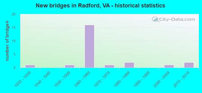
- New bridges - historical statistics
- 11930-1939
- 11950-1959
- 161960-1969
- 11970-1979
- 21980-1989
- 12000-2009
- 22010-2019

- Reconstructed bridges - Historical Statistics
- 31980-1989
- 11990-1999


- Bridge Condition - Deck
- 7.7%Very good
- 30.8%Good
- 38.5%Satisfactory
- 7.7%Fair
- 15.4%Poor

- Bridge Condition - Superstructure
- 23.1%Very good
- 7.7%Good
- 15.4%Satisfactory
- 38.5%Fair
- 15.4%Poor

- Bridge Condition - Substructure
- 7.7%Very good
- 23.1%Good
- 23.1%Satisfactory
- 30.8%Fair
- 15.4%Serious

- Bridge Condition - Channel
- 7.1%Very good
- 35.7%Good
- 42.9%Satisfactory
- 14.3%Fair
Find on map >> Show street view
Structure Number: 3485, Location: 0.08-Rte779; 0.65-end mt (Lat: 37.426703, Lng: -79.939064), Route carried "on" structure: County highway 672, Year Built: 1971, Status: Open, Structure Length: 0.94m (3.08ft), Average Daily Traffic: 176 (year 2016), Average Future Daily Traffic: 203 (year 2040), Design Load: H 20, Features Intersected: Tinker Creek
Minimum Vertical Clearance: 30+ m (98+ ft), Kilometerpoint: 0.909, Lanes on structure: 2, Owner: State Highway Agency, Approaching Roadway Width: 5.5m (18.0ft), Material/Design: Steel, Design/Construction: Culvert, Number Of Spans In Main Unit: 2, Length of Maximum Span: 4.3m (14.1ft)
Condition: Channel: Satisfactory, Culverts: Satisfactory, Operating Rating: 44.5 metric tons, Method Used To Determine Operating Rating: Field evaluation and documented engineering judgment, Inventory Rating: 32.7 metric tons, Method Used To Determine Inventory Rating: Field evaluation and documented engineering judgment, Structural Evaluation: Equal to present minimum criteria, Waterway Adequacy: Equal to present minimum criteria, Approach Roadway Alignment: Equal to present desirable criteria, Length Of Structure Improvement: 0.94m (3.08ft), Designated Inspection Frequency: Every 24 months, Inspection Date: November 2020, Bridge Improvement Cost: $444,000, Roadway Improvement Cost: $111,000, Total Project Cost: $1,421,000 ( Estimate for 2020)
Find on map >> Show street view
Structure Number: 3922, Location: 2.6 M To 691&3.8 M FR 670 (Lat: 37.388000, Lng: -82.158242), Route carried "on" structure: County highway 645, Year Built: 1961, Status: Open, Structure Length: 0.88m (2.89ft), Average Daily Traffic: 679 (year 2020), Truck Traffic: 5%, Average Future Daily Traffic: 747 (year 2040), Design Load: HS 20, Features Intersected: ROCKLICK CREEK, Facility Carried by Structure: OLD ROCKLICK RD.
Minimum Vertical Clearance: 30+ m (98+ ft), Kilometerpoint: 5.768, Lanes on structure: 2, Owner: State Highway Agency, Approaching Roadway Width: 6.4m (21.0ft), Skew: 4 degrees, Material/Design: Concrete, Design/Construction: Culvert, Number Of Spans In Main Unit: 2, Length of Maximum Span: 4.3m (14.1ft)
Condition: Channel: Satisfactory, Culverts: Satisfactory, Operating Rating: 44.5 metric tons, Method Used To Determine Operating Rating: Field evaluation and documented engineering judgment, Inventory Rating: 32.7 metric tons, Method Used To Determine Inventory Rating: Field evaluation and documented engineering judgment, Structural Evaluation: Equal to present minimum criteria, Waterway Adequacy: Better than present minimum criteria, Approach Roadway Alignment: Better than present minimum criteria, Length Of Structure Improvement: 0.88m (2.89ft), Designated Inspection Frequency: Every 24 months, Inspection Date: December 2021, Bridge Improvement Cost: $50,000, Roadway Improvement Cost: $15,000, Total Project Cost: $135,000 ( Estimate for 2015)
Find on map >> Show street view
Structure Number: 3923, Location: 4.2 M to 670&2.2 M FR 691 (Lat: 37.388383, Lng: -82.163658), Route carried "on" structure: County highway 645, Year Built: 1961, Status: Open, Structure Length: 0.73m (2.40ft), Average Daily Traffic: 679 (year 2020), Truck Traffic: 5%, Average Future Daily Traffic: 747 (year 2040), Design Load: H 20, Features Intersected: ROCKLICK CREEK, Facility Carried by Structure: OLD ROCKLICK RD.
Minimum Vertical Clearance: 30+ m (98+ ft), Kilometerpoint: 5.416, Lanes on structure: 2, Owner: State Highway Agency, Approaching Roadway Width: 6.4m (21.0ft), Skew: 4 degrees, Material/Design: Concrete, Design/Construction: Culvert, Number Of Spans In Main Unit: 2, Length of Maximum Span: 3.4m (11.2ft)
Condition: Channel: Satisfactory, Culverts: Satisfactory, Operating Rating: 44.5 metric tons, Method Used To Determine Operating Rating: Field evaluation and documented engineering judgment, Inventory Rating: 32.7 metric tons, Method Used To Determine Inventory Rating: Field evaluation and documented engineering judgment, Structural Evaluation: Equal to present minimum criteria, Waterway Adequacy: Better than present minimum criteria, Approach Roadway Alignment: Better than present minimum criteria, Length Of Structure Improvement: 0.73m (2.40ft), Designated Inspection Frequency: Every 24 months, Inspection Date: December 2021, Bridge Improvement Cost: $30,000, Roadway Improvement Cost: $10,000, Total Project Cost: $101,000 ( Estimate for 2015)
Find on map >> Show street view
Structure Number: 3924, Location: .00FRRT460;.01TORT700 (Lat: 37.354264, Lng: -82.189175), Route carried "on" structure: County highway 645, Year Built: 1966, Year Reconstructed: 2001, Status: Open, Structure Length: 6.70m (21.98ft), Average Daily Traffic: 2,124 (year 2020), Truck Traffic: 5%, Average Future Daily Traffic: 2,336 (year 2040), Design Load: HS 20+Mod, Features Intersected: LEVISA RIVER, Facility Carried by Structure: OLD ROCKLICK RD.
Minimum Vertical Clearance: 30+ m (98+ ft), Kilometerpoint: 0.000, Lanes on structure: 2, Owner: State Highway Agency, Approaching Roadway Width: 7.0m (23.0ft), Material/Design: Steel, Design/Construction: Stringer/Multi-beam, Number Of Spans In Main Unit: 3, Length of Maximum Span: 22.6m (74.1ft), Curb or Sidewalk Widths: Left: 1.2m (3.9ft), Right: 0.5m (1.6ft), Curb-To-Curb Width: 7.3m (24.0ft), Out-to-Out Width: 9.5m (31.2ft)
Condition: Deck: Poor, Superstructure: Satisfactory, Substructure: Serious, Channel: Good, Operating Rating: 70.8 metric tons, Method Used To Determine Operating Rating: Load and Resistance Factor (LRFR), Inventory Rating: 54.4 metric tons, Method Used To Determine Inventory Rating: Load and Resistance Factor (LRFR), Structural Evaluation: High priority of corrective action, Deck Geometry: High priority of replacement, Waterway Adequacy: Better than present minimum criteria, Approach Roadway Alignment: Better than present minimum criteria, Length Of Structure Improvement: 6.71m (22.01ft), Designated Inspection Frequency: Every 12 months, Inspection Date: December 2021, Bridge Improvement Cost: $520,000, Roadway Improvement Cost: $25,000, Total Project Cost: $920,000 ( Estimate for 2019), Deck Structure Type: Concrete Cast-file-Place, Wearing Surface/Protective System: Wearing Surface: Monolithic Concrete
Find on map >> Show street view
Structure Number: 3925, Location: 0.0M FR 647 & 2.8M TO 643 (Lat: 37.434608, Lng: -81.992192), Route carried "on" structure: County highway 646, Year Built: 1982, Status: Open, Structure Length: 1.01m (3.31ft), Average Daily Traffic: 856 (year 2020), Truck Traffic: 2%, Average Future Daily Traffic: 942 (year 2040), Design Load: HS 20+Mod, Features Intersected: GUESS FORK
Minimum Vertical Clearance: 30+ m (98+ ft), Kilometerpoint: 4.634, Lanes on structure: 2, Owner: State Highway Agency, Approaching Roadway Width: 5.5m (18.0ft), Skew: 4 degrees, Material/Design: Concrete, Design/Construction: Slab, Number Of Spans In Main Unit: 1, Length of Maximum Span: 9.5m (31.2ft), Curb-To-Curb Width: 7.9m (25.9ft), Out-to-Out Width: 8.5m (27.9ft)
Condition: Deck: Satisfactory, Superstructure: Satisfactory, Substructure: Serious, Channel: Fair, Operating Rating: 89.8 metric tons, Method Used To Determine Operating Rating: Load and Resistance Factor (LRFR), Inventory Rating: 88.9 metric tons, Method Used To Determine Inventory Rating: Load and Resistance Factor (LRFR), Structural Evaluation: High priority of corrective action, Deck Geometry: Somewhat better than minimum adequacy, Waterway Adequacy: Better than present minimum criteria, Approach Roadway Alignment: Better than present minimum criteria, Designated Inspection Frequency: Every 24 months, Inspection Date: June 2020, Deck Structure Type: Concrete Cast-file-Place
Find on map >> Show street view
Structure Number: 12111, Location: 0.46-RT783;2.11-RT177 (Lat: 37.131906, Lng: -80.519550), Route carried "on" structure: US 11, Year Built: 1988, Status: Open, Structure Length: 4.48m (14.70ft), Average Daily Traffic: 4,600 (year 2020), Truck Traffic: 1%, Average Future Daily Traffic: 5,060 (year 2040), Design Load: HS 20+Mod, Features Intersected: PLUM CREEK
Minimum Vertical Clearance: 30+ m (98+ ft), Kilometerpoint: 179.392, Lanes on structure: 2, Base Highway Network: Yes, Owner: State Highway Agency, Approaching Roadway Width: 7.3m (24.0ft), Material/Design: Concrete continuous, Design/Construction: Slab, Number Of Spans In Main Unit: 3, Length of Maximum Span: 16.8m (55.1ft), Curb-To-Curb Width: 13.4m (44.0ft), Out-to-Out Width: 14.4m (47.2ft)
Condition: Deck: Good, Superstructure: Good, Substructure: Good, Channel: Good, Operating Rating: 89.8 metric tons, Method Used To Determine Operating Rating: Load and Resistance Factor (LRFR), Inventory Rating: 69.9 metric tons, Method Used To Determine Inventory Rating: Load and Resistance Factor (LRFR), Structural Evaluation: Better than present minimum criteria, Deck Geometry: Better than present minimum criteria, Waterway Adequacy: Equal to present desirable criteria, Approach Roadway Alignment: Equal to present desirable criteria, Designated Inspection Frequency: Every 24 months, Inspection Date: Febuary 2021, Deck Structure Type: Concrete Cast-file-Place, Wearing Surface/Protective System: Wearing Surface: Latex Concrete, Deck Protection: Epoxy Coated Reinforcing
Find on map >> Show street view
Structure Number: 12159, Location: 0.00-PULASK & 0.00-MONTG (Lat: 37.088408, Lng: -80.582853), Route carried "on" structure: Interstate 81, Year Built: 1965, Year Reconstructed: 1986, Status: Open, Structure Length: 50.58m (165.94ft), Average Daily Traffic: 17,025 (year 2020), Truck Traffic: 26%, Average Future Daily Traffic: 23,835 (year 2040), Design Load: HS 20+Mod, Features Intersected: NEW RV; NS RWY & RT605
Minimum Vertical Clearance: 10.06m (33.01ft), Kilometerpoint: 169.846, Lanes on structure: 2, Lanes under structure: 2, Base Highway Network: Yes, Owner: State Highway Agency, Approaching Roadway Width: 12.2m (40.0ft), Material/Design: Steel continuous, Design/Construction: Stringer/Multi-beam, Number Of Spans In Main Unit: 8, Number Of Approach Spans: 2, Length of Maximum Span: 53.6m (175.9ft), Curb or Sidewalk Widths: Left: 0.2m (0.7ft), Right: 0.2m (0.7ft), Curb-To-Curb Width: 11.8m (38.7ft), Out-to-Out Width: 12.8m (42.0ft)
Condition: Deck: Fair, Superstructure: Fair, Substructure: Satisfactory, Channel: Very good, Operating Rating: 59.9 metric tons, Method Used To Determine Operating Rating: Load Factor (LF), Inventory Rating: 35.4 metric tons, Method Used To Determine Inventory Rating: Load Factor (LF), Structural Evaluation: Somewhat better than minimum adequacy, Deck Geometry: Equal to present minimum criteria, Underclear: Equal to present minimum criteria, Waterway Adequacy: Superior to present desirable criteria, Approach Roadway Alignment: Equal to present desirable criteria, Designated Inspection Frequency: Every 24 months, Underwater Inspection Frequency: Every 60 months, Inspection Date: April 2020, Underwater Inspection Date: August 2017, Deck Structure Type: Concrete Precast Panels, Wearing Surface/Protective System: Deck Protection: Epoxy Coated Reinforcing
Find on map >> Show street view
Structure Number: 12161, Location: 0.00PULAS CO;0.00MONTG CO (Lat: 37.088100, Lng: -80.582800), Route carried "on" structure: Interstate 81, Year Built: 1965, Year Reconstructed: 1985, Status: Temporarily open, Structure Length: 48.77m (160.01ft), Average Daily Traffic: 18,556 (year 2020), Truck Traffic: 27%, Average Future Daily Traffic: 25,978 (year 2040), Design Load: HS 20+Mod, Features Intersected: NEW RIVER & ROUTE 605
Minimum Vertical Clearance: 10.67m (35.01ft), Kilometerpoint: 168.929, Lanes on structure: 2, Lanes under structure: 2, Base Highway Network: Yes, Owner: State Highway Agency, Approaching Roadway Width: 12.2m (40.0ft), Material/Design: Steel continuous, Design/Construction: Stringer/Multi-beam, Number Of Spans In Main Unit: 10, Length of Maximum Span: 53.6m (175.9ft), Curb-To-Curb Width: 11.8m (38.7ft), Out-to-Out Width: 12.8m (42.0ft)
Condition: Deck: Poor, Superstructure: Poor, Substructure: Fair, Channel: Good, Operating Rating: 57.2 metric tons, Method Used To Determine Operating Rating: Load Factor (LF), Inventory Rating: 34.5 metric tons, Method Used To Determine Inventory Rating: Load Factor (LF), Structural Evaluation: Meets minimum limits, Deck Geometry: Equal to present minimum criteria, Underclear: Equal to present minimum criteria, Waterway Adequacy: Superior to present desirable criteria, Approach Roadway Alignment: Equal to present desirable criteria, Length Of Structure Improvement: 48.77m (160.01ft), Designated Inspection Frequency: Every 12 months, Underwater Inspection Frequency: Every 60 months, Inspection Date: April 2021, Underwater Inspection Date: August 2017, Bridge Improvement Cost: $35,000, Roadway Improvement Cost: $16,000, Total Project Cost: $120,000 ( Estimate for 2019), Deck Structure Type: Concrete Precast Panels, Wearing Surface/Protective System: Deck Protection: Epoxy Coated Reinforcing
Find on map >> Show street view
Structure Number: 12185, Location: .68-Rte.667; 1.02-Rte.693 (Lat: 37.071286, Lng: -80.508219), Route carried "on" structure: County highway 600, Year Built: 1965, Status: Open, Structure Length: 0.85m (2.79ft), Average Daily Traffic: 1,699 (year 2020), Truck Traffic: 3%, Average Future Daily Traffic: 2,379 (year 2040), Design Load: HS 20+Mod, Features Intersected: Meadow Creek
Minimum Vertical Clearance: 30+ m (98+ ft), Kilometerpoint: 10.668, Lanes on structure: 2, Owner: State Highway Agency, Approaching Roadway Width: 6.1m (20.0ft), Material/Design: Concrete, Design/Construction: Culvert, Number Of Spans In Main Unit: 3, Length of Maximum Span: 2.4m (7.9ft)
Condition: Channel: Satisfactory, Culverts: Satisfactory, Operating Rating: 54.4 metric tons, Method Used To Determine Operating Rating: Field evaluation and documented engineering judgment, Inventory Rating: 32.7 metric tons, Method Used To Determine Inventory Rating: Field evaluation and documented engineering judgment, Structural Evaluation: Equal to present minimum criteria, Waterway Adequacy: Somewhat better than minimum adequacy, Approach Roadway Alignment: Equal to present desirable criteria, Length Of Structure Improvement: 0.85m (2.79ft), Designated Inspection Frequency: Every 24 months, Inspection Date: March 2021, Bridge Improvement Cost: $62,000, Roadway Improvement Cost: $6,000, Total Project Cost: $93,000
Find on map >> Show street view
Structure Number: 12201, Location: 0.00Pulas Co;0.00Mont Co (Lat: 37.078364, Lng: -80.575011), Route carried "on" structure: County highway 605, Year Built: 1969, Status: Open, Structure Length: 6.01m (19.72ft), Average Daily Traffic: 1,906 (year 2020), Truck Traffic: 2%, Average Future Daily Traffic: 2,388 (year 2040), Design Load: HS 20+Mod, Features Intersected: Little River
Minimum Vertical Clearance: 30+ m (98+ ft), Kilometerpoint: 0.000, Lanes on structure: 2, Owner: State Highway Agency, Approaching Roadway Width: 6.7m (22.0ft), Material/Design: Steel, Design/Construction: Stringer/Multi-beam, Number Of Spans In Main Unit: 3, Length of Maximum Span: 19.5m (64.0ft), Curb or Sidewalk Widths: Left: 0.2m (0.7ft), Right: 0.2m (0.7ft), Curb-To-Curb Width: 8.1m (26.6ft), Out-to-Out Width: 9.1m (29.9ft)
Condition: Deck: Good, Superstructure: Fair, Substructure: Satisfactory, Channel: Good, Operating Rating: 60.8 metric tons, Method Used To Determine Operating Rating: Load and Resistance Factor (LRFR), Inventory Rating: 46.3 metric tons, Method Used To Determine Inventory Rating: Load and Resistance Factor (LRFR), Structural Evaluation: Somewhat better than minimum adequacy, Deck Geometry: Meets minimum limits, Waterway Adequacy: Superior to present desirable criteria, Approach Roadway Alignment: Equal to present desirable criteria, Length Of Structure Improvement: 6.00m (19.69ft), Designated Inspection Frequency: Every 24 months, Inspection Date: May 2021, Bridge Improvement Cost: $3,582,000, Roadway Improvement Cost: $537,000, Total Project Cost: $10,568,000 ( Estimate for 2018), Deck Structure Type: Concrete Cast-file-Place, Wearing Surface/Protective System: Wearing Surface: Epoxy Overlay
Find on map >> Show street view
Structure Number: 12292, Location: 1.95-RT720; 1.80-RT114 (Lat: 37.153175, Lng: -80.514928), Route carried "on" structure: County highway 663, Year Built: 1932, Year Reconstructed: 1985, Status: Posted for load, Structure Length: 1.71m (5.61ft), Average Daily Traffic: 655 (year 2020), Truck Traffic: 2%, Average Future Daily Traffic: 766 (year 2040), Design Load: HS 20+Mod, Features Intersected: Crab Creek
Minimum Vertical Clearance: 30+ m (98+ ft), Kilometerpoint: 4.537, Lanes on structure: 1, Owner: State Highway Agency, Approaching Roadway Width: 5.5m (18.0ft), Skew: 4 degrees, Material/Design: Steel, Design/Construction: Stringer/Multi-beam, Number Of Spans In Main Unit: 2, Length of Maximum Span: 10.1m (33.1ft), Curb or Sidewalk Widths: Left: 0.2m (0.7ft), Right: 0.2m (0.7ft), Curb-To-Curb Width: 4.8m (15.7ft), Out-to-Out Width: 5.1m (16.7ft)
Condition: Deck: Satisfactory, Superstructure: Poor, Substructure: Fair, Channel: Fair, Operating Rating: 7.3 metric tons, Method Used To Determine Operating Rating: Load and Resistance Factor (LRFR), Inventory Rating: 5.4 metric tons, Method Used To Determine Inventory Rating: Load and Resistance Factor (LRFR), Structural Evaluation: High priority of replacement, Deck Geometry: High priority of corrective action, Waterway Adequacy: High priority of corrective action, Approach Roadway Alignment: High priority of corrective action, Bridge Posting: Required (Relationship of Operating Rating to Maximum Legal Load: > 39.9% below), Length Of Structure Improvement: 1.71m (5.61ft), Designated Inspection Frequency: Every 6 months, Inspection Date: November 2021, Bridge Improvement Cost: $574,000, Roadway Improvement Cost: $144,000, Total Project Cost: $1,838,000 ( Estimate for 2019), Deck Structure Type: Wood or Timber, Wearing Surface/Protective System: Wearing Surface: Bituminous
Find on map >> Show street view
Structure Number: 12353, Location: 1.90-RT665; 2.80-RT693 (Lat: 37.070681, Lng: -80.541108), Route carried "on" structure: County highway 787, Year Built: 1954, Status: Open, Structure Length: 2.07m (6.79ft), Average Daily Traffic: 618 (year 2013), Average Future Daily Traffic: 701 (year 2040), Design Load: HL 93, Features Intersected: Meadow Creek
Minimum Vertical Clearance: 30+ m (98+ ft), Kilometerpoint: 11.952, Lanes on structure: 2, Owner: State Highway Agency, Approaching Roadway Width: 4.6m (15.1ft), Skew: 3 degrees, Material/Design: Steel, Design/Construction: Stringer/Multi-beam, Number Of Spans In Main Unit: 2, Length of Maximum Span: 10.4m (34.1ft), Curb or Sidewalk Widths: Left: 0.3m (1.0ft), Right: 0.3m (1.0ft), Curb-To-Curb Width: 6.1m (20.0ft), Out-to-Out Width: 6.9m (22.6ft)
Condition: Deck: Good, Superstructure: Very good, Substructure: Good, Channel: Satisfactory, Operating Rating: 89.8 metric tons, Method Used To Determine Operating Rating: Load and Resistance Factor (LRFR), Inventory Rating: 79.8 metric tons, Method Used To Determine Inventory Rating: Load and Resistance Factor (LRFR), Structural Evaluation: Better than present minimum criteria, Deck Geometry: High priority of corrective action, Waterway Adequacy: Equal to present minimum criteria, Approach Roadway Alignment: Somewhat better than minimum adequacy, Length Of Structure Improvement: 2.01m (6.59ft), Designated Inspection Frequency: Every 24 months, Inspection Date: June 2021, Bridge Improvement Cost: $659,000, Roadway Improvement Cost: $231,000, Total Project Cost: $2,143,000 ( Estimate for 2015), Deck Structure Type: Concrete Cast-file-Place
Find on map >> Show street view
Structure Number: 12357, Location: 0.07-RT664; 0.35-RT665 (Lat: 37.098253, Lng: -80.529797), Route carried "on" structure: County highway 787, Year Built: 1965, Status: Open, Structure Length: 7.76m (25.46ft), Average Daily Traffic: 618 (year 2013), Average Future Daily Traffic: 701 (year 2040), Design Load: HS 20, Features Intersected: RTE I 81
Minimum Vertical Clearance: 5.11m (16.77ft), Kilometerpoint: 15.417, Lanes on structure: 2, Lanes under structure: 4, Owner: State Highway Agency, Approaching Roadway Width: 7.3m (24.0ft), Skew: 1 degrees, Material/Design: Steel, Design/Construction: Stringer/Multi-beam, Number Of Spans In Main Unit: 4, Length of Maximum Span: 23.8m (78.1ft), Curb or Sidewalk Widths: Left: 0.5m (1.6ft), Right: 0.5m (1.6ft), Curb-To-Curb Width: 7.3m (24.0ft), Out-to-Out Width: 8.8m (28.9ft)
Condition: Deck: Satisfactory, Superstructure: Fair, Substructure: Satisfactory, Operating Rating: 59.9 metric tons, Method Used To Determine Operating Rating: Load and Resistance Factor (LRFR), Inventory Rating: 46.3 metric tons, Method Used To Determine Inventory Rating: Load and Resistance Factor (LRFR), Structural Evaluation: Somewhat better than minimum adequacy, Deck Geometry: Meets minimum limits, Underclear: Somewhat better than minimum adequacy, Approach Roadway Alignment: Equal to present desirable criteria, Length Of Structure Improvement: 7.76m (25.46ft), Designated Inspection Frequency: Every 24 months, Inspection Date: June 2021, Bridge Improvement Cost: $4,078,000, Roadway Improvement Cost: $1,020,000, Total Project Cost: $13,051,000 ( Estimate for 2019), Deck Structure Type: Concrete Cast-file-Place, Wearing Surface/Protective System: Wearing Surface: Epoxy Overlay
Find on map >> Show street view
Structure Number: 14494, Location: 5.65-RTE100;0.57-MONTG.CO (Lat: 37.085964, Lng: -80.593044), Route carried "on" structure: Interstate 81, Year Built: 1965, Status: Open, Structure Length: 4.21m (13.81ft), Average Daily Traffic: 18,556 (year 2020), Truck Traffic: 26%, Average Future Daily Traffic: 25,978 (year 2040), Design Load: HS 20+Mod, Features Intersected: RTE 799
Minimum Vertical Clearance: 30+ m (98+ ft), Kilometerpoint: 167.996, Lanes on structure: 2, Lanes under structure: 2, Base Highway Network: Yes, Owner: State Highway Agency, Approaching Roadway Width: 11.6m (38.1ft), Material/Design: Concrete, Design/Construction: Tee Beam, Number Of Spans In Main Unit: 3, Length of Maximum Span: 14.7m (48.2ft), Curb-To-Curb Width: 12.8m (42.0ft), Out-to-Out Width: 13.4m (44.0ft)
Condition: Deck: Satisfactory, Superstructure: Fair, Substructure: Fair, Operating Rating: 49.9 metric tons, Method Used To Determine Operating Rating: Load Factor (LF), Inventory Rating: 29.9 metric tons, Method Used To Determine Inventory Rating: Load Factor (LF), Structural Evaluation: Somewhat better than minimum adequacy, Deck Geometry: Equal to present desirable criteria, Underclear: Meets minimum limits, Approach Roadway Alignment: Equal to present desirable criteria, Designated Inspection Frequency: Every 24 months, Inspection Date: December 2019, Bridge Improvement Cost: $2,963,000, Roadway Improvement Cost: $1,333,000, Total Project Cost: $10,517,000 ( Estimate for 2019), Deck Structure Type: Concrete Cast-file-Place, Wearing Surface/Protective System: Wearing Surface: Latex Concrete
Find on map >> Show street view
Structure Number: 14496, Location: 5.65-RTE100;0.57-MONTG.CO (Lat: 37.086342, Lng: -80.592953), Route carried "on" structure: Interstate 81, Year Built: 1965, Status: Open, Structure Length: 4.06m (13.32ft), Average Daily Traffic: 17,025 (year 2020), Truck Traffic: 23%, Average Future Daily Traffic: 23,835 (year 2040), Design Load: HS 20+Mod, Features Intersected: RTE 799
Minimum Vertical Clearance: 30+ m (98+ ft), Kilometerpoint: 168.881, Lanes on structure: 2, Lanes under structure: 2, Base Highway Network: Yes, Owner: State Highway Agency, Approaching Roadway Width: 11.6m (38.1ft), Skew: 1 degrees, Material/Design: Concrete, Design/Construction: Tee Beam, Number Of Spans In Main Unit: 3, Length of Maximum Span: 14.7m (48.2ft), Curb-To-Curb Width: 12.8m (42.0ft), Out-to-Out Width: 13.4m (44.0ft)
Condition: Deck: Satisfactory, Superstructure: Fair, Substructure: Fair, Operating Rating: 49.9 metric tons, Method Used To Determine Operating Rating: Load Factor (LF), Inventory Rating: 29.9 metric tons, Method Used To Determine Inventory Rating: Load Factor (LF), Structural Evaluation: Somewhat better than minimum adequacy, Deck Geometry: Equal to present desirable criteria, Underclear: Meets minimum limits, Approach Roadway Alignment: Equal to present desirable criteria, Designated Inspection Frequency: Every 24 months, Inspection Date: December 2019, Deck Structure Type: Concrete Cast-file-Place, Wearing Surface/Protective System: Wearing Surface: Latex Concrete
Find on map >> Show street view
Structure Number: 14504, Location: 1.40-Rte660;02.40-Mont.Co (Lat: 37.086894, Lng: -80.625567), Route carried "on" structure: Interstate 81, Year Built: 1965, Status: Open, Structure Length: 0.82m (2.69ft), Average Daily Traffic: 18,556 (year 2020), Truck Traffic: 26%, Average Future Daily Traffic: 25,978 (year 2040), Design Load: HS 20, Features Intersected: Branch of Claytor Lake
Minimum Vertical Clearance: 30+ m (98+ ft), Kilometerpoint: 165.051, Lanes on structure: 2, Base Highway Network: Yes, Owner: State Highway Agency, Approaching Roadway Width: 11.3m (37.1ft), Skew: 4 degrees, Material/Design: Concrete, Design/Construction: Culvert, Number Of Spans In Main Unit: 3, Length of Maximum Span: 2.6m (8.5ft)
Condition: Channel: Satisfactory, Culverts: Satisfactory, Operating Rating: 89.8 metric tons, Method Used To Determine Operating Rating: Field evaluation and documented engineering judgment, Inventory Rating: 89.8 metric tons, Method Used To Determine Inventory Rating: Field evaluation and documented engineering judgment, Structural Evaluation: Equal to present minimum criteria, Waterway Adequacy: Equal to present minimum criteria, Approach Roadway Alignment: Equal to present desirable criteria, Length Of Structure Improvement: 0.82m (2.69ft), Designated Inspection Frequency: Every 24 months, Inspection Date: March 2021, Bridge Improvement Cost: $242,000, Roadway Improvement Cost: $85,000, Total Project Cost: $714,000 ( Estimate for 2021)
Find on map >> Show street view
Structure Number: 21271, Location: O.85 MI. FROM MONTG. CL. (Lat: 37.132447, Lng: -80.529164), Route carried "on" structure: US 11, Year Built: 2002, Status: Open, Structure Length: 4.05m (13.29ft), Average Daily Traffic: 4,600 (year 2020), Truck Traffic: 2%, Average Future Daily Traffic: 5,060 (year 2040), Design Load: H 15, Features Intersected: PLUM CREEK
Minimum Vertical Clearance: 30+ m (98+ ft), Kilometerpoint: 37.281, Lanes on structure: 2, Base Highway Network: Yes, Owner: City or Municipal Highway Agency, Approaching Roadway Width: 13.1m (43.0ft), Material/Design: Steel, Design/Construction: Stringer/Multi-beam, Number Of Spans In Main Unit: 1, Length of Maximum Span: 40.5m (132.9ft), Curb or Sidewalk Widths: Left: 0.5m (1.6ft), Right: 0.5m (1.6ft), Curb-To-Curb Width: 13.2m (43.3ft), Out-to-Out Width: 14.2m (46.6ft)
Condition: Deck: Good, Superstructure: Very good, Substructure: Good, Channel: Good, Operating Rating: 53.5 metric tons, Method Used To Determine Operating Rating: Load and Resistance Factor (LRFR), Inventory Rating: 41.7 metric tons, Method Used To Determine Inventory Rating: Load and Resistance Factor (LRFR), Structural Evaluation: Better than present minimum criteria, Deck Geometry: Equal to present minimum criteria, Waterway Adequacy: Better than present minimum criteria, Approach Roadway Alignment: Equal to present minimum criteria, Designated Inspection Frequency: Every 24 months, Inspection Date: April 2020, Deck Structure Type: Concrete Cast-file-Place, Wearing Surface/Protective System: Deck Protection: Epoxy Coated Reinforcing
Find on map >> Show street view
Structure Number: 29356, Location: 1.60 S Radf; 0.40 - I-81 (Lat: 37.090575, Lng: -80.576294), Route carried "on" structure: Ramp State highway 232, Year Built: 2019, Status: Open, Structure Length: 7.19m (23.59ft), Average Daily Traffic: 1,655 (year 2020), Truck Traffic: 2%, Average Future Daily Traffic: 1,820 (year 2040), Design Load: HL 93, Features Intersected: Rte. I-81
Minimum Vertical Clearance: 30+ m (98+ ft), Kilometerpoint: 0.000, Lanes on structure: 2, Lanes under structure: 5, Owner: State Highway Agency, Approaching Roadway Width: 7.1m (23.3ft), Skew: 30 degrees, Material/Design: Steel continuous, Design/Construction: Stringer/Multi-beam, Number Of Spans In Main Unit: 2, Length of Maximum Span: 36.0m (118.1ft), Curb or Sidewalk Widths: Left: 0.5m (1.6ft), Right: 0.5m (1.6ft), Curb-To-Curb Width: 7.1m (23.3ft), Out-to-Out Width: 16.3m (53.5ft)
Condition: Deck: Very good, Superstructure: Very good, Substructure: Very good, Operating Rating: 89.8 metric tons, Method Used To Determine Operating Rating: Load and Resistance Factor (LRFR), Inventory Rating: 69.9 metric tons, Method Used To Determine Inventory Rating: Load and Resistance Factor (LRFR), Structural Evaluation: Equal to present desirable criteria, Deck Geometry: High priority of replacement, Underclear: Superior to present desirable criteria, Approach Roadway Alignment: Equal to present minimum criteria, Designated Inspection Frequency: Every 24 months, Inspection Date: April 2021, Deck Structure Type: Concrete Cast-file-Place, Wearing Surface/Protective System: Deck Protection: Other Coated Reinforcing
Find on map >> Show street view
Structure Number: 12159, Location: 0.00-PULASK & 0.00-MONTG (Lat: 37.088408, Lng: -80.582853), Route carried "under" structure: County highway 605, Year Built: 1965, Structure Length: 0. m, Average Daily Traffic: 2,816 (year 1994), Features Intersected: NEW RV; NS RWY & RT605, Facility Carried by Structure: SBL ROUTE 0081
Minimum Vertical Clearance: 10.06m (33.01ft), Kilometerpoint: 0.000, Lanes on structure: 2, Lanes under structure: 2, Material/Design: Steel continuous, Design/Construction: Stringer/Multi-beam, Length of Maximum Span: 53.6m (175.9ft)
Find on map >> Show street view
Structure Number: 12161, Location: 0.00PULAS CO;0.00MONTG CO (Lat: 37.088100, Lng: -80.582800), Route carried "under" structure: County highway 605, Year Built: 1965, Structure Length: 0. m, Average Daily Traffic: 2,300 (year 2017), Truck Traffic: 2%, Features Intersected: NEW RIVER & ROUTE 605, Facility Carried by Structure: NBL ROUTE 0081
Minimum Vertical Clearance: 10.67m (35.01ft), Kilometerpoint: 0.000, Lanes on structure: 2, Lanes under structure: 2, Material/Design: Steel continuous, Design/Construction: Stringer/Multi-beam, Length of Maximum Span: 53.6m (175.9ft)
Find on map >> Show street view
Structure Number: 12357, Location: 0.07-RT664; 0.35-RT665 (Lat: 37.098253, Lng: -80.529797), Route carried "under" structure: Interstate 81, Year Built: 1965, Structure Length: 0. m, Average Daily Traffic: 43,000 (year 2017), Truck Traffic: 26%, Features Intersected: RTE I 81, Facility Carried by Structure: DRY VALLEY RD/787
Minimum Vertical Clearance: 5.11m (16.77ft), Kilometerpoint: 5.101, Lanes on structure: 2, Lanes under structure: 4, Material/Design: Steel, Design/Construction: Stringer/Multi-beam, Length of Maximum Span: 23.8m (78.1ft)
Find on map >> Show street view
Structure Number: 14494, Location: 5.65-RTE100;0.57-MONTG.CO (Lat: 37.085964, Lng: -80.593044), Route carried "under" structure: County highway 799, Year Built: 1965, Structure Length: 0. m, Average Daily Traffic: 310 (year 2012), Features Intersected: RTE 799, Facility Carried by Structure: NBL ROUTE 81
Minimum Vertical Clearance: 5.92m (19.42ft), Kilometerpoint: 1.577, Lanes on structure: 2, Lanes under structure: 2, Material/Design: Concrete, Design/Construction: Tee Beam, Length of Maximum Span: 14.7m (48.2ft)
Find on map >> Show street view
Structure Number: 14496, Location: 5.65-RTE100;0.57-MONTG.CO (Lat: 37.086342, Lng: -80.592953), Route carried "under" structure: County highway 799, Year Built: 1965, Structure Length: 0. m, Average Daily Traffic: 310 (year 2012), Features Intersected: RTE 799, Facility Carried by Structure: SBL ROUTE 0081
Minimum Vertical Clearance: 4.44m (14.57ft), Kilometerpoint: 0.000, Lanes on structure: 2, Lanes under structure: 2, Material/Design: Concrete, Design/Construction: Tee Beam, Length of Maximum Span: 14.7m (48.2ft)
Find on map >> Show street view
Structure Number: 29356, Location: 1.60 S Radf; 0.40 - I-81 (Lat: 37.090575, Lng: -80.576294), Route carried "under" structure: Interstate 81, Year Built: 2019, Structure Length: 0. m, Average Daily Traffic: 43,000 (year 2019), Truck Traffic: 26%, Features Intersected: Rte. I-81, Facility Carried by Structure: Rte 232, Ramps A&B
Minimum Vertical Clearance: 6.78m (22.24ft), Kilometerpoint: 0.611, Lanes on structure: 2, Lanes under structure: 5, Material/Design: Steel continuous, Design/Construction: Stringer/Multi-beam, Length of Maximum Span: 36.0m (118.1ft)