Bridge Statistics for Raton, New Mexico (NM)
Condition, Traffic, Stress, Structural Evaluation, Project Costs
- National Bridge Inventory (NBI) Statistics
- 39Number of bridges
- 325ft / 99.2mTotal length
- $3,784,000Total costs
- 131,662Total average daily traffic
- 44,259Total average daily truck traffic
- National Bridge Inventory (NBI) Registered Bridges for Raton
- No street view available for this location
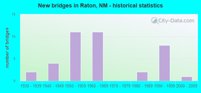
- New bridges - historical statistics
- 21930-1939
- 41940-1949
- 111950-1959
- 111960-1969
- 21980-1989
- 81990-1999
- 12000-2009

- Reconstructed bridges - Historical Statistics
- 21980-1989
- 11990-1999


- Bridge Condition - Deck
- 31.6%Good
- 42.1%Satisfactory
- 26.3%Fair

- Bridge Condition - Superstructure
- 5.3%Very good
- 21.1%Good
- 47.4%Satisfactory
- 21.1%Fair
- 5.3%Poor

- Bridge Condition - Substructure
- 5.3%Very good
- 26.3%Good
- 42.1%Satisfactory
- 21.1%Fair
- 5.3%Critical

- Bridge Condition - Channel
- 9.1%Very good
- 54.5%Good
- 36.4%Satisfactory
Find on map >> Show street view
Structure Number: 5445, Location: 0.1 MI E OF JCT LOOP-17 (Lat: 36.905567, Lng: -104.438281), Route carried "on" structure: City street 5656, Year Built: 1940, Status: Open, Structure Length: 1.52m (4.99ft), Average Daily Traffic: 106 (year 2020), Average Future Daily Traffic: 176 (year 2040), Design Load: H 15, Features Intersected: NM-72
Minimum Vertical Clearance: 30+ m (98+ ft), Kilometerpoint: 0.002, Lanes on structure: 2, Lanes under structure: 2, Owner: State Highway Agency, Approaching Roadway Width: 13.4m (44.0ft), Skew: 2 degrees, Material/Design: Steel, Design/Construction: Stringer/Multi-beam, Number Of Spans In Main Unit: 1, Length of Maximum Span: 14.9m (48.9ft), Curb or Sidewalk Widths: Left: 1.5m (4.9ft), Right: 0.0m, Curb-To-Curb Width: 13.4m (44.0ft), Out-to-Out Width: 16.0m (52.5ft)
Condition: Deck: Satisfactory, Superstructure: Satisfactory, Substructure: Satisfactory, Operating Rating: 53.5 metric tons, Method Used To Determine Operating Rating: Load Factor (LF), Inventory Rating: 24.3 metric tons, Method Used To Determine Inventory Rating: Load Factor (LF), Structural Evaluation: Equal to present minimum criteria, Deck Geometry: Superior to present desirable criteria, Underclear: High priority of corrective action, Approach Roadway Alignment: Equal to present minimum criteria, Designated Inspection Frequency: Every 24 months, Inspection Date: May 2021, Deck Structure Type: Concrete Cast-file-Place
Find on map >> Show street view
Structure Number: 5464, Location: 5.0 MI E OF JCT LOOP-17 (Lat: 36.919506, Lng: -104.369417), Route carried "on" structure: State highway 72, Year Built: 1954, Status: Open, Structure Length: 3.08m (10.10ft), Average Daily Traffic: 120 (year 2020), Truck Traffic: 21%, Average Future Daily Traffic: 103 (year 2040), Design Load: HS 15, Features Intersected: SUGARITE CREEK
Minimum Vertical Clearance: 30+ m (98+ ft), Kilometerpoint: 7.929, Lanes on structure: 2, Owner: State Highway Agency, Approaching Roadway Width: 7.3m (24.0ft), Material/Design: Concrete, Design/Construction: Channel Beam, Number Of Spans In Main Unit: 4, Length of Maximum Span: 7.6m (24.9ft), Curb-To-Curb Width: 6.8m (22.3ft), Out-to-Out Width: 7.3m (24.0ft)
Condition: Deck: Satisfactory, Superstructure: Satisfactory, Substructure: Satisfactory, Channel: Satisfactory, Operating Rating: 44.0 metric tons, Method Used To Determine Operating Rating: Load Factor (LF), Inventory Rating: 26.3 metric tons, Method Used To Determine Inventory Rating: Load Factor (LF), Structural Evaluation: Equal to present minimum criteria, Deck Geometry: Meets minimum limits, Waterway Adequacy: Equal to present desirable criteria, Approach Roadway Alignment: Equal to present minimum criteria, Length Of Structure Improvement: 3.08m (10.10ft), Designated Inspection Frequency: Every 24 months, Inspection Date: August 2021, Bridge Improvement Cost: $111,000, Roadway Improvement Cost: $11,000, Total Project Cost: $167,000 ( Estimate for 2030), Deck Structure Type: Concrete Cast-file-Place
Find on map >> Show street view
Structure Number: 6106, Location: SOUTH INTERCHANGE/RATON (Lat: 36.864736, Lng: -104.439158), Route carried "on" structure: Interstate 25, Year Built: 1959, Year Reconstructed: 1985, Status: Open, Structure Length: 5.88m (19.29ft), Average Daily Traffic: 4,071 (year 2020), Truck Traffic: 37%, Average Future Daily Traffic: 6,969 (year 2040), Design Load: HS 20+Mod, Features Intersected: US 64/LOOP-17
Minimum Vertical Clearance: 30+ m (98+ ft), Kilometerpoint: 724.366, Lanes on structure: 2, Lanes under structure: 4, Base Highway Network: Yes, Owner: State Highway Agency, Approaching Roadway Width: 11.6m (38.1ft), Skew: 14 degrees, Material/Design: Steel continuous, Design/Construction: Stringer/Multi-beam, Number Of Spans In Main Unit: 3, Length of Maximum Span: 22.3m (73.2ft), Curb-To-Curb Width: 11.6m (38.1ft), Out-to-Out Width: 12.4m (40.7ft)
Condition: Deck: Good, Superstructure: Satisfactory, Substructure: Good, Operating Rating: 50.2 metric tons, Method Used To Determine Operating Rating: Load Factor (LF), Inventory Rating: 32.4 metric tons, Method Used To Determine Inventory Rating: Load Factor (LF), Structural Evaluation: Equal to present minimum criteria, Deck Geometry: Equal to present minimum criteria, Underclear: Somewhat better than minimum adequacy, Approach Roadway Alignment: Equal to present desirable criteria, Designated Inspection Frequency: Every 24 months, Inspection Date: March 2020, Deck Structure Type: Concrete Cast-file-Place
Find on map >> Show street view
Structure Number: 6107, Location: SOUTH INTERCHANGE/RATON (Lat: 36.864944, Lng: -104.439292), Route carried "on" structure: Interstate 25, Year Built: 1959, Year Reconstructed: 1985, Status: Open, Structure Length: 5.88m (19.29ft), Average Daily Traffic: 5,468 (year 2020), Truck Traffic: 37%, Average Future Daily Traffic: 9,360 (year 2040), Design Load: HS 20+Mod, Features Intersected: US 64/LOOP-17
Minimum Vertical Clearance: 30+ m (98+ ft), Kilometerpoint: 724.366, Lanes on structure: 2, Lanes under structure: 4, Base Highway Network: Yes, Owner: State Highway Agency, Approaching Roadway Width: 11.6m (38.1ft), Skew: 14 degrees, Material/Design: Steel continuous, Design/Construction: Stringer/Multi-beam, Number Of Spans In Main Unit: 3, Length of Maximum Span: 22.3m (73.2ft), Curb-To-Curb Width: 11.6m (38.1ft), Out-to-Out Width: 12.4m (40.7ft)
Condition: Deck: Good, Superstructure: Satisfactory, Substructure: Good, Operating Rating: 50.2 metric tons, Method Used To Determine Operating Rating: Load Factor (LF), Inventory Rating: 32.4 metric tons, Method Used To Determine Inventory Rating: Load Factor (LF), Structural Evaluation: Equal to present minimum criteria, Deck Geometry: Equal to present minimum criteria, Underclear: Somewhat better than minimum adequacy, Approach Roadway Alignment: Equal to present desirable criteria, Designated Inspection Frequency: Every 24 months, Inspection Date: March 2020, Deck Structure Type: Concrete Cast-file-Place
Find on map >> Show street view
Structure Number: 6108, Location: Junction I-25/US-64/87 (Lat: 36.885017, Lng: -104.431028), Route carried "on" structure: US 64, Year Built: 1959, Status: Open, Structure Length: 7.25m (23.79ft), Average Daily Traffic: 3,198 (year 2020), Truck Traffic: 16%, Average Future Daily Traffic: 2,468 (year 2040), Design Load: HS 20, Features Intersected: I-25 NBL/SBL
Minimum Vertical Clearance: 30+ m (98+ ft), Kilometerpoint: 562.698, Lanes on structure: 2, Lanes under structure: 4, Base Highway Network: Yes, Owner: State Highway Agency, Approaching Roadway Width: 13.1m (43.0ft), Skew: 11 degrees, Material/Design: Steel continuous, Design/Construction: Stringer/Multi-beam, Number Of Spans In Main Unit: 4, Length of Maximum Span: 21.6m (70.9ft), Curb-To-Curb Width: 12.2m (40.0ft), Out-to-Out Width: 13.4m (44.0ft)
Condition: Deck: Satisfactory, Superstructure: Fair, Substructure: Fair, Operating Rating: 43.4 metric tons, Method Used To Determine Operating Rating: Load Factor (LF), Inventory Rating: 25.9 metric tons, Method Used To Determine Inventory Rating: Load Factor (LF), Structural Evaluation: Somewhat better than minimum adequacy, Deck Geometry: Better than present minimum criteria, Underclear: Somewhat better than minimum adequacy, Approach Roadway Alignment: Equal to present desirable criteria, Length Of Structure Improvement: 7.28m (23.88ft), Designated Inspection Frequency: Every 24 months, Other Special Inspection Frequency: Every 48 months, Inspection Date: September 2020, Other Special Inspection Date: October 2018, Bridge Improvement Cost: $340,000, Roadway Improvement Cost: $94,000, Total Project Cost: $570,000 ( Estimate for 2030), Deck Structure Type: Concrete Cast-file-Place, Wearing Surface/Protective System: Wearing Surface: Bituminous
Find on map >> Show street view
Structure Number: 6109, Location: Junction I-25/US-64/87 (Lat: 36.884806, Lng: -104.431086), Route carried "on" structure: US 64, Year Built: 1959, Status: Open, Structure Length: 7.25m (23.79ft), Average Daily Traffic: 3,198 (year 2020), Truck Traffic: 16%, Average Future Daily Traffic: 2,468 (year 2040), Design Load: HS 20, Features Intersected: I-25 NBL/SBL
Minimum Vertical Clearance: 30+ m (98+ ft), Kilometerpoint: 562.086, Lanes on structure: 2, Lanes under structure: 4, Base Highway Network: Yes, Owner: State Highway Agency, Approaching Roadway Width: 12.2m (40.0ft), Skew: 11 degrees, Material/Design: Steel continuous, Design/Construction: Stringer/Multi-beam, Number Of Spans In Main Unit: 4, Length of Maximum Span: 21.6m (70.9ft), Curb-To-Curb Width: 12.3m (40.4ft), Out-to-Out Width: 13.4m (44.0ft)
Condition: Deck: Satisfactory, Superstructure: Good, Substructure: Satisfactory, Operating Rating: 43.4 metric tons, Method Used To Determine Operating Rating: Load Factor (LF), Inventory Rating: 25.9 metric tons, Method Used To Determine Inventory Rating: Load Factor (LF), Structural Evaluation: Equal to present minimum criteria, Deck Geometry: Better than present minimum criteria, Underclear: Equal to present minimum criteria, Approach Roadway Alignment: Equal to present desirable criteria, Length Of Structure Improvement: 7.28m (23.88ft), Designated Inspection Frequency: Every 24 months, Other Special Inspection Frequency: Every 48 months, Inspection Date: September 2020, Other Special Inspection Date: October 2018, Bridge Improvement Cost: $340,000, Roadway Improvement Cost: $94,000, Total Project Cost: $570,000 ( Estimate for 2030), Deck Structure Type: Concrete Cast-file-Place, Wearing Surface/Protective System: Wearing Surface: Bituminous
Find on map >> Show street view
Structure Number: 611, Location: 0.5 MI N OF S RATON INTER (Lat: 36.870456, Lng: -104.436933), Route carried "on" structure: City street 5650, Year Built: 1959, Status: Open, Structure Length: 6.46m (21.19ft), Average Daily Traffic: 234 (year 2020), Truck Traffic: 16%, Average Future Daily Traffic: 439 (year 2040), Design Load: HS 20, Features Intersected: I-25 NBL/SBL
Minimum Vertical Clearance: 30+ m (98+ ft), Kilometerpoint: 0.241, Lanes on structure: 2, Lanes under structure: 4, Owner: State Highway Agency, Approaching Roadway Width: 7.3m (24.0ft), Material/Design: Concrete, Design/Construction: Stringer/Multi-beam, Number Of Spans In Main Unit: 4, Length of Maximum Span: 16.8m (55.1ft), Curb-To-Curb Width: 7.3m (24.0ft), Out-to-Out Width: 8.5m (27.9ft)
Condition: Deck: Fair, Superstructure: Satisfactory, Substructure: Satisfactory, Operating Rating: 52.1 metric tons, Method Used To Determine Operating Rating: Load Factor (LF), Inventory Rating: 31.4 metric tons, Method Used To Determine Inventory Rating: Load Factor (LF), Structural Evaluation: Equal to present minimum criteria, Deck Geometry: Somewhat better than minimum adequacy, Underclear: Equal to present minimum criteria, Approach Roadway Alignment: Equal to present minimum criteria, Length Of Structure Improvement: 6.46m (21.19ft), Designated Inspection Frequency: Every 24 months, Inspection Date: July 2020, Bridge Improvement Cost: $551,000, Roadway Improvement Cost: $55,000, Total Project Cost: $826,000 ( Estimate for 2030), Deck Structure Type: Concrete Cast-file-Place
Find on map >> Show street view
Structure Number: 6209, Location: 1.0 MI N OF JCT US-64/87 (Lat: 36.900328, Lng: -104.424864), Route carried "on" structure: State highway 72, Year Built: 1960, Status: Open, Structure Length: 6.77m (22.21ft), Average Daily Traffic: 655 (year 2020), Truck Traffic: 21%, Average Future Daily Traffic: 563 (year 2040), Design Load: HS 20, Features Intersected: I-25 NBL/SBL
Minimum Vertical Clearance: 30+ m (98+ ft), Kilometerpoint: 1.537, Lanes on structure: 2, Lanes under structure: 4, Owner: State Highway Agency, Approaching Roadway Width: 8.5m (27.9ft), Material/Design: Steel continuous, Design/Construction: Stringer/Multi-beam, Number Of Spans In Main Unit: 4, Length of Maximum Span: 17.7m (58.1ft), Curb-To-Curb Width: 8.5m (27.9ft), Out-to-Out Width: 10.1m (33.1ft)
Condition: Deck: Fair, Superstructure: Satisfactory, Substructure: Fair, Operating Rating: 50.2 metric tons, Method Used To Determine Operating Rating: Load Factor (LF), Inventory Rating: 32.4 metric tons, Method Used To Determine Inventory Rating: Load Factor (LF), Structural Evaluation: Somewhat better than minimum adequacy, Deck Geometry: Somewhat better than minimum adequacy, Underclear: Somewhat better than minimum adequacy, Approach Roadway Alignment: Equal to present desirable criteria, Length Of Structure Improvement: 6.77m (22.21ft), Designated Inspection Frequency: Every 24 months, Inspection Date: July 2020, Bridge Improvement Cost: $351,000, Roadway Improvement Cost: $35,000, Total Project Cost: $527,000 ( Estimate for 2020), Deck Structure Type: Concrete Cast-file-Place, Wearing Surface/Protective System: Wearing Surface: Bituminous
Find on map >> Show street view
Structure Number: 621, Location: 2.2 MI N OF JCT US-64/87 (Lat: 36.912503, Lng: -104.430564), Route carried "on" structure: Interstate 25, Year Built: 1960, Status: Open, Structure Length: 4.27m (14.01ft), Average Daily Traffic: 9,945 (year 2020), Truck Traffic: 51%, Average Future Daily Traffic: 14,250 (year 2040), Design Load: HS 20+Mod, Features Intersected: LINCOLN AVENUE (RATON)
Minimum Vertical Clearance: 30+ m (98+ ft), Kilometerpoint: 730.159, Lanes on structure: 2, Lanes under structure: 2, Base Highway Network: Yes, Owner: State Highway Agency, Approaching Roadway Width: 12.2m (40.0ft), Skew: 10 degrees, Material/Design: Steel continuous, Design/Construction: Stringer/Multi-beam, Number Of Spans In Main Unit: 3, Length of Maximum Span: 16.5m (54.1ft), Curb-To-Curb Width: 12.0m (39.4ft), Out-to-Out Width: 12.7m (41.7ft)
Condition: Deck: Satisfactory, Superstructure: Satisfactory, Substructure: Good, Operating Rating: 53.5 metric tons, Method Used To Determine Operating Rating: Load Factor (LF), Inventory Rating: 32.4 metric tons, Method Used To Determine Inventory Rating: Load Factor (LF), Structural Evaluation: Equal to present minimum criteria, Deck Geometry: Equal to present minimum criteria, Underclear: High priority of corrective action, Approach Roadway Alignment: Equal to present desirable criteria, Designated Inspection Frequency: Every 24 months, Inspection Date: March 2020, Deck Structure Type: Concrete Cast-file-Place, Wearing Surface/Protective System: Wearing Surface: Epoxy Overlay
Find on map >> Show street view
Structure Number: 6211, Location: 2.2 MI N OF JCT US-64/87 (Lat: 36.912342, Lng: -104.430625), Route carried "on" structure: Interstate 25, Year Built: 1960, Status: Open, Structure Length: 4.27m (14.01ft), Average Daily Traffic: 9,945 (year 2020), Truck Traffic: 51%, Average Future Daily Traffic: 14,250 (year 2040), Design Load: HS 20, Features Intersected: LINCOLN AVENUE
Minimum Vertical Clearance: 30+ m (98+ ft), Kilometerpoint: 730.243, Lanes on structure: 2, Lanes under structure: 2, Base Highway Network: Yes, Owner: State Highway Agency, Approaching Roadway Width: 12.2m (40.0ft), Skew: 10 degrees, Material/Design: Steel continuous, Design/Construction: Stringer/Multi-beam, Number Of Spans In Main Unit: 3, Length of Maximum Span: 16.5m (54.1ft), Curb-To-Curb Width: 12.0m (39.4ft), Out-to-Out Width: 12.7m (41.7ft)
Condition: Deck: Fair, Superstructure: Satisfactory, Substructure: Satisfactory, Operating Rating: 48.6 metric tons, Method Used To Determine Operating Rating: Load Factor (LF), Inventory Rating: 32.4 metric tons, Method Used To Determine Inventory Rating: Load Factor (LF), Structural Evaluation: Equal to present minimum criteria, Deck Geometry: Equal to present minimum criteria, Underclear: Somewhat better than minimum adequacy, Approach Roadway Alignment: Equal to present desirable criteria, Designated Inspection Frequency: Every 24 months, Inspection Date: March 2020, Deck Structure Type: Concrete Cast-file-Place, Wearing Surface/Protective System: Wearing Surface: Epoxy Overlay
Find on map >> Show street view
Structure Number: 6212, Location: 2.4 MI N OF JCT US-64/87 (Lat: 36.913489, Lng: -104.434575), Route carried "on" structure: City street 5656, Year Built: 1960, Status: Open, Structure Length: 6.13m (20.11ft), Average Daily Traffic: 1,776 (year 2020), Truck Traffic: 7%, Average Future Daily Traffic: 2,894 (year 2040), Design Load: HS 20, Features Intersected: I-25 NBL/SBL
Minimum Vertical Clearance: 30+ m (98+ ft), Kilometerpoint: 0.869, Lanes on structure: 2, Lanes under structure: 4, Owner: State Highway Agency, Approaching Roadway Width: 9.0m (29.5ft), Material/Design: Steel continuous, Design/Construction: Stringer/Multi-beam, Number Of Spans In Main Unit: 4, Length of Maximum Span: 17.1m (56.1ft), Curb or Sidewalk Widths: Left: 1.3m (4.3ft), Right: 1.5m (4.9ft), Curb-To-Curb Width: 9.0m (29.5ft), Out-to-Out Width: 12.2m (40.0ft)
Condition: Deck: Satisfactory, Superstructure: Fair, Substructure: Satisfactory, Operating Rating: 51.8 metric tons, Method Used To Determine Operating Rating: Load Factor (LF), Inventory Rating: 32.4 metric tons, Method Used To Determine Inventory Rating: Load Factor (LF), Structural Evaluation: Somewhat better than minimum adequacy, Deck Geometry: Somewhat better than minimum adequacy, Underclear: Somewhat better than minimum adequacy, Approach Roadway Alignment: Equal to present desirable criteria, Designated Inspection Frequency: Every 24 months, Inspection Date: March 2020, Deck Structure Type: Concrete Cast-file-Place
Find on map >> Show street view
Structure Number: 6346, Location: 0.2 MI E OF JCT LOOP-17 (Lat: 36.905700, Lng: -104.436000), Route carried "on" structure: City street 5652, Year Built: 1962, Status: Open, Structure Length: 0.98m (3.22ft), Average Daily Traffic: 1,546 (year 2020), Truck Traffic: 7%, Average Future Daily Traffic: 1,731 (year 2040), Design Load: HS 20, Features Intersected: RATON CREEK
Minimum Vertical Clearance: 30+ m (98+ ft), Kilometerpoint: 0.343, Lanes on structure: 4, Owner: State Highway Agency, Approaching Roadway Width: 20.7m (67.9ft), Skew: 1 degrees, Material/Design: Concrete continuous, Design/Construction: Culvert, Number Of Spans In Main Unit: 2, Length of Maximum Span: 4.3m (14.1ft)
Condition: Channel: Satisfactory, Culverts: Good, Operating Rating: 77.8 metric tons, Method Used To Determine Operating Rating: Load Factor (LF), Inventory Rating: 32.4 metric tons, Method Used To Determine Inventory Rating: Load Factor (LF), Structural Evaluation: Better than present minimum criteria, Waterway Adequacy: Equal to present desirable criteria, Approach Roadway Alignment: Equal to present desirable criteria, Designated Inspection Frequency: Every 48 months, Inspection Date: July 2021
Find on map >> Show street view
Structure Number: 6929, Location: 3.2 Mi S Loop-17/Raton S (Lat: 36.818025, Lng: -104.443272), Route carried "on" structure: US 64, Year Built: 1969, Status: Open, Structure Length: 9.21m (30.22ft), Average Daily Traffic: 569 (year 2020), Truck Traffic: 16%, Average Future Daily Traffic: 914 (year 2040), Design Load: HS 20, Features Intersected: I-25 NBL/SBL
Minimum Vertical Clearance: 30+ m (98+ ft), Kilometerpoint: 553.803, Lanes on structure: 2, Lanes under structure: 4, Base Highway Network: Yes, Owner: State Highway Agency, Approaching Roadway Width: 9.8m (32.2ft), Material/Design: Prestressed concrete, Design/Construction: Stringer/Multi-beam, Number Of Spans In Main Unit: 5, Length of Maximum Span: 21.9m (71.9ft), Curb-To-Curb Width: 9.3m (30.5ft), Out-to-Out Width: 10.4m (34.1ft)
Condition: Deck: Good, Superstructure: Good, Substructure: Satisfactory, Operating Rating: 53.5 metric tons, Method Used To Determine Operating Rating: Load Factor (LF), Inventory Rating: 32.4 metric tons, Method Used To Determine Inventory Rating: Load Factor (LF), Structural Evaluation: Equal to present minimum criteria, Deck Geometry: Equal to present minimum criteria, Underclear: Somewhat better than minimum adequacy, Approach Roadway Alignment: Equal to present minimum criteria, Designated Inspection Frequency: Every 24 months, Inspection Date: September 2020, Deck Structure Type: Concrete Cast-file-Place
Find on map >> Show street view
Structure Number: 7546, Location: 0.1 MI N OF SUGARITE ST (Lat: 36.907128, Lng: -104.437183), Route carried "on" structure: City street 5656, Year Built: 1933, Status: Open, Structure Length: 0.91m (2.99ft), Average Daily Traffic: 1,776 (year 2020), Truck Traffic: 7%, Average Future Daily Traffic: 2,894 (year 2040), Design Load: HS 20, Features Intersected: RATON CREEK, Facility Carried by Structure: First Street
Minimum Vertical Clearance: 30+ m (98+ ft), Kilometerpoint: 0.805, Lanes on structure: 2, Owner: City or Municipal Highway Agency, Approaching Roadway Width: 7.9m (25.9ft), Material/Design: Masonry, Design/Construction: Arch - Deck, Number Of Spans In Main Unit: 1, Length of Maximum Span: 8.5m (27.9ft), Curb or Sidewalk Widths: Left: 1.2m (3.9ft), Right: 0.0m, Curb-To-Curb Width: 9.1m (29.9ft), Out-to-Out Width: 9.8m (32.2ft)
Condition: Deck: Fair, Superstructure: Fair, Substructure: Fair, Channel: Good, Operating Rating: 59.9 metric tons, Method Used To Determine Operating Rating: Load Factor (LF), Inventory Rating: 32.4 metric tons, Method Used To Determine Inventory Rating: Load Factor (LF), Structural Evaluation: Somewhat better than minimum adequacy, Deck Geometry: Somewhat better than minimum adequacy, Waterway Adequacy: Equal to present desirable criteria, Approach Roadway Alignment: Equal to present desirable criteria, Length Of Structure Improvement: 0.91m (2.99ft), Designated Inspection Frequency: Every 24 months, Inspection Date: October 2020, Bridge Improvement Cost: $38,000, Roadway Improvement Cost: $3,000, Total Project Cost: $58,000 ( Estimate for 2030), Deck Structure Type: Other, Wearing Surface/Protective System: Wearing Surface: Bituminous
Find on map >> Show street view
Structure Number: 7733, Location: 1.2 MI N OF JCT NM-555 (Lat: 36.879383, Lng: -104.468050), Route carried "on" structure: County highway 7020, Year Built: 1940, Status: Posted for load, Structure Length: 2.68m (8.79ft), Average Daily Traffic: 109 (year 2020), Average Future Daily Traffic: 181 (year 2040), Features Intersected: UNNAMED WATERWAY, Facility Carried by Structure: 07-A020
Minimum Vertical Clearance: 30+ m (98+ ft), Kilometerpoint: 0.002, Lanes on structure: 2, Owner: County Highway Agency, Approaching Roadway Width: 4.9m (16.1ft), Material/Design: Wood or Timber, Design/Construction: Stringer/Multi-beam, Number Of Spans In Main Unit: 4, Length of Maximum Span: 7.9m (25.9ft), Curb-To-Curb Width: 6.4m (21.0ft), Out-to-Out Width: 6.8m (22.3ft)
Condition: Deck: Fair, Superstructure: Poor, Substructure: Critical, Channel: Satisfactory, Operating Rating: 14.5 metric tons, Method Used To Determine Operating Rating: No rating analysis performed, Inventory Rating: 9.1 metric tons, Method Used To Determine Inventory Rating: No rating analysis performed, Structural Evaluation: High priority of replacement, Deck Geometry: Meets minimum limits, Waterway Adequacy: Equal to present minimum criteria, Approach Roadway Alignment: Equal to present minimum criteria, Bridge Posting: Required (Relationship of Operating Rating to Maximum Legal Load: > 39.9% below), Length Of Structure Improvement: 2.68m (8.79ft), Designated Inspection Frequency: Every 24 months, Inspection Date: June 2020, Bridge Improvement Cost: $78,000, Roadway Improvement Cost: $7,000, Total Project Cost: $118,000 ( Estimate for 2020), Deck Structure Type: Wood or Timber, Wearing Surface/Protective System: Wearing Surface: Bituminous
Find on map >> Show street view
Structure Number: 8479, Location: 1.3 MI W OF JCT LOOP-17 (Lat: 36.861600, Lng: -104.461139), Route carried "on" structure: State highway 555, Year Built: 1985, Status: Open, Structure Length: 0.82m (2.69ft), Average Daily Traffic: 1,701 (year 2020), Truck Traffic: 16%, Average Future Daily Traffic: 3,182 (year 2040), Design Load: HS 20+Mod, Features Intersected: DILLON CREEK
Minimum Vertical Clearance: 30+ m (98+ ft), Kilometerpoint: 2.198, Lanes on structure: 2, Owner: State Highway Agency, Approaching Roadway Width: 9.4m (30.8ft), Skew: 3 degrees, Material/Design: Steel, Design/Construction: Culvert, Number Of Spans In Main Unit: 1, Length of Maximum Span: 8.2m (26.9ft)
Condition: Channel: Good, Culverts: Good, Operating Rating: 71.3 metric tons, Method Used To Determine Operating Rating: Load Factor (LF), Inventory Rating: 32.4 metric tons, Method Used To Determine Inventory Rating: Load Factor (LF), Structural Evaluation: Better than present minimum criteria, Waterway Adequacy: Better than present minimum criteria, Approach Roadway Alignment: Equal to present desirable criteria, Designated Inspection Frequency: Every 48 months, Inspection Date: June 2019
Find on map >> Show street view
Structure Number: 8498, Location: 0.6 MI N STEVEN ST/RATON (Lat: 36.920939, Lng: -104.420783), Route carried "on" structure: County highway 7047, Year Built: 1986, Status: Open, Structure Length: 1.16m (3.81ft), Average Daily Traffic: 109 (year 2020), Average Future Daily Traffic: 181 (year 2040), Design Load: HS 20, Features Intersected: UNNAMED WATERWAY, Facility Carried by Structure: 07-A047
Minimum Vertical Clearance: 30+ m (98+ ft), Kilometerpoint: 0.002, Lanes on structure: 2, Owner: County Highway Agency, Approaching Roadway Width: 8.2m (26.9ft), Skew: 1 degrees, Material/Design: Concrete continuous, Design/Construction: Culvert, Number Of Spans In Main Unit: 3, Length of Maximum Span: 3.7m (12.1ft)
Condition: Channel: Good, Culverts: Good, Operating Rating: 47.0 metric tons, Method Used To Determine Operating Rating: Load Factor (LF), Inventory Rating: 32.4 metric tons, Method Used To Determine Inventory Rating: Load Factor (LF), Structural Evaluation: Better than present minimum criteria, Waterway Adequacy: Equal to present desirable criteria, Approach Roadway Alignment: Equal to present desirable criteria, Designated Inspection Frequency: Every 48 months, Inspection Date: Febuary 2019
Find on map >> Show street view
Structure Number: 8838, Location: 3.7 MI N RATON S INTERCHG (Lat: 36.916019, Lng: -104.447264), Route carried "on" structure: US 17, Year Built: 1993, Year Reconstructed: 2001, Status: Open, Structure Length: 9.14m (29.99ft), Average Daily Traffic: 5,318 (year 2020), Truck Traffic: 16%, Average Future Daily Traffic: 4,104 (year 2040), Design Load: HS 20, Features Intersected: BNSF R/R, Raton Creek
Minimum Vertical Clearance: 30+ m (98+ ft), Kilometerpoint: 6.280, Lanes on structure: 2, Base Highway Network: Yes, Owner: State Highway Agency, Approaching Roadway Width: 12.2m (40.0ft), Skew: 3 degrees, Material/Design: Prestressed concrete continuous, Design/Construction: Stringer/Multi-beam, Number Of Spans In Main Unit: 16, Length of Maximum Span: 30.8m (101.0ft), Curb-To-Curb Width: 12.2m (40.0ft), Out-to-Out Width: 13.1m (43.0ft)
Condition: Deck: Satisfactory, Superstructure: Satisfactory, Substructure: Satisfactory, Channel: Very good, Operating Rating: 53.5 metric tons, Method Used To Determine Operating Rating: Load Factor (LF), Inventory Rating: 32.4 metric tons, Method Used To Determine Inventory Rating: Load Factor (LF), Structural Evaluation: Equal to present minimum criteria, Deck Geometry: Somewhat better than minimum adequacy, Underclear: Superior to present desirable criteria, Waterway Adequacy: Superior to present desirable criteria, Approach Roadway Alignment: Equal to present desirable criteria, Length Of Structure Improvement: 9.14m (29.99ft), Designated Inspection Frequency: Every 24 months, Inspection Date: October 2021, Bridge Improvement Cost: $632,000, Roadway Improvement Cost: $63,000, Total Project Cost: $948,000 ( Estimate for 2030), Deck Structure Type: Concrete Cast-file-Place, Wearing Surface/Protective System: Deck Protection: Epoxy Coated Reinforcing
Find on map >> Show street view
Structure Number: 8839, Location: NORTH RATON INTCHANGE (Lat: 36.917742, Lng: -104.446194), Route carried "on" structure: Interstate 25, Year Built: 1993, Status: Open, Structure Length: 2.56m (8.40ft), Average Daily Traffic: 8,839 (year 2020), Truck Traffic: 37%, Average Future Daily Traffic: 15,131 (year 2040), Design Load: HS 20, Features Intersected: LOOP-17
Minimum Vertical Clearance: 30+ m (98+ ft), Kilometerpoint: 731.749, Lanes on structure: 2, Lanes under structure: 2, Base Highway Network: Yes, Owner: State Highway Agency, Approaching Roadway Width: 11.9m (39.0ft), Skew: 10 degrees, Material/Design: Prestressed concrete, Design/Construction: Stringer/Multi-beam, Number Of Spans In Main Unit: 1, Length of Maximum Span: 24.7m (81.0ft), Curb-To-Curb Width: 11.8m (38.7ft), Out-to-Out Width: 12.5m (41.0ft)
Condition: Deck: Good, Superstructure: Good, Substructure: Good, Operating Rating: 73.8 metric tons, Method Used To Determine Operating Rating: Load Factor (LF), Inventory Rating: 33.8 metric tons, Method Used To Determine Inventory Rating: Load Factor (LF), Structural Evaluation: Better than present minimum criteria, Deck Geometry: Equal to present minimum criteria, Underclear: Equal to present minimum criteria, Approach Roadway Alignment: Better than present minimum criteria, Designated Inspection Frequency: Every 24 months, Inspection Date: July 2021, Deck Structure Type: Concrete Cast-file-Place, Wearing Surface/Protective System: Deck Protection: Epoxy Coated Reinforcing
Find on map >> Show street view
Structure Number: 884, Location: NORTH RATON INTERCHANGE (Lat: 36.918103, Lng: -104.445900), Route carried "on" structure: Interstate 25, Year Built: 1993, Status: Open, Structure Length: 2.56m (8.40ft), Average Daily Traffic: 9,940 (year 2020), Truck Traffic: 37%, Average Future Daily Traffic: 17,017 (year 2040), Design Load: HS 20, Features Intersected: LOOP-17
Minimum Vertical Clearance: 30+ m (98+ ft), Kilometerpoint: 731.749, Lanes on structure: 2, Lanes under structure: 2, Base Highway Network: Yes, Owner: State Highway Agency, Approaching Roadway Width: 11.9m (39.0ft), Skew: 10 degrees, Material/Design: Prestressed concrete, Design/Construction: Stringer/Multi-beam, Number Of Spans In Main Unit: 1, Length of Maximum Span: 24.7m (81.0ft), Curb-To-Curb Width: 11.6m (38.1ft), Out-to-Out Width: 12.5m (41.0ft)
Condition: Deck: Good, Superstructure: Good, Substructure: Good, Operating Rating: 73.8 metric tons, Method Used To Determine Operating Rating: Load Factor (LF), Inventory Rating: 33.8 metric tons, Method Used To Determine Inventory Rating: Load Factor (LF), Structural Evaluation: Better than present minimum criteria, Deck Geometry: Equal to present minimum criteria, Underclear: Equal to present minimum criteria, Approach Roadway Alignment: Equal to present desirable criteria, Designated Inspection Frequency: Every 24 months, Inspection Date: July 2021, Deck Structure Type: Concrete Cast-file-Place, Wearing Surface/Protective System: Deck Protection: Epoxy Coated Reinforcing
Find on map >> Show street view
Structure Number: 8971, Location: 0.5 MI S OF NM-72 (Lat: 36.894181, Lng: -104.426422), Route carried "on" structure: City street 7000, Year Built: 1995, Status: Posted for load-capacity, Structure Length: 2.74m (8.99ft), Average Daily Traffic: 106 (year 2020), Average Future Daily Traffic: 176 (year 2040), Design Load: HS 20, Features Intersected: RATON CREEK, Facility Carried by Structure: 07-Z000
Minimum Vertical Clearance: 30+ m (98+ ft), Kilometerpoint: 0.016, Lanes on structure: 2, Owner: City or Municipal Highway Agency, Approaching Roadway Width: 7.6m (24.9ft), Material/Design: Steel, Number Of Spans In Main Unit: 1, Length of Maximum Span: 27.1m (88.9ft), Curb-To-Curb Width: 8.1m (26.6ft), Out-to-Out Width: 8.3m (27.2ft)
Condition: Deck: Satisfactory, Superstructure: Fair, Substructure: Fair, Channel: Satisfactory, Operating Rating: 71.3 metric tons, Method Used To Determine Operating Rating: Load Factor (LF), Inventory Rating: 32.4 metric tons, Method Used To Determine Inventory Rating: Load Factor (LF), Structural Evaluation: Somewhat better than minimum adequacy, Deck Geometry: Somewhat better than minimum adequacy, Waterway Adequacy: Equal to present desirable criteria, Approach Roadway Alignment: Somewhat better than minimum adequacy, Designated Inspection Frequency: Every 24 months, Inspection Date: August 2021, Deck Structure Type: Other, Wearing Surface/Protective System: Wearing Surface: Bituminous
Find on map >> Show street view
Structure Number: 9352, Location: 3.2 MI E OF i-25 AT RATON (Lat: 36.868508, Lng: -104.379953), Route carried "on" structure: US 64, Year Built: 2008, Status: Open, Structure Length: 5.82m (19.09ft), Average Daily Traffic: 3,198 (year 2020), Truck Traffic: 16%, Average Future Daily Traffic: 2,468 (year 2040), Design Load: HS 25 or greater, Features Intersected: CHICO RICO CREEK
Minimum Vertical Clearance: 30+ m (98+ ft), Kilometerpoint: 567.202, Lanes on structure: 4, Base Highway Network: Yes, Owner: State Highway Agency, Approaching Roadway Width: 17.1m (56.1ft), Skew: 4 degrees, Material/Design: Prestressed concrete continuous, Design/Construction: Stringer/Multi-beam, Number Of Spans In Main Unit: 2, Length of Maximum Span: 29.6m (97.1ft), Curb-To-Curb Width: 17.6m (57.7ft), Out-to-Out Width: 18.6m (61.0ft)
Condition: Deck: Good, Superstructure: Very good, Substructure: Very good, Channel: Good, Operating Rating: 75.3 metric tons, Method Used To Determine Operating Rating: Load Factor (LF), Inventory Rating: 34.5 metric tons, Method Used To Determine Inventory Rating: Load Factor (LF), Structural Evaluation: Equal to present desirable criteria, Deck Geometry: Somewhat better than minimum adequacy, Waterway Adequacy: Equal to present desirable criteria, Approach Roadway Alignment: Equal to present desirable criteria, Designated Inspection Frequency: Every 24 months, Inspection Date: March 2020, Deck Structure Type: Concrete Cast-file-Place, Wearing Surface/Protective System: Deck Protection: Epoxy Coated Reinforcing
Find on map >> Show street view
Structure Number: 10065, Location: 0.4 MI S OF NM-72 (Lat: 36.899433, Lng: -104.432281), Route carried "on" structure: City street 5655, Year Built: 1993, Status: Open, Structure Length: 0.88m (2.89ft), Average Daily Traffic: 1,302 (year 2020), Truck Traffic: 7%, Average Future Daily Traffic: 2,122 (year 2040), Design Load: HS 20, Features Intersected: RATON CREEK
Minimum Vertical Clearance: 30+ m (98+ ft), Kilometerpoint: 0.117, Lanes on structure: 2, Owner: City or Municipal Highway Agency, Approaching Roadway Width: 10.7m (35.1ft), Skew: 3 degrees, Material/Design: Concrete continuous, Design/Construction: Culvert, Number Of Spans In Main Unit: 2, Length of Maximum Span: 4.3m (14.1ft), Curb or Sidewalk Widths: Left: 1.8m (5.9ft), Right: 0.2m (0.7ft)
Condition: Channel: Good, Culverts: Good, Operating Rating: 43.7 metric tons, Method Used To Determine Operating Rating: Load Factor (LF), Inventory Rating: 32.4 metric tons, Method Used To Determine Inventory Rating: Load Factor (LF), Structural Evaluation: Better than present minimum criteria, Waterway Adequacy: Better than present minimum criteria, Approach Roadway Alignment: Equal to present desirable criteria, Designated Inspection Frequency: Every 48 months, Inspection Date: July 2021
Find on map >> Show street view
Structure Number: 101, Location: 1.0 MI E OF LOOP-17/RATON (Lat: 36.899689, Lng: -104.407342), Route carried "on" structure: State highway 72, Year Built: 1995, Status: Open, Structure Length: 0.98m (3.22ft), Average Daily Traffic: 655 (year 2020), Truck Traffic: 21%, Average Future Daily Traffic: 563 (year 2040), Design Load: HS 20, Features Intersected: UNNAMED WATERWAY
Minimum Vertical Clearance: 30+ m (98+ ft), Kilometerpoint: 1.606, Lanes on structure: 2, Owner: State Highway Agency, Approaching Roadway Width: 11.6m (38.1ft), Material/Design: Concrete continuous, Design/Construction: Culvert, Number Of Spans In Main Unit: 3, Length of Maximum Span: 3.0m (9.8ft)
Condition: Channel: Good, Culverts: Good, Operating Rating: 58.3 metric tons, Method Used To Determine Operating Rating: Load Factor (LF), Inventory Rating: 32.4 metric tons, Method Used To Determine Inventory Rating: Load Factor (LF), Structural Evaluation: Better than present minimum criteria, Waterway Adequacy: Equal to present desirable criteria, Approach Roadway Alignment: Equal to present desirable criteria, Designated Inspection Frequency: Every 48 months, Inspection Date: August 2021
Find on map >> Show street view
Structure Number: 5445, Location: 0.1 MI E OF JCT LOOP-17 (Lat: 36.905567, Lng: -104.438281), Route carried "under" structure: City street 5652, Year Built: 1940, Structure Length: 0. m, Average Daily Traffic: 1,546 (year 2020), Truck Traffic: 7%, Features Intersected: NM-72, Facility Carried by Structure: FL-5656
Minimum Vertical Clearance: 4.32m (14.17ft), Kilometerpoint: 0.122, Lanes on structure: 2, Lanes under structure: 2, Material/Design: Steel, Design/Construction: Stringer/Multi-beam, Length of Maximum Span: 14.9m (48.9ft)
Find on map >> Show street view
Structure Number: 5492, Location: 1.7 MI N OF JCT I-25 (Lat: 36.891406, Lng: -104.441311), Route carried "under" structure: US 17, Year Built: 1934, Structure Length: 0. m, Average Daily Traffic: 8,452 (year 2020), Truck Traffic: 7%, Features Intersected: Loop-17, Facility Carried by Structure: RAILROAD
Minimum Vertical Clearance: 4.72m (15.49ft), Kilometerpoint: 3.312, Lanes under structure: 4, Material/Design: Steel, Design/Construction: Stringer/Multi-beam, Length of Maximum Span: 12.5m (41.0ft)
Find on map >> Show street view
Structure Number: 6106, Location: SOUTH INTERCHANGE/RATON (Lat: 36.864736, Lng: -104.439158), Route carried "under" structure: US 17, Year Built: 1959, Structure Length: 0. m, Average Daily Traffic: 816 (year 2020), Truck Traffic: 16%, Features Intersected: US 64/LOOP-17, Facility Carried by Structure: I-25 NBL
Minimum Vertical Clearance: 5.46m (17.91ft), Kilometerpoint: 0.080, Lanes on structure: 2, Lanes under structure: 4, Material/Design: Steel continuous, Design/Construction: Stringer/Multi-beam, Length of Maximum Span: 22.3m (73.2ft)
Find on map >> Show street view
Structure Number: 6107, Location: SOUTH INTERCHANGE/RATON (Lat: 36.864944, Lng: -104.439292), Route carried "under" structure: US 17, Year Built: 1959, Structure Length: 0. m, Average Daily Traffic: 816 (year 2020), Truck Traffic: 16%, Features Intersected: US 64/LOOP-17, Facility Carried by Structure: I-25 SBL
Minimum Vertical Clearance: 5.06m (16.60ft), Kilometerpoint: 0.080, Lanes on structure: 2, Lanes under structure: 4, Material/Design: Steel continuous, Design/Construction: Stringer/Multi-beam, Length of Maximum Span: 22.3m (73.2ft)
Find on map >> Show street view
Structure Number: 6108, Location: Junction I-25/US-64/87 (Lat: 36.885017, Lng: -104.431028), Route carried "under" structure: Interstate 25, Year Built: 1959, Structure Length: 0. m, Average Daily Traffic: 4,436 (year 2020), Truck Traffic: 51%, Features Intersected: I-25 NBL/SBL, Facility Carried by Structure: US-64 WBL
Minimum Vertical Clearance: 4.94m (16.21ft), Kilometerpoint: 726.886, Lanes on structure: 2, Lanes under structure: 4, Material/Design: Steel continuous, Design/Construction: Stringer/Multi-beam, Length of Maximum Span: 21.6m (70.9ft)
Find on map >> Show street view
Structure Number: 6109, Location: Junction I-25/US-64/87 (Lat: 36.884806, Lng: -104.431086), Route carried "under" structure: Interstate 25, Year Built: 1959, Structure Length: 0. m, Average Daily Traffic: 4,436 (year 2020), Truck Traffic: 51%, Features Intersected: I-25 NBL/SBL, Facility Carried by Structure: US-64 EBL
Minimum Vertical Clearance: 5.09m (16.70ft), Kilometerpoint: 726.886, Lanes on structure: 2, Lanes under structure: 4, Material/Design: Steel continuous, Design/Construction: Stringer/Multi-beam, Length of Maximum Span: 21.6m (70.9ft)
Find on map >> Show street view
Structure Number: 611, Location: 0.5 MI N OF S RATON INTER (Lat: 36.870456, Lng: -104.436933), Route carried "under" structure: Interstate 25, Year Built: 1959, Structure Length: 0. m, Average Daily Traffic: 4,071 (year 2020), Truck Traffic: 37%, Features Intersected: I-25 NBL/SBL, Facility Carried by Structure: FL-5650
Minimum Vertical Clearance: 5.00m (16.40ft), Kilometerpoint: 725.067, Lanes on structure: 2, Lanes under structure: 4, Material/Design: Concrete, Design/Construction: Stringer/Multi-beam, Length of Maximum Span: 16.8m (55.1ft)
Find on map >> Show street view
Structure Number: 6209, Location: 1.0 MI N OF JCT US-64/87 (Lat: 36.900328, Lng: -104.424864), Route carried "under" structure: Interstate 25, Year Built: 1960, Structure Length: 0. m, Average Daily Traffic: 8,643 (year 2020), Truck Traffic: 51%, Features Intersected: I-25 NBL/SBL, Facility Carried by Structure: NM-72
Minimum Vertical Clearance: 4.93m (16.17ft), Kilometerpoint: 728.590, Lanes on structure: 2, Lanes under structure: 4, Material/Design: Steel continuous, Design/Construction: Stringer/Multi-beam, Length of Maximum Span: 17.7m (58.1ft)
Find on map >> Show street view
Structure Number: 621, Location: 2.2 MI N OF JCT US-64/87 (Lat: 36.912503, Lng: -104.430564), Route carried "under" structure: City street 5667, Year Built: 1960, Structure Length: 0. m, Average Daily Traffic: 106 (year 2020), Features Intersected: LINCOLN AVENUE (RATON), Facility Carried by Structure: I-25 NBL
Minimum Vertical Clearance: 4.72m (15.49ft), Kilometerpoint: 0.396, Lanes on structure: 2, Lanes under structure: 2, Material/Design: Steel continuous, Design/Construction: Stringer/Multi-beam, Length of Maximum Span: 16.5m (54.1ft)
Find on map >> Show street view
Structure Number: 6211, Location: 2.2 MI N OF JCT US-64/87 (Lat: 36.912342, Lng: -104.430625), Route carried "under" structure: City street 5667, Year Built: 1960, Structure Length: 0. m, Average Daily Traffic: 106 (year 2020), Features Intersected: LINCOLN AVENUE, Facility Carried by Structure: I-25 SBL
Minimum Vertical Clearance: 5.82m (19.09ft), Kilometerpoint: 0.386, Lanes on structure: 2, Lanes under structure: 2, Material/Design: Steel continuous, Design/Construction: Stringer/Multi-beam, Length of Maximum Span: 16.5m (54.1ft)
Find on map >> Show street view
Structure Number: 6212, Location: 2.4 MI N OF JCT US-64/87 (Lat: 36.913489, Lng: -104.434575), Route carried "under" structure: Interstate 25, Year Built: 1960, Structure Length: 0. m, Average Daily Traffic: 9,945 (year 2020), Truck Traffic: 51%, Features Intersected: I-25 NBL/SBL, Facility Carried by Structure: FL-5656
Minimum Vertical Clearance: 4.88m (16.01ft), Kilometerpoint: 732.091, Lanes on structure: 2, Lanes under structure: 4, Material/Design: Steel continuous, Design/Construction: Stringer/Multi-beam, Length of Maximum Span: 17.1m (56.1ft)
Find on map >> Show street view
Structure Number: 6929, Location: 3.2 Mi S Loop-17/Raton S (Lat: 36.818025, Lng: -104.443272), Route carried "under" structure: Interstate 25, Year Built: 1969, Structure Length: 0. m, Average Daily Traffic: 7,052 (year 2020), Truck Traffic: 37%, Features Intersected: I-25 NBL/SBL, Facility Carried by Structure: US-64
Minimum Vertical Clearance: 5.05m (16.57ft), Kilometerpoint: 719.180, Lanes on structure: 2, Lanes under structure: 4, Material/Design: Prestressed concrete, Design/Construction: Stringer/Multi-beam, Length of Maximum Span: 21.9m (71.9ft)
Find on map >> Show street view
Structure Number: 7663, Location: 0.1 MI E OF JCT LOOP-17 (Lat: 36.905722, Lng: -104.438067), Route carried "under" structure: State highway 72, Year Built: 1947, Structure Length: 0. m, Average Daily Traffic: 1,546 (year 2020), Truck Traffic: 7%, Features Intersected: NM-72, Facility Carried by Structure: RAILROAD
Minimum Vertical Clearance: 4.34m (14.24ft), Kilometerpoint: 0.061, Lanes under structure: 2, Material/Design: Concrete, Design/Construction: Slab, Length of Maximum Span: 11.6m (38.1ft)
Find on map >> Show street view
Structure Number: 8839, Location: NORTH RATON INTCHANGE (Lat: 36.917742, Lng: -104.446194), Route carried "under" structure: US 17, Year Built: 1993, Structure Length: 0. m, Average Daily Traffic: 5,318 (year 2020), Truck Traffic: 16%, Features Intersected: LOOP-17, Facility Carried by Structure: I-25 SBL
Minimum Vertical Clearance: 5.24m (17.19ft), Kilometerpoint: 0.161, Lanes on structure: 2, Lanes under structure: 2, Material/Design: Prestressed concrete, Design/Construction: Stringer/Multi-beam, Length of Maximum Span: 24.7m (81.0ft)
Find on map >> Show street view
Structure Number: 884, Location: NORTH RATON INTERCHANGE (Lat: 36.918103, Lng: -104.445900), Route carried "under" structure: US 17, Year Built: 1993, Structure Length: 0. m, Average Daily Traffic: 489 (year 2020), Truck Traffic: 16%, Features Intersected: LOOP-17, Facility Carried by Structure: I-25 NBL
Minimum Vertical Clearance: 5.06m (16.60ft), Kilometerpoint: 6.598, Lanes on structure: 2, Lanes under structure: 2, Material/Design: Prestressed concrete, Design/Construction: Stringer/Multi-beam, Length of Maximum Span: 24.7m (81.0ft)