Bridge Statistics for Raymondville, Texas (TX)
Condition, Traffic, Stress, Structural Evaluation, Project Costs
- National Bridge Inventory (NBI) Statistics
- 18Number of bridges
- 200ft / 60.5mTotal length
- 81,731Total average daily traffic
- 20,919Total average daily truck traffic
- National Bridge Inventory (NBI) Registered Bridges for Raymondville
- No street view available for this location
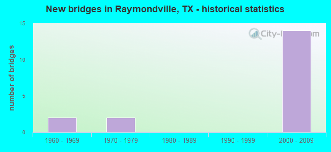
- New bridges - historical statistics
- 21960-1969
- 21970-1979
- 142000-2009


- Bridge Condition - Deck
- 83.3%Good
- 16.7%Satisfactory

- Bridge Condition - Superstructure
- 25.0%Very good
- 58.3%Good
- 16.7%Satisfactory

- Bridge Condition - Substructure
- 75.0%Good
- 25.0%Satisfactory

- Bridge Condition - Channel
- 33.3%Good
- 66.7%Satisfactory
Find on map >> Show street view
Structure Number: 212450032710005, Location: INTERSECTS SH 186 (Lat: 26.482408, Lng: -97.769292), Route carried "on" structure: US 77, Year Built: 2007, Status: Open, Structure Length: 9.21m (30.22ft), Average Daily Traffic: 5,385 (year 2019), Truck Traffic: 30%, Average Future Daily Traffic: 7,130 (year 2031), Design Load: HL 93, Features Intersected: SH 186
Minimum Vertical Clearance: 30+ m (98+ ft), Kilometerpoint: 28.996, Lanes on structure: 2, Lanes under structure: 8, Owner: State Highway Agency, Approaching Roadway Width: 11.6m (38.1ft), Material/Design: Prestressed concrete, Design/Construction: Stringer/Multi-beam, Number Of Spans In Main Unit: 3, Length of Maximum Span: 34.1m (111.9ft), Curb-To-Curb Width: 11.5m (37.7ft), Out-to-Out Width: 12.2m (40.0ft)
Condition: Deck: Good, Superstructure: Very good, Substructure: Good, Operating Rating: 54.4 metric tons, Method Used To Determine Operating Rating: Assigned ratings based on Load and Resistance Factor Design (LRFD) reported in metric tons, Inventory Rating: 32.7 metric tons, Method Used To Determine Inventory Rating: Assigned ratings based on Load and Resistance Factor Design (LRFD) reported in metric tons, Structural Evaluation: Better than present minimum criteria, Deck Geometry: Somewhat better than minimum adequacy, Underclear: Equal to present minimum criteria, Approach Roadway Alignment: Equal to present desirable criteria, Designated Inspection Frequency: Every 24 months, Inspection Date: Febuary 2021, Deck Structure Type: Concrete Precast Panels
Find on map >> Show street view
Structure Number: 212450032710022, Location: 0.75 MI N OF SH 186 (Lat: 26.493061, Lng: -97.770361), Route carried "on" structure: ServiceUS 77, Year Built: 1969, Status: Open, Structure Length: 1.52m (4.99ft), Average Daily Traffic: 1,551 (year 2019), Truck Traffic: 3%, Average Future Daily Traffic: 1,970 (year 2031), Design Load: HS 20, Features Intersected: RAYMONDVILLE DRAIN
Minimum Vertical Clearance: 30+ m (98+ ft), Kilometerpoint: 27.806, Lanes on structure: 2, Owner: State Highway Agency, Approaching Roadway Width: 11.6m (38.1ft), Material/Design: Concrete continuous, Design/Construction: Slab, Number Of Spans In Main Unit: 2, Length of Maximum Span: 7.6m (24.9ft), Curb-To-Curb Width: 12.2m (40.0ft), Out-to-Out Width: 12.9m (42.3ft)
Condition: Deck: Good, Superstructure: Good, Substructure: Satisfactory, Channel: Satisfactory, Operating Rating: 42.6 metric tons, Method Used To Determine Operating Rating: Load Factor (LF), Inventory Rating: 25.4 metric tons, Method Used To Determine Inventory Rating: Load Factor (LF), Structural Evaluation: Equal to present minimum criteria, Deck Geometry: Better than present minimum criteria, Waterway Adequacy: Equal to present minimum criteria, Approach Roadway Alignment: Equal to present desirable criteria, Designated Inspection Frequency: Every 24 months, Inspection Date: Febuary 2021, Deck Structure Type: Concrete Cast-file-Place, Wearing Surface/Protective System: Wearing Surface: Bituminous
Find on map >> Show street view
Structure Number: 212450032710023, Location: 0.75 MI N OF SH 186 (Lat: 26.492933, Lng: -97.769592), Route carried "on" structure: ServiceUS 77, Year Built: 1969, Status: Open, Structure Length: 1.52m (4.99ft), Average Daily Traffic: 1,548 (year 2018), Truck Traffic: 3%, Average Future Daily Traffic: 1,620 (year 2031), Design Load: HS 20, Features Intersected: RAYMONDVILLE DRAIN
Minimum Vertical Clearance: 30+ m (98+ ft), Kilometerpoint: 27.806, Lanes on structure: 2, Owner: State Highway Agency, Approaching Roadway Width: 11.6m (38.1ft), Material/Design: Concrete continuous, Design/Construction: Slab, Number Of Spans In Main Unit: 2, Length of Maximum Span: 7.6m (24.9ft), Curb-To-Curb Width: 12.2m (40.0ft), Out-to-Out Width: 12.9m (42.3ft)
Condition: Deck: Good, Superstructure: Good, Substructure: Good, Channel: Good, Operating Rating: 42.6 metric tons, Method Used To Determine Operating Rating: Load Factor (LF), Inventory Rating: 25.4 metric tons, Method Used To Determine Inventory Rating: Load Factor (LF), Structural Evaluation: Equal to present minimum criteria, Deck Geometry: Better than present minimum criteria, Waterway Adequacy: Equal to present minimum criteria, Approach Roadway Alignment: Equal to present desirable criteria, Designated Inspection Frequency: Every 24 months, Inspection Date: Febuary 2021, Deck Structure Type: Concrete Cast-file-Place, Wearing Surface/Protective System: Wearing Surface: Bituminous
Find on map >> Show street view
Structure Number: 21245003271005, Location: 2.19 MI S OF SH 186 (Lat: 26.452639, Lng: -97.778572), Route carried "on" structure: US 77, Year Built: 2003, Status: Open, Structure Length: 7.16m (23.49ft), Average Daily Traffic: 5,385 (year 2019), Truck Traffic: 30%, Average Future Daily Traffic: 7,130 (year 2031), Design Load: HS 25 or greater, Features Intersected: FM 490
Minimum Vertical Clearance: 30+ m (98+ ft), Kilometerpoint: 32.491, Lanes on structure: 2, Lanes under structure: 6, Owner: State Highway Agency, Approaching Roadway Width: 11.6m (38.1ft), Skew: 2 degrees, Material/Design: Prestressed concrete, Design/Construction: Stringer/Multi-beam, Number Of Spans In Main Unit: 1, Number Of Approach Spans: 2, Length of Maximum Span: 38.4m (126.0ft), Curb-To-Curb Width: 11.5m (37.7ft), Out-to-Out Width: 12.2m (40.0ft)
Condition: Deck: Good, Superstructure: Good, Substructure: Good, Operating Rating: 68.0 metric tons, Method Used To Determine Operating Rating: Assigned rating based on Load Factor Design (LFD) reported in metric tons, Inventory Rating: 40.8 metric tons, Method Used To Determine Inventory Rating: Assigned rating based on Load Factor Design (LFD) reported in metric tons, Structural Evaluation: Better than present minimum criteria, Deck Geometry: Equal to present minimum criteria, Underclear: Better than present minimum criteria, Approach Roadway Alignment: Equal to present desirable criteria, Designated Inspection Frequency: Every 24 months, Inspection Date: Febuary 2021, Deck Structure Type: Concrete Precast Panels
Find on map >> Show street view
Structure Number: 212450032710051, Location: 2.19 MI S OF SH 186 (Lat: 26.452083, Lng: -97.778506), Route carried "on" structure: US 77, Year Built: 2003, Status: Open, Structure Length: 7.16m (23.49ft), Average Daily Traffic: 5,088 (year 2019), Truck Traffic: 30%, Average Future Daily Traffic: 7,130 (year 2031), Design Load: HS 25 or greater, Features Intersected: FM 490
Minimum Vertical Clearance: 30+ m (98+ ft), Kilometerpoint: 32.483, Lanes on structure: 2, Lanes under structure: 6, Owner: State Highway Agency, Approaching Roadway Width: 11.6m (38.1ft), Skew: 2 degrees, Material/Design: Prestressed concrete, Design/Construction: Stringer/Multi-beam, Number Of Spans In Main Unit: 1, Number Of Approach Spans: 2, Length of Maximum Span: 38.4m (126.0ft), Curb-To-Curb Width: 11.5m (37.7ft), Out-to-Out Width: 12.2m (40.0ft)
Condition: Deck: Good, Superstructure: Good, Substructure: Good, Operating Rating: 68.0 metric tons, Method Used To Determine Operating Rating: Assigned rating based on Load Factor Design (LFD) reported in metric tons, Inventory Rating: 40.8 metric tons, Method Used To Determine Inventory Rating: Assigned rating based on Load Factor Design (LFD) reported in metric tons, Structural Evaluation: Better than present minimum criteria, Deck Geometry: Equal to present minimum criteria, Underclear: Better than present minimum criteria, Approach Roadway Alignment: Equal to present desirable criteria, Designated Inspection Frequency: Every 24 months, Inspection Date: Febuary 2021, Deck Structure Type: Concrete Precast Panels
Find on map >> Show street view
Structure Number: 212450032710056, Location: 1.0 MI S OF SH 186 (Lat: 26.466811, Lng: -97.770644), Route carried "on" structure: US 77, Year Built: 2003, Status: Open, Structure Length: 6.55m (21.49ft), Average Daily Traffic: 5,088 (year 2019), Truck Traffic: 30%, Average Future Daily Traffic: 7,130 (year 2031), Design Load: HS 25 or greater, Features Intersected: FM 3168
Minimum Vertical Clearance: 30+ m (98+ ft), Kilometerpoint: 30.682, Lanes on structure: 2, Lanes under structure: 6, Owner: State Highway Agency, Approaching Roadway Width: 11.6m (38.1ft), Skew: 1 degrees, Material/Design: Prestressed concrete, Design/Construction: Stringer/Multi-beam, Number Of Spans In Main Unit: 1, Number Of Approach Spans: 2, Length of Maximum Span: 36.0m (118.1ft), Curb-To-Curb Width: 11.5m (37.7ft), Out-to-Out Width: 12.2m (40.0ft)
Condition: Deck: Good, Superstructure: Good, Substructure: Good, Operating Rating: 68.0 metric tons, Method Used To Determine Operating Rating: Assigned rating based on Load Factor Design (LFD) reported in metric tons, Inventory Rating: 40.8 metric tons, Method Used To Determine Inventory Rating: Assigned rating based on Load Factor Design (LFD) reported in metric tons, Structural Evaluation: Better than present minimum criteria, Deck Geometry: Somewhat better than minimum adequacy, Underclear: Superior to present desirable criteria, Approach Roadway Alignment: Equal to present desirable criteria, Designated Inspection Frequency: Every 24 months, Inspection Date: Febuary 2021, Deck Structure Type: Concrete Precast Panels
Find on map >> Show street view
Structure Number: 212450032710057, Location: 1.0 MI S OF SH 186 (Lat: 26.467281, Lng: -97.770811), Route carried "on" structure: US 77, Year Built: 2003, Status: Open, Structure Length: 6.55m (21.49ft), Average Daily Traffic: 5,385 (year 2019), Truck Traffic: 30%, Average Future Daily Traffic: 7,130 (year 2031), Design Load: HS 25 or greater, Features Intersected: FM 3168
Minimum Vertical Clearance: 30+ m (98+ ft), Kilometerpoint: 30.687, Lanes on structure: 2, Lanes under structure: 6, Owner: State Highway Agency, Approaching Roadway Width: 11.6m (38.1ft), Skew: 1 degrees, Material/Design: Prestressed concrete, Design/Construction: Stringer/Multi-beam, Number Of Spans In Main Unit: 1, Number Of Approach Spans: 2, Length of Maximum Span: 36.0m (118.1ft), Curb-To-Curb Width: 11.5m (37.7ft), Out-to-Out Width: 12.2m (40.0ft)
Condition: Deck: Good, Superstructure: Very good, Substructure: Good, Operating Rating: 68.0 metric tons, Method Used To Determine Operating Rating: Assigned rating based on Load Factor Design (LFD) reported in metric tons, Inventory Rating: 40.8 metric tons, Method Used To Determine Inventory Rating: Assigned rating based on Load Factor Design (LFD) reported in metric tons, Structural Evaluation: Better than present minimum criteria, Deck Geometry: Somewhat better than minimum adequacy, Underclear: Superior to present desirable criteria, Approach Roadway Alignment: Equal to present desirable criteria, Designated Inspection Frequency: Every 24 months, Inspection Date: Febuary 2021, Deck Structure Type: Concrete Precast Panels
Find on map >> Show street view
Structure Number: 212450032710068, Location: 0.75 MI N OF SH 186 (Lat: 26.492931, Lng: -97.769781), Route carried "on" structure: US 77, Year Built: 2007, Status: Open, Structure Length: 2.13m (6.99ft), Average Daily Traffic: 5,088 (year 2019), Truck Traffic: 30%, Average Future Daily Traffic: 7,130 (year 2031), Design Load: HL 93, Features Intersected: RAYMONDVILLE DRAIN
Minimum Vertical Clearance: 30+ m (98+ ft), Kilometerpoint: 27.808, Lanes on structure: 2, Owner: State Highway Agency, Approaching Roadway Width: 11.6m (38.1ft), Material/Design: Prestressed concrete, Design/Construction: Stringer/Multi-beam, Number Of Spans In Main Unit: 1, Length of Maximum Span: 21.3m (69.9ft), Curb-To-Curb Width: 11.5m (37.7ft), Out-to-Out Width: 12.2m (40.0ft)
Condition: Deck: Good, Superstructure: Good, Substructure: Good, Channel: Good, Operating Rating: 54.4 metric tons, Method Used To Determine Operating Rating: Assigned ratings based on Load and Resistance Factor Design (LRFD) reported in metric tons, Inventory Rating: 32.7 metric tons, Method Used To Determine Inventory Rating: Assigned ratings based on Load and Resistance Factor Design (LRFD) reported in metric tons, Structural Evaluation: Better than present minimum criteria, Deck Geometry: Somewhat better than minimum adequacy, Waterway Adequacy: Superior to present desirable criteria, Approach Roadway Alignment: Equal to present desirable criteria, Designated Inspection Frequency: Every 24 months, Inspection Date: Febuary 2021, Deck Structure Type: Concrete Precast Panels
Find on map >> Show street view
Structure Number: 212450032710069, Location: 0.75 MI N OF SH 186 (Lat: 26.493075, Lng: -97.770156), Route carried "on" structure: US 77, Year Built: 2007, Status: Open, Structure Length: 2.13m (6.99ft), Average Daily Traffic: 5,385 (year 2019), Truck Traffic: 30%, Average Future Daily Traffic: 7,130 (year 2031), Design Load: HL 93, Features Intersected: RAYMONDVILLE DRAIN
Minimum Vertical Clearance: 30+ m (98+ ft), Kilometerpoint: 27.806, Lanes on structure: 2, Owner: State Highway Agency, Approaching Roadway Width: 11.6m (38.1ft), Material/Design: Prestressed concrete, Design/Construction: Stringer/Multi-beam, Number Of Spans In Main Unit: 1, Length of Maximum Span: 21.3m (69.9ft), Curb-To-Curb Width: 11.5m (37.7ft), Out-to-Out Width: 12.2m (40.0ft)
Condition: Deck: Good, Superstructure: Very good, Substructure: Good, Channel: Satisfactory, Operating Rating: 54.4 metric tons, Method Used To Determine Operating Rating: Assigned ratings based on Load and Resistance Factor Design (LRFD) reported in metric tons, Inventory Rating: 32.7 metric tons, Method Used To Determine Inventory Rating: Assigned ratings based on Load and Resistance Factor Design (LRFD) reported in metric tons, Structural Evaluation: Better than present minimum criteria, Deck Geometry: Somewhat better than minimum adequacy, Waterway Adequacy: Superior to present desirable criteria, Approach Roadway Alignment: Equal to present desirable criteria, Designated Inspection Frequency: Every 24 months, Inspection Date: Febuary 2021, Deck Structure Type: Concrete Precast Panels
Find on map >> Show street view
Structure Number: 21245003271007, Location: INTERSECTS SH 186 (Lat: 26.481603, Lng: -97.768947), Route carried "on" structure: US 77, Year Built: 2007, Status: Open, Structure Length: 9.21m (30.22ft), Average Daily Traffic: 5,088 (year 2019), Truck Traffic: 30%, Average Future Daily Traffic: 7,130 (year 2031), Design Load: HL 93, Features Intersected: SH 186
Minimum Vertical Clearance: 30+ m (98+ ft), Kilometerpoint: 28.996, Lanes on structure: 2, Lanes under structure: 8, Owner: State Highway Agency, Approaching Roadway Width: 11.6m (38.1ft), Material/Design: Prestressed concrete, Design/Construction: Stringer/Multi-beam, Number Of Spans In Main Unit: 3, Length of Maximum Span: 34.1m (111.9ft), Curb-To-Curb Width: 11.5m (37.7ft), Out-to-Out Width: 12.2m (40.0ft)
Condition: Deck: Good, Superstructure: Good, Substructure: Good, Operating Rating: 54.4 metric tons, Method Used To Determine Operating Rating: Assigned ratings based on Load and Resistance Factor Design (LRFD) reported in metric tons, Inventory Rating: 32.7 metric tons, Method Used To Determine Inventory Rating: Assigned ratings based on Load and Resistance Factor Design (LRFD) reported in metric tons, Structural Evaluation: Better than present minimum criteria, Deck Geometry: Somewhat better than minimum adequacy, Underclear: Equal to present minimum criteria, Approach Roadway Alignment: Equal to present desirable criteria, Designated Inspection Frequency: Every 24 months, Inspection Date: Febuary 2021, Deck Structure Type: Concrete Precast Panels
Find on map >> Show street view
Structure Number: 212450AA0170001, Location: 0.9 MI N OF JCT FM 1762 (Lat: 26.518492, Lng: -97.752842), Route carried "on" structure: County highway 315, Year Built: 1975, Status: Open, Structure Length: 3.69m (12.11ft), Average Daily Traffic: 100 (year 2019), Average Future Daily Traffic: 45 (year 2030), Design Load: H 20, Features Intersected: EAST MAIN DRAIN
Minimum Vertical Clearance: 30+ m (98+ ft), Kilometerpoint: 3.895, Lanes on structure: 2, Owner: County Highway Agency, Approaching Roadway Width: 4.9m (16.1ft), Material/Design: Concrete, Design/Construction: Stringer/Multi-beam, Number Of Spans In Main Unit: 4, Length of Maximum Span: 9.1m (29.9ft), Curb-To-Curb Width: 6.9m (22.6ft), Out-to-Out Width: 7.6m (24.9ft)
Condition: Deck: Satisfactory, Superstructure: Satisfactory, Substructure: Satisfactory, Channel: Satisfactory, Operating Rating: 68.0 metric tons, Method Used To Determine Operating Rating: Load Factor (LF), Inventory Rating: 40.8 metric tons, Method Used To Determine Inventory Rating: Load Factor (LF), Structural Evaluation: Equal to present minimum criteria, Deck Geometry: Somewhat better than minimum adequacy, Waterway Adequacy: Better than present minimum criteria, Approach Roadway Alignment: Equal to present desirable criteria, Designated Inspection Frequency: Every 24 months, Inspection Date: April 2020, Deck Structure Type: Concrete Cast-file-Place
Find on map >> Show street view
Structure Number: 212450AA0171001, Location: 1.0 MI N OF JCT FM 1762 (Lat: 26.518353, Lng: -97.736717), Route carried "on" structure: County highway 330, Year Built: 1975, Status: Open, Structure Length: 3.69m (12.11ft), Average Daily Traffic: 100 (year 2019), Average Future Daily Traffic: 20 (year 2030), Design Load: H 20, Features Intersected: EAST MAIN DRAIN
Minimum Vertical Clearance: 30+ m (98+ ft), Kilometerpoint: 1.883, Lanes on structure: 2, Owner: County Highway Agency, Approaching Roadway Width: 5.5m (18.0ft), Material/Design: Concrete, Design/Construction: Stringer/Multi-beam, Number Of Spans In Main Unit: 4, Length of Maximum Span: 9.1m (29.9ft), Curb-To-Curb Width: 6.9m (22.6ft), Out-to-Out Width: 7.6m (24.9ft)
Condition: Deck: Satisfactory, Superstructure: Satisfactory, Substructure: Satisfactory, Channel: Satisfactory, Operating Rating: 68.0 metric tons, Method Used To Determine Operating Rating: Load Factor (LF), Inventory Rating: 40.8 metric tons, Method Used To Determine Inventory Rating: Load Factor (LF), Structural Evaluation: Equal to present minimum criteria, Deck Geometry: Somewhat better than minimum adequacy, Waterway Adequacy: Better than present minimum criteria, Approach Roadway Alignment: Equal to present desirable criteria, Designated Inspection Frequency: Every 24 months, Inspection Date: April 2020, Deck Structure Type: Concrete Cast-file-Place
Find on map >> Show street view
Structure Number: 212450032710005, Location: INTERSECTS SH 186 (Lat: 26.482408, Lng: -97.769292), Route carried "under" structure: State highway 186, Year Built: 2007, Structure Length: 0. m, Average Daily Traffic: 11,300 (year 2017), Truck Traffic: 24%, Features Intersected: SH 186, Facility Carried by Structure: US 77 SB
Minimum Vertical Clearance: 5.23m (17.16ft), Kilometerpoint: 22.837, Lanes on structure: 2, Lanes under structure: 8, Material/Design: Prestressed concrete, Design/Construction: Stringer/Multi-beam, Length of Maximum Span: 34.1m (111.9ft)
Find on map >> Show street view
Structure Number: 21245003271005, Location: 2.19 MI S OF SH 186 (Lat: 26.452639, Lng: -97.778572), Route carried "under" structure: State highway 490, Year Built: 2003, Structure Length: 0. m, Average Daily Traffic: 4,660 (year 2013), Truck Traffic: 29%, Features Intersected: FM 490, Facility Carried by Structure: US 77 SB
Minimum Vertical Clearance: 4.98m (16.34ft), Kilometerpoint: 0.840, Lanes on structure: 2, Lanes under structure: 6, Material/Design: Prestressed concrete, Design/Construction: Stringer/Multi-beam, Length of Maximum Span: 38.4m (126.0ft)
Find on map >> Show street view
Structure Number: 212450032710051, Location: 2.19 MI S OF SH 186 (Lat: 26.452083, Lng: -97.778506), Route carried "under" structure: State highway 490, Year Built: 2003, Structure Length: 0. m, Average Daily Traffic: 4,660 (year 2013), Truck Traffic: 29%, Features Intersected: FM 490, Facility Carried by Structure: US 77 NB
Minimum Vertical Clearance: 5.13m (16.83ft), Kilometerpoint: 0.834, Lanes on structure: 2, Lanes under structure: 6, Material/Design: Prestressed concrete, Design/Construction: Stringer/Multi-beam, Length of Maximum Span: 38.4m (126.0ft)
Find on map >> Show street view
Structure Number: 212450032710056, Location: 1.0 MI S OF SH 186 (Lat: 26.466811, Lng: -97.770644), Route carried "under" structure: State highway 3168, Year Built: 2003, Structure Length: 0. m, Average Daily Traffic: 1,590 (year 2013), Truck Traffic: 3%, Features Intersected: FM 3168, Facility Carried by Structure: US 77 NB
Minimum Vertical Clearance: 5.56m (18.24ft), Kilometerpoint: 1.455, Lanes on structure: 2, Lanes under structure: 6, Material/Design: Prestressed concrete, Design/Construction: Stringer/Multi-beam, Length of Maximum Span: 36.0m (118.1ft)
Find on map >> Show street view
Structure Number: 212450032710057, Location: 1.0 MI S OF SH 186 (Lat: 26.467281, Lng: -97.770811), Route carried "under" structure: State highway 3168, Year Built: 2003, Structure Length: 0. m, Average Daily Traffic: 3,030 (year 2013), Truck Traffic: 3%, Features Intersected: FM 3168, Facility Carried by Structure: US 77 SB
Minimum Vertical Clearance: 5.23m (17.16ft), Kilometerpoint: 1.363, Lanes on structure: 2, Lanes under structure: 6, Material/Design: Prestressed concrete, Design/Construction: Stringer/Multi-beam, Length of Maximum Span: 36.0m (118.1ft)
Find on map >> Show street view
Structure Number: 21245003271007, Location: INTERSECTS SH 186 (Lat: 26.481603, Lng: -97.768947), Route carried "under" structure: State highway 186, Year Built: 2007, Structure Length: 0. m, Average Daily Traffic: 11,300 (year 2017), Truck Traffic: 24%, Features Intersected: SH 186, Facility Carried by Structure: US 77 NB
Minimum Vertical Clearance: 5.21m (17.09ft), Kilometerpoint: 22.888, Lanes on structure: 2, Lanes under structure: 8, Material/Design: Prestressed concrete, Design/Construction: Stringer/Multi-beam, Length of Maximum Span: 34.1m (111.9ft)