Bridge Statistics for Richmond, Rhode Island (RI)
Condition, Traffic, Stress, Structural Evaluation, Project Costs
- National Bridge Inventory (NBI) Statistics
- 18Number of bridges
- 151ft / 46.1mTotal length
- $19,105,000Total costs
- 143,671Total average daily traffic
- 12,465Total average daily truck traffic
- National Bridge Inventory (NBI) Registered Bridges for Richmond
- No street view available for this location
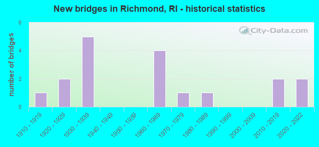
- New bridges - historical statistics
- 11910-1919
- 21920-1929
- 51930-1939
- 41960-1969
- 11970-1979
- 11980-1989
- 22010-2019
- 22020-2022

- Reconstructed bridges - Historical Statistics
- 21980-1989
- 21990-1999
- 32000-2009


- Bridge Condition - Deck
- 13.3%Very good
- 26.7%Good
- 46.7%Satisfactory
- 13.3%Fair

- Bridge Condition - Superstructure
- 17.6%Very good
- 11.8%Good
- 47.1%Satisfactory
- 11.8%Fair
- 5.9%Poor
- 5.9%Serious

- Bridge Condition - Substructure
- 17.6%Very good
- 5.9%Good
- 41.2%Satisfactory
- 17.6%Fair
- 11.8%Poor
- 5.9%Serious

- Bridge Condition - Channel
- 27.3%Good
- 54.5%Satisfactory
- 18.2%Fair
Find on map >> Show street view
Structure Number: 26, Location: 0.3 Mi N of JCT RI 2 (Lat: 41.717631, Lng: -71.493114), Route carried "on" structure: Alternate State highway 33, Year Built: 1937, Year Reconstructed: 1995, Status: Open, Structure Length: 3.78m (12.40ft), Average Daily Traffic: 10,600 (year 2021), Truck Traffic: 9%, Average Future Daily Traffic: 11,660 (year 2041), Design Load: H 20, Features Intersected: PAWTUXET RIVER
Minimum Vertical Clearance: 30+ m (98+ ft), Kilometerpoint: 8.454, Lanes on structure: 2, Owner: State Highway Agency, Approaching Roadway Width: 11.9m (39.0ft), Material/Design: Concrete, Design/Construction: Arch - Deck, Number Of Spans In Main Unit: 1, Length of Maximum Span: 36.6m (120.1ft), Curb or Sidewalk Widths: Left: 1.8m (5.9ft), Right: 1.8m (5.9ft), Curb-To-Curb Width: 11.6m (38.1ft), Out-to-Out Width: 16.6m (54.5ft)
Condition: Deck: Satisfactory, Superstructure: Satisfactory, Substructure: Satisfactory, Channel: Satisfactory, Operating Rating: 25.9 metric tons, Method Used To Determine Operating Rating: Load and Resistance Factor Rating (LRFR) rating reported by rating factor(RF) method using HL-93 loadings, Inventory Rating: 20.1 metric tons, Method Used To Determine Inventory Rating: Load and Resistance Factor Rating (LRFR) rating reported by rating factor(RF) method using HL-93 loadings, Structural Evaluation: Somewhat better than minimum adequacy, Deck Geometry: Somewhat better than minimum adequacy, Waterway Adequacy: Better than present minimum criteria, Approach Roadway Alignment: Equal to present minimum criteria, Length Of Structure Improvement: 3.78m (12.40ft), Designated Inspection Frequency: Every 24 months, Underwater Inspection Frequency: Every 48 months, Inspection Date: October 2020, Underwater Inspection Date: October 2020, Bridge Improvement Cost: $2,715,000, Roadway Improvement Cost: $271,000, Total Project Cost: $4,072,000, Deck Structure Type: Concrete Cast-file-Place, Wearing Surface/Protective System: Wearing Surface: Bituminous, Membrane: Built-up
Find on map >> Show street view
Structure Number: 27, Location: 1.5 Mi N of JCT RI 117 (Lat: 41.714411, Lng: -71.514544), Route carried "on" structure: Alternate State highway 33, Year Built: 1923, Year Reconstructed: 2007, Status: Open, Structure Length: 3.78m (12.40ft), Average Daily Traffic: 12,827 (year 2021), Truck Traffic: 6%, Average Future Daily Traffic: 14,110 (year 2041), Design Load: H 20, Features Intersected: PAWTUXET RIVER
Minimum Vertical Clearance: 30+ m (98+ ft), Kilometerpoint: 6.291, Lanes on structure: 2, Owner: State Highway Agency, Approaching Roadway Width: 10.4m (34.1ft), Skew: 3 degrees, Material/Design: Concrete, Design/Construction: Arch - Deck, Number Of Spans In Main Unit: 1, Number Of Approach Spans: 1, Length of Maximum Span: 24.4m (80.1ft), Curb or Sidewalk Widths: Left: 1.5m (4.9ft), Right: 1.5m (4.9ft), Curb-To-Curb Width: 10.5m (34.4ft), Out-to-Out Width: 15.2m (49.9ft)
Condition: Deck: Satisfactory, Superstructure: Satisfactory, Substructure: Satisfactory, Channel: Satisfactory, Operating Rating: 30.5 metric tons, Method Used To Determine Operating Rating: Load and Resistance Factor Rating (LRFR) rating reported by rating factor(RF) method using HL-93 loadings, Inventory Rating: 23.7 metric tons, Method Used To Determine Inventory Rating: Load and Resistance Factor Rating (LRFR) rating reported by rating factor(RF) method using HL-93 loadings, Structural Evaluation: Somewhat better than minimum adequacy, Deck Geometry: Meets minimum limits, Waterway Adequacy: Equal to present desirable criteria, Approach Roadway Alignment: Equal to present minimum criteria, Length Of Structure Improvement: 3.78m (12.40ft), Designated Inspection Frequency: Every 24 months, Underwater Inspection Frequency: Every 48 months, Inspection Date: December 2020, Underwater Inspection Date: December 2020, Bridge Improvement Cost: $782,000, Roadway Improvement Cost: $78,000, Total Project Cost: $1,174,000, Deck Structure Type: Concrete Cast-file-Place, Wearing Surface/Protective System: Wearing Surface: Bituminous
Find on map >> Show street view
Structure Number: 45, Location: Jct of RI 3 & RI 138 (Lat: 41.514269, Lng: -71.705000), Route carried "on" structure: State highway 3, Year Built: 1923, Year Reconstructed: 1991, Status: Open, Structure Length: 1.98m (6.50ft), Average Daily Traffic: 9,567 (year 2015), Truck Traffic: 3%, Average Future Daily Traffic: 11,481 (year 2036), Design Load: HS 20, Features Intersected: WOOD RIVER
Minimum Vertical Clearance: 30+ m (98+ ft), Kilometerpoint: 20.189, Lanes on structure: 2, Base Highway Network: Yes, Owner: State Highway Agency, Approaching Roadway Width: 7.3m (24.0ft), Material/Design: Concrete, Design/Construction: Slab, Number Of Spans In Main Unit: 3, Length of Maximum Span: 6.9m (22.6ft), Curb or Sidewalk Widths: Left: 1.5m (4.9ft), Right: 1.5m (4.9ft), Curb-To-Curb Width: 7.3m (24.0ft), Out-to-Out Width: 12.2m (40.0ft)
Condition: Deck: Good, Superstructure: Satisfactory, Substructure: Fair, Channel: Satisfactory, Operating Rating: 46.3 metric tons, Method Used To Determine Operating Rating: Load and Resistance Factor Rating (LRFR) rating reported by rating factor(RF) method using HL-93 loadings, Inventory Rating: 35.6 metric tons, Method Used To Determine Inventory Rating: Load and Resistance Factor Rating (LRFR) rating reported by rating factor(RF) method using HL-93 loadings, Structural Evaluation: Somewhat better than minimum adequacy, Deck Geometry: High priority of replacement, Waterway Adequacy: Superior to present desirable criteria, Approach Roadway Alignment: Better than present minimum criteria, Length Of Structure Improvement: 1.98m (6.50ft), Designated Inspection Frequency: Every 24 months, Inspection Date: April 2021, Bridge Improvement Cost: $178,000, Roadway Improvement Cost: $18,000, Total Project Cost: $267,000, Deck Structure Type: Other, Wearing Surface/Protective System: Wearing Surface: Bituminous, Membrane: Other, Deck Protection: Epoxy Coated Reinforcing
Find on map >> Show street view
Structure Number: 148, Location: 0.1 Mi N of JCT RI 2 (Lat: 41.445203, Lng: -71.626897), Route carried "on" structure: City street , Year Built: 1913, Status: Open, Structure Length: 1.22m (4.00ft), Average Daily Traffic: 303 (year 2014), Truck Traffic: 10%, Average Future Daily Traffic: 364 (year 2036), Features Intersected: PAWCATUCK RIVER, Facility Carried by Structure: SHERMAN AVE
Minimum Vertical Clearance: 30+ m (98+ ft), Kilometerpoint: 1.014, Lanes on structure: 2, Owner: State Highway Agency, Approaching Roadway Width: 5.8m (19.0ft), Skew: 3 degrees, Material/Design: Concrete, Design/Construction: Arch - Deck, Number Of Spans In Main Unit: 1, Length of Maximum Span: 12.2m (40.0ft), Curb-To-Curb Width: 5.9m (19.4ft), Out-to-Out Width: 6.5m (21.3ft)
Condition: Superstructure: Satisfactory, Substructure: Satisfactory, Channel: Fair, Operating Rating: 62.5 metric tons, Method Used To Determine Operating Rating: Load and Resistance Factor Rating (LRFR) rating reported by rating factor(RF) method using HL-93 loadings, Inventory Rating: 48.3 metric tons, Method Used To Determine Inventory Rating: Load and Resistance Factor Rating (LRFR) rating reported by rating factor(RF) method using HL-93 loadings, Structural Evaluation: Equal to present minimum criteria, Deck Geometry: High priority of corrective action, Waterway Adequacy: Better than present minimum criteria, Approach Roadway Alignment: Equal to present minimum criteria, Length Of Structure Improvement: 1.22m (4.00ft), Designated Inspection Frequency: Every 24 months, Underwater Inspection Frequency: Every 48 months, Inspection Date: August 2021, Underwater Inspection Date: August 2021, Bridge Improvement Cost: $161,000, Roadway Improvement Cost: $16,000, Total Project Cost: $242,000, Wearing Surface/Protective System: Wearing Surface: Bituminous
Find on map >> Show street view
Structure Number: 26, Location: 3.0 Mi W of JCT RI 112 (Lat: 41.437781, Lng: -71.721031), Route carried "on" structure: State highway 91, Year Built: 1930, Status: Open, Structure Length: 1.11m (3.64ft), Average Daily Traffic: 4,040 (year 2014), Truck Traffic: 10%, Average Future Daily Traffic: 4,848 (year 2036), Design Load: H 20, Features Intersected: MILL CANAL
Minimum Vertical Clearance: 30+ m (98+ ft), Kilometerpoint: 14.125, Lanes on structure: 2, Owner: State Highway Agency, Approaching Roadway Width: 12.1m (39.7ft), Skew: 1 degrees, Material/Design: Concrete continuous, Design/Construction: Slab, Number Of Spans In Main Unit: 2, Length of Maximum Span: 4.9m (16.1ft), Curb or Sidewalk Widths: Left: 1.4m (4.6ft), Right: 1.4m (4.6ft), Curb-To-Curb Width: 12.1m (39.7ft), Out-to-Out Width: 17.7m (58.1ft)
Condition: Deck: Satisfactory, Superstructure: Satisfactory, Substructure: Satisfactory, Channel: Satisfactory, Operating Rating: 48.9 metric tons, Method Used To Determine Operating Rating: Load and Resistance Factor Rating (LRFR) rating reported by rating factor(RF) method using HL-93 loadings, Inventory Rating: 37.9 metric tons, Method Used To Determine Inventory Rating: Load and Resistance Factor Rating (LRFR) rating reported by rating factor(RF) method using HL-93 loadings, Structural Evaluation: Equal to present minimum criteria, Deck Geometry: Somewhat better than minimum adequacy, Waterway Adequacy: Meets minimum limits, Approach Roadway Alignment: Equal to present desirable criteria, Length Of Structure Improvement: 1.04m (3.41ft), Designated Inspection Frequency: Every 24 months, Underwater Inspection Frequency: Every 48 months, Inspection Date: October 2021, Underwater Inspection Date: October 2021, Bridge Improvement Cost: $8,000, Roadway Improvement Cost: $1,000, Total Project Cost: $571,000, Deck Structure Type: Concrete Cast-file-Place, Wearing Surface/Protective System: Wearing Surface: Bituminous, Membrane: Built-up
Find on map >> Show street view
Structure Number: 269, Location: 2.0 Mi S of JCT RI 138 (Lat: 41.476717, Lng: -71.604892), Route carried "on" structure: State highway 2, Year Built: 1931, Status: Open, Structure Length: 1.22m (4.00ft), Average Daily Traffic: 5,430 (year 2021), Truck Traffic: 5%, Average Future Daily Traffic: 5,973 (year 2041), Design Load: HS 20, Features Intersected: USQUEPAUG RIVER
Minimum Vertical Clearance: 30+ m (98+ ft), Kilometerpoint: 12.247, Lanes on structure: 2, Base Highway Network: Yes, Owner: State Highway Agency, Approaching Roadway Width: 15.2m (49.9ft), Skew: 3 degrees, Material/Design: Concrete, Design/Construction: Arch - Deck, Number Of Spans In Main Unit: 1, Length of Maximum Span: 12.2m (40.0ft), Curb-To-Curb Width: 15.2m (49.9ft), Out-to-Out Width: 16.2m (53.1ft)
Condition: Superstructure: Satisfactory, Substructure: Satisfactory, Channel: Satisfactory, Operating Rating: 37.6 metric tons, Method Used To Determine Operating Rating: Load and Resistance Factor Rating (LRFR) rating reported by rating factor(RF) method using HL-93 loadings, Inventory Rating: 28.5 metric tons, Method Used To Determine Inventory Rating: Load and Resistance Factor Rating (LRFR) rating reported by rating factor(RF) method using HL-93 loadings, Structural Evaluation: Equal to present minimum criteria, Deck Geometry: Superior to present desirable criteria, Waterway Adequacy: Superior to present desirable criteria, Approach Roadway Alignment: Equal to present desirable criteria, Length Of Structure Improvement: 1.22m (4.00ft), Designated Inspection Frequency: Every 24 months, Inspection Date: October 2021, Total Project Cost: $581,000
Find on map >> Show street view
Structure Number: 27, Location: 1.8 Mi N of JCT RI 112 (Lat: 41.448167, Lng: -71.619894), Route carried "on" structure: State highway 2, Year Built: 1932, Year Reconstructed: 1996, Status: Open, Structure Length: 7.32m (24.02ft), Average Daily Traffic: 3,297 (year 2015), Truck Traffic: 10%, Average Future Daily Traffic: 3,957 (year 2036), Design Load: HS 20, Features Intersected: AMTRAK
Minimum Vertical Clearance: 30+ m (98+ ft), Kilometerpoint: 8.290, Lanes on structure: 2, Base Highway Network: Yes, Owner: State Highway Agency, Approaching Roadway Width: 12.2m (40.0ft), Skew: 5 degrees, Material/Design: Steel, Design/Construction: Girder and Floorbeam System, Number Of Spans In Main Unit: 3, Length of Maximum Span: 32.3m (106.0ft), Curb or Sidewalk Widths: Left: 1.1m (3.6ft), Right: 1.1m (3.6ft), Curb-To-Curb Width: 12.2m (40.0ft), Out-to-Out Width: 14.3m (46.9ft)
Condition: Deck: Satisfactory, Superstructure: Fair, Substructure: Satisfactory, Operating Rating: 39.2 metric tons, Method Used To Determine Operating Rating: Load and Resistance Factor Rating (LRFR) rating reported by rating factor(RF) method using HL-93 loadings, Inventory Rating: 30.5 metric tons, Method Used To Determine Inventory Rating: Load and Resistance Factor Rating (LRFR) rating reported by rating factor(RF) method using HL-93 loadings, Structural Evaluation: Somewhat better than minimum adequacy, Deck Geometry: Equal to present minimum criteria, Underclear: High priority of corrective action, Approach Roadway Alignment: Equal to present desirable criteria, Length Of Structure Improvement: 7.32m (24.02ft), Designated Inspection Frequency: Every 24 months, Critical Feature Inspection Frequency: Every 12 months, Inspection Date: November 2021, Critical Feature Inspection Date: November 2021, Bridge Improvement Cost: $1,333,000, Roadway Improvement Cost: $133,000, Total Project Cost: $2,000,000, Deck Structure Type: Concrete Cast-file-Place, Wearing Surface/Protective System: Wearing Surface: Monolithic Concrete, Membrane: Preformed Fabric, Deck Protection: Epoxy Coated Reinforcing
Find on map >> Show street view
Structure Number: 299, Location: 0.5 MI S of JCT RI 3 (Lat: 41.502800, Lng: -71.716233), Route carried "on" structure: City street , Year Built: 1930, Year Reconstructed: 1993, Status: Open, Structure Length: 1.79m (5.87ft), Average Daily Traffic: 233 (year 2021), Truck Traffic: 11%, Average Future Daily Traffic: 256 (year 2041), Design Load: HS 20, Features Intersected: WOOD RIVER, Facility Carried by Structure: NORTH SWITCH RD
Minimum Vertical Clearance: 30.45m (99.90ft), Kilometerpoint: 0.060, Lanes on structure: 2, Owner: State Highway Agency, Approaching Roadway Width: 6.8m (22.3ft), Material/Design: Wood or Timber, Design/Construction: Slab, Number Of Spans In Main Unit: 3, Length of Maximum Span: 6.6m (21.7ft), Curb-To-Curb Width: 6.8m (22.3ft), Out-to-Out Width: 7.4m (24.3ft)
Condition: Deck: Satisfactory, Superstructure: Satisfactory, Substructure: Poor, Channel: Fair, Operating Rating: 36.6 metric tons, Method Used To Determine Operating Rating: Load and Resistance Factor Rating (LRFR) rating reported by rating factor(RF) method using HL-93 loadings, Inventory Rating: 28.2 metric tons, Method Used To Determine Inventory Rating: Load and Resistance Factor Rating (LRFR) rating reported by rating factor(RF) method using HL-93 loadings, Structural Evaluation: Meets minimum limits, Deck Geometry: Meets minimum limits, Waterway Adequacy: Superior to present desirable criteria, Approach Roadway Alignment: Somewhat better than minimum adequacy, Length Of Structure Improvement: 1.77m (5.81ft), Designated Inspection Frequency: Every 24 months, Other Special Inspection Frequency: Every 12 months, Inspection Date: March 2020, Other Special Inspection Date: March 2021, Bridge Improvement Cost: $117,000, Roadway Improvement Cost: $12,000, Total Project Cost: $176,000, Deck Structure Type: Wood or Timber, Wearing Surface/Protective System: Wearing Surface: Bituminous
Find on map >> Show street view
Structure Number: 4035, Location: 1.3 Mi S of JCT RI 3 (Lat: 41.512575, Lng: -71.692056), Route carried "on" structure: Interstate 95, Year Built: 2021, Status: Open, Structure Length: 2.91m (9.55ft), Average Daily Traffic: 24,623 (year 2015), Truck Traffic: 11%, Average Future Daily Traffic: 19,548 (year 2036), Design Load: HL 93, Features Intersected: RI 138 KINGSTOWN RD
Minimum Vertical Clearance: 30+ m (98+ ft), Kilometerpoint: 11.805, Lanes on structure: 3, Lanes under structure: 2, Base Highway Network: Yes, Owner: State Highway Agency, Approaching Roadway Width: 14.9m (48.9ft), Skew: 31 degrees, Material/Design: Steel, Design/Construction: Stringer/Multi-beam, Number Of Spans In Main Unit: 1, Length of Maximum Span: 27.7m (90.9ft), Curb-To-Curb Width: 15.1m (49.5ft), Out-to-Out Width: 16.0m (52.5ft)
Condition: Deck: Very good, Superstructure: Very good, Substructure: Very good, Operating Rating: 61.9 metric tons, Method Used To Determine Operating Rating: Load and Resistance Factor Rating (LRFR) rating reported by rating factor(RF) method using HL-93 loadings, Inventory Rating: 47.6 metric tons, Method Used To Determine Inventory Rating: Load and Resistance Factor Rating (LRFR) rating reported by rating factor(RF) method using HL-93 loadings, Structural Evaluation: Equal to present desirable criteria, Deck Geometry: Meets minimum limits, Underclear: High priority of corrective action, Approach Roadway Alignment: Equal to present desirable criteria, Length Of Structure Improvement: 2.10m (6.89ft), Designated Inspection Frequency: Every 24 months, Inspection Date: December 2021, Bridge Improvement Cost: $485,000, Roadway Improvement Cost: $48,000, Total Project Cost: $649,000, Deck Structure Type: Concrete Cast-file-Place, Wearing Surface/Protective System: Wearing Surface: Bituminous, Membrane: Preformed Fabric, Deck Protection: Galvanized Reinforcing
Find on map >> Show street view
Structure Number: 4037, Location: 1.3 Mi S of JCT RI 3 (Lat: 41.512592, Lng: -71.692550), Route carried "on" structure: Interstate 95, Year Built: 2021, Status: Open, Structure Length: 2.91m (9.55ft), Average Daily Traffic: 24,623 (year 2015), Truck Traffic: 11%, Average Future Daily Traffic: 19,548 (year 2036), Design Load: HL 93, Features Intersected: RI 138 KINGSTOWN RD
Minimum Vertical Clearance: 30+ m (98+ ft), Kilometerpoint: 11.795, Lanes on structure: 3, Lanes under structure: 2, Base Highway Network: Yes, Owner: State Highway Agency, Approaching Roadway Width: 14.9m (48.9ft), Skew: 31 degrees, Material/Design: Steel, Design/Construction: Stringer/Multi-beam, Number Of Spans In Main Unit: 1, Length of Maximum Span: 27.7m (90.9ft), Curb-To-Curb Width: 15.1m (49.5ft), Out-to-Out Width: 16.0m (52.5ft)
Condition: Deck: Very good, Superstructure: Very good, Substructure: Very good, Operating Rating: 66.1 metric tons, Method Used To Determine Operating Rating: Load and Resistance Factor Rating (LRFR) rating reported by rating factor(RF) method using HL-93 loadings, Inventory Rating: 51.2 metric tons, Method Used To Determine Inventory Rating: Load and Resistance Factor Rating (LRFR) rating reported by rating factor(RF) method using HL-93 loadings, Structural Evaluation: Equal to present desirable criteria, Deck Geometry: Meets minimum limits, Underclear: Equal to present minimum criteria, Approach Roadway Alignment: Equal to present desirable criteria, Length Of Structure Improvement: 2.10m (6.89ft), Designated Inspection Frequency: Every 24 months, Inspection Date: December 2021, Bridge Improvement Cost: $485,000, Roadway Improvement Cost: $48,000, Total Project Cost: $649,000, Deck Structure Type: Concrete Cast-file-Place, Wearing Surface/Protective System: Wearing Surface: Bituminous, Membrane: Preformed Fabric, Deck Protection: Galvanized Reinforcing
Find on map >> Show street view
Structure Number: 487, Location: 0.3 Mi S of JCT RI 2 (Lat: 41.449692, Lng: -71.615753), Route carried "on" structure: City street , Year Built: 1960, Year Reconstructed: 2008, Status: Open, Structure Length: 1.46m (4.79ft), Average Daily Traffic: 100 (year 2006), Truck Traffic: 10%, Average Future Daily Traffic: 120 (year 2036), Design Load: HS 20, Features Intersected: PAWCATUCK RIVER, Facility Carried by Structure: BISCUIT CITY RD
Minimum Vertical Clearance: 4.12m (13.52ft), Kilometerpoint: 0.056, Lanes on structure: 1, Owner: Town or Township Highway Agency, Approaching Roadway Width: 4.3m (14.1ft), Material/Design: Steel, Design/Construction: Stringer/Multi-beam, Number Of Spans In Main Unit: 1, Length of Maximum Span: 13.5m (44.3ft), Curb-To-Curb Width: 4.2m (13.8ft), Out-to-Out Width: 4.9m (16.1ft)
Condition: Deck: Good, Superstructure: Good, Substructure: Fair, Channel: Good, Operating Rating: 41.8 metric tons, Method Used To Determine Operating Rating: Load and Resistance Factor Rating (LRFR) rating reported by rating factor(RF) method using HL-93 loadings, Inventory Rating: 32.1 metric tons, Method Used To Determine Inventory Rating: Load and Resistance Factor Rating (LRFR) rating reported by rating factor(RF) method using HL-93 loadings, Structural Evaluation: Somewhat better than minimum adequacy, Deck Geometry: Somewhat better than minimum adequacy, Waterway Adequacy: Superior to present desirable criteria, Approach Roadway Alignment: Meets minimum limits, Length Of Structure Improvement: 1.43m (4.69ft), Designated Inspection Frequency: Every 24 months, Inspection Date: November 2021, Bridge Improvement Cost: $1,079,000, Roadway Improvement Cost: $108,000, Total Project Cost: $1,619,000, Deck Structure Type: Wood or Timber, Wearing Surface/Protective System: Wearing Surface: Wood or Timber
Find on map >> Show street view
Structure Number: 488, Location: 0.1 Mi W of JCT RI 3 (Lat: 41.522442, Lng: -71.691750), Route carried "on" structure: City street , Year Built: 1984, Status: Posted for load, Structure Length: 2.83m (9.28ft), Average Daily Traffic: 660 (year 2021), Truck Traffic: 12%, Average Future Daily Traffic: 726 (year 2041), Design Load: HS 20, Features Intersected: WOOD RIVER, Facility Carried by Structure: SKUNK HILL RD
Minimum Vertical Clearance: 30+ m (98+ ft), Kilometerpoint: 0.929, Lanes on structure: 2, Owner: State Highway Agency, Approaching Roadway Width: 8.5m (27.9ft), Skew: 2 degrees, Material/Design: Prestressed concrete, Design/Construction: Box Beam or Girders - Multiple, Number Of Spans In Main Unit: 1, Length of Maximum Span: 27.4m (89.9ft), Curb or Sidewalk Widths: Left: 1.2m (3.9ft), Right: 1.2m (3.9ft), Curb-To-Curb Width: 8.5m (27.9ft), Out-to-Out Width: 11.6m (38.1ft)
Condition: Deck: Satisfactory, Superstructure: Fair, Substructure: Good, Channel: Good, Operating Rating: 38.2 metric tons, Method Used To Determine Operating Rating: Load and Resistance Factor (LRFR), Inventory Rating: 28.8 metric tons, Method Used To Determine Inventory Rating: Load and Resistance Factor (LRFR), Structural Evaluation: Somewhat better than minimum adequacy, Deck Geometry: Somewhat better than minimum adequacy, Waterway Adequacy: Equal to present desirable criteria, Approach Roadway Alignment: Equal to present desirable criteria, Bridge Posting: Required (Relationship of Operating Rating to Maximum Legal Load: 10.0 - 19.9% below), Length Of Structure Improvement: 2.77m (9.09ft), Designated Inspection Frequency: Every 24 months, Other Special Inspection Frequency: Every 12 months, Inspection Date: November 2021, Other Special Inspection Date: November 2021, Total Project Cost: $755,000, Wearing Surface/Protective System: Wearing Surface: Bituminous, Membrane: Preformed Fabric
Find on map >> Show street view
Structure Number: 489, Location: 0.8 Mi W of JCT RI 2 (Lat: 41.446989, Lng: -71.624967), Route carried "on" structure: City street , Year Built: 1965, Year Reconstructed: 2000, Status: Open, Structure Length: 1.16m (3.81ft), Average Daily Traffic: 202 (year 2014), Truck Traffic: 10%, Average Future Daily Traffic: 243 (year 2036), Design Load: HS 20, Features Intersected: AMTRAK, Facility Carried by Structure: KENYON SCHOOL RD
Minimum Vertical Clearance: 30+ m (98+ ft), Kilometerpoint: 0.740, Lanes on structure: 2, Owner: State Highway Agency, Approaching Roadway Width: 6.7m (22.0ft), Skew: 2 degrees, Material/Design: Prestressed concrete, Design/Construction: Box Beam or Girders - Multiple, Number Of Spans In Main Unit: 1, Length of Maximum Span: 10.9m (35.8ft), Curb or Sidewalk Widths: Left: 1.2m (3.9ft), Right: 0.0m, Curb-To-Curb Width: 6.7m (22.0ft), Out-to-Out Width: 8.8m (28.9ft)
Condition: Deck: Good, Superstructure: Good, Substructure: Satisfactory, Operating Rating: 77.1 metric tons, Method Used To Determine Operating Rating: Load and Resistance Factor Rating (LRFR) rating reported by rating factor(RF) method using HL-93 loadings, Inventory Rating: 59.6 metric tons, Method Used To Determine Inventory Rating: Load and Resistance Factor Rating (LRFR) rating reported by rating factor(RF) method using HL-93 loadings, Structural Evaluation: Equal to present minimum criteria, Deck Geometry: Meets minimum limits, Underclear: High priority of corrective action, Approach Roadway Alignment: High priority of corrective action, Length Of Structure Improvement: 1.16m (3.81ft), Designated Inspection Frequency: Every 24 months, Inspection Date: October 2021, Bridge Improvement Cost: $212,000, Roadway Improvement Cost: $21,000, Total Project Cost: $318,000, Deck Structure Type: Concrete Precast Panels, Wearing Surface/Protective System: Wearing Surface: Bituminous, Membrane: Preformed Fabric
Find on map >> Show street view
Structure Number: 542, Location: 0.3 Mi S of JCT RI 91 (Lat: 41.432867, Lng: -71.694108), Route carried "on" structure: City street , Year Built: 1964, Status: Posted for load, Structure Length: 1.95m (6.40ft), Average Daily Traffic: 1,131 (year 2021), Truck Traffic: 3%, Average Future Daily Traffic: 1,244 (year 2041), Design Load: HS 20, Features Intersected: PAWCATUCK RIVER, Facility Carried by Structure: KINGS FACTORY RD
Minimum Vertical Clearance: 30+ m (98+ ft), Kilometerpoint: 7.461, Lanes on structure: 2, Owner: State Highway Agency, Approaching Roadway Width: 9.1m (29.9ft), Material/Design: Prestressed concrete, Design/Construction: Box Beam or Girders - Multiple, Number Of Spans In Main Unit: 2, Length of Maximum Span: 9.4m (30.8ft), Curb or Sidewalk Widths: Left: 0.6m (2.0ft), Right: 0.6m (2.0ft), Curb-To-Curb Width: 7.2m (23.6ft), Out-to-Out Width: 11.2m (36.7ft)
Condition: Deck: Fair, Superstructure: Serious, Substructure: Serious, Channel: Satisfactory, Operating Rating: 12.3 metric tons, Method Used To Determine Operating Rating: Load and Resistance Factor Rating (LRFR) rating reported by rating factor(RF) method using HL-93 loadings, Inventory Rating: 9.4 metric tons, Method Used To Determine Inventory Rating: Load and Resistance Factor Rating (LRFR) rating reported by rating factor(RF) method using HL-93 loadings, Structural Evaluation: High priority of corrective action, Deck Geometry: High priority of corrective action, Waterway Adequacy: Better than present minimum criteria, Approach Roadway Alignment: Equal to present minimum criteria, Bridge Posting: Required (Relationship of Operating Rating to Maximum Legal Load: > 39.9% below), Length Of Structure Improvement: 1.95m (6.40ft), Designated Inspection Frequency: Every 24 months, Underwater Inspection Frequency: Every 48 months, Other Special Inspection Frequency: Every 6 months, Inspection Date: April 2020, Underwater Inspection Date: April 2018, Other Special Inspection Date: October 2021, Bridge Improvement Cost: $460,000, Roadway Improvement Cost: $46,000, Total Project Cost: $690,000, Deck Structure Type: Concrete Precast Panels, Wearing Surface/Protective System: Wearing Surface: Bituminous, Membrane: Built-up
Find on map >> Show street view
Structure Number: 566, Location: 2.0 Mi S of JCT RI 3 (Lat: 41.491367, Lng: -71.715361), Route carried "on" structure: City street , Year Built: 1969, Status: Open, Structure Length: 2.90m (9.51ft), Average Daily Traffic: 1,815 (year 2021), Truck Traffic: 14%, Average Future Daily Traffic: 1,997 (year 2041), Design Load: HS 20, Features Intersected: WOOD RIVER, Facility Carried by Structure: SWITCH RD
Minimum Vertical Clearance: 30+ m (98+ ft), Kilometerpoint: 6.521, Lanes on structure: 2, Owner: State Highway Agency, Approaching Roadway Width: 13.4m (44.0ft), Skew: 2 degrees, Material/Design: Prestressed concrete, Design/Construction: Stringer/Multi-beam, Number Of Spans In Main Unit: 1, Length of Maximum Span: 28.0m (91.9ft), Curb or Sidewalk Widths: Left: 0.6m (2.0ft), Right: 0.6m (2.0ft), Curb-To-Curb Width: 13.4m (44.0ft), Out-to-Out Width: 15.2m (49.9ft)
Condition: Deck: Satisfactory, Superstructure: Satisfactory, Substructure: Fair, Channel: Good, Operating Rating: 64.2 metric tons, Method Used To Determine Operating Rating: Load and Resistance Factor Rating (LRFR) rating reported by rating factor(RF) method using HL-93 loadings, Inventory Rating: 49.6 metric tons, Method Used To Determine Inventory Rating: Load and Resistance Factor Rating (LRFR) rating reported by rating factor(RF) method using HL-93 loadings, Structural Evaluation: Somewhat better than minimum adequacy, Deck Geometry: Equal to present desirable criteria, Waterway Adequacy: Equal to present desirable criteria, Approach Roadway Alignment: Equal to present minimum criteria, Length Of Structure Improvement: 2.90m (9.51ft), Designated Inspection Frequency: Every 24 months, Inspection Date: June 2021, Bridge Improvement Cost: $918,000, Roadway Improvement Cost: $92,000, Total Project Cost: $1,377,000, Deck Structure Type: Concrete Cast-file-Place, Wearing Surface/Protective System: Wearing Surface: Bituminous, Membrane: Preformed Fabric
Find on map >> Show street view
Structure Number: 5935, Location: 1.5 Mi N of JCT RI 138 (Lat: 41.537867, Lng: -71.678761), Route carried "on" structure: Interstate 95, Year Built: 2019, Status: Open, Structure Length: 2.78m (9.12ft), Average Daily Traffic: 43,029 (year 2014), Truck Traffic: 8%, Average Future Daily Traffic: 51,635 (year 2036), Design Load: HL 93, Features Intersected: ROUTE 3
Minimum Vertical Clearance: 30+ m (98+ ft), Kilometerpoint: 14.837, Lanes on structure: 4, Lanes under structure: 4, Base Highway Network: Yes, Owner: State Highway Agency, Approaching Roadway Width: 27.6m (90.6ft), Skew: 33 degrees, Material/Design: Steel, Design/Construction: Stringer/Multi-beam, Number Of Spans In Main Unit: 1, Length of Maximum Span: 25.9m (85.0ft), Curb-To-Curb Width: 27.6m (90.6ft), Out-to-Out Width: 29.6m (97.1ft)
Condition: Deck: Good, Superstructure: Very good, Substructure: Very good, Operating Rating: 55.7 metric tons, Method Used To Determine Operating Rating: Load and Resistance Factor Rating (LRFR) rating reported by rating factor(RF) method using HL-93 loadings, Inventory Rating: 43.1 metric tons, Method Used To Determine Inventory Rating: Load and Resistance Factor Rating (LRFR) rating reported by rating factor(RF) method using HL-93 loadings, Structural Evaluation: Equal to present desirable criteria, Deck Geometry: Superior to present desirable criteria, Underclear: Meets minimum limits, Approach Roadway Alignment: Equal to present desirable criteria, Length Of Structure Improvement: 2.29m (7.51ft), Designated Inspection Frequency: Every 24 months, Inspection Date: July 2021, Bridge Improvement Cost: $1,330,000, Roadway Improvement Cost: $133,000, Total Project Cost: $1,995,000, Deck Structure Type: Concrete Cast-file-Place, Wearing Surface/Protective System: Wearing Surface: Bituminous, Membrane: Other, Deck Protection: Galvanized Reinforcing
Find on map >> Show street view
Structure Number: 822, Location: 0.8 Mi S of JCT RI 91 (Lat: 41.435214, Lng: -71.698919), Route carried "on" structure: City street , Year Built: 1978, Status: Open, Structure Length: 4.97m (16.31ft), Average Daily Traffic: 1,191 (year 2021), Truck Traffic: 12%, Average Future Daily Traffic: 1,310 (year 2041), Design Load: HS 20, Features Intersected: AMTRAK, Facility Carried by Structure: KINGS FACTORY RD
Minimum Vertical Clearance: 30+ m (98+ ft), Kilometerpoint: 7.961, Lanes on structure: 2, Owner: State Highway Agency, Approaching Roadway Width: 10.4m (34.1ft), Skew: 4 degrees, Material/Design: Prestressed concrete, Design/Construction: Box Beam or Girders - Multiple, Number Of Spans In Main Unit: 3, Length of Maximum Span: 24.4m (80.1ft), Curb or Sidewalk Widths: Left: 1.5m (4.9ft), Right: 0.3m (1.0ft), Curb-To-Curb Width: 10.4m (34.1ft), Out-to-Out Width: 12.7m (41.7ft)
Condition: Deck: Fair, Superstructure: Poor, Substructure: Poor, Operating Rating: 53.8 metric tons, Method Used To Determine Operating Rating: Load and Resistance Factor Rating (LRFR) rating reported by rating factor(RF) method using HL-93 loadings, Inventory Rating: 41.5 metric tons, Method Used To Determine Inventory Rating: Load and Resistance Factor Rating (LRFR) rating reported by rating factor(RF) method using HL-93 loadings, Structural Evaluation: Meets minimum limits, Deck Geometry: Equal to present minimum criteria, Underclear: Better than present minimum criteria, Approach Roadway Alignment: Equal to present minimum criteria, Length Of Structure Improvement: 4.97m (16.31ft), Designated Inspection Frequency: Every 24 months, Other Special Inspection Frequency: Every 12 months, Inspection Date: October 2021, Other Special Inspection Date: October 2021, Bridge Improvement Cost: $1,313,000, Roadway Improvement Cost: $131,000, Total Project Cost: $1,970,000, Deck Structure Type: Concrete Precast Panels, Wearing Surface/Protective System: Wearing Surface: Bituminous, Membrane: Built-up
Find on map >> Show street view
Structure Number: 5935, Location: 1.5 Mi N of JCT RI 138 (Lat: 41.537867, Lng: -71.678761), Route carried "under" structure: State highway 3, Year Built: 2019, Structure Length: 0. m, Truck Traffic: 10%, Features Intersected: ROUTE 3, Facility Carried by Structure: I-95 NB & SB
Minimum Vertical Clearance: 4.50m (14.76ft), Kilometerpoint: 0.000, Lanes on structure: 4, Lanes under structure: 4, Material/Design: Steel, Design/Construction: Stringer/Multi-beam, Length of Maximum Span: 25.9m (85.0ft)