Bridge Statistics for Riverdale, Illinois (IL)
Condition, Traffic, Stress, Structural Evaluation, Project Costs
- National Bridge Inventory (NBI) Statistics
- 10Number of bridges
- 469ft / 143mTotal length
- $21,346,000Total costs
- 216,350Total average daily traffic
- 12,381Total average daily truck traffic
- National Bridge Inventory (NBI) Registered Bridges for Riverdale
- No street view available for this location
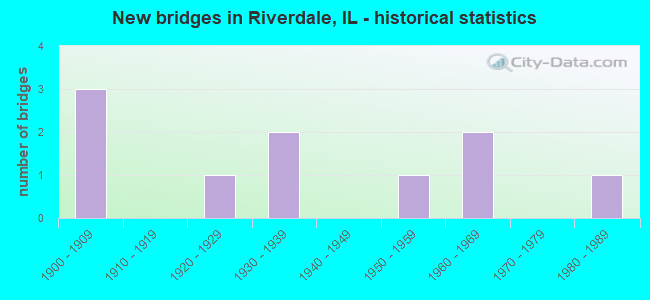
- New bridges - historical statistics
- 31900-1909
- 11920-1929
- 21930-1939
- 11950-1959
- 21960-1969
- 11980-1989
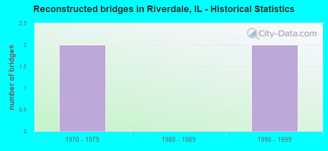
- Reconstructed bridges - Historical Statistics
- 21970-1979
- 01980-1989
- 21990-1999
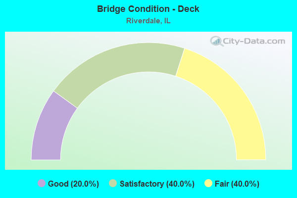
- Bridge Condition - Deck
- 20.0%Good
- 40.0%Satisfactory
- 40.0%Fair
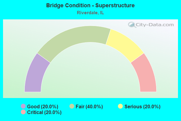
- Bridge Condition - Superstructure
- 20.0%Good
- 40.0%Fair
- 20.0%Serious
- 20.0%Critical
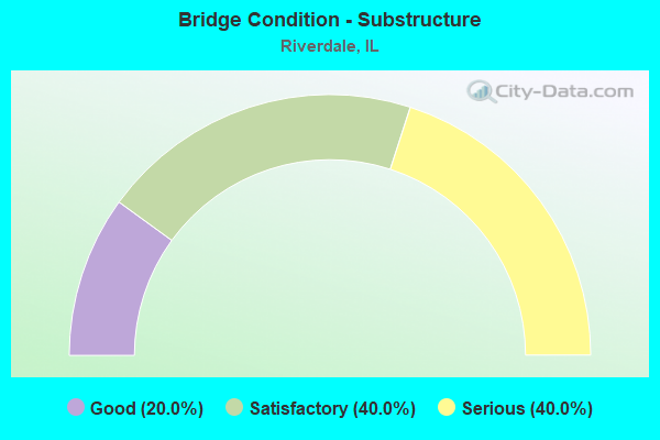
- Bridge Condition - Substructure
- 20.0%Good
- 40.0%Satisfactory
- 40.0%Serious
Find on map >> Show street view
Structure Number: 160062, Location: 0.75 M S 127TH (Lat: 41.648658, Lng: -87.661164), Route carried "on" structure: Interstate 57, Year Built: 1967, Year Reconstructed: 2002, Status: Open, Structure Length: 50.35m (165.19ft), Average Daily Traffic: 53,400 (year 2021), Truck Traffic: 6%, Average Future Daily Traffic: 71,379 (year 2032), Design Load: HS 20+Mod, Features Intersected: LITTLE CAL RIV,BROAD
Minimum Vertical Clearance: 30+ m (98+ ft), Kilometerpoint: 566.844, Lanes on structure: 3, Lanes under structure: 4, Base Highway Network: Yes, Owner: State Highway Agency, Approaching Roadway Width: 17.1m (56.1ft), Skew: 1 degrees, Material/Design: Steel continuous, Design/Construction: Stringer/Multi-beam, Number Of Spans In Main Unit: 20, Length of Maximum Span: 36.6m (120.1ft), Curb-To-Curb Width: 17.1m (56.1ft), Out-to-Out Width: 18.0m (59.1ft)
Condition: Deck: Satisfactory, Superstructure: Fair, Substructure: Satisfactory, Channel: Satisfactory, Operating Rating: 59.0 metric tons, Method Used To Determine Operating Rating: Load Factor (LF) rating reported by rating factor (RF) method using MS18 loading, Inventory Rating: 35.3 metric tons, Method Used To Determine Inventory Rating: Load Factor (LF) rating reported by rating factor (RF) method using MS18 loading, Structural Evaluation: Somewhat better than minimum adequacy, Deck Geometry: Equal to present minimum criteria, Underclear: Superior to present desirable criteria, Waterway Adequacy: Superior to present desirable criteria, Approach Roadway Alignment: Equal to present desirable criteria, Length Of Structure Improvement: 50.29m (164.99ft), Designated Inspection Frequency: Every 24 months, Inspection Date: May 2021, Bridge Improvement Cost: $7,115,000, Roadway Improvement Cost: $712,000, Total Project Cost: $10,673,000, Deck Structure Type: Concrete Cast-file-Place, Wearing Surface/Protective System: Deck Protection: Epoxy Coated Reinforcing
Find on map >> Show street view
Structure Number: 160063, Location: 0.75 M S 127TH (Lat: 41.648511, Lng: -87.661158), Route carried "on" structure: Interstate 57, Year Built: 1967, Year Reconstructed: 2003, Status: Open, Structure Length: 50.35m (165.19ft), Average Daily Traffic: 53,400 (year 2021), Truck Traffic: 6%, Average Future Daily Traffic: 71,379 (year 2032), Design Load: HS 20+Mod, Features Intersected: LITTLE CAL RIV,BROAD
Minimum Vertical Clearance: 30+ m (98+ ft), Kilometerpoint: 566.828, Lanes on structure: 3, Lanes under structure: 4, Base Highway Network: Yes, Owner: State Highway Agency, Approaching Roadway Width: 17.7m (58.1ft), Skew: 1 degrees, Material/Design: Steel continuous, Design/Construction: Stringer/Multi-beam, Number Of Spans In Main Unit: 20, Length of Maximum Span: 36.6m (120.1ft), Curb-To-Curb Width: 17.1m (56.1ft), Out-to-Out Width: 18.0m (59.1ft)
Condition: Deck: Satisfactory, Superstructure: Fair, Substructure: Satisfactory, Channel: Satisfactory, Operating Rating: 59.0 metric tons, Method Used To Determine Operating Rating: Load Factor (LF) rating reported by rating factor (RF) method using MS18 loading, Inventory Rating: 35.3 metric tons, Method Used To Determine Inventory Rating: Load Factor (LF) rating reported by rating factor (RF) method using MS18 loading, Structural Evaluation: Somewhat better than minimum adequacy, Deck Geometry: Equal to present minimum criteria, Underclear: Somewhat better than minimum adequacy, Waterway Adequacy: Superior to present desirable criteria, Approach Roadway Alignment: Equal to present desirable criteria, Length Of Structure Improvement: 50.29m (164.99ft), Designated Inspection Frequency: Every 24 months, Inspection Date: May 2021, Bridge Improvement Cost: $7,115,000, Roadway Improvement Cost: $712,000, Total Project Cost: $10,673,000, Deck Structure Type: Concrete Cast-file-Place, Wearing Surface/Protective System: Deck Protection: Epoxy Coated Reinforcing
Find on map >> Show street view
Structure Number: 160194, Location: 1.5 M N IL 83 (Lat: 41.649936, Lng: -87.641178), Route carried "on" structure: State highway 1, Year Built: 1935, Year Reconstructed: 1979, Status: Open, Structure Length: 17.10m (56.10ft), Average Daily Traffic: 15,900 (year 2021), Truck Traffic: 6%, Average Future Daily Traffic: 18,128 (year 2032), Features Intersected: RR- CSXT
Minimum Vertical Clearance: 30+ m (98+ ft), Kilometerpoint: 513.286, Lanes on structure: 4, Base Highway Network: Yes, Owner: State Highway Agency, Approaching Roadway Width: 16.5m (54.1ft), Skew: 30 degrees, Material/Design: Steel continuous, Design/Construction: Stringer/Multi-beam, Number Of Spans In Main Unit: 9, Length of Maximum Span: 19.8m (65.0ft), Curb or Sidewalk Widths: Left: 1.5m (4.9ft), Right: 1.5m (4.9ft), Curb-To-Curb Width: 16.5m (54.1ft), Out-to-Out Width: 20.7m (67.9ft)
Condition: Deck: Fair, Superstructure: Serious, Substructure: Serious, Operating Rating: 71.0 metric tons, Method Used To Determine Operating Rating: Load Factor (LF) rating reported by rating factor (RF) method using MS18 loading, Inventory Rating: 42.4 metric tons, Method Used To Determine Inventory Rating: Load Factor (LF) rating reported by rating factor (RF) method using MS18 loading, Structural Evaluation: High priority of corrective action, Deck Geometry: Meets minimum limits, Underclear: Better than present minimum criteria, Approach Roadway Alignment: Equal to present desirable criteria, Designated Inspection Frequency: Every 12 months, Inspection Date: June 2021, Deck Structure Type: Concrete Cast-file-Place, Wearing Surface/Protective System: Deck Protection: Epoxy Coated Reinforcing
Find on map >> Show street view
Structure Number: 160195, Location: 1.1 M N IL 83 (Lat: 41.641211, Lng: -87.641569), Route carried "on" structure: State highway 1, Year Built: 1927, Year Reconstructed: 1979, Status: Open, Structure Length: 22.01m (72.21ft), Average Daily Traffic: 15,900 (year 2021), Truck Traffic: 6%, Average Future Daily Traffic: 18,128 (year 2032), Features Intersected: RR - IHB
Minimum Vertical Clearance: 30+ m (98+ ft), Kilometerpoint: 512.337, Lanes on structure: 4, Base Highway Network: Yes, Owner: State Highway Agency, Approaching Roadway Width: 16.5m (54.1ft), Skew: 20 degrees, Material/Design: Steel continuous, Design/Construction: Stringer/Multi-beam, Number Of Spans In Main Unit: 12, Length of Maximum Span: 31.1m (102.0ft), Curb or Sidewalk Widths: Left: 1.5m (4.9ft), Right: 1.5m (4.9ft), Curb-To-Curb Width: 16.2m (53.1ft), Out-to-Out Width: 20.4m (66.9ft)
Condition: Deck: Fair, Superstructure: Critical, Substructure: Serious, Operating Rating: 41.1 metric tons, Method Used To Determine Operating Rating: Load Factor (LF) rating reported by rating factor (RF) method using MS18 loading, Inventory Rating: 24.6 metric tons, Method Used To Determine Inventory Rating: Load Factor (LF) rating reported by rating factor (RF) method using MS18 loading, Structural Evaluation: High priority of replacement, Deck Geometry: Meets minimum limits, Underclear: Better than present minimum criteria, Approach Roadway Alignment: Equal to present desirable criteria, Designated Inspection Frequency: Every 12 months, Other Special Inspection Frequency: Every 3 months, Inspection Date: October 2021, Other Special Inspection Date: January 2022, Deck Structure Type: Concrete Cast-file-Place, Wearing Surface/Protective System: Deck Protection: Epoxy Coated Reinforcing
Find on map >> Show street view
Structure Number: 16786, Location: 0.2 MI S. OF 138TH S (Lat: 41.640544, Lng: -87.629339), Route carried "on" structure: Other road , Year Built: 1984, Status: Open, Structure Length: 2.93m (9.61ft), Average Daily Traffic: 3,900 (year 2018), Truck Traffic: 8%, Average Future Daily Traffic: 3,811 (year 2032), Design Load: HS 20, Features Intersected: IHB RR, Facility Carried by Structure: SCHOOL ST.
Minimum Vertical Clearance: 30+ m (98+ ft), Kilometerpoint: 0.402, Lanes on structure: 2, Owner: City or Municipal Highway Agency, Approaching Roadway Width: 9.4m (30.8ft), Material/Design: Steel, Design/Construction: Stringer/Multi-beam, Number Of Spans In Main Unit: 3, Length of Maximum Span: 11.6m (38.1ft), Curb or Sidewalk Widths: Left: 1.7m (5.6ft), Right: 1.7m (5.6ft), Curb-To-Curb Width: 9.4m (30.8ft), Out-to-Out Width: 13.3m (43.6ft)
Condition: Deck: Good, Superstructure: Good, Substructure: Good, Operating Rating: 79.4 metric tons, Method Used To Determine Operating Rating: Load Factor (LF) rating reported by rating factor (RF) method using MS18 loading, Inventory Rating: 47.6 metric tons, Method Used To Determine Inventory Rating: Load Factor (LF) rating reported by rating factor (RF) method using MS18 loading, Structural Evaluation: Better than present minimum criteria, Deck Geometry: Meets minimum limits, Underclear: Somewhat better than minimum adequacy, Approach Roadway Alignment: Equal to present minimum criteria, Designated Inspection Frequency: Every 48 months, Inspection Date: September 2020, Deck Structure Type: Concrete Cast-file-Place, Wearing Surface/Protective System: Deck Protection: Epoxy Coated Reinforcing
Find on map >> Show street view
Structure Number: 160296, Location: 1 M S 127TH P4,24 (Lat: 41.649406, Lng: -87.660389), Route carried "under" structure: Other road , Year Built: 1900, Structure Length: 0. m, Average Daily Traffic: 18,900 (year 2021), Truck Traffic: 4%, Features Intersected: ASHLAND AVE, Facility Carried by Structure: B&OCT RR
Minimum Vertical Clearance: 4.29m (14.07ft), Kilometerpoint: 2.929, Lanes under structure: 4, Material/Design: Steel, Length of Maximum Span: 15.8m (51.8ft)
Find on map >> Show street view
Structure Number: 160297, Location: 1.1 M S 127TH P4,24 (Lat: 41.648839, Lng: -87.660364), Route carried "under" structure: Other road , Year Built: 1900, Structure Length: 0. m, Average Daily Traffic: 18,900 (year 2021), Truck Traffic: 4%, Features Intersected: ASHLAND AVE, Facility Carried by Structure: B&OCT RR
Minimum Vertical Clearance: 4.29m (14.07ft), Kilometerpoint: 2.993, Lanes under structure: 4, Material/Design: Steel, Length of Maximum Span: 15.2m (49.9ft)
Find on map >> Show street view
Structure Number: 160298, Location: 1.11 M S 127 P24 (Lat: 41.648414, Lng: -87.660347), Route carried "under" structure: Other road , Year Built: 1934, Structure Length: 0. m, Average Daily Traffic: 18,900 (year 2021), Truck Traffic: 4%, Features Intersected: ASHLAND AVE, Facility Carried by Structure: B&OCT RR
Minimum Vertical Clearance: 4.39m (14.40ft), Kilometerpoint: 3.042, Lanes under structure: 4, Material/Design: Steel, Length of Maximum Span: 15.2m (49.9ft)
Find on map >> Show street view
Structure Number: 160299, Location: AT 139TH ST P24 (Lat: 41.640944, Lng: -87.660069), Route carried "under" structure: Other road , Year Built: 1900, Structure Length: 0. m, Average Daily Traffic: 9,550 (year 2021), Truck Traffic: 6%, Features Intersected: ASHLAND AVE, Facility Carried by Structure: B&OCT RR
Minimum Vertical Clearance: 4.17m (13.68ft), Kilometerpoint: 3.878, Lanes under structure: 4, Material/Design: Concrete continuous, Design/Construction: Stringer/Multi-beam, Length of Maximum Span: 10.4m (34.1ft)
Find on map >> Show street view
Structure Number: 163068, Location: P4,24 (Lat: 41.644575, Lng: -87.624464), Route carried "under" structure: Other road , Year Built: 1954, Structure Length: 0. m, Average Daily Traffic: 7,600 (year 2018), Truck Traffic: 12%, Features Intersected: 138TH ST, Facility Carried by Structure: IC RR
Minimum Vertical Clearance: 4.34m (14.24ft), Kilometerpoint: 3.009, Lanes under structure: 2, Material/Design: Steel, Length of Maximum Span: 7.0m (23.0ft)