Bridge Statistics for Saline, Michigan (MI)
Condition, Traffic, Stress, Structural Evaluation, Project Costs
- National Bridge Inventory (NBI) Statistics
- 14Number of bridges
- 59ft / 18.4mTotal length
- $1,149,000Total costs
- 43,469Total average daily traffic
- 2,214Total average daily truck traffic
- 62,209Total future (year 204) average daily traffic
- National Bridge Inventory (NBI) Registered Bridges for Saline
- No street view available for this location
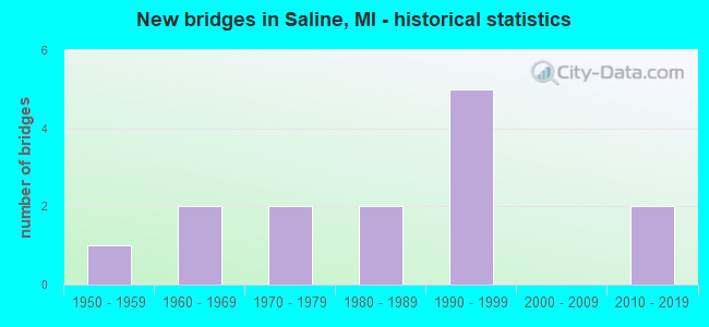
- New bridges - historical statistics
- 11950-1959
- 21960-1969
- 21970-1979
- 21980-1989
- 51990-1999
- 22010-2019

- Reconstructed bridges - Historical Statistics
- 11950-1959
- 01960-1969
- 01970-1979
- 01980-1989
- 01990-1999
- 12000-2009


- Bridge Condition - Deck
- 42.9%Good
- 42.9%Satisfactory
- 14.3%Fair

- Bridge Condition - Superstructure
- 28.6%Very good
- 42.9%Satisfactory
- 28.6%Fair

- Bridge Condition - Substructure
- 28.6%Very good
- 28.6%Good
- 14.3%Satisfactory
- 14.3%Fair
- 14.3%Poor

- Bridge Condition - Channel
- 21.4%Very good
- 7.1%Good
- 21.4%Satisfactory
- 42.9%Fair
- 7.1%Poor

- Bridge Condition - Culverts
- 14.3%Very good
- 14.3%Good
- 57.1%Satisfactory
- 14.3%Fair
Find on map >> Show street view
Structure Number: 10812, Location: IN SALINE (Lat: 42.163511, Lng: -83.789042), Route carried "on" structure: US 12, Year Built: 1967, Status: Open, Structure Length: 2.28m (7.48ft), Average Daily Traffic: 20,885 (year 2007), Truck Traffic: 5%, Average Future Daily Traffic: 26,234 (year 2018), Design Load: HS 20, Features Intersected: SALINE RIVER
Minimum Vertical Clearance: 30.48m (100.00ft), Kilometerpoint: 17.172, Lanes on structure: 3, Base Highway Network: Yes (Inventory Route: 142, Subroute: 1), Owner: State Highway Agency, Approaching Roadway Width: 13.4m (44.0ft), Skew: 2 degrees, Material/Design: Steel, Design/Construction: Stringer/Multi-beam, Number Of Spans In Main Unit: 1, Length of Maximum Span: 22.8m (74.8ft), Curb or Sidewalk Widths: Left: 1.8m (5.9ft), Right: 1.8m (5.9ft), Curb-To-Curb Width: 15.8m (51.8ft), Out-to-Out Width: 20.2m (66.3ft)
Condition: Deck: Satisfactory, Superstructure: Satisfactory, Substructure: Fair, Channel: Very good, Operating Rating: 85.9 metric tons, Method Used To Determine Operating Rating: Load Factor (LF) rating reported by rating factor (RF) method using MS18 loading, Inventory Rating: 51.5 metric tons, Method Used To Determine Inventory Rating: Load Factor (LF) rating reported by rating factor (RF) method using MS18 loading, Structural Evaluation: Somewhat better than minimum adequacy, Deck Geometry: Better than present minimum criteria, Waterway Adequacy: Equal to present desirable criteria, Approach Roadway Alignment: Equal to present desirable criteria, Length Of Structure Improvement: 2.29m (7.51ft), Designated Inspection Frequency: Every 24 months, Inspection Date: August 2020, Bridge Improvement Cost: $90,000, Roadway Improvement Cost: $6,000, Total Project Cost: $68,000, Deck Structure Type: Concrete Cast-file-Place, Wearing Surface/Protective System: Wearing Surface: Latex Concrete
Find on map >> Show street view
Structure Number: 10966, Location: SALINE TWP SEC 4 (Lat: 42.161000, Lng: -83.844350), Route carried "on" structure: County highway 8122, Year Built: 2015, Status: Open, Structure Length: 1.52m (4.99ft), Average Daily Traffic: 3,335 (year 2014), Truck Traffic: 10%, Average Future Daily Traffic: 4,320 (year 2040), Design Load: Greater than HL93, Features Intersected: SALINE RIVER, Facility Carried by Structure: AUSTIN ROAD
Minimum Vertical Clearance: 30.48m (100.00ft), Kilometerpoint: 15.566, Lanes on structure: 2, Owner: County Highway Agency, Approaching Roadway Width: 11.6m (38.1ft), Material/Design: Prestressed concrete, Design/Construction: Box Beam or Girders - Single/Spread, Number Of Spans In Main Unit: 1, Length of Maximum Span: 14.5m (47.6ft), Curb-To-Curb Width: 11.6m (38.1ft), Out-to-Out Width: 12.3m (40.4ft)
Condition: Deck: Good, Superstructure: Very good, Substructure: Very good, Channel: Very good, Operating Rating: 84.2 metric tons, Method Used To Determine Operating Rating: Load and Resistance Factor Rating (LRFR) rating reported by rating factor(RF) method using HL-93 loadings, Inventory Rating: 55.7 metric tons, Method Used To Determine Inventory Rating: Load and Resistance Factor Rating (LRFR) rating reported by rating factor(RF) method using HL-93 loadings, Structural Evaluation: Equal to present desirable criteria, Deck Geometry: Somewhat better than minimum adequacy, Waterway Adequacy: Equal to present desirable criteria, Approach Roadway Alignment: Equal to present desirable criteria, Designated Inspection Frequency: Every 24 months, Inspection Date: September 2021, Deck Structure Type: Concrete Cast-file-Place, Wearing Surface/Protective System: Wearing Surface: Monolithic Concrete, Deck Protection: Epoxy Coated Reinforcing
Find on map >> Show street view
Structure Number: 11001, Location: YORK TWP SEC 6 (Lat: 42.155703, Lng: -83.774489), Route carried "on" structure: County highway 8169, Year Built: 2019, Status: Open, Structure Length: 0.85m (2.79ft), Average Daily Traffic: 3,237 (year 2019), Truck Traffic: 5%, Average Future Daily Traffic: 3,577 (year 2039), Design Load: Greater than HL93, Features Intersected: KOCH DRAIN, Facility Carried by Structure: SALINE-MILAN ROAD
Minimum Vertical Clearance: 30.48m (100.00ft), Kilometerpoint: 8.745, Lanes on structure: 2, Owner: County Highway Agency, Approaching Roadway Width: 11.3m (37.1ft), Material/Design: Concrete, Design/Construction: Culvert, Number Of Spans In Main Unit: 1, Length of Maximum Span: 8.5m (27.9ft), Curb-To-Curb Width: 11.3m (37.1ft), Out-to-Out Width: 13.7m (44.9ft)
Condition: Channel: Fair, Culverts: Very good, Operating Rating: 66.7 metric tons, Method Used To Determine Operating Rating: Load and Resistance Factor Rating (LRFR) rating reported by rating factor(RF) method using HL-93 loadings, Inventory Rating: 52.2 metric tons, Method Used To Determine Inventory Rating: Load and Resistance Factor Rating (LRFR) rating reported by rating factor(RF) method using HL-93 loadings, Structural Evaluation: Equal to present desirable criteria, Deck Geometry: Somewhat better than minimum adequacy, Waterway Adequacy: Meets minimum limits, Approach Roadway Alignment: Equal to present minimum criteria, Length Of Structure Improvement: 1.22m (4.00ft), Designated Inspection Frequency: Every 24 months, Inspection Date: July 2021, Bridge Improvement Cost: $75,000, Roadway Improvement Cost: $20,000, Total Project Cost: $130,000, Wearing Surface/Protective System: Wearing Surface: Bituminous
Find on map >> Show street view
Structure Number: 11036, Location: CITY OF SALINE (Lat: 42.176917, Lng: -83.788136), Route carried "on" structure: City street , Year Built: 1964, Year Reconstructed: 2007, Status: Open, Structure Length: 1.05m (3.44ft), Average Daily Traffic: 2,015 (year 1997), Truck Traffic: 2%, Average Future Daily Traffic: 4,000 (year 2017), Design Load: HS 20+Mod, Features Intersected: WOOD OUTLET DRAIN, Facility Carried by Structure: SALINE WATERWORKS
Minimum Vertical Clearance: 30.48m (100.00ft), Kilometerpoint: 11.943, Lanes on structure: 3, Owner: City or Municipal Highway Agency, Approaching Roadway Width: 11.9m (39.0ft), Material/Design: Steel, Design/Construction: Culvert, Number Of Spans In Main Unit: 3, Length of Maximum Span: 3.3m (10.8ft), Curb or Sidewalk Widths: Left: 1.5m (4.9ft), Right: 0.0m, Curb-To-Curb Width: 11.9m (39.0ft), Out-to-Out Width: 22.9m (75.1ft)
Condition: Channel: Fair, Culverts: Satisfactory, Operating Rating: 97.2 metric tons, Method Used To Determine Operating Rating: Load Factor (LF) rating reported by rating factor (RF) method using MS18 loading, Inventory Rating: 97.2 metric tons, Method Used To Determine Inventory Rating: Load Factor (LF) rating reported by rating factor (RF) method using MS18 loading, Structural Evaluation: Equal to present minimum criteria, Deck Geometry: High priority of corrective action, Waterway Adequacy: Somewhat better than minimum adequacy, Approach Roadway Alignment: Equal to present desirable criteria, Length Of Structure Improvement: 2.29m (7.51ft), Designated Inspection Frequency: Every 24 months, Inspection Date: September 2021, Bridge Improvement Cost: $1,000, Roadway Improvement Cost: $6,000, Total Project Cost: $7,000
Find on map >> Show street view
Structure Number: 11037, Location: LODI TWP SEC 34 (Lat: 42.170764, Lng: -83.825353), Route carried "on" structure: County highway , Year Built: 1990, Status: Open, Structure Length: 1.82m (5.97ft), Average Daily Traffic: 940 (year 2003), Average Future Daily Traffic: 1,698 (year 2023), Design Load: HS 20, Features Intersected: SALINE RIVER, Facility Carried by Structure: DELL ROAD
Minimum Vertical Clearance: 30.48m (100.00ft), Kilometerpoint: 2.506, Lanes on structure: 2, Owner: County Highway Agency, Approaching Roadway Width: 9.1m (29.9ft), Material/Design: Prestressed concrete, Design/Construction: Box Beam or Girders - Multiple, Number Of Spans In Main Unit: 1, Length of Maximum Span: 17.0m (55.8ft), Curb-To-Curb Width: 9.1m (29.9ft), Out-to-Out Width: 9.4m (30.8ft)
Condition: Deck: Good, Superstructure: Very good, Substructure: Good, Channel: Very good, Operating Rating: 99.0 metric tons, Method Used To Determine Operating Rating: Load Factor (LF), Inventory Rating: 65.7 metric tons, Method Used To Determine Inventory Rating: Load Factor (LF), Structural Evaluation: Better than present minimum criteria, Deck Geometry: Equal to present minimum criteria, Waterway Adequacy: Equal to present desirable criteria, Approach Roadway Alignment: Equal to present desirable criteria, Length Of Structure Improvement: 1.83m (6.00ft), Designated Inspection Frequency: Every 24 months, Inspection Date: July 2021, Bridge Improvement Cost: $200,000, Roadway Improvement Cost: $40,000, Total Project Cost: $260,000, Deck Structure Type: Concrete Precast Panels, Wearing Surface/Protective System: Wearing Surface: Integral Concrete
Find on map >> Show street view
Structure Number: 11047, Location: SALINE TWP SEC 35 & 36 (Lat: 42.095253, Lng: -83.794108), Route carried "on" structure: County highway , Year Built: 1956, Year Reconstructed: 1964, Status: Open, Structure Length: 0.64m (2.10ft), Average Daily Traffic: 112 (year 2003), Average Future Daily Traffic: 150 (year 2023), Design Load: HS 20+Mod, Features Intersected: NORTH MACON CREEK, Facility Carried by Structure: MOHART
Minimum Vertical Clearance: 30.48m (100.00ft), Kilometerpoint: 1.461, Lanes on structure: 2, Owner: County Highway Agency, Approaching Roadway Width: 6.1m (20.0ft), Material/Design: Prestressed concrete, Design/Construction: Box Beam or Girders - Multiple, Number Of Spans In Main Unit: 1, Length of Maximum Span: 6.4m (21.0ft), Curb-To-Curb Width: 6.1m (20.0ft), Out-to-Out Width: 6.4m (21.0ft)
Condition: Deck: Fair, Superstructure: Fair, Substructure: Poor, Channel: Fair, Operating Rating: 65.8 metric tons, Method Used To Determine Operating Rating: Load Factor (LF), Inventory Rating: 39.4 metric tons, Method Used To Determine Inventory Rating: Load Factor (LF), Structural Evaluation: Meets minimum limits, Deck Geometry: Meets minimum limits, Waterway Adequacy: Equal to present minimum criteria, Approach Roadway Alignment: Equal to present desirable criteria, Length Of Structure Improvement: 0.85m (2.79ft), Designated Inspection Frequency: Every 24 months, Inspection Date: June 2021, Bridge Improvement Cost: $130,000, Roadway Improvement Cost: $40,000, Total Project Cost: $195,000, Deck Structure Type: Concrete Precast Panels, Wearing Surface/Protective System: Wearing Surface: Gravel
Find on map >> Show street view
Structure Number: 1105, Location: YORK TWP SEC 18 (Lat: 42.130142, Lng: -83.775436), Route carried "on" structure: County highway , Year Built: 1984, Status: Open, Structure Length: 3.23m (10.60ft), Average Daily Traffic: 128 (year 2016), Truck Traffic: 15%, Average Future Daily Traffic: 141 (year 2036), Design Load: HS 20+Mod, Features Intersected: SALINE RIVER, Facility Carried by Structure: MAPLE ROAD
Minimum Vertical Clearance: 30.48m (100.00ft), Kilometerpoint: 5.300, Lanes on structure: 2, Owner: County Highway Agency, Approaching Roadway Width: 9.1m (29.9ft), Skew: 1 degrees, Material/Design: Prestressed concrete, Design/Construction: Box Beam or Girders - Multiple, Number Of Spans In Main Unit: 2, Length of Maximum Span: 16.2m (53.1ft), Curb-To-Curb Width: 9.4m (30.8ft), Out-to-Out Width: 9.6m (31.5ft)
Condition: Deck: Good, Superstructure: Fair, Substructure: Satisfactory, Channel: Fair, Operating Rating: 49.1 metric tons, Method Used To Determine Operating Rating: Load Factor (LF), Inventory Rating: 29.4 metric tons, Method Used To Determine Inventory Rating: Load Factor (LF), Structural Evaluation: Somewhat better than minimum adequacy, Deck Geometry: Equal to present minimum criteria, Waterway Adequacy: Equal to present desirable criteria, Approach Roadway Alignment: Equal to present desirable criteria, Length Of Structure Improvement: 4.02m (13.19ft), Designated Inspection Frequency: Every 24 months, Inspection Date: April 2021, Bridge Improvement Cost: $373,000, Roadway Improvement Cost: $50,000, Total Project Cost: $450,000, Deck Structure Type: Concrete Precast Panels, Wearing Surface/Protective System: Wearing Surface: Bituminous, Membrane: Preformed Fabric, Deck Protection: Epoxy Coated Reinforcing
Find on map >> Show street view
Structure Number: 11086, Location: 0.5 MI S OF US-12 (Lat: 42.159614, Lng: -83.783486), Route carried "on" structure: City street 2071, Year Built: 1984, Status: Open, Structure Length: 1.95m (6.40ft), Average Daily Traffic: 4,952 (year 2006), Truck Traffic: 5%, Average Future Daily Traffic: 10,037 (year 2028), Design Load: HS 20+Mod, Features Intersected: SALINE RIVER, Facility Carried by Structure: MONROE STREET
Minimum Vertical Clearance: 30.48m (100.00ft), Kilometerpoint: 10.928, Lanes on structure: 2, Owner: City or Municipal Highway Agency, Approaching Roadway Width: 10.4m (34.1ft), Skew: 2 degrees, Material/Design: Prestressed concrete, Design/Construction: Box Beam or Girders - Multiple, Number Of Spans In Main Unit: 1, Length of Maximum Span: 19.5m (64.0ft), Curb or Sidewalk Widths: Left: 1.8m (5.9ft), Right: 1.8m (5.9ft), Curb-To-Curb Width: 9.1m (29.9ft), Out-to-Out Width: 13.4m (44.0ft)
Condition: Deck: Satisfactory, Superstructure: Satisfactory, Substructure: Good, Channel: Satisfactory, Operating Rating: 68.4 metric tons, Method Used To Determine Operating Rating: Load Factor (LF) rating reported by rating factor (RF) method using MS18 loading, Inventory Rating: 40.8 metric tons, Method Used To Determine Inventory Rating: Load Factor (LF) rating reported by rating factor (RF) method using MS18 loading, Structural Evaluation: Equal to present minimum criteria, Deck Geometry: Meets minimum limits, Waterway Adequacy: Equal to present desirable criteria, Approach Roadway Alignment: Equal to present desirable criteria, Length Of Structure Improvement: 1.95m (6.40ft), Designated Inspection Frequency: Every 24 months, Inspection Date: September 2021, Bridge Improvement Cost: $20,000, Roadway Improvement Cost: $8,000, Total Project Cost: $28,000, Wearing Surface/Protective System: Wearing Surface: Bituminous, Membrane: Preformed Fabric
Find on map >> Show street view
Structure Number: 11087, Location: 1.2 MI N OF US-12 (Lat: 42.182036, Lng: -83.789961), Route carried "on" structure: ServiceCity street , Year Built: 1993, Status: Open, Structure Length: 1.34m (4.40ft), Average Daily Traffic: 2,122 (year 1998), Truck Traffic: 3%, Average Future Daily Traffic: 4,000 (year 2018), Design Load: HS 20+Mod, Features Intersected: PITTSFIELD DRAIN 1, Facility Carried by Structure: WOODLAND DRIVE W
Minimum Vertical Clearance: 30.48m (100.00ft), Kilometerpoint: 0.676, Lanes on structure: 2, Owner: City or Municipal Highway Agency, Approaching Roadway Width: 7.9m (25.9ft), Material/Design: Prestressed concrete, Design/Construction: Box Beam or Girders - Multiple, Number Of Spans In Main Unit: 1, Length of Maximum Span: 13.4m (44.0ft), Curb or Sidewalk Widths: Left: 0.0m, Right: 2.9m (9.5ft), Curb-To-Curb Width: 7.9m (25.9ft), Out-to-Out Width: 11.4m (37.4ft)
Condition: Deck: Satisfactory, Superstructure: Satisfactory, Substructure: Very good, Channel: Good, Operating Rating: 97.2 metric tons, Method Used To Determine Operating Rating: Load Factor (LF) rating reported by rating factor (RF) method using MS18 loading, Inventory Rating: 62.2 metric tons, Method Used To Determine Inventory Rating: Load Factor (LF) rating reported by rating factor (RF) method using MS18 loading, Structural Evaluation: Equal to present minimum criteria, Deck Geometry: High priority of corrective action, Waterway Adequacy: Equal to present desirable criteria, Approach Roadway Alignment: Equal to present desirable criteria, Length Of Structure Improvement: 1.34m (4.40ft), Designated Inspection Frequency: Every 24 months, Inspection Date: September 2021, Bridge Improvement Cost: $5,000, Roadway Improvement Cost: $6,000, Total Project Cost: $11,000, Deck Structure Type: Concrete Cast-file-Place, Wearing Surface/Protective System: Wearing Surface: Monolithic Concrete, Deck Protection: Epoxy Coated Reinforcing
Find on map >> Show street view
Structure Number: 12995, Location: LODI TWP .25 MI E OF DELL (Lat: 42.176339, Lng: -83.821325), Route carried "on" structure: County highway , Year Built: 1990, Status: Open, Structure Length: 0.82m (2.69ft), Average Daily Traffic: 880 (year 1998), Average Future Daily Traffic: 1,290 (year 2018), Design Load: HS 20, Features Intersected: TRIB TO SALINE RIVER, Facility Carried by Structure: SALINE-WATERWORKS
Minimum Vertical Clearance: 30.48m (100.00ft), Kilometerpoint: 9.201, Lanes on structure: 2, Owner: County Highway Agency, Approaching Roadway Width: 7.0m (23.0ft), Material/Design: Steel, Design/Construction: Culvert, Number Of Spans In Main Unit: 2, Length of Maximum Span: 4.0m (13.1ft), Curb-To-Curb Width: 7.0m (23.0ft), Out-to-Out Width: 12.3m (40.4ft)
Condition: Channel: Fair, Culverts: Satisfactory, Operating Rating: 41.8 metric tons, Method Used To Determine Operating Rating: Load Factor (LF) rating reported by rating factor (RF) method using MS18 loading, Inventory Rating: 35.0 metric tons, Method Used To Determine Inventory Rating: Load Factor (LF) rating reported by rating factor (RF) method using MS18 loading, Structural Evaluation: Equal to present minimum criteria, Deck Geometry: Meets minimum limits, Waterway Adequacy: Somewhat better than minimum adequacy, Approach Roadway Alignment: Equal to present desirable criteria, Designated Inspection Frequency: Every 24 months, Inspection Date: July 2021, Wearing Surface/Protective System: Wearing Surface: Gravel
Find on map >> Show street view
Structure Number: 12996, Location: LODI TWP W OF NOBLE RD (Lat: 42.191089, Lng: -83.811464), Route carried "on" structure: County highway , Year Built: 1990, Status: Open, Structure Length: 0.78m (2.56ft), Average Daily Traffic: 631 (year 2002), Truck Traffic: 2%, Average Future Daily Traffic: 1,140 (year 2022), Design Load: HS 20, Features Intersected: TRIB TO SALINE RIVER, Facility Carried by Structure: WEBER ROAD
Minimum Vertical Clearance: 30.48m (100.00ft), Kilometerpoint: 8.573, Lanes on structure: 2, Owner: County Highway Agency, Approaching Roadway Width: 7.0m (23.0ft), Material/Design: Steel, Design/Construction: Culvert, Number Of Spans In Main Unit: 2, Length of Maximum Span: 3.6m (11.8ft), Curb-To-Curb Width: 7.0m (23.0ft), Out-to-Out Width: 18.3m (60.0ft)
Condition: Channel: Poor, Culverts: Fair, Operating Rating: 97.2 metric tons, Method Used To Determine Operating Rating: Load Factor (LF) rating reported by rating factor (RF) method using MS18 loading, Inventory Rating: 97.2 metric tons, Method Used To Determine Inventory Rating: Load Factor (LF) rating reported by rating factor (RF) method using MS18 loading, Structural Evaluation: Somewhat better than minimum adequacy, Deck Geometry: Meets minimum limits, Waterway Adequacy: High priority of corrective action, Approach Roadway Alignment: Equal to present desirable criteria, Designated Inspection Frequency: Every 24 months, Inspection Date: July 2021, Wearing Surface/Protective System: Wearing Surface: Bituminous
Find on map >> Show street view
Structure Number: 12997, Location: LODI TWP 500' N BETHEL CH (Lat: 42.185708, Lng: -83.826031), Route carried "on" structure: County highway , Year Built: 1990, Status: Open, Structure Length: 0.73m (2.40ft), Average Daily Traffic: 1,151 (year 2004), Truck Traffic: 2%, Average Future Daily Traffic: 2,079 (year 2024), Design Load: HS 20, Features Intersected: BIRKLE LAKE OUTLET, Facility Carried by Structure: DELL ROAD
Minimum Vertical Clearance: 30.48m (100.00ft), Kilometerpoint: 4.147, Lanes on structure: 2, Owner: County Highway Agency, Approaching Roadway Width: 6.1m (20.0ft), Material/Design: Steel, Design/Construction: Culvert, Number Of Spans In Main Unit: 2, Length of Maximum Span: 3.4m (11.2ft)
Condition: Channel: Satisfactory, Culverts: Satisfactory, Operating Rating: 65.4 metric tons, Method Used To Determine Operating Rating: Load Factor (LF) rating reported by rating factor (RF) method using MS18 loading, Inventory Rating: 60.9 metric tons, Method Used To Determine Inventory Rating: Load Factor (LF) rating reported by rating factor (RF) method using MS18 loading, Structural Evaluation: Equal to present minimum criteria, Waterway Adequacy: Better than present minimum criteria, Approach Roadway Alignment: Equal to present minimum criteria, Designated Inspection Frequency: Every 24 months, Inspection Date: July 2021, Wearing Surface/Protective System: Wearing Surface: Gravel
Find on map >> Show street view
Structure Number: 13928, Location: LODI TWP SEC 23 (Lat: 42.198444, Lng: -83.811139), Route carried "on" structure: County highway , Year Built: 1975, Status: Open, Structure Length: 0.67m (2.20ft), Average Daily Traffic: 50 (year 2014), Average Future Daily Traffic: 57 (year 0204), Features Intersected: TRIBUTARY TO SALINE RIV, Facility Carried by Structure: TEXTILE ROAD
Minimum Vertical Clearance: 30.48m (100.00ft), Kilometerpoint: 5.279, Lanes on structure: 2, Owner: County Highway Agency, Approaching Roadway Width: 7.3m (24.0ft), Material/Design: Steel, Design/Construction: Culvert, Number Of Spans In Main Unit: 2, Length of Maximum Span: 3.0m (9.8ft), Curb-To-Curb Width: 9.1m (29.9ft), Out-to-Out Width: 11.3m (37.1ft)
Condition: Channel: Fair, Culverts: Good, Operating Rating: 82.9 metric tons, Method Used To Determine Operating Rating: Load Factor (LF) rating reported by rating factor (RF) method using MS18 loading, Inventory Rating: 79.7 metric tons, Method Used To Determine Inventory Rating: Load Factor (LF) rating reported by rating factor (RF) method using MS18 loading, Structural Evaluation: Better than present minimum criteria, Deck Geometry: Better than present minimum criteria, Waterway Adequacy: Equal to present minimum criteria, Approach Roadway Alignment: Equal to present desirable criteria, Designated Inspection Frequency: Every 24 months, Inspection Date: September 2021
Find on map >> Show street view
Structure Number: 14361, Location: YORK TWP SEC 16 (Lat: 42.135500, Lng: -83.736900), Route carried "on" structure: County highway , Year Built: 1975, Status: Open, Structure Length: 0.76m (2.49ft), Average Daily Traffic: 3,031 (year 2017), Truck Traffic: 9%, Average Future Daily Traffic: 3,486 (year 2037), Design Load: HS 20, Features Intersected: TRIB TO SALINE RIVER, Facility Carried by Structure: MOON RD
Minimum Vertical Clearance: 30.48m (100.00ft), Kilometerpoint: 3.436, Lanes on structure: 2, Owner: County Highway Agency, Approaching Roadway Width: 7.3m (24.0ft), Material/Design: Steel, Design/Construction: Culvert, Number Of Spans In Main Unit: 2, Length of Maximum Span: 3.0m (9.8ft), Out-to-Out Width: 19.5m (64.0ft)
Condition: Channel: Satisfactory, Culverts: Satisfactory, Operating Rating: 97.2 metric tons, Method Used To Determine Operating Rating: Load Factor (LF) rating reported by rating factor (RF) method using MS18 loading, Inventory Rating: 86.5 metric tons, Method Used To Determine Inventory Rating: Load Factor (LF) rating reported by rating factor (RF) method using MS18 loading, Structural Evaluation: Equal to present minimum criteria, Waterway Adequacy: Better than present minimum criteria, Approach Roadway Alignment: Equal to present desirable criteria, Designated Inspection Frequency: Every 24 months, Inspection Date: April 2020, Wearing Surface/Protective System: Wearing Surface: Bituminous