Bridge Statistics for Shiprock, New Mexico (NM)
Condition, Traffic, Stress, Structural Evaluation, Project Costs
- National Bridge Inventory (NBI) Statistics
- 19Number of bridges
- 404ft / 123mTotal length
- $8,658,000Total costs
- 118,363Total average daily traffic
- 17,635Total average daily truck traffic
- 126,961Total future (year 2032) average daily traffic
- National Bridge Inventory (NBI) Registered Bridges for Shiprock
- No street view available for this location
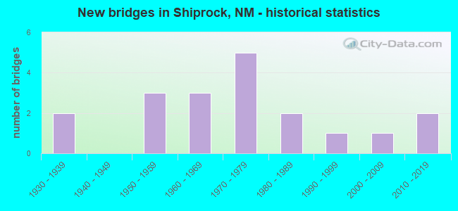
- New bridges - historical statistics
- 21930-1939
- 31950-1959
- 31960-1969
- 51970-1979
- 21980-1989
- 11990-1999
- 12000-2009
- 22010-2019


- Bridge Condition - Deck
- 18.2%Very good
- 18.2%Good
- 36.4%Satisfactory
- 18.2%Fair
- 9.1%Poor

- Bridge Condition - Superstructure
- 27.3%Very good
- 27.3%Good
- 36.4%Satisfactory
- 9.1%Poor

- Bridge Condition - Substructure
- 18.2%Very good
- 27.3%Good
- 27.3%Satisfactory
- 18.2%Fair
- 9.1%Poor

- Bridge Condition - Channel
- 10.5%Very good
- 26.3%Good
- 42.1%Satisfactory
- 15.8%Fair
- 5.3%Poor

- Bridge Condition - Culverts
- 12.5%Good
- 87.5%Satisfactory
Find on map >> Show street view
Structure Number: 1792, Location: US-491/US-64 in Shiprock (Lat: 36.781225, Lng: -108.692064), Route carried "on" structure: US 64, Year Built: 1936, Status: Open, Structure Length: 30.63m (100.49ft), Average Daily Traffic: 15,213 (year 2020), Truck Traffic: 7%, Average Future Daily Traffic: 21,409 (year 2040), Design Load: H 15, Features Intersected: SAN JUAN RIVER
Minimum Vertical Clearance: 4.27m (14.01ft), Kilometerpoint: 35.567, Lanes on structure: 2, Base Highway Network: Yes, Owner: State Highway Agency, Approaching Roadway Width: 7.3m (24.0ft), Skew: 10 degrees, Material/Design: Steel, Design/Construction: Truss - Thru, Number Of Spans In Main Unit: 6, Length of Maximum Span: 50.6m (166.0ft), Curb or Sidewalk Widths: Left: 2.1m (6.9ft), Right: 0.0m, Curb-To-Curb Width: 7.3m (24.0ft), Out-to-Out Width: 10.7m (35.1ft)
Condition: Deck: Poor, Superstructure: Poor, Substructure: Poor, Channel: Satisfactory, Operating Rating: 49.0 metric tons, Method Used To Determine Operating Rating: Load Factor (LF), Inventory Rating: 29.4 metric tons, Method Used To Determine Inventory Rating: Load Factor (LF), Structural Evaluation: Meets minimum limits, Deck Geometry: High priority of replacement, Waterway Adequacy: Equal to present minimum criteria, Approach Roadway Alignment: Equal to present desirable criteria, Length Of Structure Improvement: 30.57m (100.30ft), Designated Inspection Frequency: Every 12 months, Critical Feature Inspection Frequency: Every 12 months, Inspection Date: September 2021, Critical Feature Inspection Date: September 2021, Bridge Improvement Cost: $2,910,000, Roadway Improvement Cost: $250,000, Total Project Cost: $4,040,000 ( Estimate for 2020), Deck Structure Type: Concrete Cast-file-Place
Find on map >> Show street view
Structure Number: 2988, Location: 0.60 MI E OF JCT US 491 (Lat: 36.784347, Lng: -108.674333), Route carried "on" structure: US 64, Year Built: 1936, Year Reconstructed: 1974, Status: Open, Structure Length: 1.46m (4.79ft), Average Daily Traffic: 13,319 (year 2020), Truck Traffic: 16%, Average Future Daily Traffic: 10,280 (year 2040), Design Load: HS 20, Features Intersected: BAKER ARROYO
Minimum Vertical Clearance: 30+ m (98+ ft), Kilometerpoint: 40.071, Lanes on structure: 4, Base Highway Network: Yes, Owner: State Highway Agency, Approaching Roadway Width: 24.4m (80.1ft), Skew: 24 degrees, Material/Design: Concrete continuous, Design/Construction: Culvert, Number Of Spans In Main Unit: 3, Length of Maximum Span: 3.0m (9.8ft)
Condition: Channel: Satisfactory, Culverts: Satisfactory, Operating Rating: 53.5 metric tons, Method Used To Determine Operating Rating: Load Factor (LF), Inventory Rating: 32.4 metric tons, Method Used To Determine Inventory Rating: Load Factor (LF), Structural Evaluation: Equal to present minimum criteria, Waterway Adequacy: Better than present minimum criteria, Approach Roadway Alignment: Equal to present desirable criteria, Length Of Structure Improvement: 1.46m (4.79ft), Designated Inspection Frequency: Every 48 months, Inspection Date: December 2019, Bridge Improvement Cost: $239,000, Roadway Improvement Cost: $23,000, Total Project Cost: $359,000 ( Estimate for 2030)
Find on map >> Show street view
Structure Number: 5862, Location: 1.6 mi W of Jct U.S. 491 (Lat: 36.772861, Lng: -108.725672), Route carried "on" structure: US 64, Year Built: 1951, Year Reconstructed: 1960, Status: Open, Structure Length: 2.96m (9.71ft), Average Daily Traffic: 3,817 (year 2020), Truck Traffic: 20%, Average Future Daily Traffic: 6,374 (year 2040), Design Load: H 20, Features Intersected: RATTLESNAKE WASH
Minimum Vertical Clearance: 30+ m (98+ ft), Kilometerpoint: 32.669, Lanes on structure: 2, Base Highway Network: Yes, Owner: State Highway Agency, Approaching Roadway Width: 10.4m (34.1ft), Material/Design: Prestressed concrete, Design/Construction: Box Beam or Girders - Multiple, Number Of Spans In Main Unit: 2, Length of Maximum Span: 14.3m (46.9ft), Curb or Sidewalk Widths: Left: 0.7m (2.3ft), Right: 0.7m (2.3ft), Curb-To-Curb Width: 10.5m (34.4ft), Out-to-Out Width: 11.4m (37.4ft)
Condition: Deck: Satisfactory, Superstructure: Satisfactory, Substructure: Satisfactory, Channel: Satisfactory, Operating Rating: 77.7 metric tons, Method Used To Determine Operating Rating: Load Factor (LF), Inventory Rating: 46.5 metric tons, Method Used To Determine Inventory Rating: Load Factor (LF), Structural Evaluation: Equal to present minimum criteria, Deck Geometry: Somewhat better than minimum adequacy, Waterway Adequacy: Better than present minimum criteria, Approach Roadway Alignment: Equal to present desirable criteria, Length Of Structure Improvement: 2.93m (9.61ft), Designated Inspection Frequency: Every 24 months, Inspection Date: September 2019, Bridge Improvement Cost: $175,000, Roadway Improvement Cost: $17,000, Total Project Cost: $262,000 ( Estimate for 2030), Deck Structure Type: Concrete Precast Panels, Wearing Surface/Protective System: Wearing Surface: Bituminous
Find on map >> Show street view
Structure Number: 5863, Location: 7.9 MI W OF JCT US-491 (Lat: 36.792175, Lng: -108.833536), Route carried "on" structure: US 64, Year Built: 1956, Status: Open, Structure Length: 6.49m (21.29ft), Average Daily Traffic: 3,817 (year 2020), Truck Traffic: 20%, Average Future Daily Traffic: 6,374 (year 2040), Design Load: HS 20, Features Intersected: SHIPROCK WASH
Minimum Vertical Clearance: 30+ m (98+ ft), Kilometerpoint: 22.547, Lanes on structure: 2, Base Highway Network: Yes, Owner: State Highway Agency, Approaching Roadway Width: 8.5m (27.9ft), Material/Design: Steel continuous, Design/Construction: Stringer/Multi-beam, Number Of Spans In Main Unit: 3, Length of Maximum Span: 24.7m (81.0ft), Curb-To-Curb Width: 9.8m (32.2ft), Out-to-Out Width: 10.4m (34.1ft)
Condition: Deck: Satisfactory, Superstructure: Good, Substructure: Satisfactory, Channel: Fair, Operating Rating: 49.0 metric tons, Method Used To Determine Operating Rating: Load Factor (LF), Inventory Rating: 29.3 metric tons, Method Used To Determine Inventory Rating: Load Factor (LF), Structural Evaluation: Equal to present minimum criteria, Deck Geometry: Meets minimum limits, Waterway Adequacy: Equal to present desirable criteria, Approach Roadway Alignment: Better than present minimum criteria, Length Of Structure Improvement: 6.49m (21.29ft), Designated Inspection Frequency: Every 24 months, Inspection Date: May 2021, Bridge Improvement Cost: $349,000, Roadway Improvement Cost: $34,000, Total Project Cost: $524,000 ( Estimate for 2030), Deck Structure Type: Concrete Cast-file-Place, Wearing Surface/Protective System: Wearing Surface: Bituminous
Find on map >> Show street view
Structure Number: 5864, Location: 14.2 MI W OF JCT US-491 (Lat: 36.827075, Lng: -108.939542), Route carried "on" structure: US 64, Year Built: 1960, Status: Open, Structure Length: 7.96m (26.12ft), Average Daily Traffic: 3,817 (year 2020), Truck Traffic: 20%, Average Future Daily Traffic: 6,374 (year 2040), Design Load: HS 20, Features Intersected: RED WASH
Minimum Vertical Clearance: 30+ m (98+ ft), Kilometerpoint: 12.295, Lanes on structure: 2, Base Highway Network: Yes, Owner: State Highway Agency, Approaching Roadway Width: 9.4m (30.8ft), Skew: 3 degrees, Material/Design: Steel, Design/Construction: Stringer/Multi-beam, Number Of Spans In Main Unit: 6, Length of Maximum Span: 12.8m (42.0ft), Curb-To-Curb Width: 9.2m (30.2ft), Out-to-Out Width: 10.4m (34.1ft)
Condition: Deck: Fair, Superstructure: Satisfactory, Substructure: Satisfactory, Channel: Fair, Operating Rating: 45.1 metric tons, Method Used To Determine Operating Rating: Load Factor (LF), Inventory Rating: 27.0 metric tons, Method Used To Determine Inventory Rating: Load Factor (LF), Structural Evaluation: Equal to present minimum criteria, Deck Geometry: Meets minimum limits, Waterway Adequacy: Equal to present minimum criteria, Approach Roadway Alignment: Equal to present desirable criteria, Length Of Structure Improvement: 7.96m (26.12ft), Designated Inspection Frequency: Every 24 months, Inspection Date: May 2021, Bridge Improvement Cost: $709,000, Roadway Improvement Cost: $70,000, Total Project Cost: $1,064,000 ( Estimate for 2030), Deck Structure Type: Concrete Cast-file-Place, Wearing Surface/Protective System: Wearing Surface: Bituminous
Find on map >> Show street view
Structure Number: 5865, Location: NEW MEX./ARIZ STATE LINE (Lat: 36.871164, Lng: -109.044797), Route carried "on" structure: US 64, Year Built: 1956, Status: Open, Structure Length: 1.44m (4.72ft), Average Daily Traffic: 3,817 (year 2020), Truck Traffic: 20%, Average Future Daily Traffic: 6,374 (year 2040), Design Load: HS 20, Features Intersected: SHOE GAME WASH
Minimum Vertical Clearance: 30+ m (98+ ft), Kilometerpoint: 0.080, Lanes on structure: 2, Base Highway Network: Yes, Owner: State Highway Agency, Approaching Roadway Width: 7.3m (24.0ft), Material/Design: Concrete continuous, Design/Construction: Culvert, Number Of Spans In Main Unit: 5, Length of Maximum Span: 3.0m (9.8ft)
Condition: Channel: Satisfactory, Culverts: Satisfactory, Operating Rating: 55.1 metric tons, Method Used To Determine Operating Rating: Load Factor (LF), Inventory Rating: 32.4 metric tons, Method Used To Determine Inventory Rating: Load Factor (LF), Structural Evaluation: Equal to present minimum criteria, Waterway Adequacy: Equal to present desirable criteria, Approach Roadway Alignment: Equal to present desirable criteria, Length Of Structure Improvement: 1.65m (5.41ft), Designated Inspection Frequency: Every 48 months, Inspection Date: May 2021, Bridge Improvement Cost: $82,000, Roadway Improvement Cost: $8,000, Total Project Cost: $124,000 ( Estimate for 2030)
Find on map >> Show street view
Structure Number: 709, Location: US 491 MM 102.01 (Lat: 36.925642, Lng: -108.725281), Route carried "on" structure: US 491, Year Built: 1969, Status: Open, Structure Length: 1.31m (4.30ft), Average Daily Traffic: 3,662 (year 2020), Truck Traffic: 16%, Average Future Daily Traffic: 2,827 (year 2040), Design Load: HS 20, Features Intersected: MALPAIS ARROYO
Minimum Vertical Clearance: 30+ m (98+ ft), Kilometerpoint: 164.154, Lanes on structure: 3, Base Highway Network: Yes, Owner: State Highway Agency, Approaching Roadway Width: 14.0m (45.9ft), Material/Design: Concrete continuous, Design/Construction: Culvert, Number Of Spans In Main Unit: 4, Length of Maximum Span: 3.0m (9.8ft)
Condition: Channel: Good, Culverts: Satisfactory, Operating Rating: 38.9 metric tons, Method Used To Determine Operating Rating: Load Factor (LF), Inventory Rating: 32.4 metric tons, Method Used To Determine Inventory Rating: Load Factor (LF), Structural Evaluation: Equal to present minimum criteria, Waterway Adequacy: Better than present minimum criteria, Approach Roadway Alignment: Equal to present desirable criteria, Length Of Structure Improvement: 1.31m (4.30ft), Designated Inspection Frequency: Every 48 months, Inspection Date: December 2019, Bridge Improvement Cost: $176,000, Roadway Improvement Cost: $17,000, Total Project Cost: $265,000 ( Estimate for 2030)
Find on map >> Show street view
Structure Number: 7091, Location: US 491 MM 107.1 (Lat: 36.997347, Lng: -108.749686), Route carried "on" structure: US 491, Year Built: 1969, Status: Open, Structure Length: 3.17m (10.40ft), Average Daily Traffic: 3,662 (year 2020), Truck Traffic: 16%, Average Future Daily Traffic: 2,827 (year 2040), Design Load: HS 20, Features Intersected: UNNAMED WATERWAY
Minimum Vertical Clearance: 30+ m (98+ ft), Kilometerpoint: 172.360, Lanes on structure: 2, Base Highway Network: Yes, Owner: State Highway Agency, Approaching Roadway Width: 14.0m (45.9ft), Material/Design: Concrete continuous, Design/Construction: Culvert, Number Of Spans In Main Unit: 12, Length of Maximum Span: 2.4m (7.9ft)
Condition: Channel: Good, Culverts: Good, Operating Rating: 38.9 metric tons, Method Used To Determine Operating Rating: Load Factor (LF), Inventory Rating: 32.4 metric tons, Method Used To Determine Inventory Rating: Load Factor (LF), Structural Evaluation: Better than present minimum criteria, Waterway Adequacy: Equal to present minimum criteria, Approach Roadway Alignment: Better than present minimum criteria, Length Of Structure Improvement: 3.17m (10.40ft), Designated Inspection Frequency: Every 48 months, Inspection Date: December 2019, Bridge Improvement Cost: $428,000, Roadway Improvement Cost: $42,000, Total Project Cost: $642,000 ( Estimate for 2030)
Find on map >> Show street view
Structure Number: 7148, Location: US-64 Shiprock (Lat: 36.781147, Lng: -108.691936), Route carried "on" structure: US 64, Year Built: 1975, Status: Open, Structure Length: 30.66m (100.59ft), Average Daily Traffic: 15,213 (year 2020), Truck Traffic: 7%, Average Future Daily Traffic: 21,409 (year 2040), Design Load: HS 20, Features Intersected: SAN JUAN RIVER
Minimum Vertical Clearance: 30+ m (98+ ft), Kilometerpoint: 35.703, Lanes on structure: 2, Base Highway Network: Yes, Owner: State Highway Agency, Approaching Roadway Width: 12.6m (41.3ft), Skew: 10 degrees, Material/Design: Prestressed concrete, Design/Construction: Stringer/Multi-beam, Number Of Spans In Main Unit: 12, Length of Maximum Span: 25.0m (82.0ft), Curb or Sidewalk Widths: Left: 0.0m, Right: 1.5m (4.9ft), Curb-To-Curb Width: 12.5m (41.0ft), Out-to-Out Width: 13.7m (44.9ft)
Condition: Deck: Satisfactory, Superstructure: Satisfactory, Substructure: Fair, Channel: Poor, Operating Rating: 53.5 metric tons, Method Used To Determine Operating Rating: Load Factor (LF), Inventory Rating: 32.7 metric tons, Method Used To Determine Inventory Rating: Load Factor (LF), Structural Evaluation: Somewhat better than minimum adequacy, Deck Geometry: Better than present minimum criteria, Waterway Adequacy: Equal to present desirable criteria, Approach Roadway Alignment: Equal to present desirable criteria, Designated Inspection Frequency: Every 24 months, Inspection Date: Febuary 2021, Deck Structure Type: Concrete Cast-file-Place, Wearing Surface/Protective System: Wearing Surface: Epoxy Overlay
Find on map >> Show street view
Structure Number: 748, Location: 3.0 MI N OF JCT US-64 (Lat: 36.827092, Lng: -108.692703), Route carried "on" structure: US 491, Year Built: 1974, Status: Open, Structure Length: 6.42m (21.06ft), Average Daily Traffic: 3,662 (year 2020), Truck Traffic: 16%, Average Future Daily Traffic: 2,827 (year 2040), Design Load: HS 20, Features Intersected: SALT CREEK
Minimum Vertical Clearance: 30+ m (98+ ft), Kilometerpoint: 152.880, Lanes on structure: 2, Base Highway Network: Yes, Owner: State Highway Agency, Approaching Roadway Width: 13.4m (44.0ft), Skew: 1 degrees, Material/Design: Prestressed concrete continuous, Design/Construction: Stringer/Multi-beam, Number Of Spans In Main Unit: 3, Length of Maximum Span: 21.3m (69.9ft), Curb-To-Curb Width: 13.4m (44.0ft), Out-to-Out Width: 14.5m (47.6ft)
Condition: Deck: Fair, Superstructure: Good, Substructure: Good, Channel: Fair, Operating Rating: 54.1 metric tons, Method Used To Determine Operating Rating: Load Factor (LF), Inventory Rating: 33.3 metric tons, Method Used To Determine Inventory Rating: Load Factor (LF), Structural Evaluation: Better than present minimum criteria, Deck Geometry: Better than present minimum criteria, Waterway Adequacy: Equal to present desirable criteria, Approach Roadway Alignment: Equal to present desirable criteria, Length Of Structure Improvement: 6.10m (20.01ft), Designated Inspection Frequency: Every 24 months, Inspection Date: September 2019, Bridge Improvement Cost: $100,000, Roadway Improvement Cost: $50,000, Total Project Cost: $300,000 ( Estimate for 2030), Deck Structure Type: Concrete Cast-file-Place, Wearing Surface/Protective System: Wearing Surface: Epoxy Overlay, Deck Protection: Epoxy Coated Reinforcing
Find on map >> Show street view
Structure Number: 7956, Location: 5.3 MI N OF JCT US-64 (Lat: 36.859983, Lng: -108.703569), Route carried "on" structure: US 491, Year Built: 1978, Status: Open, Structure Length: 1.20m (3.94ft), Average Daily Traffic: 3,662 (year 2020), Truck Traffic: 16%, Average Future Daily Traffic: 2,827 (year 2040), Design Load: HS 20, Features Intersected: YELLOW ARROYO
Minimum Vertical Clearance: 30+ m (98+ ft), Kilometerpoint: 156.750, Lanes on structure: 2, Base Highway Network: Yes, Owner: State Highway Agency, Approaching Roadway Width: 17.4m (57.1ft), Skew: 3 degrees, Material/Design: Concrete continuous, Design/Construction: Culvert, Number Of Spans In Main Unit: 3, Length of Maximum Span: 3.0m (9.8ft)
Condition: Channel: Good, Culverts: Satisfactory, Operating Rating: 89.1 metric tons, Method Used To Determine Operating Rating: Load Factor (LF), Inventory Rating: 32.4 metric tons, Method Used To Determine Inventory Rating: Load Factor (LF), Structural Evaluation: Equal to present minimum criteria, Waterway Adequacy: Equal to present desirable criteria, Approach Roadway Alignment: Equal to present desirable criteria, Length Of Structure Improvement: 1.19m (3.90ft), Designated Inspection Frequency: Every 48 months, Inspection Date: May 2021, Bridge Improvement Cost: $219,000, Roadway Improvement Cost: $21,000, Total Project Cost: $329,000 ( Estimate for 2030)
Find on map >> Show street view
Structure Number: 7957, Location: 8.3 MI N OF JCT US-64 (Lat: 36.900947, Lng: -108.717111), Route carried "on" structure: US 491, Year Built: 1978, Status: Open, Structure Length: 0.80m (2.62ft), Average Daily Traffic: 3,662 (year 2020), Truck Traffic: 16%, Average Future Daily Traffic: 2,827 (year 2040), Design Load: HS 20, Features Intersected: MALPAS ARROYO
Minimum Vertical Clearance: 30+ m (98+ ft), Kilometerpoint: 161.417, Lanes on structure: 2, Base Highway Network: Yes, Owner: State Highway Agency, Approaching Roadway Width: 14.0m (45.9ft), Skew: 1 degrees, Material/Design: Concrete continuous, Design/Construction: Culvert, Number Of Spans In Main Unit: 2, Length of Maximum Span: 3.7m (12.1ft)
Condition: Channel: Satisfactory, Culverts: Satisfactory, Operating Rating: 89.1 metric tons, Method Used To Determine Operating Rating: Load Factor (LF), Inventory Rating: 32.4 metric tons, Method Used To Determine Inventory Rating: Load Factor (LF), Structural Evaluation: Equal to present minimum criteria, Waterway Adequacy: Equal to present desirable criteria, Approach Roadway Alignment: Equal to present desirable criteria, Length Of Structure Improvement: 0.88m (2.89ft), Designated Inspection Frequency: Every 48 months, Inspection Date: May 2021, Bridge Improvement Cost: $196,000, Roadway Improvement Cost: $19,000, Total Project Cost: $294,000 ( Estimate for 2030)
Find on map >> Show street view
Structure Number: 8211, Location: 23.6 miSouth Jct US 64/49 (Lat: 36.440219, Lng: -108.721561), Route carried "on" structure: US 491, Year Built: 1981, Status: Open, Structure Length: 3.98m (13.06ft), Average Daily Traffic: 9,647 (year 2020), Truck Traffic: 16%, Average Future Daily Traffic: 7,446 (year 2040), Design Load: HS 20, Features Intersected: PENA BLANCA WASH
Minimum Vertical Clearance: 30+ m (98+ ft), Kilometerpoint: 108.953, Lanes on structure: 2, Base Highway Network: Yes, Owner: State Highway Agency, Approaching Roadway Width: 13.8m (45.3ft), Skew: 1 degrees, Material/Design: Prestressed concrete continuous, Design/Construction: Stringer/Multi-beam, Number Of Spans In Main Unit: 2, Length of Maximum Span: 19.5m (64.0ft), Curb-To-Curb Width: 13.4m (44.0ft), Out-to-Out Width: 14.8m (48.6ft)
Condition: Deck: Good, Superstructure: Good, Substructure: Good, Channel: Good, Operating Rating: 71.3 metric tons, Method Used To Determine Operating Rating: Load Factor (LF), Inventory Rating: 32.4 metric tons, Method Used To Determine Inventory Rating: Load Factor (LF), Structural Evaluation: Better than present minimum criteria, Deck Geometry: Equal to present minimum criteria, Waterway Adequacy: Equal to present desirable criteria, Approach Roadway Alignment: Equal to present desirable criteria, Length Of Structure Improvement: 4.02m (13.19ft), Designated Inspection Frequency: Every 24 months, Inspection Date: September 2020, Bridge Improvement Cost: $303,000, Roadway Improvement Cost: $30,000, Total Project Cost: $455,000 ( Estimate for 2030), Deck Structure Type: Concrete Cast-file-Place, Wearing Surface/Protective System: Wearing Surface: Epoxy Overlay, Deck Protection: Epoxy Coated Reinforcing
Find on map >> Show street view
Structure Number: 9338, Location: 23.6 M S JCt 64/491 (Lat: 36.440200, Lng: -108.721300), Route carried "on" structure: US 491, Year Built: 2014, Status: Open, Structure Length: 3.99m (13.09ft), Average Daily Traffic: 9,647 (year 2020), Truck Traffic: 16%, Average Future Daily Traffic: 7,446 (year 2040), Design Load: HL 93, Features Intersected: Pena Blanca Wash
Minimum Vertical Clearance: 30+ m (98+ ft), Kilometerpoint: 108.953, Lanes on structure: 2, Base Highway Network: Yes, Owner: State Highway Agency, Approaching Roadway Width: 11.0m (36.1ft), Material/Design: Prestressed concrete continuous, Design/Construction: Stringer/Multi-beam, Number Of Spans In Main Unit: 2, Length of Maximum Span: 20.1m (65.9ft), Curb or Sidewalk Widths: Left: 0.5m (1.6ft), Right: 0.5m (1.6ft), Curb-To-Curb Width: 11.0m (36.1ft), Out-to-Out Width: 11.9m (39.0ft)
Condition: Deck: Good, Superstructure: Very good, Substructure: Very good, Channel: Very good, Operating Rating: 73.5 metric tons, Method Used To Determine Operating Rating: Load Factor (LF), Inventory Rating: 45.4 metric tons, Method Used To Determine Inventory Rating: Load Factor (LF), Structural Evaluation: Equal to present desirable criteria, Deck Geometry: Equal to present minimum criteria, Waterway Adequacy: Equal to present desirable criteria, Approach Roadway Alignment: Equal to present desirable criteria, Designated Inspection Frequency: Every 24 months, Inspection Date: September 2020, Deck Structure Type: Concrete Cast-file-Place, Wearing Surface/Protective System: Deck Protection: Epoxy Coated Reinforcing
Find on map >> Show street view
Structure Number: N245, Location: 11MI WEST OF FRUITLAND NM (Lat: 36.721500, Lng: -108.578194), Route carried "on" structure: Federal lands road N36, Year Built: 1990, Status: Open, Structure Length: 11.42m (37.47ft), Average Daily Traffic: 1,711 (year 2022), Truck Traffic: 25%, Average Future Daily Traffic: 2,574 (year 2040), Design Load: HS 20, Features Intersected: CHACO RIVER
Minimum Vertical Clearance: 30+ m (98+ ft), Kilometerpoint: 12.551, Lanes on structure: 2, Owner: Bureau of Indian Affairs, Approaching Roadway Width: 10.4m (34.1ft), Material/Design: Prestressed concrete continuous, Design/Construction: Stringer/Multi-beam, Number Of Spans In Main Unit: 3, Length of Maximum Span: 37.9m (124.3ft), Curb-To-Curb Width: 10.4m (34.1ft), Out-to-Out Width: 11.3m (37.1ft)
Condition: Deck: Satisfactory, Superstructure: Satisfactory, Substructure: Good, Channel: Good, Operating Rating: 80.7 metric tons, Method Used To Determine Operating Rating: Allowable Stress (AS), Inventory Rating: 48.1 metric tons, Method Used To Determine Inventory Rating: Allowable Stress (AS), Structural Evaluation: Equal to present minimum criteria, Deck Geometry: Equal to present minimum criteria, Waterway Adequacy: Superior to present desirable criteria, Approach Roadway Alignment: Equal to present desirable criteria, Designated Inspection Frequency: Every 24 months, Inspection Date: January 2022, Deck Structure Type: Concrete Cast-file-Place, Wearing Surface/Protective System: Wearing Surface: Monolithic Concrete, Deck Protection: Epoxy Coated Reinforcing
Find on map >> Show street view
Structure Number: N263, Location: 8.3 KM W OF SHIPROCK (Lat: 36.825750, Lng: -108.725528), Route carried "on" structure: Federal lands road N364, Year Built: 2000, Status: Open, Structure Length: 2.53m (8.30ft), Average Daily Traffic: 3,850 (year 2022), Truck Traffic: 30%, Average Future Daily Traffic: 3,204 (year 2032), Design Load: HS 20, Features Intersected: SALT CREEK
Minimum Vertical Clearance: 99.90m (327.76ft), Kilometerpoint: 0.000, Lanes on structure: 2, Owner: Bureau of Indian Affairs, Approaching Roadway Width: 10.7m (35.1ft), Material/Design: Prestressed concrete, Design/Construction: Box Beam or Girders - Multiple, Number Of Spans In Main Unit: 1, Length of Maximum Span: 24.7m (81.0ft), Curb-To-Curb Width: 10.8m (35.4ft), Out-to-Out Width: 11.1m (36.4ft)
Condition: Deck: Very good, Superstructure: Very good, Substructure: Fair, Channel: Satisfactory, Operating Rating: 44.5 metric tons, Method Used To Determine Operating Rating: Allowable Stress (AS), Inventory Rating: 32.7 metric tons, Method Used To Determine Inventory Rating: Allowable Stress (AS), Structural Evaluation: Somewhat better than minimum adequacy, Deck Geometry: Somewhat better than minimum adequacy, Waterway Adequacy: Equal to present minimum criteria, Approach Roadway Alignment: Equal to present desirable criteria, Designated Inspection Frequency: Every 24 months, Inspection Date: January 2022, Deck Structure Type: Concrete Precast Panels, Wearing Surface/Protective System: Wearing Surface: Bituminous, Membrane: Preformed Fabric, Deck Protection: Epoxy Coated Reinforcing
Find on map >> Show street view
Structure Number: N264, Location: 4 MI E NMHWY491 ON N36 (Lat: 36.714167, Lng: -108.634944), Route carried "on" structure: Federal lands road N36, Year Built: 1988, Status: Open, Structure Length: 2.67m (8.76ft), Average Daily Traffic: 1,711 (year 2022), Truck Traffic: 25%, Average Future Daily Traffic: 2,574 (year 2040), Design Load: HS 20, Features Intersected: WASH, Facility Carried by Structure: IRR BIA RTE N33
Minimum Vertical Clearance: 30+ m (98+ ft), Kilometerpoint: 6.650, Lanes on structure: 2, Owner: Bureau of Indian Affairs, Approaching Roadway Width: 9.3m (30.5ft), Material/Design: Steel, Design/Construction: Culvert, Number Of Spans In Main Unit: 5, Length of Maximum Span: 4.6m (15.1ft), Curb-To-Curb Width: 11.3m (37.1ft), Out-to-Out Width: 23.1m (75.8ft)
Condition: Channel: Satisfactory, Culverts: Satisfactory, Operating Rating: 49.1 metric tons, Method Used To Determine Operating Rating: Allowable Stress (AS), Inventory Rating: 36.0 metric tons, Method Used To Determine Inventory Rating: Allowable Stress (AS), Structural Evaluation: Equal to present minimum criteria, Deck Geometry: Equal to present minimum criteria, Waterway Adequacy: Equal to present desirable criteria, Approach Roadway Alignment: Equal to present desirable criteria, Designated Inspection Frequency: Every 24 months, Inspection Date: January 2022
Find on map >> Show street view
Structure Number: N267, Location: 0.5 MILES NORTH OF US 64 (Lat: 36.773611, Lng: -108.607639), Route carried "on" structure: Federal lands road N5031, Year Built: 2012, Status: Open, Structure Length: 1.35m (4.43ft), Average Daily Traffic: 1,155 (year 2022), Truck Traffic: 15%, Average Future Daily Traffic: 708 (year 2040), Design Load: HS 20, Features Intersected: HOGBACK IRRIGATION CANAL
Minimum Vertical Clearance: 30+ m (98+ ft), Kilometerpoint: 0.000, Lanes on structure: 2, Owner: Bureau of Indian Affairs, Approaching Roadway Width: 10.2m (33.5ft), Material/Design: Prestressed concrete, Design/Construction: Box Beam or Girders - Multiple, Number Of Spans In Main Unit: 1, Length of Maximum Span: 11.3m (37.1ft), Curb-To-Curb Width: 10.2m (33.5ft), Out-to-Out Width: 11.0m (36.1ft)
Condition: Deck: Very good, Superstructure: Very good, Substructure: Very good, Channel: Very good, Operating Rating: 58.8 metric tons, Method Used To Determine Operating Rating: Load Factor (LF), Inventory Rating: 35.3 metric tons, Method Used To Determine Inventory Rating: Load Factor (LF), Structural Evaluation: Equal to present desirable criteria, Deck Geometry: Somewhat better than minimum adequacy, Waterway Adequacy: Superior to present desirable criteria, Approach Roadway Alignment: Equal to present desirable criteria, Designated Inspection Frequency: Every 24 months, Inspection Date: January 2022, Deck Structure Type: Other, Wearing Surface/Protective System: Wearing Surface: Bituminous, Membrane: Other
Find on map >> Show street view
Structure Number: 10096, Location: 4.8 MI E OF US-491 (Lat: 36.768317, Lng: -108.600228), Route carried "on" structure: US 64, Year Built: 1976, Status: Open, Structure Length: 2.80m (9.19ft), Average Daily Traffic: 13,319 (year 2020), Truck Traffic: 16%, Average Future Daily Traffic: 10,280 (year 2040), Design Load: HS 20, Features Intersected: IRRIGATION CHANNEL
Minimum Vertical Clearance: 30+ m (98+ ft), Kilometerpoint: 44.743, Lanes on structure: 4, Base Highway Network: Yes, Owner: State Highway Agency, Approaching Roadway Width: 28.5m (93.5ft), Skew: 11 degrees, Material/Design: Concrete continuous, Design/Construction: Culvert, Number Of Spans In Main Unit: 5, Length of Maximum Span: 4.6m (15.1ft)
Condition: Channel: Satisfactory, Culverts: Satisfactory, Operating Rating: 87.5 metric tons, Method Used To Determine Operating Rating: Load Factor (LF), Inventory Rating: 32.4 metric tons, Method Used To Determine Inventory Rating: Load Factor (LF), Structural Evaluation: Equal to present minimum criteria, Waterway Adequacy: Equal to present minimum criteria, Approach Roadway Alignment: Equal to present minimum criteria, Designated Inspection Frequency: Every 24 months, Inspection Date: Febuary 2022, Wearing Surface/Protective System: Wearing Surface: Bituminous