Bridge Statistics for Woodway, Texas (TX)
Condition, Traffic, Stress, Structural Evaluation, Project Costs
- National Bridge Inventory (NBI) Statistics
- 18Number of bridges
- 200ft / 61.3mTotal length
- $11,227,000Total costs
- 225,448Total average daily traffic
- 10,076Total average daily truck traffic
- National Bridge Inventory (NBI) Registered Bridges for Woodway
- No street view available for this location
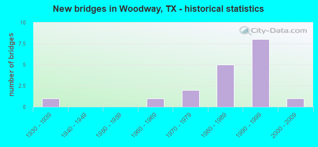
- New bridges - historical statistics
- 11930-1939
- 11960-1969
- 21970-1979
- 51980-1989
- 81990-1999
- 12000-2009
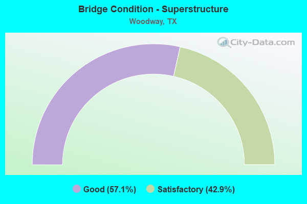
- Bridge Condition - Superstructure
- 57.1%Good
- 42.9%Satisfactory
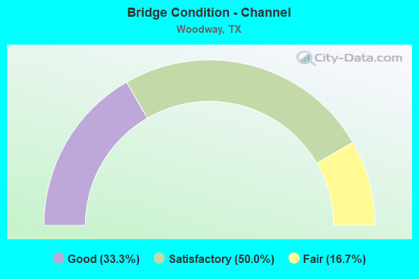
- Bridge Condition - Channel
- 33.3%Good
- 50.0%Satisfactory
- 16.7%Fair
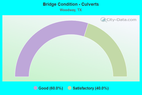
- Bridge Condition - Culverts
- 60.0%Good
- 40.0%Satisfactory
Find on map >> Show street view
Structure Number: 91610005508018, Location: 5.1 MI W OF SH 6 (Lat: 31.484936, Lng: -97.267958), Route carried "on" structure: ServiceUS 84, Year Built: 1933, Status: Open, Structure Length: 0.73m (2.40ft), Average Daily Traffic: 1,410 (year 2017), Truck Traffic: 3%, Average Future Daily Traffic: 1,980 (year 2037), Features Intersected: CLOICE CREEK
Minimum Vertical Clearance: 30+ m (98+ ft), Kilometerpoint: 23.036, Lanes on structure: 2, Owner: State Highway Agency, Approaching Roadway Width: 8.2m (26.9ft), Material/Design: Concrete, Design/Construction: Culvert, Number Of Spans In Main Unit: 2, Length of Maximum Span: 3.0m (9.8ft)
Condition: Channel: Satisfactory, Culverts: Satisfactory, Operating Rating: 39.9 metric tons, Method Used To Determine Operating Rating: Load Factor (LF), Inventory Rating: 23.6 metric tons, Method Used To Determine Inventory Rating: Load Factor (LF), Structural Evaluation: Equal to present minimum criteria, Waterway Adequacy: Equal to present minimum criteria, Approach Roadway Alignment: Equal to present desirable criteria, Length Of Structure Improvement: 1.83m (6.00ft), Designated Inspection Frequency: Every 24 months, Inspection Date: March 2021, Bridge Improvement Cost: $200,000, Roadway Improvement Cost: $100,000, Total Project Cost: $400,000
Find on map >> Show street view
Structure Number: 91610005508057, Location: 0.4 Mi W of SH 6 (Lat: 31.509017, Lng: -97.194589), Route carried "on" structure: US 84, Year Built: 1964, Status: Open, Structure Length: 1.10m (3.61ft), Average Daily Traffic: 31,076 (year 2020), Truck Traffic: 2%, Average Future Daily Traffic: 43,490 (year 2037), Design Load: HS 20, Features Intersected: N Flat Creek
Minimum Vertical Clearance: 30+ m (98+ ft), Kilometerpoint: 30.595, Lanes on structure: 10, Base Highway Network: Yes, Owner: State Highway Agency, Approaching Roadway Width: 39.0m (128.0ft), Skew: 21 degrees, Material/Design: Concrete, Design/Construction: Culvert, Number Of Spans In Main Unit: 4, Length of Maximum Span: 2.4m (7.9ft)
Condition: Channel: Good, Culverts: Good, Operating Rating: 39.9 metric tons, Method Used To Determine Operating Rating: Load Factor (LF), Inventory Rating: 23.6 metric tons, Method Used To Determine Inventory Rating: Load Factor (LF), Structural Evaluation: Somewhat better than minimum adequacy, Waterway Adequacy: Equal to present minimum criteria, Approach Roadway Alignment: Equal to present desirable criteria, Length Of Structure Improvement: 1.83m (6.00ft), Designated Inspection Frequency: Every 24 months, Inspection Date: March 2021, Bridge Improvement Cost: $200,000, Roadway Improvement Cost: $100,000, Total Project Cost: $400,000
Find on map >> Show street view
Structure Number: 91610005508065, Location: 2.0 MI W OF SH 6 (Lat: 31.496911, Lng: -97.219881), Route carried "on" structure: State highway 1695, Year Built: 1975, Status: Open, Structure Length: 7.50m (24.61ft), Average Daily Traffic: 30,807 (year 2017), Truck Traffic: 2%, Average Future Daily Traffic: 37,590 (year 2037), Design Load: HS 20, Features Intersected: US 84
Minimum Vertical Clearance: 30+ m (98+ ft), Kilometerpoint: 32.150, Lanes on structure: 5, Lanes under structure: 4, Base Highway Network: Yes, Owner: State Highway Agency, Approaching Roadway Width: 20.1m (65.9ft), Material/Design: Prestressed concrete continuous, Design/Construction: Slab, Number Of Spans In Main Unit: 4, Length of Maximum Span: 23.8m (78.1ft), Curb or Sidewalk Widths: Left: 1.1m (3.6ft), Right: 1.1m (3.6ft), Curb-To-Curb Width: 20.1m (65.9ft), Out-to-Out Width: 23.0m (75.5ft)
Condition: Deck: Good, Superstructure: Good, Substructure: Good, Operating Rating: 54.4 metric tons, Method Used To Determine Operating Rating: Assigned rating based on Load Factor Design (LFD) reported in metric tons, Inventory Rating: 32.7 metric tons, Method Used To Determine Inventory Rating: Assigned rating based on Load Factor Design (LFD) reported in metric tons, Structural Evaluation: Better than present minimum criteria, Deck Geometry: Somewhat better than minimum adequacy, Underclear: Equal to present minimum criteria, Approach Roadway Alignment: Equal to present desirable criteria, Length Of Structure Improvement: 9.39m (30.81ft), Designated Inspection Frequency: Every 24 months, Inspection Date: March 2021, Bridge Improvement Cost: $900,000, Roadway Improvement Cost: $300,000, Total Project Cost: $1,400,000, Deck Structure Type: Concrete Cast-file-Place
Find on map >> Show street view
Structure Number: 91610005508068, Location: 1.1 Mi W of SH 6 (Lat: 31.504561, Lng: -97.204056), Route carried "on" structure: US 84, Year Built: 1986, Status: Open, Structure Length: 8.23m (27.00ft), Average Daily Traffic: 13,938 (year 2019), Truck Traffic: 5%, Average Future Daily Traffic: 36,450 (year 2037), Design Load: HS 20, Features Intersected: Texas Central Pkwy
Minimum Vertical Clearance: 30+ m (98+ ft), Kilometerpoint: 29.506, Lanes on structure: 2, Lanes under structure: 6, Base Highway Network: Yes, Owner: State Highway Agency, Approaching Roadway Width: 12.2m (40.0ft), Material/Design: Prestressed concrete, Design/Construction: Stringer/Multi-beam, Number Of Spans In Main Unit: 1, Number Of Approach Spans: 2, Length of Maximum Span: 35.4m (116.1ft), Curb-To-Curb Width: 12.2m (40.0ft), Out-to-Out Width: 12.8m (42.0ft)
Condition: Deck: Good, Superstructure: Satisfactory, Substructure: Good, Operating Rating: 54.4 metric tons, Method Used To Determine Operating Rating: Assigned rating based on Load Factor Design (LFD) reported in metric tons, Inventory Rating: 32.7 metric tons, Method Used To Determine Inventory Rating: Assigned rating based on Load Factor Design (LFD) reported in metric tons, Structural Evaluation: Equal to present minimum criteria, Deck Geometry: Better than present minimum criteria, Underclear: Better than present minimum criteria, Approach Roadway Alignment: Equal to present desirable criteria, Length Of Structure Improvement: 10.30m (33.79ft), Designated Inspection Frequency: Every 24 months, Inspection Date: March 2021, Bridge Improvement Cost: $1,000,000, Roadway Improvement Cost: $300,000, Total Project Cost: $1,500,000, Deck Structure Type: Concrete Cast-file-Place, Wearing Surface/Protective System: Wearing Surface: Bituminous
Find on map >> Show street view
Structure Number: 91610005508069, Location: 1.1 Mi W of SH 6 (Lat: 31.503931, Lng: -97.204644), Route carried "on" structure: US 84, Year Built: 1986, Status: Open, Structure Length: 8.23m (27.00ft), Average Daily Traffic: 26,038 (year 2019), Truck Traffic: 5%, Average Future Daily Traffic: 36,450 (year 2037), Design Load: HS 20, Features Intersected: Texas Central Pkwy
Minimum Vertical Clearance: 30+ m (98+ ft), Kilometerpoint: 29.506, Lanes on structure: 2, Lanes under structure: 6, Base Highway Network: Yes, Owner: State Highway Agency, Approaching Roadway Width: 12.2m (40.0ft), Material/Design: Prestressed concrete, Design/Construction: Stringer/Multi-beam, Number Of Spans In Main Unit: 1, Number Of Approach Spans: 2, Length of Maximum Span: 35.4m (116.1ft), Curb-To-Curb Width: 12.2m (40.0ft), Out-to-Out Width: 12.8m (42.0ft)
Condition: Deck: Good, Superstructure: Satisfactory, Substructure: Good, Operating Rating: 54.4 metric tons, Method Used To Determine Operating Rating: Assigned rating based on Load Factor Design (LFD) reported in metric tons, Inventory Rating: 32.7 metric tons, Method Used To Determine Inventory Rating: Assigned rating based on Load Factor Design (LFD) reported in metric tons, Structural Evaluation: Equal to present minimum criteria, Deck Geometry: Better than present minimum criteria, Underclear: Better than present minimum criteria, Approach Roadway Alignment: Equal to present desirable criteria, Length Of Structure Improvement: 10.30m (33.79ft), Designated Inspection Frequency: Every 24 months, Inspection Date: March 2021, Bridge Improvement Cost: $1,000,000, Roadway Improvement Cost: $300,000, Total Project Cost: $1,500,000, Deck Structure Type: Concrete Cast-file-Place, Wearing Surface/Protective System: Wearing Surface: Bituminous
Find on map >> Show street view
Structure Number: 9161000550807, Location: 1.7 MI W OF FM 1695 (Lat: 31.489175, Lng: -97.239931), Route carried "on" structure: County highway , Year Built: 1995, Status: Open, Structure Length: 10.97m (35.99ft), Average Daily Traffic: 538 (year 2015), Truck Traffic: 3%, Average Future Daily Traffic: 985 (year 2037), Design Load: HS 20, Features Intersected: US 84, Facility Carried by Structure: RITCHIE RD
Minimum Vertical Clearance: 30+ m (98+ ft), Kilometerpoint: 0.002, Lanes on structure: 5, Lanes under structure: 6, Base Highway Network: Yes, Owner: State Highway Agency, Approaching Roadway Width: 22.6m (74.1ft), Skew: 1 degrees, Material/Design: Prestressed concrete, Design/Construction: Stringer/Multi-beam, Number Of Spans In Main Unit: 3, Length of Maximum Span: 36.6m (120.1ft), Curb or Sidewalk Widths: Left: 1.3m (4.3ft), Right: 0.0m, Curb-To-Curb Width: 20.1m (65.9ft), Out-to-Out Width: 22.5m (73.8ft)
Condition: Deck: Good, Superstructure: Satisfactory, Substructure: Good, Operating Rating: 54.4 metric tons, Method Used To Determine Operating Rating: Assigned rating based on Load Factor Design (LFD) reported in metric tons, Inventory Rating: 32.7 metric tons, Method Used To Determine Inventory Rating: Assigned rating based on Load Factor Design (LFD) reported in metric tons, Structural Evaluation: Equal to present minimum criteria, Deck Geometry: Somewhat better than minimum adequacy, Underclear: Equal to present minimum criteria, Approach Roadway Alignment: Equal to present desirable criteria, Length Of Structure Improvement: 13.72m (45.01ft), Designated Inspection Frequency: Every 24 months, Inspection Date: March 2021, Bridge Improvement Cost: $1,400,000, Roadway Improvement Cost: $400,000, Total Project Cost: $2,100,000, Deck Structure Type: Concrete Cast-file-Place, Wearing Surface/Protective System: Wearing Surface: Bituminous
Find on map >> Show street view
Structure Number: 91610005508071, Location: 1.1 MI W OF FM 1695 (Lat: 31.492786, Lng: -97.230503), Route carried "on" structure: US 84, Year Built: 1995, Status: Open, Structure Length: 9.14m (29.99ft), Average Daily Traffic: 11,824 (year 2019), Truck Traffic: 7%, Average Future Daily Traffic: 22,705 (year 2037), Design Load: HS 20, Features Intersected: POAGE DR
Minimum Vertical Clearance: 30+ m (98+ ft), Kilometerpoint: 26.240, Lanes on structure: 2, Lanes under structure: 5, Base Highway Network: Yes, Owner: State Highway Agency, Approaching Roadway Width: 12.8m (42.0ft), Material/Design: Prestressed concrete, Design/Construction: Stringer/Multi-beam, Number Of Spans In Main Unit: 3, Length of Maximum Span: 30.5m (100.1ft), Curb-To-Curb Width: 12.2m (40.0ft), Out-to-Out Width: 12.8m (42.0ft)
Condition: Deck: Good, Superstructure: Good, Substructure: Good, Operating Rating: 54.4 metric tons, Method Used To Determine Operating Rating: Assigned rating based on Load Factor Design (LFD) reported in metric tons, Inventory Rating: 32.7 metric tons, Method Used To Determine Inventory Rating: Assigned rating based on Load Factor Design (LFD) reported in metric tons, Structural Evaluation: Better than present minimum criteria, Deck Geometry: Better than present minimum criteria, Underclear: Superior to present desirable criteria, Approach Roadway Alignment: Equal to present desirable criteria, Length Of Structure Improvement: 11.43m (37.50ft), Designated Inspection Frequency: Every 24 months, Inspection Date: March 2021, Bridge Improvement Cost: $1,100,000, Roadway Improvement Cost: $300,000, Total Project Cost: $1,700,000, Deck Structure Type: Concrete Precast Panels, Wearing Surface/Protective System: Wearing Surface: Bituminous
Find on map >> Show street view
Structure Number: 91610005508072, Location: 1.1 MI W OF FM 1695 (Lat: 31.492208, Lng: -97.231161), Route carried "on" structure: US 84, Year Built: 1995, Status: Open, Structure Length: 9.14m (29.99ft), Average Daily Traffic: 12,948 (year 2019), Truck Traffic: 7%, Average Future Daily Traffic: 22,705 (year 2037), Design Load: HS 20, Features Intersected: POAGE DR
Minimum Vertical Clearance: 30+ m (98+ ft), Kilometerpoint: 26.240, Lanes on structure: 2, Lanes under structure: 5, Base Highway Network: Yes, Owner: State Highway Agency, Approaching Roadway Width: 12.8m (42.0ft), Material/Design: Prestressed concrete, Design/Construction: Stringer/Multi-beam, Number Of Spans In Main Unit: 3, Length of Maximum Span: 30.5m (100.1ft), Curb-To-Curb Width: 12.2m (40.0ft), Out-to-Out Width: 12.8m (42.0ft)
Condition: Deck: Good, Superstructure: Good, Substructure: Good, Operating Rating: 54.4 metric tons, Method Used To Determine Operating Rating: Assigned rating based on Load Factor Design (LFD) reported in metric tons, Inventory Rating: 32.7 metric tons, Method Used To Determine Inventory Rating: Assigned rating based on Load Factor Design (LFD) reported in metric tons, Structural Evaluation: Better than present minimum criteria, Deck Geometry: Better than present minimum criteria, Underclear: Superior to present desirable criteria, Approach Roadway Alignment: Equal to present desirable criteria, Length Of Structure Improvement: 11.43m (37.50ft), Designated Inspection Frequency: Every 24 months, Inspection Date: March 2021, Bridge Improvement Cost: $1,100,000, Roadway Improvement Cost: $300,000, Total Project Cost: $1,700,000, Deck Structure Type: Concrete Precast Panels, Wearing Surface/Protective System: Wearing Surface: Bituminous
Find on map >> Show street view
Structure Number: 91610F00037001, Location: 0.40 MI NE OF US 84 (Lat: 31.487183, Lng: -97.251264), Route carried "on" structure: City street , Year Built: 2004, Status: Open, Structure Length: 0.70m (2.30ft), Average Daily Traffic: 4,160 (year 2013), Truck Traffic: 5%, Average Future Daily Traffic: 4,500 (year 2035), Features Intersected: MID BOSQUE RI TRIB #3WOO, Facility Carried by Structure: BADGER RANCH BLVD
Minimum Vertical Clearance: 30+ m (98+ ft), Kilometerpoint: 0.726, Lanes on structure: 2, Owner: City or Municipal Highway Agency, Approaching Roadway Width: 11.0m (36.1ft), Skew: 1 degrees, Material/Design: Concrete, Design/Construction: Culvert, Number Of Spans In Main Unit: 2, Length of Maximum Span: 2.7m (8.9ft), Curb or Sidewalk Widths: Left: 2.3m (7.5ft), Right: 3.0m (9.8ft)
Condition: Channel: Good, Culverts: Satisfactory, Operating Rating: 32.7 metric tons, Method Used To Determine Operating Rating: Field evaluation and documented engineering judgment, Inventory Rating: 24.5 metric tons, Method Used To Determine Inventory Rating: Field evaluation and documented engineering judgment, Structural Evaluation: Equal to present minimum criteria, Waterway Adequacy: Better than present minimum criteria, Approach Roadway Alignment: Equal to present desirable criteria, Designated Inspection Frequency: Every 24 months, Inspection Date: Febuary 2020
Find on map >> Show street view
Structure Number: 91610F00050001, Location: 0.45 MI SW OF SH 6 (Lat: 31.515756, Lng: -97.216636), Route carried "on" structure: City street , Year Built: 1990, Status: Open, Structure Length: 1.01m (3.31ft), Average Daily Traffic: 7,470 (year 2020), Truck Traffic: 5%, Average Future Daily Traffic: 5,000 (year 2035), Features Intersected: DRAW #2 WOO, Facility Carried by Structure: BOSQUE BLVD
Minimum Vertical Clearance: 30+ m (98+ ft), Kilometerpoint: 0.724, Lanes on structure: 4, Owner: City or Municipal Highway Agency, Approaching Roadway Width: 13.1m (43.0ft), Skew: 1 degrees, Material/Design: Concrete, Design/Construction: Culvert, Number Of Spans In Main Unit: 3, Length of Maximum Span: 2.7m (8.9ft), Curb-To-Curb Width: 13.3m (43.6ft), Out-to-Out Width: 19.1m (62.7ft)
Condition: Channel: Satisfactory, Culverts: Good, Operating Rating: 32.7 metric tons, Method Used To Determine Operating Rating: Field evaluation and documented engineering judgment, Inventory Rating: 24.5 metric tons, Method Used To Determine Inventory Rating: Field evaluation and documented engineering judgment, Structural Evaluation: Equal to present minimum criteria, Deck Geometry: High priority of replacement, Waterway Adequacy: Equal to present minimum criteria, Approach Roadway Alignment: Better than present minimum criteria, Length Of Structure Improvement: 1.01m (3.31ft), Designated Inspection Frequency: Every 24 months, Inspection Date: Febuary 2020, Bridge Improvement Cost: $3,000, Roadway Improvement Cost: $1,000, Total Project Cost: $4,000, Deck Structure Type: Concrete Precast Panels, Wearing Surface/Protective System: Wearing Surface: Bituminous
Find on map >> Show street view
Structure Number: 91610F00225001, Location: 1.05 MI NW of US 84 (Lat: 31.508678, Lng: -97.230586), Route carried "on" structure: City street , Year Built: 1989, Status: Open, Structure Length: 3.66m (12.01ft), Average Daily Traffic: 2,461 (year 2020), Average Future Daily Traffic: 1,500 (year 2036), Design Load: HS 20, Features Intersected: PORTER'S BRANCH #1 WOO, Facility Carried by Structure: ESTATES DR
Minimum Vertical Clearance: 30+ m (98+ ft), Kilometerpoint: 1.690, Lanes on structure: 2, Owner: City or Municipal Highway Agency, Approaching Roadway Width: 13.4m (44.0ft), Material/Design: Concrete, Design/Construction: Stringer/Multi-beam, Number Of Spans In Main Unit: 3, Length of Maximum Span: 12.2m (40.0ft), Curb or Sidewalk Widths: Left: 1.1m (3.6ft), Right: 1.1m (3.6ft), Curb-To-Curb Width: 13.4m (44.0ft), Out-to-Out Width: 16.1m (52.8ft)
Condition: Deck: Good, Superstructure: Good, Substructure: Good, Channel: Satisfactory, Operating Rating: 50.8 metric tons, Method Used To Determine Operating Rating: Load Factor (LF), Inventory Rating: 30.8 metric tons, Method Used To Determine Inventory Rating: Load Factor (LF), Structural Evaluation: Better than present minimum criteria, Deck Geometry: Better than present minimum criteria, Waterway Adequacy: Better than present minimum criteria, Approach Roadway Alignment: Equal to present desirable criteria, Length Of Structure Improvement: 4.57m (14.99ft), Designated Inspection Frequency: Every 24 months, Inspection Date: Febuary 2020, Bridge Improvement Cost: $419,000, Roadway Improvement Cost: $104,000, Total Project Cost: $523,000, Deck Structure Type: Concrete Cast-file-Place
Find on map >> Show street view
Structure Number: 91610F00235001, Location: 0.10 MI SW OF ESTATES DR (Lat: 31.506025, Lng: -97.229267), Route carried "on" structure: City street , Year Built: 1990, Status: Open, Structure Length: 0.88m (2.89ft), Average Daily Traffic: 2,500 (year 2018), Average Future Daily Traffic: 3,000 (year 2038), Features Intersected: POTTERS BRANCH, Facility Carried by Structure: W FAIRWAY DRIVE
Minimum Vertical Clearance: 30+ m (98+ ft), Kilometerpoint: 0.161, Lanes on structure: 2, Owner: City or Municipal Highway Agency, Approaching Roadway Width: 11.6m (38.1ft), Material/Design: Concrete, Design/Construction: Culvert, Number Of Spans In Main Unit: 3, Length of Maximum Span: 2.4m (7.9ft)
Condition: Channel: Fair, Culverts: Good, Operating Rating: 32.7 metric tons, Method Used To Determine Operating Rating: Field evaluation and documented engineering judgment, Inventory Rating: 24.5 metric tons, Method Used To Determine Inventory Rating: Field evaluation and documented engineering judgment, Structural Evaluation: Equal to present minimum criteria, Waterway Adequacy: Better than present minimum criteria, Approach Roadway Alignment: Equal to present desirable criteria, Designated Inspection Frequency: Every 24 months, Inspection Date: Febuary 2020
Find on map >> Show street view
Structure Number: 91610005508065, Location: 2.0 MI W OF SH 6 (Lat: 31.497400, Lng: -97.220164), Route carried "under" structure: US 84, Year Built: 1975, Structure Length: 0. m, Average Daily Traffic: 25,801 (year 2017), Truck Traffic: 7%, Features Intersected: US 84, Facility Carried by Structure: FM 1695
Minimum Vertical Clearance: 5.31m (17.42ft), Kilometerpoint: 27.866, Lanes on structure: 5, Lanes under structure: 4, Material/Design: Prestressed concrete continuous, Design/Construction: Slab, Length of Maximum Span: 23.8m (78.1ft)
Find on map >> Show street view
Structure Number: 91610005508068, Location: 1.1 Mi W of SH 6 (Lat: 31.504561, Lng: -97.204056), Route carried "under" structure: City street , Year Built: 1986, Structure Length: 0. m, Average Daily Traffic: 11,510 (year 2015), Truck Traffic: 3%, Features Intersected: Texas Central Pkwy, Facility Carried by Structure: US 84 WB
Minimum Vertical Clearance: 5.31m (17.42ft), Kilometerpoint: 29.506, Lanes on structure: 2, Lanes under structure: 6, Material/Design: Prestressed concrete, Design/Construction: Stringer/Multi-beam, Length of Maximum Span: 35.4m (116.1ft)
Find on map >> Show street view
Structure Number: 91610005508069, Location: 1.1 Mi W of SH 6 (Lat: 31.503931, Lng: -97.204644), Route carried "under" structure: City street , Year Built: 1986, Structure Length: 0. m, Average Daily Traffic: 11,510 (year 2015), Truck Traffic: 3%, Features Intersected: Texas Central Pkwy, Facility Carried by Structure: US 84 EB
Minimum Vertical Clearance: 5.36m (17.59ft), Kilometerpoint: 29.506, Lanes on structure: 2, Lanes under structure: 6, Material/Design: Prestressed concrete, Design/Construction: Stringer/Multi-beam, Length of Maximum Span: 35.4m (116.1ft)
Find on map >> Show street view
Structure Number: 9161000550807, Location: 1.7 MI W OF FM 1695 (Lat: 31.488869, Lng: -97.239411), Route carried "under" structure: US 84, Year Built: 1995, Structure Length: 0. m, Average Daily Traffic: 25,801 (year 2017), Truck Traffic: 7%, Features Intersected: US 84, Facility Carried by Structure: RITCHIE RD
Minimum Vertical Clearance: 6.45m (21.16ft), Kilometerpoint: 20.122, Lanes on structure: 5, Lanes under structure: 6, Material/Design: Prestressed concrete, Design/Construction: Stringer/Multi-beam, Length of Maximum Span: 36.6m (120.1ft)
Find on map >> Show street view
Structure Number: 91610005508071, Location: 1.1 MI W OF FM 1695 (Lat: 31.492689, Lng: -97.230958), Route carried "under" structure: City street , Year Built: 1995, Structure Length: 0. m, Average Daily Traffic: 2,828 (year 2015), Truck Traffic: 3%, Features Intersected: Poage Dr, Facility Carried by Structure: US 84 WB
Minimum Vertical Clearance: 5.54m (18.18ft), Kilometerpoint: 26.240, Lanes on structure: 2, Lanes under structure: 5, Material/Design: Prestressed concrete, Design/Construction: Stringer/Multi-beam, Length of Maximum Span: 30.5m (100.1ft)
Find on map >> Show street view
Structure Number: 91610005508072, Location: 1.1 MI W OF FM 1695 (Lat: 31.492325, Lng: -97.230728), Route carried "under" structure: City street , Year Built: 1995, Structure Length: 0. m, Average Daily Traffic: 2,828 (year 2015), Truck Traffic: 3%, Features Intersected: Poage Dr, Facility Carried by Structure: US 84 EB
Minimum Vertical Clearance: 5.51m (18.08ft), Kilometerpoint: 26.240, Lanes on structure: 2, Lanes under structure: 5, Material/Design: Prestressed concrete, Design/Construction: Stringer/Multi-beam, Length of Maximum Span: 30.5m (100.1ft)