South Acres (Crestmont Parl) neighborhood in Houston, Texas (TX), 77047, 77048 detailed profile
Settings
X


Business Search - 14 Million verified businesses
Area: 6.882 square miles
Population: 14,406
Population density:
| South Acres (Crestmont Parl): | 2,093 people per square mile |
| Houston: | 3,977 people per square mile |

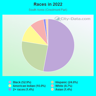
- 9,21952.9%Black
- 4,29324.6%Hispanic or Latino
- 1,90510.9%American Indian
- 1,5178.7%White
- 2491.4%Asian
- 2521.4%Two or more races
Distribution of median household income
![Distribution of median household income]()
- 705Less than $10,000
- 1,260$10,000 to $19,999
- 323$20,000 to $29,999
- 735$30,000 to $39,999
- 318$40,000 to $49,999
- 518$50,000 to $59,999
- 457$60,000 to $74,999
- 597$75,000 to $99,999
- 915$100,000 to $124,999
- 412$125,000 to $149,999
- 472$150,000 to $199,999
- 951$200,000 or more

Distribution of owner-occupied house/condo value
![Distribution of owner-occupied house/condo value]()
- 1,322Less than $50,000
- 2,668$50,000 to $99,999
- 1,066$100,000 to $149,999
- 604$150,000 to $199,999
- 42$200,000 to $249,999
- 365$250,000 to $299,999
- 62$300,000 to $399,999
- 217$400,000 to $499,999
- 123$500,000 to $749,999

Distribution of rent paid by renters
![Distribution of rent paid by renters]()
- 668Less than $100
- 439$100 to $199
- 907$200 to $299
- 801$300 to $399
- 215$400 to $499
- 71$500 to $599
- 500$600 to $699
- 509$700 to $799
- 307$800 to $899
- 299$900 to $999
- 991$1,000 to $1,249
- 794$1,250 to $1,499
- 671$1,500 to $1,999
- 642$2,000 or more

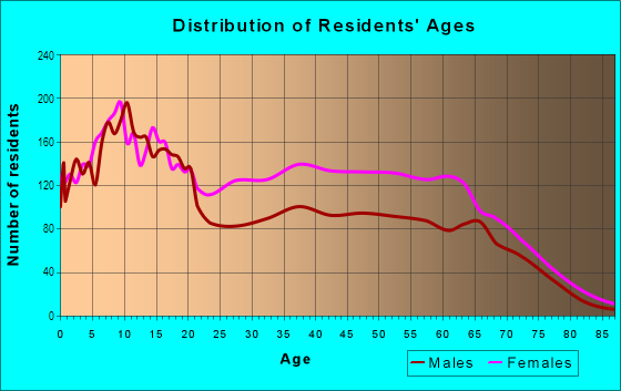
| Males: | 7,205 |
| Females: | 7,200 |
Males:
| This neighborhood: | 26.6 years |
| Whole city: | 34.4 years |
| This neighborhood: | 43.2 years |
| Whole city: | 34.7 years |
Average household size:
| South Acres (Crestmont Parl): | 19.2 people |
| Houston: | 2.4 people |
Percentage of family households:
| South Acres (Crestmont Parl): | 43.6% |
| Houston: | 43.0% |
| Here: | 34.6% |
| Houston: | 34.7% |
Percentage of married-couple families with children (among all households):
| South Acres (Crestmont Parl): | 19.8% |
| Houston: | 23.3% |
Percentage of single-mother households (among all households):
| South Acres (Crestmont Parl): | 37.3% |
| Houston: | 13.9% |
Percentage of never married males 15 years old and over:
Percentage of never married females 15 years old and over:
| South Acres (Crestmont Parl): | 14.4% |
| Houston: | 22.9% |
Percentage of never married females 15 years old and over:
| South Acres (Crestmont Parl): | 17.2% |
| city: | 21.2% |
Percentage of people that speak English not well or not at all:
| South Acres (Crestmont Parl): | 5.4% |
| Houston: | 15.9% |
Percentage of people born in this state:
Percentage of people born in another U.S. state:
Percentage of native residents but born outside the U.S.:
Percentage of foreign born residents:
| Here: | 79.1% |
| Houston: | 51.1% |
Percentage of people born in another U.S. state:
| South Acres (Crestmont Parl): | 9.5% |
| Houston: | 17.7% |
Percentage of native residents but born outside the U.S.:
| Here: | 0.5% |
| city: | 1.8% |
Percentage of foreign born residents:
| Here: | 11.0% |
| Houston: | 29.4% |
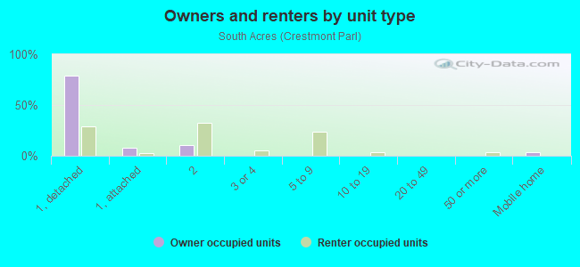
Owner-occupied
Renter-occupied

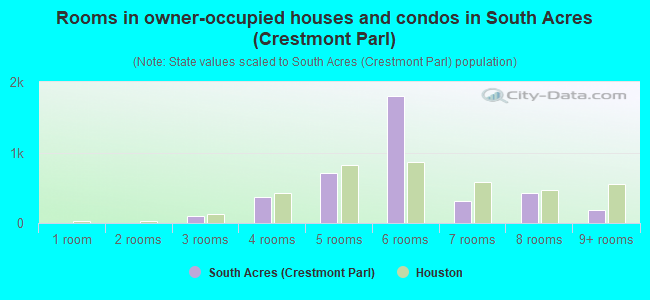
- Rooms in owner-occupied houses and condos in South Acres <
> - 01 room
- 02 rooms
- 933 rooms
- 3634 rooms
- 7145 rooms
- 1,7966 rooms
- 3117 rooms
- 4258 rooms
- 1829+ rooms
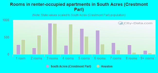
- Rooms in renter-occupied apartments in South Acres <
> - 2821 room
- 1882 rooms
- 9073 rooms
- 2614 rooms
- 7505 rooms
- 7056 rooms
- 3427 rooms
- 2798 rooms
- 1159+ rooms
Owner-occupied
Renter-occupied
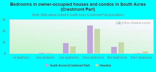
- Bedrooms in owner-occupied houses and condos in South Acres <
> - 0no bedroom
- 931 bedroom
- 9622 bedrooms
- 2,5203 bedrooms
- 6094 bedrooms
- 615+ bedrooms
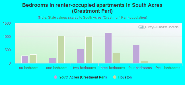
- Bedrooms in renter-occupied apartments in South Acres <
> - 282no bedroom
- 2041 bedroom
- 5402 bedrooms
- 1,1513 bedrooms
- 6774 bedrooms
- 05+ bedrooms
Average number of cars or other vehicles available in houses/condos:
Average number of cars or other vehicles available in apartments:
| This neighborhood: | |
| Houston: |
Average number of cars or other vehicles available in apartments:
| Here: | 1.3 |
| city: | 1.3 |
Percentage of units with a mortgage:
| South Acres (Crestmont Parl): | 29.5% |
| Houston: | 50.8% |
Average estimated value of detached houses in 2022 (86.4% of all units):
| South Acres (Crestmont Parl): | $75,384 |
| Houston: | $368,067 |
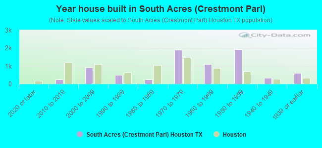
- Year house built in South Acres <
> - 02020 or later
- 2462010 to 2019
- 9062000 to 2009
- 4841990 to 1999
- 2561980 to 1989
- 1,8891970 to 1979
- 1,1071960 to 1969
- 1,9251950 to 1959
- 3441940 to 1949
- 6171939 or earlier
City-data.com crime index for city in 2020 (higher means more crime):
| City: | 560.9 |
| U.S. average: | 219.5 |
Travel time to work (commute)
![Travel time to work (commute)]()
- 308Less than 5 minutes
- 1155 to 9 minutes
- 30710 to 14 minutes
- 31115 to 19 minutes
- 1,01820 to 24 minutes
- 69125 to 29 minutes
- 1,73630 to 34 minutes
- 42735 to 39 minutes
- 30740 to 44 minutes
- 54545 to 59 minutes
- 32160 to 89 minutes
- 85390 or more minutes

Means of transportation to work
![Means of transportation to work]()
- 84.2%4,326Drove a car alone
- 10.0%512Carpooled
- 6.2%319Bus
- 0.5%28Subway or elevated rail
- 17.8%916Light rail, streetcar or trolley
- 2.3%116Walked
- 22.7%1,164Other means
- 2.9%149Worked at home

Time leaving home to go to work
![Time leaving home to go to work]()
- 59212:00 a.m. to 4:59 a.m.
- 2735:00 a.m. to 5:29 a.m.
- 4455:30 a.m. to 5:59 a.m.
- 7266:00 a.m. to 6:29 a.m.
- 8186:30 a.m. to 6:59 a.m.
- 1,5757:00 a.m. to 7:29 a.m.
- 4037:30 a.m. to 7:59 a.m.
- 5448:00 a.m. to 8:29 a.m.
- 6018:30 a.m. to 8:59 a.m.
- 2039:00 a.m. to 9:59 a.m.
- 7110:00 a.m. to 10:59 a.m.
- 4611:00 a.m. to 11:59 a.m.
- 38912:00 p.m. to 3:59 p.m.
- 3984:00 p.m. to 11:59 p.m.

Occupations of males:
- Percentage of males in business and financial operations occupations:
Here: 11.3% city: 5.4%
- Percentage of males in service occupations:
Here: 9.7% city: 12.9%
- Percentage of males in sales and office occupations:
Here: 32.0% city: 13.5%
- Percentage of males in construction, extraction, and maintenance occupations:
Here: 26.3% city: 15.7%
- Percentage of males in production occupations:
Here: 2.9% city: 6.0%
- Percentage of males in transportation occupations:
Here: 1.1% city: 6.1%
- Percentage of males in material moving occupations:
Here: 8.5% city: 5.4%
Occupations of females:
- Percentage of females in management occupations (except farmers):
Here: 4.3% city: 8.6%
- Percentage of females in business and financial operations occupations:
Here: 3.0% city: 6.8%
- Percentage of females in community and social services occupations:
Here: 7.6% city: 1.8%
- Percentage of females in legal occupations:
Here: 6.2% city: 2.0%
- Percentage of females in education, training, and library occupations:
Here: 8.9% city: 8.5%
- Percentage of females in service occupations:
Here: 29.2% city: 23.8%
- Percentage of females in sales and office occupations:
Here: 19.9% city: 26.6%
- Percentage of females in production occupations:
Here: 10.7% city: 2.6%
- Percentage of females in transportation occupations:
Here: 6.6% city: 1.2%
- Percentage of females in material moving occupations:
Here: 3.3% city: 2.5%
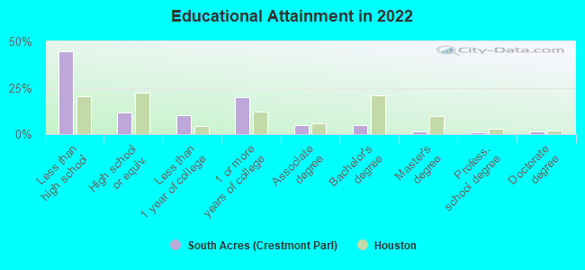
Education in this neighborhood (subdivision or community):
- Percentage of people 3 years and older in K-12 schools:
South Acres (Crestmont Parl): 33.9% Houston: 16.6%
- Percentage of people 3 years and older in undergraduate colleges:
South Acres (Crestmont Parl): 5.4% Houston: 4.6%
- Percentage of people 3 years and older in grad. or professional schools:
South Acres (Crestmont Parl): 0.9% Houston: 1.6%
- Percentage of students K-12 enrolled in private schools:
South Acres (Crestmont Parl): 54.2% Houston: 9.0%
Percentage of population below poverty level:
| South Acres (Crestmont Parl): | 35.3% |
| Houston: | 20.7% |
Percentage of married-couple families with both working:
| South Acres (Crestmont Parl): | 162.0% |
| Houston: | 54.9% |
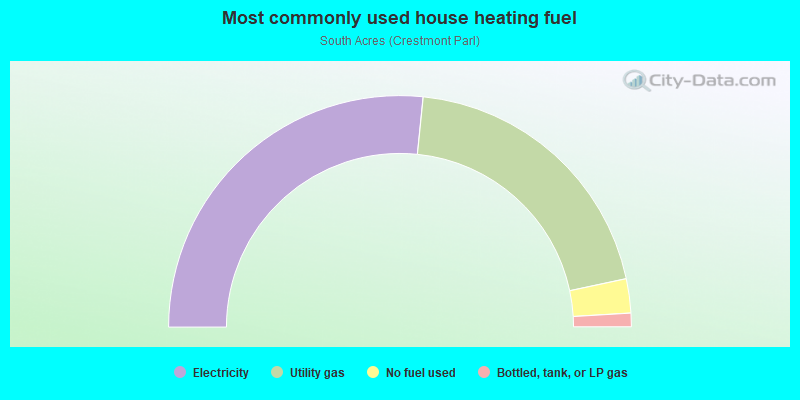
- 53.2%Electricity
- 40.1%Utility gas
- 4.8%No fuel used
- 1.9%Bottled, tank, or LP gas
Highways in this neighborhood:
South Fwy (State Hwy 288)
Length: 0.57 miles
Direction: N-S
Direction: N-S
Roads and streets:
Cullen Blvd (Co Rd 865)
Length: 4.68 miles
Direction: N-S
Address range: 10196 to 13599
Direction: N-S
Address range: 10196 to 13599
Almeda-Genoa Rd
Length: 3.56 miles
Directions: E-W, SW-NE
Address range: 2500 to 5598
Directions: E-W, SW-NE
Address range: 2500 to 5598
S Acres Dr
Length: 2.68 miles
Directions: E-W, N-S, SE-NW
Address range: 3700 to 5956
Directions: E-W, N-S, SE-NW
Address range: 3700 to 5956
Airport Blvd
Length: 2.39 miles
Directions: E-W, SE-NW
Address range: 4100 to 6021
Directions: E-W, SE-NW
Address range: 4100 to 6021
Swingle Rd
Length: 2.29 miles
Directions: E-W, N-S, SW-NE
Address range: 3700 to 4699
Directions: E-W, N-S, SW-NE
Address range: 3700 to 4699
Selinsky Rd
Length: 1.94 miles
Direction: E-W
Address range: 4700 to 5933
Direction: E-W
Address range: 4700 to 5933
Fuqua St
Length: 1.71 miles
Direction: E-W
Address range: 2900 to 4099
Direction: E-W
Address range: 2900 to 4099
Kilkenny Dr
Length: 1.65 miles
Directions: E-W, N-S, SW-NE
Address range: 3500 to 5399
Directions: E-W, N-S, SW-NE
Address range: 3500 to 5399
Leitrim Way
Length: 1.51 miles
Direction: N-S
Address range: 10500 to 12999
Direction: N-S
Address range: 10500 to 12999
Furman Rd
Length: 1.48 miles
Direction: N-S
Address range: 12405 to 14098
Direction: N-S
Address range: 12405 to 14098
Tavenor Ln
Length: 1.48 miles
Direction: E-W
Address range: 3900 to 5499
Direction: E-W
Address range: 3900 to 5499
Donegal Way
Length: 1.38 miles
Direction: N-S
Address range: 10600 to 13299
Direction: N-S
Address range: 10600 to 13299
Fairgreen Ln
Length: 1.33 miles
Directions: E-W, N-S
Address range: 4100 to 5499
Directions: E-W, N-S
Address range: 4100 to 5499
Segrest Dr
Length: 1.27 miles
Direction: N-S
Address range: 10700 to 13599
Direction: N-S
Address range: 10700 to 13599
Webercrest Rd
Length: 1.15 miles
Direction: N-S
Address range: 11400 to 12999
Direction: N-S
Address range: 11400 to 12999
E Orem Dr
Length: 1.13 miles
Directions: E-W, SE-NW
Address range: 4600 to 5399
Directions: E-W, SE-NW
Address range: 4600 to 5399
Murr Way
Length: 1.10 miles
Direction: N-S
Address range: 10500 to 12899
Direction: N-S
Address range: 10500 to 12899
Madden Ln
Length: 1.07 miles
Direction: E-W
Address range: 3900 to 5499
Direction: E-W
Address range: 3900 to 5499
Scott St
Length: 1.01 miles
Direction: N-S
Address range: 11500 to 13599
Direction: N-S
Address range: 11500 to 13599
Botany Ln
Length: 1.01 miles
Direction: E-W
Address range: 3700 to 5499
Direction: E-W
Address range: 3700 to 5499
Glen Hollow Dr
Length: 1.00 miles
Directions: E-W, N-S, SW-NE
Address range: 10800 to 12913
Directions: E-W, N-S, SW-NE
Address range: 10800 to 12913
Bungalow Ln
Length: 0.93 miles
Direction: E-W
Address range: 4300 to 14450
Direction: E-W
Address range: 4300 to 14450
Roandale Dr
Length: 0.92 miles
Directions: E-W, N-S, SE-NW
Address range: 10300 to 12899
Directions: E-W, N-S, SE-NW
Address range: 10300 to 12899
Holloway Dr
Length: 0.90 miles
Direction: E-W
Address range: 4100 to 5099
Direction: E-W
Address range: 4100 to 5099
Dumore Dr
Length: 0.90 miles
Directions: E-W, SE-NW
Address range: 4900 to 5699
Directions: E-W, SE-NW
Address range: 4900 to 5699
Martin Luther King Jr Blvd
Length: 0.87 miles
Directions: N-S, SW-NE
Address range: 10600 to 10999
Directions: N-S, SW-NE
Address range: 10600 to 10999
Sandrock Dr
Length: 0.87 miles
Directions: N-S, SE-NW
Address range: 11400 to 12899
Directions: N-S, SE-NW
Address range: 11400 to 12899
Duane St
Length: 0.85 miles
Directions: N-S, SE-NW, SW-NE
Address range: 10600 to 12099
Directions: N-S, SE-NW, SW-NE
Address range: 10600 to 12099
Bay Cedar Dr
Length: 0.85 miles
Directions: E-W, N-S, SE-NW
Address range: 10900 to 12818
Directions: E-W, N-S, SE-NW
Address range: 10900 to 12818
Orem Dr
Length: 0.84 miles
Direction: E-W
Address range: 3900 to 4599
Direction: E-W
Address range: 3900 to 4599
Park Village Dr
Length: 0.78 miles
Direction: E-W
Address range: 5130 to 5649
Direction: E-W
Address range: 5130 to 5649
Cork Dr
Length: 0.76 miles
Directions: E-W, N-S
Address range: 3500 to 4099
Directions: E-W, N-S
Address range: 3500 to 4099
Rockford Dr
Length: 0.72 miles
Direction: N-S
Address range: 11000 to 12999
Direction: N-S
Address range: 11000 to 12999
S Park Blvd (Martin Luther King Jr Blvd)
Length: 0.71 miles
Directions: N-S, SW-NE
Address range: 11000 to 12199
Directions: N-S, SW-NE
Address range: 11000 to 12199
Howcher St
Length: 0.68 miles
Directions: E-W, SW-NE
Address range: 4100 to 5199
Directions: E-W, SW-NE
Address range: 4100 to 5199
Panay Dr
Length: 0.67 miles
Directions: E-W, N-S, SW-NE
Address range: 10900 to 12899
Directions: E-W, N-S, SW-NE
Address range: 10900 to 12899
Jutland Rd
Length: 0.66 miles
Directions: E-W, N-S
Address range: 10900 to 12899
Directions: E-W, N-S
Address range: 10900 to 12899
Greylog Dr
Length: 0.64 miles
Directions: E-W, N-S, SE-NW
Address range: 5200 to 5699
Directions: E-W, N-S, SE-NW
Address range: 5200 to 5699
Brisbane St
Length: 0.64 miles
Direction: E-W
Address range: 4100 to 5099
Direction: E-W
Address range: 4100 to 5099
Southview St
Length: 0.62 miles
Directions: E-W, N-S
Address range: 10500 to 12099
Directions: E-W, N-S
Address range: 10500 to 12099
Groton Dr
Length: 0.60 miles
Direction: E-W
Address range: 3700 to 4499
Direction: E-W
Address range: 3700 to 4499
Canterway Dr
Length: 0.56 miles
Directions: E-W, SW-NE
Address range: 5200 to 5699
Directions: E-W, SW-NE
Address range: 5200 to 5699
Rubin St
Length: 0.56 miles
Direction: N-S
Address range: 10600 to 12599
Direction: N-S
Address range: 10600 to 12599
Claygate Dr
Length: 0.56 miles
Directions: E-W, N-S
Address range: 12400 to 12999
Directions: E-W, N-S
Address range: 12400 to 12999
Hickok Ln
Length: 0.56 miles
Direction: E-W
Address range: 3800 to 4399
Direction: E-W
Address range: 3800 to 4399
Sandhurst Dr
Length: 0.54 miles
Directions: N-S, SW-NE
Address range: 11300 to 12899
Directions: N-S, SW-NE
Address range: 11300 to 12899
Mowery Rd
Length: 0.54 miles
Direction: E-W
Address range: 4000 to 4599
Direction: E-W
Address range: 4000 to 4599
Hartsville Rd
Length: 0.53 miles
Direction: E-W
Address range: 4000 to 4599
Direction: E-W
Address range: 4000 to 4599
Denoron Dr
Length: 0.52 miles
Directions: E-W, SE-NW
Address range: 4900 to 5699
Directions: E-W, SE-NW
Address range: 4900 to 5699
Grace Point Ln
Length: 0.51 miles
Directions: E-W, N-S, SE-NW
Address range: 5200 to 5699
Directions: E-W, N-S, SE-NW
Address range: 5200 to 5699
Dacca Dr
Length: 0.51 miles
Direction: E-W
Address range: 4100 to 4599
Direction: E-W
Address range: 4100 to 4599
S Coast Dr
Length: 0.47 miles
Directions: E-W, N-S
Address range: 12400 to 12999
Directions: E-W, N-S
Address range: 12400 to 12999
Mosscrest Dr
Length: 0.46 miles
Directions: N-S, SE-NW
Address range: 10900 to 12825
Directions: N-S, SE-NW
Address range: 10900 to 12825
Marchant Rd
Length: 0.46 miles
Directions: E-W, N-S, SW-NE
Address range: 3600 to 4399
Directions: E-W, N-S, SW-NE
Address range: 3600 to 4399
Fawnway Dr
Length: 0.45 miles
Directions: E-W, N-S
Address range: 11400 to 12899
Directions: E-W, N-S
Address range: 11400 to 12899
Fellows Rd
Length: 0.45 miles
Direction: E-W
Address range: 2228 to 2249
Direction: E-W
Address range: 2228 to 2249
Paradise Ln
Length: 0.44 miles
Directions: E-W, SW-NE
Address range: 4700 to 5099
Directions: E-W, SW-NE
Address range: 4700 to 5099
Akard St
Length: 0.43 miles
Directions: E-W, SE-NW
Address range: 4100 to 4499
Directions: E-W, SE-NW
Address range: 4100 to 4499
Hycohen Rd
Length: 0.43 miles
Direction: N-S
Address range: 13600 to 13799
Direction: N-S
Address range: 13600 to 13799
Lockcrest St
Length: 0.43 miles
Directions: E-W, SW-NE
Address range: 2900 to 3127
Directions: E-W, SW-NE
Address range: 2900 to 3127
Greenshire Dr
Length: 0.43 miles
Directions: N-S, SE-NW, SW-NE
Address range: 11600 to 12899
Directions: N-S, SE-NW, SW-NE
Address range: 11600 to 12899
Friar Point Rd
Length: 0.42 miles
Direction: E-W
Address range: 4100 to 4499
Direction: E-W
Address range: 4100 to 4499
Cedarburg Dr
Length: 0.39 miles
Directions: N-S, SE-NW
Address range: 5500 to 5665
Directions: N-S, SE-NW
Address range: 5500 to 5665
Tareyton Ln
Length: 0.38 miles
Direction: E-W
Address range: 4100 to 4499
Direction: E-W
Address range: 4100 to 4499
Cape Hyannis Dr
Length: 0.38 miles
Directions: E-W, N-S, SW-NE
Address range: 11700 to 12899
Directions: E-W, N-S, SW-NE
Address range: 11700 to 12899
Meadow Park Dr
Length: 0.35 miles
Directions: E-W, SW-NE
Address range: 4700 to 4999
Directions: E-W, SW-NE
Address range: 4700 to 4999
Elm Spring Dr
Length: 0.33 miles
Directions: N-S, SE-NW
Address range: 5500 to 5699
Directions: N-S, SE-NW
Address range: 5500 to 5699
N 8th St
Length: 0.33 miles
Direction: N-S
Address range: 10800 to 11399
Direction: N-S
Address range: 10800 to 11399
Blarney Dr
Length: 0.31 miles
Direction: E-W
Address range: 3500 to 3999
Direction: E-W
Address range: 3500 to 3999
Land Rd
Length: 0.31 miles
Direction: N-S
Address range: 13200 to 13299
Direction: N-S
Address range: 13200 to 13299
Richfield Ln
Length: 0.31 miles
Directions: E-W, SW-NE
Address range: 4900 to 5199
Directions: E-W, SW-NE
Address range: 4900 to 5199
Lockgate Ln
Length: 0.30 miles
Directions: E-W, N-S, SW-NE
Address range: 10900 to 11599
Directions: E-W, N-S, SW-NE
Address range: 10900 to 11599
Murdock St
Length: 0.29 miles
Direction: E-W
Address range: 3500 to 3709
Direction: E-W
Address range: 3500 to 3709
Southspring Dr
Length: 0.28 miles
Direction: N-S
Address range: 12600 to 12999
Direction: N-S
Address range: 12600 to 12999
Southbridge Rd
Length: 0.28 miles
Direction: N-S
Address range: 12600 to 12999
Direction: N-S
Address range: 12600 to 12999
Elm Tree Dr
Length: 0.28 miles
Directions: N-S, SE-NW
Address range: 5500 to 5699
Directions: N-S, SE-NW
Address range: 5500 to 5699
Mill Valley Rd
Length: 0.28 miles
Directions: E-W, N-S
Address range: 11700 to 12899
Directions: E-W, N-S
Address range: 11700 to 12899
Sugar Bush Dr
Length: 0.28 miles
Direction: E-W
Address range: 5200 to 5399
Direction: E-W
Address range: 5200 to 5399
Safeguard St
Length: 0.27 miles
Directions: E-W, N-S, SE-NW, SW-NE
Address range: 10600 to 12599
Directions: E-W, N-S, SE-NW, SW-NE
Address range: 10600 to 12599
Scenic Dr
Length: 0.26 miles
Directions: E-W, N-S, SE-NW, SW-NE
Address range: 4720 to 4803
Directions: E-W, N-S, SE-NW, SW-NE
Address range: 4720 to 4803
Stoneham Ave (Stonham St)
Length: 0.26 miles
Direction: E-W
Address range: 3500 to 3699
Direction: E-W
Address range: 3500 to 3699
Osprey Dr
Length: 0.26 miles
Direction: E-W
Address range: 5400 to 5599
Direction: E-W
Address range: 5400 to 5599
Alderfer St
Length: 0.25 miles
Direction: E-W
Address range: 3500 to 3699
Direction: E-W
Address range: 3500 to 3699
Sorsby Way
Length: 0.24 miles
Direction: N-S
Address range: 10600 to 12599
Direction: N-S
Address range: 10600 to 12599
Palisade Dr
Length: 0.24 miles
Direction: E-W
Address range: 4700 to 4899
Direction: E-W
Address range: 4700 to 4899
Pembroke St
Length: 0.24 miles
Direction: N-S
Address range: 12800 to 13099
Direction: N-S
Address range: 12800 to 13099
Russelville Rd
Length: 0.23 miles
Direction: E-W
Direction: E-W
Hunkler Dr
Length: 0.22 miles
Directions: N-S, SE-NW, SW-NE
Address range: 10600 to 11999
Directions: N-S, SE-NW, SW-NE
Address range: 10600 to 11999
Kennedy Heights Blvd
Length: 0.22 miles
Direction: E-W
Address range: 4600 to 4849
Direction: E-W
Address range: 4600 to 4849
9th
Length: 0.22 miles
Direction: N-S
Direction: N-S
Redfern Dr
Length: 0.21 miles
Direction: N-S
Address range: 12100 to 12899
Direction: N-S
Address range: 12100 to 12899
Anna Held St
Length: 0.21 miles
Direction: N-S
Address range: 10503 to 10799
Direction: N-S
Address range: 10503 to 10799
Carlson Ln
Length: 0.20 miles
Directions: E-W, N-S, SW-NE
Address range: 3700 to 3999
Directions: E-W, N-S, SW-NE
Address range: 3700 to 3999
Kildare Dr
Length: 0.20 miles
Direction: E-W
Address range: 3700 to 3828
Direction: E-W
Address range: 3700 to 3828
Hiford Dr
Length: 0.20 miles
Direction: E-W
Address range: 3700 to 3899
Direction: E-W
Address range: 3700 to 3899
Faircroft Dr
Length: 0.20 miles
Directions: N-S, SW-NE
Address range: 10600 to 10999
Directions: N-S, SW-NE
Address range: 10600 to 10999
Carlton Dr
Length: 0.20 miles
Direction: N-S
Address range: 10800 to 11099
Direction: N-S
Address range: 10800 to 11099
Long Gate Dr
Length: 0.20 miles
Direction: N-S
Address range: 10800 to 11099
Direction: N-S
Address range: 10800 to 11099
Honeyvine Dr
Length: 0.18 miles
Direction: E-W
Address range: 5200 to 5399
Direction: E-W
Address range: 5200 to 5399
Fawngrove Dr
Length: 0.15 miles
Direction: N-S
Address range: 11300 to 11599
Direction: N-S
Address range: 11300 to 11599
Edgar St
Length: 0.13 miles
Direction: N-S
Address range: 10600 to 11999
Direction: N-S
Address range: 10600 to 11999
Rosecroft Dr
Length: 0.13 miles
Direction: N-S
Address range: 10400 to 11599
Direction: N-S
Address range: 10400 to 11599
Scott
Length: 0.12 miles
Directions: E-W, N-S
Directions: E-W, N-S
Pembroke
Length: 0.11 miles
Directions: E-W, N-S
Directions: E-W, N-S
Glenhollow Dr
Length: 0.10 miles
Direction: N-S
Direction: N-S
Rosewin Cir
Length: 0.09 miles
Direction: E-W
Address range: 4000 to 4099
Direction: E-W
Address range: 4000 to 4099
Redwin Cir
Length: 0.08 miles
Direction: E-W
Address range: 4000 to 4099
Direction: E-W
Address range: 4000 to 4099
Winthrop St
Length: 0.08 miles
Directions: E-W, N-S, SE-NW
Address range: 3700 to 3899
Directions: E-W, N-S, SE-NW
Address range: 3700 to 3899
Silver Stone St
Length: 0.06 miles
Direction: N-S
Address range: 10600 to 10699
Direction: N-S
Address range: 10600 to 10699
Shorehaven Cir
Length: 0.06 miles
Direction: E-W
Address range: 5000 to 5099
Direction: E-W
Address range: 5000 to 5099
Holloway St
Length: 0.05 miles
Directions: E-W, SW-NE
Directions: E-W, SW-NE
Martin Luther King Blvd
Length: 0.05 miles
Direction: N-S
Direction: N-S
Deluxe St
Length: 0.05 miles
Direction: N-S
Address range: 13500 to 13599
Direction: N-S
Address range: 13500 to 13599
Neon St
Length: 0.05 miles
Direction: N-S
Address range: 13500 to 13599
Direction: N-S
Address range: 13500 to 13599
Cresthaven Cir
Length: 0.04 miles
Direction: E-W
Address range: 5000 to 5099
Direction: E-W
Address range: 5000 to 5099
Denoron Ct
Length: 0.04 miles
Direction: SW-NE
Address range: 5100 to 5135
Direction: SW-NE
Address range: 5100 to 5135
Bay Cedar Ct
Length: 0.03 miles
Direction: E-W
Address range: 5000 to 5099
Direction: E-W
Address range: 5000 to 5099
Cedarburg Cir
Length: 0.03 miles
Direction: SW-NE
Direction: SW-NE
Russelville Dr
Length: 0.03 miles
Direction: E-W
Direction: E-W
Sabra Ct
Length: 0.03 miles
Direction: N-S
Address range: 2 to 4899
Direction: N-S
Address range: 2 to 4899
Holloway Ct
Length: 0.03 miles
Direction: N-S
Address range: 2 to 4799
Direction: N-S
Address range: 2 to 4799
Other features:
Sims Byu
Length: 0.15 miles
Directions: E-W, SW-NE
Directions: E-W, SW-NE