Bridge Statistics for Bonita, California (CA)
Condition, Traffic, Stress, Structural Evaluation, Project Costs
- National Bridge Inventory (NBI) Statistics
- 14Number of bridges
- 128ft / 39.4mTotal length
- 166,469Total average daily traffic
- 1,227Total average daily truck traffic
- National Bridge Inventory (NBI) Registered Bridges for Bonita
- No street view available for this location
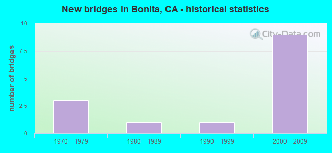
- New bridges - historical statistics
- 31970-1979
- 11980-1989
- 11990-1999
- 92000-2009


- Bridge Condition - Superstructure
- 75.0%Good
- 25.0%Fair

- Bridge Condition - Substructure
- 75.0%Good
- 25.0%Fair

- Bridge Condition - Channel
- 50.0%Very good
- 33.3%Good
- 16.7%Satisfactory

- Bridge Condition - Culverts
- 80.0%Good
- 20.0%Satisfactory
Find on map >> Show street view
Structure Number: 57 1173R, Location: 11-SD-054-6.00 (Lat: 32.690961, Lng: -117.017208), Route carried "on" structure: State highway 54, Year Built: 2007, Status: Open, Structure Length: 7.65m (25.10ft), Average Daily Traffic: 44,500 (year 2012), Average Future Daily Traffic: 63,500 (year 2040), Design Load: HS 20+Mod, Features Intersected: SWEETWATER RD & W54-S125
Minimum Vertical Clearance: 30+ m (98+ ft), Kilometerpoint: 6.000, Lanes on structure: 3, Lanes under structure: 3, Base Highway Network: Yes (, Subroute: 1), Owner: State Highway Agency, Approaching Roadway Width: 16.8m (55.1ft), Skew: 3 degrees, Material/Design: Prestressed concrete continuous, Design/Construction: Box Beam or Girders - Multiple, Number Of Spans In Main Unit: 2, Length of Maximum Span: 39.8m (130.6ft), Curb-To-Curb Width: 16.8m (55.1ft), Out-to-Out Width: 17.7m (58.1ft)
Condition: Deck: Fair, Superstructure: Good, Substructure: Fair, Operating Rating: 54.1 metric tons, Method Used To Determine Operating Rating: Assigned rating based on Load Factor Design (LFD) reported in metric tons, Inventory Rating: 32.4 metric tons, Method Used To Determine Inventory Rating: Assigned rating based on Load Factor Design (LFD) reported in metric tons, Structural Evaluation: Somewhat better than minimum adequacy, Deck Geometry: Equal to present minimum criteria, Underclear: Somewhat better than minimum adequacy, Approach Roadway Alignment: Equal to present desirable criteria, Designated Inspection Frequency: Every 24 months, Inspection Date: June 2020, Deck Structure Type: Concrete Cast-file-Place
Find on map >> Show street view
Structure Number: 57 1175L, Location: 11-SD-125-7.39 (Lat: 32.681731, Lng: -116.997697), Route carried "on" structure: State highway 125, Year Built: 2008, Status: Open, Structure Length: 4.75m (15.58ft), Average Daily Traffic: 34,000 (year 2018), Truck Traffic: 1%, Average Future Daily Traffic: 35,000 (year 2037), Design Load: HS 20+Mod, Features Intersected: SUMMIT MEADOW RD
Minimum Vertical Clearance: 30+ m (98+ ft), Kilometerpoint: 7.390, Lanes on structure: 2, Lanes under structure: 2, Base Highway Network: Yes, Owner: State Highway Agency, Approaching Roadway Width: 11.7m (38.4ft), Material/Design: Prestressed concrete, Design/Construction: Box Beam or Girders - Multiple, Number Of Spans In Main Unit: 1, Length of Maximum Span: 47.5m (155.8ft), Curb-To-Curb Width: 11.7m (38.4ft), Out-to-Out Width: 12.6m (41.3ft)
Condition: Deck: Fair, Superstructure: Good, Substructure: Good, Operating Rating: 54.1 metric tons, Method Used To Determine Operating Rating: Assigned rating based on Load Factor Design (LFD) reported in metric tons, Inventory Rating: 32.4 metric tons, Method Used To Determine Inventory Rating: Assigned rating based on Load Factor Design (LFD) reported in metric tons, Structural Evaluation: Better than present minimum criteria, Deck Geometry: Equal to present minimum criteria, Underclear: Somewhat better than minimum adequacy, Approach Roadway Alignment: Equal to present desirable criteria, Designated Inspection Frequency: Every 24 months, Inspection Date: June 2020, Deck Structure Type: Concrete Cast-file-Place
Find on map >> Show street view
Structure Number: 57 1175R, Location: 11-SD-125-7.39 (Lat: 32.682022, Lng: -116.998008), Route carried "on" structure: State highway 125, Year Built: 2008, Status: Open, Structure Length: 3.80m (12.47ft), Average Daily Traffic: 34,000 (year 2018), Truck Traffic: 1%, Average Future Daily Traffic: 35,000 (year 2037), Design Load: HS 20+Mod, Features Intersected: SUMMIT MEADOW RD
Minimum Vertical Clearance: 30+ m (98+ ft), Kilometerpoint: 7.390, Lanes on structure: 2, Lanes under structure: 2, Base Highway Network: Yes, Toll: On toll road, Owner: State Highway Agency, Approaching Roadway Width: 11.7m (38.4ft), Material/Design: Prestressed concrete, Design/Construction: Box Beam or Girders - Multiple, Number Of Spans In Main Unit: 1, Length of Maximum Span: 38.0m (124.7ft), Curb-To-Curb Width: 11.7m (38.4ft), Out-to-Out Width: 12.6m (41.3ft)
Condition: Deck: Fair, Superstructure: Good, Substructure: Good, Operating Rating: 54.1 metric tons, Method Used To Determine Operating Rating: Assigned rating based on Load Factor Design (LFD) reported in metric tons, Inventory Rating: 32.4 metric tons, Method Used To Determine Inventory Rating: Assigned rating based on Load Factor Design (LFD) reported in metric tons, Structural Evaluation: Better than present minimum criteria, Deck Geometry: Equal to present minimum criteria, Underclear: Equal to present minimum criteria, Approach Roadway Alignment: Equal to present desirable criteria, Designated Inspection Frequency: Every 24 months, Inspection Date: June 2020, Deck Structure Type: Concrete Cast-file-Place
Find on map >> Show street view
Structure Number: 57C0498, Location: 0.1MI S/O CENTRAL AVE (Lat: 32.666925, Lng: -117.023039), Route carried "on" structure: County highway , Year Built: 1972, Status: Open, Structure Length: 1.22m (4.00ft), Average Daily Traffic: 21,220 (year 2016), Truck Traffic: 1%, Average Future Daily Traffic: 21,519 (year 2038), Features Intersected: SWEETWATER RIV TRIBUTARY, Facility Carried by Structure: BONITA RD
Minimum Vertical Clearance: 30+ m (98+ ft), Kilometerpoint: 0.000, Lanes on structure: 3, Owner: County Highway Agency, Approaching Roadway Width: 13.7m (44.9ft), Skew: 4 degrees, Material/Design: Concrete, Design/Construction: Culvert, Number Of Spans In Main Unit: 3, Length of Maximum Span: 3.0m (9.8ft), Curb-To-Curb Width: 15.8m (51.8ft), Out-to-Out Width: 18.3m (60.0ft)
Condition: Channel: Good, Culverts: Good, Operating Rating: 40.5 metric tons, Method Used To Determine Operating Rating: Field evaluation and documented engineering judgment, Inventory Rating: 24.3 metric tons, Method Used To Determine Inventory Rating: Field evaluation and documented engineering judgment, Structural Evaluation: Equal to present minimum criteria, Deck Geometry: Better than present minimum criteria, Waterway Adequacy: Equal to present desirable criteria, Approach Roadway Alignment: Equal to present desirable criteria, Designated Inspection Frequency: Every 24 months, Inspection Date: May 2021
Find on map >> Show street view
Structure Number: 57C0504, Location: 240FT S/O SAN MIGUEL RD (Lat: 32.675969, Lng: -117.007603), Route carried "on" structure: County highway , Year Built: 1977, Status: Open, Structure Length: 0.88m (2.89ft), Average Daily Traffic: 233 (year 2010), Truck Traffic: 2%, Average Future Daily Traffic: 461 (year 2038), Features Intersected: SWEETWATER RIV TRIBUTARY, Facility Carried by Structure: LOMA DEL SOL DR
Minimum Vertical Clearance: 30+ m (98+ ft), Kilometerpoint: 0.000, Lanes on structure: 2, Owner: County Highway Agency, Approaching Roadway Width: 11.0m (36.1ft), Material/Design: Concrete, Design/Construction: Culvert, Number Of Spans In Main Unit: 3, Length of Maximum Span: 2.7m (8.9ft), Curb or Sidewalk Widths: Left: 0.3m (1.0ft), Right: 0.3m (1.0ft), Curb-To-Curb Width: 11.0m (36.1ft), Out-to-Out Width: 14.6m (47.9ft)
Condition: Channel: Very good, Culverts: Satisfactory, Operating Rating: 54.1 metric tons, Method Used To Determine Operating Rating: Field evaluation and documented engineering judgment, Inventory Rating: 32.4 metric tons, Method Used To Determine Inventory Rating: Field evaluation and documented engineering judgment, Structural Evaluation: Equal to present minimum criteria, Deck Geometry: Equal to present desirable criteria, Waterway Adequacy: Equal to present desirable criteria, Approach Roadway Alignment: Equal to present desirable criteria, Designated Inspection Frequency: Every 48 months, Inspection Date: May 2019
Find on map >> Show street view
Structure Number: 57C0634, Location: 375FT S/O CENTRAL AVE (Lat: 32.669058, Lng: -117.017311), Route carried "on" structure: County highway , Year Built: 1986, Status: Open, Structure Length: 0.98m (3.22ft), Average Daily Traffic: 1,367 (year 2016), Average Future Daily Traffic: 1,530 (year 2038), Features Intersected: SWEETWATER RIV TRIBUTARY, Facility Carried by Structure: DAWSONIA ST
Minimum Vertical Clearance: 30+ m (98+ ft), Kilometerpoint: 0.000, Lanes on structure: 2, Owner: County Highway Agency, Approaching Roadway Width: 11.6m (38.1ft), Material/Design: Concrete, Design/Construction: Culvert, Number Of Spans In Main Unit: 3, Length of Maximum Span: 3.0m (9.8ft), Curb or Sidewalk Widths: Left: 0.3m (1.0ft), Right: 1.2m (3.9ft), Curb-To-Curb Width: 11.6m (38.1ft), Out-to-Out Width: 13.4m (44.0ft)
Condition: Channel: Very good, Culverts: Good, Operating Rating: 54.1 metric tons, Method Used To Determine Operating Rating: Field evaluation and documented engineering judgment, Inventory Rating: 32.4 metric tons, Method Used To Determine Inventory Rating: Field evaluation and documented engineering judgment, Structural Evaluation: Better than present minimum criteria, Deck Geometry: Equal to present minimum criteria, Waterway Adequacy: Equal to present desirable criteria, Approach Roadway Alignment: Equal to present desirable criteria, Designated Inspection Frequency: Every 48 months, Inspection Date: May 2019, Deck Structure Type: Concrete Cast-file-Place, Wearing Surface/Protective System: Wearing Surface: Bituminous
Find on map >> Show street view
Structure Number: 57C0698, Location: 0.13MI S/O SWEETWATER RD (Lat: 32.674825, Lng: -117.016261), Route carried "on" structure: County highway , Year Built: 1997, Status: Open, Structure Length: 15.25m (50.03ft), Average Daily Traffic: 13,792 (year 2016), Truck Traffic: 1%, Average Future Daily Traffic: 14,555 (year 2038), Design Load: HS 20+Mod, Features Intersected: SWEETWATER RIVER, Facility Carried by Structure: BONITA ROAD
Minimum Vertical Clearance: 30+ m (98+ ft), Kilometerpoint: 0.000, Lanes on structure: 5, Owner: County Highway Agency, Approaching Roadway Width: 20.2m (66.3ft), Material/Design: Concrete continuous, Design/Construction: Slab, Number Of Spans In Main Unit: 8, Length of Maximum Span: 20.0m (65.6ft), Curb or Sidewalk Widths: Left: 1.5m (4.9ft), Right: 0.0m, Curb-To-Curb Width: 22.8m (74.8ft), Out-to-Out Width: 25.1m (82.3ft)
Condition: Deck: Fair, Superstructure: Fair, Substructure: Good, Channel: Very good, Operating Rating: 54.1 metric tons, Method Used To Determine Operating Rating: Assigned rating based on Load Factor Design (LFD) reported in metric tons, Inventory Rating: 32.4 metric tons, Method Used To Determine Inventory Rating: Assigned rating based on Load Factor Design (LFD) reported in metric tons, Structural Evaluation: Somewhat better than minimum adequacy, Deck Geometry: Equal to present minimum criteria, Waterway Adequacy: Equal to present desirable criteria, Approach Roadway Alignment: Equal to present desirable criteria, Designated Inspection Frequency: Every 24 months, Inspection Date: May 2021, Deck Structure Type: Concrete Cast-file-Place
Find on map >> Show street view
Structure Number: 57C0756, Location: 20FT E/O BRIARWOOD RD (Lat: 32.674789, Lng: -117.023900), Route carried "on" structure: City street , Year Built: 1974, Status: Open, Structure Length: 0.70m (2.30ft), Average Daily Traffic: 1,050 (year 2016), Truck Traffic: 3%, Average Future Daily Traffic: 1,576 (year 2038), Features Intersected: SWEETWATER RIVER TRIB., Facility Carried by Structure: SWEETWATER ROAD
Minimum Vertical Clearance: 30+ m (98+ ft), Kilometerpoint: 0.000, Lanes on structure: 2, Owner: County Highway Agency, Approaching Roadway Width: 11.0m (36.1ft), Skew: 3 degrees, Material/Design: Concrete continuous, Design/Construction: Culvert, Number Of Spans In Main Unit: 3, Length of Maximum Span: 1.8m (5.9ft), Curb-To-Curb Width: 9.5m (31.2ft), Out-to-Out Width: 11.3m (37.1ft)
Condition: Channel: Satisfactory, Culverts: Good, Operating Rating: 54.1 metric tons, Method Used To Determine Operating Rating: Field evaluation and documented engineering judgment, Inventory Rating: 32.4 metric tons, Method Used To Determine Inventory Rating: Field evaluation and documented engineering judgment, Structural Evaluation: Better than present minimum criteria, Deck Geometry: Somewhat better than minimum adequacy, Waterway Adequacy: Superior to present desirable criteria, Approach Roadway Alignment: Equal to present desirable criteria, Designated Inspection Frequency: Every 48 months, Inspection Date: May 2019
Find on map >> Show street view
Structure Number: 57C0776, Location: 0.5MI E/O BONITA ROAD (Lat: 32.671119, Lng: -117.013986), Route carried "on" structure: County highway , Year Built: 2008, Status: Open, Structure Length: 4.12m (13.52ft), Average Daily Traffic: 4,407 (year 2016), Truck Traffic: 1%, Average Future Daily Traffic: 5,327 (year 2038), Design Load: HS 20+Mod, Features Intersected: SWEETWATER RIVER TRIB, Facility Carried by Structure: CENTRAL AVENUE
Minimum Vertical Clearance: 30+ m (98+ ft), Kilometerpoint: 0.000, Lanes on structure: 3, Owner: County Highway Agency, Approaching Roadway Width: 13.1m (43.0ft), Skew: 4 degrees, Material/Design: Concrete continuous, Design/Construction: Culvert, Number Of Spans In Main Unit: 3, Length of Maximum Span: 6.9m (22.6ft), Curb or Sidewalk Widths: Left: 1.7m (5.6ft), Right: 2.3m (7.5ft), Curb-To-Curb Width: 13.1m (43.0ft), Out-to-Out Width: 17.6m (57.7ft)
Condition: Channel: Good, Culverts: Good, Operating Rating: 54.1 metric tons, Method Used To Determine Operating Rating: Field evaluation and documented engineering judgment, Inventory Rating: 32.4 metric tons, Method Used To Determine Inventory Rating: Field evaluation and documented engineering judgment, Structural Evaluation: Better than present minimum criteria, Deck Geometry: Meets minimum limits, Waterway Adequacy: Equal to present desirable criteria, Approach Roadway Alignment: Equal to present desirable criteria, Designated Inspection Frequency: Every 48 months, Inspection Date: May 2019
Find on map >> Show street view
Structure Number: 57 1173R, Location: 11-SD-054-6.00 (Lat: 32.690961, Lng: -117.017208), Route carried "under" structure: Ramp State highway 54, Year Built: 2007, Structure Length: 0. m, Average Daily Traffic: 2,000 (year 2012), Truck Traffic: 1%, Features Intersected: SWEETWATER RD & W54-S125
Minimum Vertical Clearance: 15.70m (51.51ft), Kilometerpoint: 6.000, Lanes on structure: 3, Lanes under structure: 1, Material/Design: Prestressed concrete continuous, Design/Construction: Box Beam or Girders - Multiple, Length of Maximum Span: 39.8m (130.6ft)
Find on map >> Show street view
Structure Number: 57 1173R, Location: 11-SD-054-6.00 (Lat: 32.690961, Lng: -117.017208), Route carried "under" structure: City street , Year Built: 2007, Structure Length: 0. m, Average Daily Traffic: 5,000 (year 2012), Truck Traffic: 1%, Features Intersected: SWEETWATER RD & W54-S125, Facility Carried by Structure: STATE ROUTE 54 EB
Minimum Vertical Clearance: 11.00m (36.09ft), Kilometerpoint: 0.000, Lanes on structure: 3, Lanes under structure: 2, Material/Design: Prestressed concrete continuous, Design/Construction: Box Beam or Girders - Multiple, Length of Maximum Span: 39.8m (130.6ft)
Find on map >> Show street view
Structure Number: 57 1175L, Location: 11-SD-125-7.39 (Lat: 32.681731, Lng: -116.997697), Route carried "under" structure: City street , Year Built: 2008, Structure Length: 0. m, Average Daily Traffic: 1,200 (year 2015), Truck Traffic: 1%, Features Intersected: SUMMIT MEADOW RD, Facility Carried by Structure: ROUTE 125 SB
Minimum Vertical Clearance: 10.00m (32.81ft), Kilometerpoint: 0.000, Lanes on structure: 2, Lanes under structure: 2, Material/Design: Prestressed concrete, Design/Construction: Box Beam or Girders - Multiple, Length of Maximum Span: 47.5m (155.8ft)
Find on map >> Show street view
Structure Number: 57 1175R, Location: 11-SD-125-7.39 (Lat: 32.682022, Lng: -116.998008), Route carried "under" structure: City street , Year Built: 2008, Structure Length: 0. m, Average Daily Traffic: 1,200 (year 2015), Truck Traffic: 1%, Features Intersected: SUMMIT MEADOW RD, Facility Carried by Structure: ROUTE 125 NB
Minimum Vertical Clearance: 8.26m (27.10ft), Kilometerpoint: 0.000, Lanes on structure: 2, Lanes under structure: 2, Material/Design: Prestressed concrete, Design/Construction: Box Beam or Girders - Multiple, Length of Maximum Span: 38.0m (124.7ft)
Find on map >> Show street view
Structure Number: 57 1176, Location: 11-SD-125-8.00 (Lat: 32.680947, Lng: -117.007833), Route carried "under" structure: State highway 125, Year Built: 2008, Structure Length: 0. m, Average Daily Traffic: 2,500 (year 2010), Truck Traffic: 1%, Features Intersected: STATE ROUTE 125, Facility Carried by Structure: PEDESTRIAN WALKWAY
Minimum Vertical Clearance: 7.67m (25.16ft), Kilometerpoint: 8.000, Lanes under structure: 4, Material/Design: Prestressed concrete, Design/Construction: Box Beam or Girders - Single/Spread, Length of Maximum Span: 42.5m (139.4ft)