Bridge Statistics for Bostonia, California (CA)
Condition, Traffic, Stress, Structural Evaluation, Project Costs
- National Bridge Inventory (NBI) Statistics
- 11Number of bridges
- 75ft / 23.5mTotal length
- 401,347Total average daily traffic
- 24,983Total average daily truck traffic
- National Bridge Inventory (NBI) Registered Bridges for Bostonia
- No street view available for this location
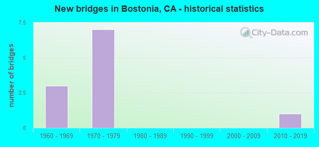
- New bridges - historical statistics
- 31960-1969
- 71970-1979
- 12010-2019


- Bridge Condition - Substructure
- 50.0%Good
- 50.0%Fair

- Bridge Condition - Channel
- 40.0%Excellent
- 20.0%Very good
- 20.0%Good
- 20.0%Fair

- Bridge Condition - Culverts
- 80.0%Good
- 20.0%Satisfactory
Find on map >> Show street view
Structure Number: 57 0552, Location: 11-SD-067-R1.12 (Lat: 32.819092, Lng: -116.960925), Route carried "on" structure: County highway S283, Year Built: 1966, Status: Open, Structure Length: 5.94m (19.49ft), Average Daily Traffic: 19,300 (year 2017), Truck Traffic: 6%, Average Future Daily Traffic: 25,405 (year 2039), Design Load: HS 20, Features Intersected: STATE ROUTE 67, Facility Carried by Structure: BRADLEY AVE
Minimum Vertical Clearance: 30+ m (98+ ft), Kilometerpoint: 0.000, Lanes on structure: 2, Lanes under structure: 6, Owner: State Highway Agency, Approaching Roadway Width: 11.3m (37.1ft), Material/Design: Concrete continuous, Design/Construction: Box Beam or Girders - Multiple, Number Of Spans In Main Unit: 2, Length of Maximum Span: 30.5m (100.1ft), Curb or Sidewalk Widths: Left: 1.5m (4.9ft), Right: 0.0m, Curb-To-Curb Width: 8.6m (28.2ft), Out-to-Out Width: 11.3m (37.1ft)
Condition: Deck: Good, Superstructure: Good, Substructure: Good, Operating Rating: 35.6 metric tons, Method Used To Determine Operating Rating: Load and Resistance Factor Rating (LRFR) rating reported by rating factor(RF) method using HL-93 loadings, Inventory Rating: 27.5 metric tons, Method Used To Determine Inventory Rating: Load and Resistance Factor Rating (LRFR) rating reported by rating factor(RF) method using HL-93 loadings, Structural Evaluation: Equal to present minimum criteria, Deck Geometry: High priority of replacement, Underclear: Meets minimum limits, Approach Roadway Alignment: Equal to present desirable criteria, Designated Inspection Frequency: Every 24 months, Inspection Date: August 2020, Deck Structure Type: Concrete Cast-file-Place
Find on map >> Show street view
Structure Number: 57 0714, Location: 11-SD-067-R1.28 (Lat: 32.821378, Lng: -116.960511), Route carried "on" structure: State highway 67, Year Built: 1966, Status: Open, Structure Length: 0.85m (2.79ft), Average Daily Traffic: 106,000 (year 2018), Truck Traffic: 7%, Average Future Daily Traffic: 129,400 (year 2040), Features Intersected: ALFRED DITCH
Minimum Vertical Clearance: 30+ m (98+ ft), Kilometerpoint: 1.280, Lanes on structure: 8, Base Highway Network: Yes (, Subroute: 1), Owner: State Highway Agency, Approaching Roadway Width: 49.1m (161.1ft), Skew: 21 degrees, Material/Design: Concrete, Design/Construction: Culvert, Number Of Spans In Main Unit: 3, Length of Maximum Span: 2.7m (8.9ft)
Condition: Channel: Very good, Culverts: Good, Operating Rating: 54.1 metric tons, Method Used To Determine Operating Rating: Field evaluation and documented engineering judgment, Inventory Rating: 32.4 metric tons, Method Used To Determine Inventory Rating: Field evaluation and documented engineering judgment, Structural Evaluation: Better than present minimum criteria, Waterway Adequacy: Equal to present desirable criteria, Approach Roadway Alignment: Equal to present desirable criteria, Designated Inspection Frequency: Every 48 months, Inspection Date: August 2020
Find on map >> Show street view
Structure Number: 57 0772, Location: 11-SD-067-R0.71 (Lat: 32.813264, Lng: -116.962611), Route carried "on" structure: City street S282, Year Built: 1971, Status: Open, Structure Length: 12.83m (42.09ft), Average Daily Traffic: 16,100 (year 2018), Truck Traffic: 4%, Average Future Daily Traffic: 18,485 (year 2040), Design Load: HS 20, Features Intersected: SR-67, MAGNOLIA, GRAVES, Facility Carried by Structure: GREENFIELD DRIVE
Minimum Vertical Clearance: 30+ m (98+ ft), Kilometerpoint: 0.000, Lanes on structure: 2, Lanes under structure: 11, Owner: State Highway Agency, Approaching Roadway Width: 12.7m (41.7ft), Material/Design: Concrete continuous, Design/Construction: Box Beam or Girders - Multiple, Number Of Spans In Main Unit: 4, Length of Maximum Span: 38.1m (125.0ft), Curb or Sidewalk Widths: Left: 0.0m, Right: 2.0m (6.6ft), Curb-To-Curb Width: 10.1m (33.1ft), Out-to-Out Width: 15.5m (50.9ft)
Condition: Deck: Good, Superstructure: Good, Substructure: Fair, Operating Rating: 46.7 metric tons, Method Used To Determine Operating Rating: Load and Resistance Factor Rating (LRFR) rating reported by rating factor(RF) method using HL-93 loadings, Inventory Rating: 36.0 metric tons, Method Used To Determine Inventory Rating: Load and Resistance Factor Rating (LRFR) rating reported by rating factor(RF) method using HL-93 loadings, Structural Evaluation: Somewhat better than minimum adequacy, Deck Geometry: Meets minimum limits, Underclear: Meets minimum limits, Approach Roadway Alignment: Equal to present desirable criteria, Designated Inspection Frequency: Every 24 months, Inspection Date: August 2020, Deck Structure Type: Concrete Cast-file-Place
Find on map >> Show street view
Structure Number: 57C0642, Location: 300 FT S/O GREENFIELD DR (Lat: 32.812347, Lng: -116.961439), Route carried "on" structure: City street , Year Built: 1977, Status: Open, Structure Length: 0.94m (3.08ft), Average Daily Traffic: 3,716 (year 2018), Truck Traffic: 1%, Average Future Daily Traffic: 7,432 (year 2040), Features Intersected: FORESTER CREEK TRIBUTARY, Facility Carried by Structure: GRAVES AVENUE
Minimum Vertical Clearance: 30+ m (98+ ft), Kilometerpoint: 0.000, Lanes on structure: 2, Owner: County Highway Agency, Approaching Roadway Width: 13.7m (44.9ft), Material/Design: Concrete, Design/Construction: Culvert, Number Of Spans In Main Unit: 2, Length of Maximum Span: 4.3m (14.1ft), Curb or Sidewalk Widths: Left: 0.0m, Right: 1.7m (5.6ft), Curb-To-Curb Width: 14.9m (48.9ft), Out-to-Out Width: 18.3m (60.0ft)
Condition: Channel: Excellent, Culverts: Good, Operating Rating: 54.1 metric tons, Method Used To Determine Operating Rating: Field evaluation and documented engineering judgment, Inventory Rating: 32.4 metric tons, Method Used To Determine Inventory Rating: Field evaluation and documented engineering judgment, Structural Evaluation: Better than present minimum criteria, Deck Geometry: Superior to present desirable criteria, Waterway Adequacy: Equal to present desirable criteria, Approach Roadway Alignment: Superior to present desirable criteria, Designated Inspection Frequency: Every 48 months, Inspection Date: March 2018
Find on map >> Show street view
Structure Number: 57C0741, Location: INERSECTION OF VERNON WY (Lat: 32.812381, Lng: -116.962242), Route carried "on" structure: City street , Year Built: 1978, Year Reconstructed: 1991, Status: Open, Structure Length: 1.00m (3.28ft), Average Daily Traffic: 13,231 (year 2013), Truck Traffic: 2%, Average Future Daily Traffic: 14,358 (year 2036), Features Intersected: FORESTER CREEK TRIBUTARY, Facility Carried by Structure: MAGNOLIA AVENUE
Minimum Vertical Clearance: 30+ m (98+ ft), Kilometerpoint: 0.000, Lanes on structure: 2, Owner: County Highway Agency, Approaching Roadway Width: 15.4m (50.5ft), Material/Design: Concrete continuous, Design/Construction: Culvert, Number Of Spans In Main Unit: 3, Length of Maximum Span: 4.2m (13.8ft), Curb or Sidewalk Widths: Left: 1.5m (4.9ft), Right: 1.5m (4.9ft), Curb-To-Curb Width: 15.4m (50.5ft), Out-to-Out Width: 18.0m (59.1ft)
Condition: Channel: Good, Culverts: Good, Operating Rating: 54.1 metric tons, Method Used To Determine Operating Rating: Field evaluation and documented engineering judgment, Inventory Rating: 32.4 metric tons, Method Used To Determine Inventory Rating: Field evaluation and documented engineering judgment, Structural Evaluation: Better than present minimum criteria, Deck Geometry: Superior to present desirable criteria, Waterway Adequacy: Superior to present desirable criteria, Approach Roadway Alignment: Equal to present desirable criteria, Designated Inspection Frequency: Every 48 months, Inspection Date: March 2018
Find on map >> Show street view
Structure Number: 57C0755, Location: 0.2MI E/O PIONEER@VERNON (Lat: 32.812911, Lng: -116.964211), Route carried "on" structure: County highway , Year Built: 1971, Year Reconstructed: 1991, Status: Open, Structure Length: 0.92m (3.02ft), Average Daily Traffic: 11,400 (year 2016), Truck Traffic: 2%, Average Future Daily Traffic: 12,000 (year 2038), Features Intersected: FORESTER CREEK TRIBUTARY, Facility Carried by Structure: GREENFIELD DRIVE
Minimum Vertical Clearance: 30+ m (98+ ft), Kilometerpoint: 0.000, Lanes on structure: 2, Owner: County Highway Agency, Approaching Roadway Width: 8.8m (28.9ft), Skew: 2 degrees, Material/Design: Concrete, Design/Construction: Culvert, Number Of Spans In Main Unit: 2, Length of Maximum Span: 4.3m (14.1ft)
Condition: Channel: Excellent, Culverts: Satisfactory, Operating Rating: 40.5 metric tons, Method Used To Determine Operating Rating: Field evaluation and documented engineering judgment, Inventory Rating: 24.3 metric tons, Method Used To Determine Inventory Rating: Field evaluation and documented engineering judgment, Structural Evaluation: Equal to present minimum criteria, Waterway Adequacy: Equal to present desirable criteria, Approach Roadway Alignment: Equal to present desirable criteria, Designated Inspection Frequency: Every 24 months, Inspection Date: April 2020
Find on map >> Show street view
Structure Number: 57C0839, Location: 0.15 W/O MAGNOLIA AVE (Lat: 32.820461, Lng: -116.964903), Route carried "on" structure: County highway , Year Built: 2014, Status: Open, Structure Length: 1.00m (3.28ft), Average Daily Traffic: 500 (year 2016), Truck Traffic: 2%, Average Future Daily Traffic: 819 (year 2038), Features Intersected: FORESTER CREEK TRIBUTARY, Facility Carried by Structure: DENNY WAY
Minimum Vertical Clearance: 30+ m (98+ ft), Kilometerpoint: 0.000, Lanes on structure: 2, Owner: County Highway Agency, Approaching Roadway Width: 11.0m (36.1ft), Material/Design: Concrete continuous, Design/Construction: Culvert, Number Of Spans In Main Unit: 3, Length of Maximum Span: 3.0m (9.8ft), Curb or Sidewalk Widths: Left: 1.9m (6.2ft), Right: 2.8m (9.2ft), Curb-To-Curb Width: 15.8m (51.8ft), Out-to-Out Width: 21.0m (68.9ft)
Condition: Channel: Fair, Culverts: Good, Operating Rating: 54.1 metric tons, Method Used To Determine Operating Rating: Field evaluation and documented engineering judgment, Inventory Rating: 32.4 metric tons, Method Used To Determine Inventory Rating: Field evaluation and documented engineering judgment, Structural Evaluation: Better than present minimum criteria, Deck Geometry: Superior to present desirable criteria, Waterway Adequacy: Equal to present desirable criteria, Approach Roadway Alignment: Equal to present desirable criteria, Designated Inspection Frequency: Every 24 months, Inspection Date: April 2020
Find on map >> Show street view
Structure Number: 57 0552, Location: 11-SD-067-R1.12 (Lat: 32.819092, Lng: -116.960925), Route carried "under" structure: State highway 67, Year Built: 1966, Structure Length: 0. m, Average Daily Traffic: 106,000 (year 2018), Truck Traffic: 7%, Features Intersected: STATE ROUTE 67, Facility Carried by Structure: BRADLEY AVE
Minimum Vertical Clearance: 4.62m (15.16ft), Kilometerpoint: 1.120, Lanes on structure: 2, Lanes under structure: 6, Material/Design: Concrete continuous, Design/Construction: Box Beam or Girders - Multiple, Length of Maximum Span: 30.5m (100.1ft)
Find on map >> Show street view
Structure Number: 57 0772, Location: 11-SD-067-R0.71 (Lat: 32.813264, Lng: -116.962611), Route carried "under" structure: State highway 67, Year Built: 1971, Structure Length: 0. m, Average Daily Traffic: 106,000 (year 2018), Truck Traffic: 7%, Features Intersected: SR-67, MAGNOLIA, GRAVES, Facility Carried by Structure: GREENFIELD DRIVE
Minimum Vertical Clearance: 5.05m (16.57ft), Kilometerpoint: 0.710, Lanes on structure: 2, Lanes under structure: 7, Material/Design: Concrete continuous, Design/Construction: Box Beam or Girders - Multiple, Length of Maximum Span: 38.1m (125.0ft)
Find on map >> Show street view
Structure Number: 57 0772, Location: 11-SD-067-R0.71 (Lat: 32.813264, Lng: -116.962611), Route carried "under" structure: City street , Year Built: 1971, Structure Length: 0. m, Average Daily Traffic: 3,000 (year 2018), Truck Traffic: 2%, Features Intersected: SR-67, MAGNOLIA, GRAVES, Facility Carried by Structure: GREENFIELD DRIVE
Minimum Vertical Clearance: 5.56m (18.24ft), Kilometerpoint: 0.000, Lanes on structure: 2, Lanes under structure: 2, Material/Design: Concrete continuous, Design/Construction: Box Beam or Girders - Multiple, Length of Maximum Span: 38.1m (125.0ft)
Find on map >> Show street view
Structure Number: 57 0772, Location: 11-SD-067-R0.71 (Lat: 32.813264, Lng: -116.962611), Route carried "under" structure: City street , Year Built: 1971, Structure Length: 0. m, Average Daily Traffic: 16,100 (year 2012), Truck Traffic: 2%, Features Intersected: SR-67, MAGNOLIA, GRAVES, Facility Carried by Structure: GREENFIELD DRIVE
Minimum Vertical Clearance: 6.35m (20.83ft), Kilometerpoint: 0.000, Lanes on structure: 2, Lanes under structure: 2, Material/Design: Concrete continuous, Design/Construction: Box Beam or Girders - Multiple, Length of Maximum Span: 38.1m (125.0ft)