Bridge Statistics for Calabasas, California (CA)
Condition, Traffic, Stress, Structural Evaluation, Project Costs
- National Bridge Inventory (NBI) Statistics
- 19Number of bridges
- 125ft / 37.9mTotal length
- 861,615Total average daily traffic
- 75,681Total average daily truck traffic
- National Bridge Inventory (NBI) Registered Bridges for Calabasas
- No street view available for this location
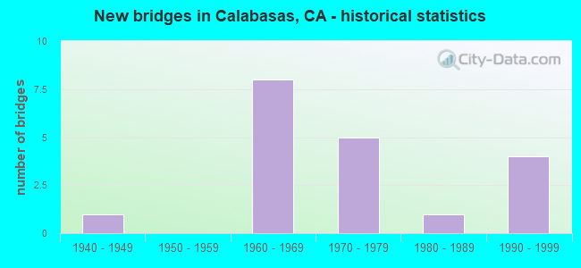
- New bridges - historical statistics
- 11940-1949
- 81960-1969
- 51970-1979
- 11980-1989
- 41990-1999

- Reconstructed bridges - Historical Statistics
- 11960-1969
- 11970-1979
- 11980-1989
- 11990-1999


- Bridge Condition - Deck
- 75.0%Good
- 25.0%Fair

- Bridge Condition - Superstructure
- 60.0%Good
- 20.0%Satisfactory
- 20.0%Fair

- Bridge Condition - Channel
- 7.7%Excellent
- 23.1%Very good
- 46.2%Good
- 23.1%Satisfactory

- Bridge Condition - Culverts
- 18.2%Very good
- 72.7%Good
- 9.1%Satisfactory
Find on map >> Show street view
Structure Number: 53 0003, Location: 07-LA-101-31.37 (Lat: 34.145158, Lng: -118.701811), Route carried "on" structure: US 101, Year Built: 1973, Year Reconstructed: 1988, Status: Open, Structure Length: 1.71m (5.61ft), Average Daily Traffic: 167,000 (year 2018), Truck Traffic: 10%, Average Future Daily Traffic: 200,129 (year 2038), Design Load: HS 20, Features Intersected: LAS VIRGENES CREEK
Minimum Vertical Clearance: 30+ m (98+ ft), Kilometerpoint: 31.370, Lanes on structure: 10, Base Highway Network: Yes (Inventory Route: 1, Subroute: 1), Owner: State Highway Agency, Approaching Roadway Width: 51.2m (168.0ft), Skew: 29 degrees, Material/Design: Concrete, Design/Construction: Culvert, Number Of Spans In Main Unit: 3, Length of Maximum Span: 4.9m (16.1ft), Curb-To-Curb Width: 51.2m (168.0ft), Out-to-Out Width: 51.2m (168.0ft)
Condition: Channel: Very good, Culverts: Good, Operating Rating: 54.1 metric tons, Method Used To Determine Operating Rating: Load Factor (LF), Inventory Rating: 32.4 metric tons, Method Used To Determine Inventory Rating: Load Factor (LF), Structural Evaluation: Better than present minimum criteria, Deck Geometry: Superior to present desirable criteria, Waterway Adequacy: Equal to present desirable criteria, Approach Roadway Alignment: Equal to present desirable criteria, Designated Inspection Frequency: Every 48 months, Inspection Date: May 2020
Find on map >> Show street view
Structure Number: 53 1442, Location: 07-LA-101-31.05 (Lat: 34.148244, Lng: -118.697675), Route carried "on" structure: County highway L839, Year Built: 1962, Year Reconstructed: 1973, Status: Open, Structure Length: 8.44m (27.69ft), Average Daily Traffic: 18,700 (year 2018), Truck Traffic: 1%, Average Future Daily Traffic: 27,429 (year 2040), Design Load: HS 20, Features Intersected: ROUTE 101, Facility Carried by Structure: LAS VIRGENES RD
Minimum Vertical Clearance: 30+ m (98+ ft), Kilometerpoint: 0.000, Lanes on structure: 4, Lanes under structure: 8, Base Highway Network: Yes, Owner: State Highway Agency, Approaching Roadway Width: 21.3m (69.9ft), Skew: 24 degrees, Material/Design: Steel, Design/Construction: Stringer/Multi-beam, Number Of Spans In Main Unit: 4, Length of Maximum Span: 29.3m (96.1ft), Curb or Sidewalk Widths: Left: 2.3m (7.5ft), Right: 2.3m (7.5ft), Curb-To-Curb Width: 21.3m (69.9ft), Out-to-Out Width: 30.8m (101.0ft)
Condition: Deck: Good, Superstructure: Good, Substructure: Good, Operating Rating: 44.4 metric tons, Method Used To Determine Operating Rating: Load Factor (LF), Inventory Rating: 26.6 metric tons, Method Used To Determine Inventory Rating: Load Factor (LF), Structural Evaluation: Equal to present minimum criteria, Deck Geometry: Superior to present desirable criteria, Underclear: High priority of corrective action, Approach Roadway Alignment: Equal to present desirable criteria, Designated Inspection Frequency: Every 24 months, Other Special Inspection Frequency: Every 48 months, Inspection Date: May 2020, Other Special Inspection Date: November 2019, Deck Structure Type: Concrete Cast-file-Place
Find on map >> Show street view
Structure Number: 53 1681, Location: 07-LA-101-29.06 (Lat: 34.149506, Lng: -118.664722), Route carried "on" structure: County highway L841, Year Built: 1965, Status: Open, Structure Length: 6.22m (20.41ft), Average Daily Traffic: 5,000 (year 2018), Truck Traffic: 2%, Average Future Daily Traffic: 7,600 (year 2040), Design Load: HS 20, Features Intersected: ROUTE 101, Facility Carried by Structure: MUREAU RD
Minimum Vertical Clearance: 30+ m (98+ ft), Kilometerpoint: 0.000, Lanes on structure: 2, Lanes under structure: 8, Owner: State Highway Agency, Approaching Roadway Width: 12.2m (40.0ft), Material/Design: Prestressed concrete continuous, Design/Construction: Stringer/Multi-beam, Number Of Spans In Main Unit: 2, Number Of Approach Spans: 2, Length of Maximum Span: 21.6m (70.9ft), Curb or Sidewalk Widths: Left: 0.0m, Right: 1.5m (4.9ft), Curb-To-Curb Width: 9.8m (32.2ft), Out-to-Out Width: 12.1m (39.7ft)
Condition: Deck: Good, Superstructure: Good, Substructure: Good, Operating Rating: 34.7 metric tons, Method Used To Determine Operating Rating: Load and Resistance Factor Rating (LRFR) rating reported by rating factor(RF) method using HL-93 loadings, Inventory Rating: 24.0 metric tons, Method Used To Determine Inventory Rating: Load and Resistance Factor Rating (LRFR) rating reported by rating factor(RF) method using HL-93 loadings, Structural Evaluation: Equal to present minimum criteria, Deck Geometry: Meets minimum limits, Underclear: Meets minimum limits, Approach Roadway Alignment: Equal to present minimum criteria, Designated Inspection Frequency: Every 24 months, Inspection Date: May 2020, Deck Structure Type: Concrete Cast-file-Place, Wearing Surface/Protective System: Wearing Surface: Monolithic Concrete
Find on map >> Show street view
Structure Number: 53C0397, Location: 0.1MI W/O LAS VIRGENES (Lat: 34.143606, Lng: -118.700808), Route carried "on" structure: City street N045, Year Built: 1972, Year Reconstructed: 2002, Status: Open, Structure Length: 5.80m (19.03ft), Average Daily Traffic: 8,709 (year 2015), Truck Traffic: 2%, Average Future Daily Traffic: 10,500 (year 2040), Design Load: HS 20+Mod, Features Intersected: LAS VIRGENES CRK, Facility Carried by Structure: AGOURA RD
Minimum Vertical Clearance: 30.47m (99.97ft), Kilometerpoint: 0.000, Lanes on structure: 4, Owner: City or Municipal Highway Agency, Approaching Roadway Width: 23.6m (77.4ft), Skew: 9 degrees, Material/Design: Concrete continuous, Design/Construction: Box Beam or Girders - Multiple, Number Of Spans In Main Unit: 3, Length of Maximum Span: 21.2m (69.6ft), Curb or Sidewalk Widths: Left: 2.5m (8.2ft), Right: 1.5m (4.9ft), Curb-To-Curb Width: 23.4m (76.8ft), Out-to-Out Width: 28.0m (91.9ft)
Condition: Deck: Fair, Superstructure: Fair, Substructure: Good, Channel: Good, Operating Rating: 57.0 metric tons, Method Used To Determine Operating Rating: Load Factor (LF), Inventory Rating: 34.3 metric tons, Method Used To Determine Inventory Rating: Load Factor (LF), Structural Evaluation: Somewhat better than minimum adequacy, Deck Geometry: Superior to present desirable criteria, Waterway Adequacy: Better than present minimum criteria, Approach Roadway Alignment: Equal to present minimum criteria, Designated Inspection Frequency: Every 24 months, Inspection Date: October 2020, Deck Structure Type: Concrete Cast-file-Place
Find on map >> Show street view
Structure Number: 53C0607, Location: 3.5MI S/O US-101 FWY (Lat: 34.103425, Lng: -118.713028), Route carried "on" structure: County highway L722, Year Built: 1941, Status: Open, Structure Length: 3.78m (12.40ft), Average Daily Traffic: 1,122 (year 2012), Truck Traffic: 1%, Average Future Daily Traffic: 1,234 (year 2040), Features Intersected: LAS VIRGENES CR, Facility Carried by Structure: MULHOLLAND HWY
Minimum Vertical Clearance: 30.47m (99.97ft), Kilometerpoint: 0.000, Lanes on structure: 2, Owner: County Highway Agency, Approaching Roadway Width: 7.9m (25.9ft), Material/Design: Concrete continuous, Design/Construction: Slab, Number Of Spans In Main Unit: 3, Length of Maximum Span: 21.3m (69.9ft), Curb or Sidewalk Widths: Left: 1.5m (4.9ft), Right: 1.5m (4.9ft), Curb-To-Curb Width: 7.2m (23.6ft), Out-to-Out Width: 11.3m (37.1ft)
Condition: Deck: Good, Superstructure: Good, Substructure: Good, Channel: Good, Operating Rating: 49.2 metric tons, Method Used To Determine Operating Rating: Load Factor (LF), Inventory Rating: 29.5 metric tons, Method Used To Determine Inventory Rating: Load Factor (LF), Structural Evaluation: Better than present minimum criteria, Deck Geometry: High priority of corrective action, Waterway Adequacy: Equal to present desirable criteria, Approach Roadway Alignment: Equal to present desirable criteria, Designated Inspection Frequency: Every 24 months, Inspection Date: November 2020, Deck Structure Type: Concrete Cast-file-Place, Wearing Surface/Protective System: Wearing Surface: Monolithic Concrete, Membrane: Epoxy, Deck Protection: Epoxy Coated Reinforcing
Find on map >> Show street view
Structure Number: 53C08, Location: 450FT N/O US-101 FWY (Lat: 34.150017, Lng: -118.697736), Route carried "on" structure: City street L839, Year Built: 1965, Status: Open, Structure Length: 1.58m (5.18ft), Average Daily Traffic: 17,655 (year 2012), Truck Traffic: 2%, Average Future Daily Traffic: 21,186 (year 2040), Design Load: HS 20, Features Intersected: LAS VIRGENES CR, Facility Carried by Structure: LAS VIRGENES RD
Minimum Vertical Clearance: 30.47m (99.97ft), Kilometerpoint: 0.000, Lanes on structure: 4, Owner: City or Municipal Highway Agency, Approaching Roadway Width: 21.1m (69.2ft), Skew: 20 degrees, Material/Design: Concrete, Design/Construction: Culvert, Number Of Spans In Main Unit: 2, Length of Maximum Span: 5.5m (18.0ft), Curb or Sidewalk Widths: Left: 0.2m (0.7ft), Right: 2.3m (7.5ft), Curb-To-Curb Width: 25.6m (84.0ft), Out-to-Out Width: 30.5m (100.1ft)
Condition: Channel: Good, Culverts: Good, Operating Rating: 54.1 metric tons, Method Used To Determine Operating Rating: Field evaluation and documented engineering judgment, Inventory Rating: 32.4 metric tons, Method Used To Determine Inventory Rating: Field evaluation and documented engineering judgment, Structural Evaluation: Better than present minimum criteria, Deck Geometry: Superior to present desirable criteria, Waterway Adequacy: Better than present minimum criteria, Approach Roadway Alignment: Equal to present desirable criteria, Designated Inspection Frequency: Every 48 months, Inspection Date: August 2020
Find on map >> Show street view
Structure Number: 53C1472, Location: 0.1MI E/O PK GRANADA (Lat: 34.155975, Lng: -118.639422), Route carried "on" structure: City street , Year Built: 1968, Status: Open, Structure Length: 0.79m (2.59ft), Average Daily Traffic: 3,978 (year 2012), Truck Traffic: 1%, Average Future Daily Traffic: 4,376 (year 2040), Features Intersected: MC COY CYN CRK, Facility Carried by Structure: PARK SORRENTO
Minimum Vertical Clearance: 30.47m (99.97ft), Kilometerpoint: 0.000, Lanes on structure: 2, Owner: City or Municipal Highway Agency, Approaching Roadway Width: 12.2m (40.0ft), Skew: 3 degrees, Material/Design: Concrete, Design/Construction: Culvert, Number Of Spans In Main Unit: 2, Length of Maximum Span: 3.0m (9.8ft), Curb or Sidewalk Widths: Left: 1.7m (5.6ft), Right: 1.7m (5.6ft), Curb-To-Curb Width: 13.5m (44.3ft), Out-to-Out Width: 24.8m (81.4ft)
Condition: Channel: Good, Culverts: Very good, Operating Rating: 40.5 metric tons, Method Used To Determine Operating Rating: Field evaluation and documented engineering judgment, Inventory Rating: 24.3 metric tons, Method Used To Determine Inventory Rating: Field evaluation and documented engineering judgment, Structural Evaluation: Equal to present minimum criteria, Deck Geometry: Superior to present desirable criteria, Waterway Adequacy: Better than present minimum criteria, Approach Roadway Alignment: Better than present minimum criteria, Designated Inspection Frequency: Every 24 months, Inspection Date: August 2020
Find on map >> Show street view
Structure Number: 53C1474, Location: 300FT S/O PK GRANADA (Lat: 34.149675, Lng: -118.643303), Route carried "on" structure: City street , Year Built: 1967, Status: Open, Structure Length: 0.63m (2.07ft), Average Daily Traffic: 6,180 (year 2012), Truck Traffic: 1%, Average Future Daily Traffic: 7,107 (year 2040), Features Intersected: MCCOY CYN CRK, Facility Carried by Structure: PARK CAPRI
Minimum Vertical Clearance: 30.47m (99.97ft), Kilometerpoint: 0.000, Lanes on structure: 2, Owner: City or Municipal Highway Agency, Approaching Roadway Width: 16.2m (53.1ft), Skew: 20 degrees, Material/Design: Concrete, Design/Construction: Culvert, Number Of Spans In Main Unit: 2, Length of Maximum Span: 3.0m (9.8ft), Curb or Sidewalk Widths: Left: 1.2m (3.9ft), Right: 1.2m (3.9ft), Curb-To-Curb Width: 16.1m (52.8ft), Out-to-Out Width: 26.8m (87.9ft)
Condition: Channel: Satisfactory, Culverts: Good, Operating Rating: 40.5 metric tons, Method Used To Determine Operating Rating: Field evaluation and documented engineering judgment, Inventory Rating: 24.3 metric tons, Method Used To Determine Inventory Rating: Field evaluation and documented engineering judgment, Structural Evaluation: Equal to present minimum criteria, Deck Geometry: Superior to present desirable criteria, Waterway Adequacy: Better than present minimum criteria, Approach Roadway Alignment: Equal to present minimum criteria, Designated Inspection Frequency: Every 24 months, Inspection Date: August 2020
Find on map >> Show street view
Structure Number: 53C1536, Location: 200FT N/O PKWY CALABASAS (Lat: 34.142103, Lng: -118.654436), Route carried "on" structure: City street , Year Built: 1970, Status: Open, Structure Length: 0.79m (2.59ft), Average Daily Traffic: 2,754 (year 2012), Truck Traffic: 1%, Average Future Daily Traffic: 3,029 (year 2040), Features Intersected: PRIVATE DRN #808, Facility Carried by Structure: PARK ENTRADA
Minimum Vertical Clearance: 30.47m (99.97ft), Kilometerpoint: 0.000, Lanes on structure: 2, Owner: City or Municipal Highway Agency, Approaching Roadway Width: 12.1m (39.7ft), Skew: 2 degrees, Material/Design: Concrete, Design/Construction: Culvert, Number Of Spans In Main Unit: 2, Length of Maximum Span: 3.4m (11.2ft), Curb or Sidewalk Widths: Left: 1.6m (5.2ft), Right: 1.6m (5.2ft), Curb-To-Curb Width: 12.1m (39.7ft), Out-to-Out Width: 24.7m (81.0ft)
Condition: Channel: Very good, Culverts: Satisfactory, Operating Rating: 40.5 metric tons, Method Used To Determine Operating Rating: Field evaluation and documented engineering judgment, Inventory Rating: 24.3 metric tons, Method Used To Determine Inventory Rating: Field evaluation and documented engineering judgment, Structural Evaluation: Equal to present minimum criteria, Deck Geometry: Somewhat better than minimum adequacy, Waterway Adequacy: Equal to present minimum criteria, Approach Roadway Alignment: Better than present minimum criteria, Designated Inspection Frequency: Every 24 months, Inspection Date: August 2020
Find on map >> Show street view
Structure Number: 53C1607, Location: 200FT E/O LOS VIRGENES RD (Lat: 34.153489, Lng: -118.696833), Route carried "on" structure: City street NR91, Year Built: 1974, Status: Open, Structure Length: 0.86m (2.82ft), Average Daily Traffic: 4,794 (year 2012), Truck Traffic: 1%, Average Future Daily Traffic: 5,273 (year 2040), Features Intersected: LAS VIRGENES CRK, Facility Carried by Structure: PARKMOR RD
Minimum Vertical Clearance: 30.47m (99.97ft), Kilometerpoint: 0.000, Lanes on structure: 2, Owner: City or Municipal Highway Agency, Approaching Roadway Width: 10.9m (35.8ft), Skew: 3 degrees, Material/Design: Concrete, Design/Construction: Culvert, Number Of Spans In Main Unit: 2, Length of Maximum Span: 4.2m (13.8ft), Curb or Sidewalk Widths: Left: 3.5m (11.5ft), Right: 3.5m (11.5ft), Curb-To-Curb Width: 10.9m (35.8ft), Out-to-Out Width: 26.3m (86.3ft)
Condition: Channel: Very good, Culverts: Good, Operating Rating: 54.1 metric tons, Method Used To Determine Operating Rating: Field evaluation and documented engineering judgment, Inventory Rating: 32.4 metric tons, Method Used To Determine Inventory Rating: Field evaluation and documented engineering judgment, Structural Evaluation: Better than present minimum criteria, Deck Geometry: Somewhat better than minimum adequacy, Waterway Adequacy: Better than present minimum criteria, Approach Roadway Alignment: Better than present minimum criteria, Designated Inspection Frequency: Every 48 months, Inspection Date: August 2020
Find on map >> Show street view
Structure Number: 53C1657, Location: 200FT E/O LAS VIRGENES RD (Lat: 34.160333, Lng: -118.701186), Route carried "on" structure: City street N029, Year Built: 1974, Year Reconstructed: 1979, Status: Open, Structure Length: 1.01m (3.31ft), Average Daily Traffic: 4,998 (year 2012), Truck Traffic: 1%, Average Future Daily Traffic: 5,498 (year 2040), Design Load: HS 20, Features Intersected: LAS VIRGENES CRK, Facility Carried by Structure: THOUSAND OAKS BLVD
Minimum Vertical Clearance: 30.47m (99.97ft), Kilometerpoint: 0.000, Lanes on structure: 4, Owner: City or Municipal Highway Agency, Approaching Roadway Width: 20.5m (67.3ft), Skew: 22 degrees, Material/Design: Concrete, Design/Construction: Culvert, Number Of Spans In Main Unit: 2, Length of Maximum Span: 5.0m (16.4ft), Curb or Sidewalk Widths: Left: 2.3m (7.5ft), Right: 2.3m (7.5ft), Curb-To-Curb Width: 20.5m (67.3ft), Out-to-Out Width: 45.8m (150.3ft)
Condition: Channel: Excellent, Culverts: Good, Operating Rating: 54.1 metric tons, Method Used To Determine Operating Rating: Field evaluation and documented engineering judgment, Inventory Rating: 32.4 metric tons, Method Used To Determine Inventory Rating: Field evaluation and documented engineering judgment, Structural Evaluation: Better than present minimum criteria, Deck Geometry: Superior to present desirable criteria, Waterway Adequacy: Superior to present desirable criteria, Approach Roadway Alignment: Equal to present minimum criteria, Designated Inspection Frequency: Every 48 months, Inspection Date: August 2020
Find on map >> Show street view
Structure Number: 53C1847, Location: 0.7MI S/O MULHOLLAND HWY (Lat: 34.091839, Lng: -118.679864), Route carried "on" structure: County highway WPE3, Year Built: 1981, Status: Open, Structure Length: 0.79m (2.59ft), Average Daily Traffic: 1,122 (year 2012), Truck Traffic: 2%, Average Future Daily Traffic: 1,234 (year 2040), Features Intersected: COLD CYN CRK, Facility Carried by Structure: COLD CYN RD
Minimum Vertical Clearance: 30.47m (99.97ft), Kilometerpoint: 0.000, Lanes on structure: 2, Owner: County Highway Agency, Approaching Roadway Width: 7.3m (24.0ft), Material/Design: Steel, Design/Construction: Culvert, Number Of Spans In Main Unit: 1, Length of Maximum Span: 7.9m (25.9ft)
Condition: Channel: Satisfactory, Culverts: Good, Operating Rating: 99.8 metric tons, Method Used To Determine Operating Rating: Load Factor (LF), Inventory Rating: 99.8 metric tons, Method Used To Determine Inventory Rating: Load Factor (LF), Structural Evaluation: Better than present minimum criteria, Waterway Adequacy: Better than present minimum criteria, Approach Roadway Alignment: Equal to present minimum criteria, Designated Inspection Frequency: Every 48 months, Inspection Date: November 2020
Find on map >> Show street view
Structure Number: 53C1956, Location: 300FT W/O LAS VIRGNES RD (Lat: 34.126183, Lng: -118.706617), Route carried "on" structure: City street W484, Year Built: 1990, Status: Open, Structure Length: 2.07m (6.79ft), Average Daily Traffic: 5,871 (year 2012), Truck Traffic: 2%, Average Future Daily Traffic: 6,752 (year 2040), Features Intersected: LAS VIRGENES CRK, Facility Carried by Structure: LOST HILLS RD
Minimum Vertical Clearance: 30.47m (99.97ft), Kilometerpoint: 0.000, Lanes on structure: 5, Owner: City or Municipal Highway Agency, Approaching Roadway Width: 21.0m (68.9ft), Skew: 22 degrees, Material/Design: Concrete, Design/Construction: Culvert, Number Of Spans In Main Unit: 4, Length of Maximum Span: 4.3m (14.1ft), Curb or Sidewalk Widths: Left: 2.3m (7.5ft), Right: 2.3m (7.5ft), Curb-To-Curb Width: 22.1m (72.5ft), Out-to-Out Width: 78.1m (256.2ft)
Condition: Channel: Good, Culverts: Very good, Operating Rating: 54.1 metric tons, Method Used To Determine Operating Rating: Field evaluation and documented engineering judgment, Inventory Rating: 32.4 metric tons, Method Used To Determine Inventory Rating: Field evaluation and documented engineering judgment, Structural Evaluation: Equal to present desirable criteria, Deck Geometry: Somewhat better than minimum adequacy, Waterway Adequacy: Equal to present desirable criteria, Approach Roadway Alignment: Equal to present minimum criteria, Designated Inspection Frequency: Every 48 months, Inspection Date: August 2020
Find on map >> Show street view
Structure Number: 53C1957, Location: 0.1MI E/O LOST HILLS RD (Lat: 34.129158, Lng: -118.707869), Route carried "on" structure: City street , Year Built: 1990, Status: Open, Structure Length: 1.80m (5.91ft), Average Daily Traffic: 5,871 (year 2012), Truck Traffic: 2%, Average Future Daily Traffic: 6,752 (year 2040), Features Intersected: LAS VIRGENES CRK, Facility Carried by Structure: MEADOW CRK LN
Minimum Vertical Clearance: 30.47m (99.97ft), Kilometerpoint: 0.000, Lanes on structure: 2, Owner: City or Municipal Highway Agency, Approaching Roadway Width: 12.2m (40.0ft), Material/Design: Concrete, Design/Construction: Culvert, Number Of Spans In Main Unit: 4, Length of Maximum Span: 4.2m (13.8ft), Curb or Sidewalk Widths: Left: 3.6m (11.8ft), Right: 3.6m (11.8ft), Curb-To-Curb Width: 12.1m (39.7ft), Out-to-Out Width: 26.8m (87.9ft)
Condition: Channel: Good, Culverts: Good, Operating Rating: 54.1 metric tons, Method Used To Determine Operating Rating: Field evaluation and documented engineering judgment, Inventory Rating: 32.4 metric tons, Method Used To Determine Inventory Rating: Field evaluation and documented engineering judgment, Structural Evaluation: Better than present minimum criteria, Deck Geometry: Somewhat better than minimum adequacy, Waterway Adequacy: Equal to present desirable criteria, Approach Roadway Alignment: Equal to present minimum criteria, Designated Inspection Frequency: Every 48 months, Inspection Date: September 2020
Find on map >> Show street view
Structure Number: 53C1958, Location: 1.6MI S/O US-101 FWY (Lat: 34.139792, Lng: -118.662431), Route carried "on" structure: City street , Year Built: 1991, Status: Open, Structure Length: 0.67m (2.20ft), Average Daily Traffic: 14,057 (year 2015), Truck Traffic: 2%, Average Future Daily Traffic: 13,503 (year 2040), Features Intersected: GOLF COURSE ACCESS RD, Facility Carried by Structure: PARKWAY CALABASAS
Minimum Vertical Clearance: 30.47m (99.97ft), Kilometerpoint: 0.000, Lanes on structure: 4, Owner: City or Municipal Highway Agency, Approaching Roadway Width: 14.7m (48.2ft), Skew: 20 degrees, Material/Design: Steel, Design/Construction: Arch - Deck, Number Of Spans In Main Unit: 1, Length of Maximum Span: 6.7m (22.0ft), Curb or Sidewalk Widths: Left: 0.2m (0.7ft), Right: 2.1m (6.9ft), Curb-To-Curb Width: 18.0m (59.1ft), Out-to-Out Width: 21.7m (71.2ft)
Condition: Superstructure: Satisfactory, Substructure: Good, Operating Rating: 54.1 metric tons, Method Used To Determine Operating Rating: Field evaluation and documented engineering judgment, Inventory Rating: 32.4 metric tons, Method Used To Determine Inventory Rating: Field evaluation and documented engineering judgment, Structural Evaluation: Equal to present minimum criteria, Deck Geometry: Somewhat better than minimum adequacy, Approach Roadway Alignment: Equal to present desirable criteria, Designated Inspection Frequency: Every 48 months, Inspection Date: September 2020
Find on map >> Show street view
Structure Number: 53C1965, Location: 0.3MI S/O MULHOLLAND HWY (Lat: 34.100478, Lng: -118.710953), Route carried "on" structure: County highway W483, Year Built: 1991, Status: Open, Structure Length: 0.91m (2.99ft), Average Daily Traffic: 24,804 (year 2012), Truck Traffic: 2%, Average Future Daily Traffic: 29,765 (year 2041), Design Load: HS 20, Features Intersected: STOKES CYN CRK, Facility Carried by Structure: LAS VIRGENES RD
Minimum Vertical Clearance: 30+ m (98+ ft), Kilometerpoint: 0.000, Lanes on structure: 4, Owner: County Highway Agency, Approaching Roadway Width: 14.9m (48.9ft), Skew: 2 degrees, Material/Design: Concrete, Design/Construction: Culvert, Number Of Spans In Main Unit: 1, Length of Maximum Span: 9.1m (29.9ft), Curb-To-Curb Width: 15.0m (49.2ft), Out-to-Out Width: 26.9m (88.3ft)
Condition: Channel: Satisfactory, Culverts: Good, Operating Rating: 54.1 metric tons, Method Used To Determine Operating Rating: Field evaluation and documented engineering judgment, Inventory Rating: 32.4 metric tons, Method Used To Determine Inventory Rating: Field evaluation and documented engineering judgment, Structural Evaluation: Better than present minimum criteria, Deck Geometry: High priority of replacement, Waterway Adequacy: Better than present minimum criteria, Approach Roadway Alignment: Equal to present minimum criteria, Designated Inspection Frequency: Every 48 months, Inspection Date: April 2021
Find on map >> Show street view
Structure Number: 53 1442, Location: 07-LA-101-31.05 (Lat: 34.148244, Lng: -118.697675), Route carried "under" structure: US 101, Year Built: 1962, Structure Length: 0. m, Average Daily Traffic: 196,000 (year 2018), Truck Traffic: 10%, Features Intersected: ROUTE 101, Facility Carried by Structure: LAS VIRGENES RD
Minimum Vertical Clearance: 4.60m (15.09ft), Kilometerpoint: 31.050, Lanes on structure: 4, Lanes under structure: 8, Material/Design: Steel, Design/Construction: Stringer/Multi-beam, Length of Maximum Span: 29.3m (96.1ft)
Find on map >> Show street view
Structure Number: 53 1681, Location: 07-LA-101-29.06 (Lat: 34.149506, Lng: -118.664722), Route carried "under" structure: US 101, Year Built: 1965, Structure Length: 0. m, Average Daily Traffic: 196,000 (year 2018), Truck Traffic: 10%, Features Intersected: ROUTE 101, Facility Carried by Structure: MUREAU RD
Minimum Vertical Clearance: 4.83m (15.85ft), Kilometerpoint: 29.060, Lanes on structure: 2, Lanes under structure: 8, Material/Design: Prestressed concrete continuous, Design/Construction: Stringer/Multi-beam, Length of Maximum Span: 21.6m (70.9ft)
Find on map >> Show street view
Structure Number: 53 173, Location: 07-LA-101-31.91 (Lat: 34.140644, Lng: -118.709417), Route carried "under" structure: US 101, Year Built: 1965, Structure Length: 0. m, Average Daily Traffic: 177,000 (year 2018), Truck Traffic: 10%, Features Intersected: ROUTE 101, Facility Carried by Structure: LOST HILLS RD
Minimum Vertical Clearance: 4.72m (15.49ft), Kilometerpoint: 31.910, Lanes on structure: 2, Lanes under structure: 8, Material/Design: Prestressed concrete, Design/Construction: Stringer/Multi-beam, Length of Maximum Span: 27.6m (90.6ft)