Bridge Statistics for El Paso de Robles (Paso Robles), California (CA)
Condition, Traffic, Stress, Structural Evaluation, Project Costs
- National Bridge Inventory (NBI) Statistics
- 37Number of bridges
- 876ft / 267mTotal length
- $15,691,000Total costs
- 507,728Total average daily traffic
- 38,845Total average daily truck traffic
- National Bridge Inventory (NBI) Registered Bridges for El Paso de Robles (Paso Robles)
- No street view available for this location
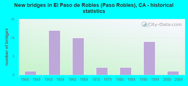
- New bridges - historical statistics
- 11940-1949
- 121950-1959
- 101960-1969
- 21970-1979
- 21980-1989
- 91990-1999
- 12000-2009

- Reconstructed bridges - Historical Statistics
- 11960-1969
- 01970-1979
- 11980-1989
- 21990-1999
- 22000-2009


- Bridge Condition - Deck
- 42.3%Good
- 26.9%Satisfactory
- 15.4%Fair
- 15.4%Poor

- Bridge Condition - Superstructure
- 88.5%Good
- 7.7%Satisfactory
- 3.8%Serious

- Bridge Condition - Substructure
- 73.1%Good
- 15.4%Satisfactory
- 7.7%Fair
- 3.8%Poor

- Bridge Condition - Channel
- 66.7%Very good
- 26.7%Good
- 6.7%Satisfactory
Find on map >> Show street view
Structure Number: 49 0034R, Location: 05-SLO-046-31.97 (Lat: 35.644403, Lng: -120.646450), Route carried "on" structure: State highway 46, Year Built: 1992, Status: Open, Structure Length: 10.19m (33.43ft), Average Daily Traffic: 8,050 (year 2009), Truck Traffic: 11%, Average Future Daily Traffic: 16,983 (year 2037), Design Load: HS 20+Mod, Features Intersected: HUER HUERO CREEK
Minimum Vertical Clearance: 30+ m (98+ ft), Kilometerpoint: 31.970, Lanes on structure: 2, Base Highway Network: Yes (, Subroute: 1), Owner: State Highway Agency, Approaching Roadway Width: 15.5m (50.9ft), Skew: 1 degrees, Material/Design: Prestressed concrete continuous, Design/Construction: Box Beam or Girders - Multiple, Number Of Spans In Main Unit: 3, Length of Maximum Span: 40.2m (131.9ft), Curb-To-Curb Width: 15.5m (50.9ft), Out-to-Out Width: 16.6m (54.5ft)
Condition: Deck: Satisfactory, Superstructure: Good, Substructure: Good, Channel: Very good, Operating Rating: 54.1 metric tons, Method Used To Determine Operating Rating: Assigned rating based on Load Factor Design (LFD) reported in metric tons, Inventory Rating: 32.4 metric tons, Method Used To Determine Inventory Rating: Assigned rating based on Load Factor Design (LFD) reported in metric tons, Structural Evaluation: Better than present minimum criteria, Deck Geometry: Superior to present desirable criteria, Waterway Adequacy: Superior to present desirable criteria, Approach Roadway Alignment: Equal to present desirable criteria, Designated Inspection Frequency: Every 24 months, Inspection Date: September 2020, Deck Structure Type: Concrete Cast-file-Place
Find on map >> Show street view
Structure Number: 49 0035, Location: 05-SLO-046-29.80-PSRS (Lat: 35.642650, Lng: -120.684519), Route carried "on" structure: State highway 46, Year Built: 1992, Status: Open, Structure Length: 23.71m (77.79ft), Average Daily Traffic: 27,100 (year 2008), Truck Traffic: 10%, Average Future Daily Traffic: 65,397 (year 2037), Design Load: HS 20+Mod, Features Intersected: SALINAS RIVER, RIVER RD
Minimum Vertical Clearance: 30+ m (98+ ft), Kilometerpoint: 29.800, Lanes on structure: 4, Lanes under structure: 2, Base Highway Network: Yes (, Subroute: 1), Owner: State Highway Agency, Approaching Roadway Width: 28.0m (91.9ft), Skew: 9 degrees, Material/Design: Prestressed concrete continuous, Design/Construction: Box Beam or Girders - Multiple, Number Of Spans In Main Unit: 5, Length of Maximum Span: 52.4m (171.9ft), Curb-To-Curb Width: 28.0m (91.9ft), Out-to-Out Width: 29.1m (95.5ft)
Condition: Deck: Satisfactory, Superstructure: Satisfactory, Substructure: Good, Channel: Good, Operating Rating: 54.1 metric tons, Method Used To Determine Operating Rating: Assigned rating based on Load Factor Design (LFD) reported in metric tons, Inventory Rating: 32.4 metric tons, Method Used To Determine Inventory Rating: Assigned rating based on Load Factor Design (LFD) reported in metric tons, Structural Evaluation: Equal to present minimum criteria, Deck Geometry: Superior to present desirable criteria, Underclear: Meets minimum limits, Waterway Adequacy: Superior to present desirable criteria, Approach Roadway Alignment: Equal to present desirable criteria, Designated Inspection Frequency: Every 24 months, Inspection Date: September 2020, Deck Structure Type: Concrete Cast-file-Place
Find on map >> Show street view
Structure Number: 49 0138, Location: 05-SLO-046-34.14 (Lat: 35.656633, Lng: -120.611847), Route carried "on" structure: State highway 46, Year Built: 1954, Year Reconstructed: 2008, Status: Open, Structure Length: 0.79m (2.59ft), Average Daily Traffic: 16,100 (year 2009), Average Future Daily Traffic: 33,521 (year 2037), Features Intersected: DRY CREEK
Minimum Vertical Clearance: 30+ m (98+ ft), Kilometerpoint: 34.140, Lanes on structure: 2, Base Highway Network: Yes (, Subroute: 1), Owner: State Highway Agency, Approaching Roadway Width: 38.3m (125.7ft), Material/Design: Concrete continuous, Design/Construction: Culvert, Number Of Spans In Main Unit: 2, Length of Maximum Span: 3.7m (12.1ft), Curb or Sidewalk Widths: Left: 0.9m (3.0ft), Right: 0.9m (3.0ft), Curb-To-Curb Width: 34.7m (113.8ft), Out-to-Out Width: 38.4m (126.0ft)
Condition: Channel: Very good, Culverts: Satisfactory, Operating Rating: 54.1 metric tons, Method Used To Determine Operating Rating: Field evaluation and documented engineering judgment, Inventory Rating: 32.4 metric tons, Method Used To Determine Inventory Rating: Field evaluation and documented engineering judgment, Structural Evaluation: Equal to present minimum criteria, Deck Geometry: Superior to present desirable criteria, Waterway Adequacy: Superior to present desirable criteria, Approach Roadway Alignment: Equal to present desirable criteria, Designated Inspection Frequency: Every 24 months, Inspection Date: September 2020
Find on map >> Show street view
Structure Number: 49 0141, Location: 05-SLO-101-48.33 (Lat: 35.513089, Lng: -120.699656), Route carried "on" structure: County highway Y054, Year Built: 1967, Status: Open, Structure Length: 5.06m (16.60ft), Average Daily Traffic: 4,000 (year 2005), Truck Traffic: 5%, Average Future Daily Traffic: 6,626 (year 2037), Design Load: HS 20, Features Intersected: US HIGHWAY 101, Facility Carried by Structure: DEL RIO ROAD
Minimum Vertical Clearance: 30+ m (98+ ft), Kilometerpoint: 0.000, Lanes on structure: 2, Lanes under structure: 4, Base Highway Network: Yes, Owner: State Highway Agency, Approaching Roadway Width: 11.0m (36.1ft), Material/Design: Concrete continuous, Design/Construction: Box Beam or Girders - Multiple, Number Of Spans In Main Unit: 2, Length of Maximum Span: 25.0m (82.0ft), Curb or Sidewalk Widths: Left: 0.0m, Right: 1.5m (4.9ft), Curb-To-Curb Width: 9.2m (30.2ft), Out-to-Out Width: 11.3m (37.1ft)
Condition: Deck: Satisfactory, Superstructure: Good, Substructure: Good, Operating Rating: 42.4 metric tons, Method Used To Determine Operating Rating: Load and Resistance Factor Rating (LRFR) rating reported by rating factor(RF) method using HL-93 loadings, Inventory Rating: 32.7 metric tons, Method Used To Determine Inventory Rating: Load and Resistance Factor Rating (LRFR) rating reported by rating factor(RF) method using HL-93 loadings, Structural Evaluation: Better than present minimum criteria, Deck Geometry: Meets minimum limits, Underclear: High priority of corrective action, Approach Roadway Alignment: Equal to present desirable criteria, Designated Inspection Frequency: Every 48 months, Inspection Date: May 2019, Deck Structure Type: Concrete Cast-file-Place
Find on map >> Show street view
Structure Number: 49 0145, Location: 05-SLO-101-56.88-PSRS (Lat: 35.627894, Lng: -120.686794), Route carried "on" structure: City street Z654, Year Built: 1958, Status: Open, Structure Length: 3.40m (11.15ft), Average Daily Traffic: 16,000 (year 2005), Truck Traffic: 5%, Average Future Daily Traffic: 29,562 (year 2043), Design Load: HS 20, Features Intersected: US HIGHWAY 101, Facility Carried by Structure: 13TH ST
Minimum Vertical Clearance: 30+ m (98+ ft), Kilometerpoint: 0.000, Lanes on structure: 5, Lanes under structure: 4, Base Highway Network: Yes, Owner: State Highway Agency, Approaching Roadway Width: 20.4m (66.9ft), Material/Design: Prestressed concrete continuous, Design/Construction: Slab, Number Of Spans In Main Unit: 2, Length of Maximum Span: 17.9m (58.7ft), Curb or Sidewalk Widths: Left: 1.5m (4.9ft), Right: 1.5m (4.9ft), Curb-To-Curb Width: 20.4m (66.9ft), Out-to-Out Width: 24.1m (79.1ft)
Condition: Deck: Good, Superstructure: Good, Substructure: Good, Operating Rating: 58.3 metric tons, Method Used To Determine Operating Rating: Load Factor (LF), Inventory Rating: 32.4 metric tons, Method Used To Determine Inventory Rating: Load Factor (LF), Structural Evaluation: Better than present minimum criteria, Deck Geometry: Somewhat better than minimum adequacy, Underclear: Meets minimum limits, Approach Roadway Alignment: Equal to present desirable criteria, Designated Inspection Frequency: Every 48 months, Inspection Date: September 2021, Deck Structure Type: Concrete Cast-file-Place, Wearing Surface/Protective System: Wearing Surface: Integral Concrete
Find on map >> Show street view
Structure Number: 49 0148L, Location: 05-SLO-101-58.76-PSRS (Lat: 35.652944, Lng: -120.692564), Route carried "on" structure: US 101, Year Built: 1958, Status: Open, Structure Length: 18.78m (61.61ft), Average Daily Traffic: 11,500 (year 2009), Truck Traffic: 17%, Average Future Daily Traffic: 18,303 (year 2043), Design Load: HS 20, Features Intersected: UP RR, AMTRAK, SPRING ST
Minimum Vertical Clearance: 30+ m (98+ ft), Kilometerpoint: 58.760, Lanes on structure: 2, Lanes under structure: 2, Base Highway Network: Yes (Inventory Route: 1, Subroute: 1), Owner: State Highway Agency, Approaching Roadway Width: 10.1m (33.1ft), Material/Design: Steel, Design/Construction: Stringer/Multi-beam, Number Of Spans In Main Unit: 7, Length of Maximum Span: 34.4m (112.9ft), Curb-To-Curb Width: 8.5m (27.9ft), Out-to-Out Width: 9.6m (31.5ft)
Condition: Deck: Good, Superstructure: Good, Substructure: Good, Operating Rating: 52.5 metric tons, Method Used To Determine Operating Rating: Load Factor (LF), Inventory Rating: 31.4 metric tons, Method Used To Determine Inventory Rating: Load Factor (LF), Structural Evaluation: Better than present minimum criteria, Deck Geometry: High priority of corrective action, Underclear: Meets minimum limits, Approach Roadway Alignment: Equal to present desirable criteria, Length Of Structure Improvement: 18.78m (61.61ft), Designated Inspection Frequency: Every 24 months, Critical Feature Inspection Frequency: Every 24 months, Other Special Inspection Frequency: Every 48 months, Inspection Date: September 2021, Critical Feature Inspection Date: June 2020, Other Special Inspection Date: June 2020, Bridge Improvement Cost: $1,803,000, Roadway Improvement Cost: $360,000, Total Project Cost: $3,029,000 ( Estimate for 2020), Deck Structure Type: Concrete Cast-file-Place, Wearing Surface/Protective System: Wearing Surface: Integral Concrete
Find on map >> Show street view
Structure Number: 49 0148R, Location: 05-SLO-101-58.76-PSRS (Lat: 35.653261, Lng: -120.692833), Route carried "on" structure: US 101, Year Built: 1958, Status: Open, Structure Length: 18.78m (61.61ft), Average Daily Traffic: 11,500 (year 2009), Truck Traffic: 17%, Average Future Daily Traffic: 18,303 (year 2043), Design Load: HS 20, Features Intersected: UP RR, AMTRAK, SPRING ST
Minimum Vertical Clearance: 30+ m (98+ ft), Kilometerpoint: 58.760, Lanes on structure: 2, Lanes under structure: 2, Base Highway Network: Yes (Inventory Route: 1, Subroute: 1), Owner: State Highway Agency, Approaching Roadway Width: 10.7m (35.1ft), Material/Design: Steel, Design/Construction: Stringer/Multi-beam, Number Of Spans In Main Unit: 7, Length of Maximum Span: 34.4m (112.9ft), Curb-To-Curb Width: 8.5m (27.9ft), Out-to-Out Width: 9.6m (31.5ft)
Condition: Deck: Good, Superstructure: Good, Substructure: Good, Operating Rating: 52.5 metric tons, Method Used To Determine Operating Rating: Load Factor (LF), Inventory Rating: 31.4 metric tons, Method Used To Determine Inventory Rating: Load Factor (LF), Structural Evaluation: Better than present minimum criteria, Deck Geometry: High priority of corrective action, Underclear: Meets minimum limits, Approach Roadway Alignment: Equal to present desirable criteria, Length Of Structure Improvement: 18.78m (61.61ft), Designated Inspection Frequency: Every 24 months, Critical Feature Inspection Frequency: Every 24 months, Other Special Inspection Frequency: Every 48 months, Inspection Date: September 2021, Critical Feature Inspection Date: June 2020, Other Special Inspection Date: June 2020, Bridge Improvement Cost: $1,803,000, Roadway Improvement Cost: $360,000, Total Project Cost: $3,029,000 ( Estimate for 2020), Deck Structure Type: Concrete Cast-file-Place, Wearing Surface/Protective System: Wearing Surface: Integral Concrete
Find on map >> Show street view
Structure Number: 49 0149L, Location: 05-SLO-101-55.72-PSRS (Lat: 35.612092, Lng: -120.690953), Route carried "on" structure: US 101, Year Built: 1958, Status: Open, Structure Length: 21.34m (70.01ft), Average Daily Traffic: 30,500 (year 2009), Truck Traffic: 8%, Average Future Daily Traffic: 38,694 (year 2043), Design Load: HS 20, Features Intersected: UP RR,AMTRAK,N101-SPRING
Minimum Vertical Clearance: 30+ m (98+ ft), Kilometerpoint: 55.720, Lanes on structure: 2, Lanes under structure: 1, Base Highway Network: Yes (Inventory Route: 1, Subroute: 1), Owner: State Highway Agency, Approaching Roadway Width: 10.7m (35.1ft), Material/Design: Steel, Design/Construction: Stringer/Multi-beam, Number Of Spans In Main Unit: 6, Length of Maximum Span: 40.2m (131.9ft), Curb-To-Curb Width: 8.5m (27.9ft), Out-to-Out Width: 9.4m (30.8ft)
Condition: Deck: Poor, Superstructure: Good, Substructure: Good, Operating Rating: 29.5 metric tons, Method Used To Determine Operating Rating: Load and Resistance Factor Rating (LRFR) rating reported by rating factor(RF) method using HL-93 loadings, Inventory Rating: 22.7 metric tons, Method Used To Determine Inventory Rating: Load and Resistance Factor Rating (LRFR) rating reported by rating factor(RF) method using HL-93 loadings, Structural Evaluation: Somewhat better than minimum adequacy, Deck Geometry: High priority of corrective action, Underclear: High priority of corrective action, Approach Roadway Alignment: Equal to present desirable criteria, Length Of Structure Improvement: 21.34m (70.01ft), Designated Inspection Frequency: Every 24 months, Critical Feature Inspection Frequency: Every 24 months, Other Special Inspection Frequency: Every 48 months, Inspection Date: September 2021, Critical Feature Inspection Date: June 2020, Other Special Inspection Date: June 2020, Bridge Improvement Cost: $2,004,000, Roadway Improvement Cost: $400,000, Total Project Cost: $3,366,000 ( Estimate for 2020), Deck Structure Type: Concrete Cast-file-Place
Find on map >> Show street view
Structure Number: 49 0149R, Location: 05-SLO-101-55.67-PSRS (Lat: 35.611411, Lng: -120.690872), Route carried "on" structure: US 101, Year Built: 1958, Status: Open, Structure Length: 19.08m (62.60ft), Average Daily Traffic: 30,500 (year 2009), Truck Traffic: 8%, Average Future Daily Traffic: 38,694 (year 2043), Design Load: HS 20, Features Intersected: UP RR, HWY 101 N OFFRAMP
Minimum Vertical Clearance: 30+ m (98+ ft), Kilometerpoint: 55.670, Lanes on structure: 2, Lanes under structure: 1, Base Highway Network: Yes (Inventory Route: 1, Subroute: 1), Owner: State Highway Agency, Approaching Roadway Width: 10.4m (34.1ft), Material/Design: Steel, Design/Construction: Stringer/Multi-beam, Number Of Spans In Main Unit: 6, Length of Maximum Span: 38.1m (125.0ft), Curb-To-Curb Width: 8.5m (27.9ft), Out-to-Out Width: 10.1m (33.1ft)
Condition: Deck: Poor, Superstructure: Good, Substructure: Good, Operating Rating: 31.8 metric tons, Method Used To Determine Operating Rating: Load and Resistance Factor Rating (LRFR) rating reported by rating factor(RF) method using HL-93 loadings, Inventory Rating: 24.6 metric tons, Method Used To Determine Inventory Rating: Load and Resistance Factor Rating (LRFR) rating reported by rating factor(RF) method using HL-93 loadings, Structural Evaluation: Equal to present minimum criteria, Deck Geometry: High priority of corrective action, Underclear: High priority of corrective action, Approach Roadway Alignment: Equal to present desirable criteria, Length Of Structure Improvement: 19.08m (62.60ft), Designated Inspection Frequency: Every 24 months, Critical Feature Inspection Frequency: Every 24 months, Other Special Inspection Frequency: Every 48 months, Inspection Date: September 2021, Critical Feature Inspection Date: June 2020, Other Special Inspection Date: June 2020, Bridge Improvement Cost: $1,954,000, Roadway Improvement Cost: $390,000, Total Project Cost: $3,282,000 ( Estimate for 2020), Deck Structure Type: Concrete Cast-file-Place
Find on map >> Show street view
Structure Number: 49 016, Location: 05-SLO-101-44.01-ATAS (Lat: 35.465783, Lng: -120.651503), Route carried "on" structure: City street Y069, Year Built: 1956, Status: Open, Structure Length: 6.40m (21.00ft), Average Daily Traffic: 560 (year 2005), Truck Traffic: 5%, Average Future Daily Traffic: 962 (year 2041), Design Load: HS 20, Features Intersected: US HIGHWAY 101, Facility Carried by Structure: SANTA ROSA ROAD
Minimum Vertical Clearance: 30+ m (98+ ft), Kilometerpoint: 0.000, Lanes on structure: 2, Lanes under structure: 4, Base Highway Network: Yes, Owner: State Highway Agency, Approaching Roadway Width: 8.5m (27.9ft), Material/Design: Steel, Design/Construction: Stringer/Multi-beam, Number Of Spans In Main Unit: 4, Length of Maximum Span: 20.7m (67.9ft), Curb or Sidewalk Widths: Left: 0.6m (2.0ft), Right: 1.5m (4.9ft), Curb-To-Curb Width: 8.5m (27.9ft), Out-to-Out Width: 11.2m (36.7ft)
Condition: Deck: Fair, Superstructure: Good, Substructure: Good, Operating Rating: 73.5 metric tons, Method Used To Determine Operating Rating: Load Factor (LF), Inventory Rating: 44.1 metric tons, Method Used To Determine Inventory Rating: Load Factor (LF), Structural Evaluation: Better than present minimum criteria, Deck Geometry: Somewhat better than minimum adequacy, Underclear: Meets minimum limits, Approach Roadway Alignment: Equal to present desirable criteria, Designated Inspection Frequency: Every 24 months, Inspection Date: May 2021, Deck Structure Type: Concrete Cast-file-Place
Find on map >> Show street view
Structure Number: 49 0165L, Location: 05-SLO-101-57.91-PSRS (Lat: 35.642333, Lng: -120.685044), Route carried "on" structure: US 101, Year Built: 1992, Status: Open, Structure Length: 5.30m (17.39ft), Average Daily Traffic: 15,000 (year 2009), Truck Traffic: 11%, Average Future Daily Traffic: 30,824 (year 2043), Design Load: HS 20+Mod, Features Intersected: ST RTE 46 (@PM 29.76)
Minimum Vertical Clearance: 30+ m (98+ ft), Kilometerpoint: 57.910, Lanes on structure: 2, Lanes under structure: 6, Base Highway Network: Yes (Inventory Route: 1, Subroute: 1), Owner: State Highway Agency, Approaching Roadway Width: 11.9m (39.0ft), Material/Design: Prestressed concrete continuous, Design/Construction: Box Beam or Girders - Multiple, Number Of Spans In Main Unit: 3, Length of Maximum Span: 29.9m (98.1ft), Curb-To-Curb Width: 11.9m (39.0ft), Out-to-Out Width: 13.0m (42.7ft)
Condition: Deck: Good, Superstructure: Good, Substructure: Good, Operating Rating: 54.1 metric tons, Method Used To Determine Operating Rating: Assigned rating based on Load Factor Design (LFD) reported in metric tons, Inventory Rating: 32.4 metric tons, Method Used To Determine Inventory Rating: Assigned rating based on Load Factor Design (LFD) reported in metric tons, Structural Evaluation: Better than present minimum criteria, Deck Geometry: Equal to present minimum criteria, Underclear: Meets minimum limits, Approach Roadway Alignment: Equal to present desirable criteria, Designated Inspection Frequency: Every 24 months, Inspection Date: September 2021, Deck Structure Type: Concrete Cast-file-Place, Wearing Surface/Protective System: Wearing Surface: Integral Concrete
Find on map >> Show street view
Structure Number: 49 0165R, Location: 05-SLO-101-57.91-PSRS (Lat: 35.642414, Lng: -120.684808), Route carried "on" structure: US 101, Year Built: 1992, Status: Open, Structure Length: 5.30m (17.39ft), Average Daily Traffic: 15,000 (year 2009), Truck Traffic: 11%, Average Future Daily Traffic: 30,824 (year 2043), Design Load: HS 20+Mod, Features Intersected: ST RTE 46 (@PM 29.76)
Minimum Vertical Clearance: 30+ m (98+ ft), Kilometerpoint: 57.910, Lanes on structure: 2, Lanes under structure: 6, Base Highway Network: Yes (Inventory Route: 1, Subroute: 1), Owner: State Highway Agency, Approaching Roadway Width: 11.9m (39.0ft), Material/Design: Prestressed concrete continuous, Design/Construction: Box Beam or Girders - Multiple, Number Of Spans In Main Unit: 3, Length of Maximum Span: 29.9m (98.1ft), Curb-To-Curb Width: 11.9m (39.0ft), Out-to-Out Width: 13.0m (42.7ft)
Condition: Deck: Good, Superstructure: Good, Substructure: Good, Operating Rating: 54.1 metric tons, Method Used To Determine Operating Rating: Assigned rating based on Load Factor Design (LFD) reported in metric tons, Inventory Rating: 32.4 metric tons, Method Used To Determine Inventory Rating: Assigned rating based on Load Factor Design (LFD) reported in metric tons, Structural Evaluation: Better than present minimum criteria, Deck Geometry: Equal to present minimum criteria, Underclear: Meets minimum limits, Approach Roadway Alignment: Equal to present desirable criteria, Designated Inspection Frequency: Every 24 months, Inspection Date: September 2021, Deck Structure Type: Concrete Cast-file-Place, Wearing Surface/Protective System: Wearing Surface: Integral Concrete
Find on map >> Show street view
Structure Number: 49 019, Location: 05-SLO-101-27.50-SLO (Lat: 35.265678, Lng: -120.673872), Route carried "on" structure: City street , Year Built: 1963, Year Reconstructed: 1987, Status: Open, Structure Length: 8.11m (26.61ft), Average Daily Traffic: 22,000 (year 2009), Truck Traffic: 7%, Average Future Daily Traffic: 51,008 (year 2036), Design Load: HS 20+Mod, Features Intersected: US HWY 101 (@PM 27.50), Facility Carried by Structure: MADONNA RD
Minimum Vertical Clearance: 30+ m (98+ ft), Kilometerpoint: 0.000, Lanes on structure: 6, Lanes under structure: 4, Owner: State Highway Agency, Approaching Roadway Width: 26.2m (86.0ft), Skew: 4 degrees, Material/Design: Prestressed concrete continuous, Design/Construction: Stringer/Multi-beam, Number Of Spans In Main Unit: 2, Number Of Approach Spans: 2, Length of Maximum Span: 26.8m (87.9ft), Curb or Sidewalk Widths: Left: 0.0m, Right: 1.5m (4.9ft), Curb-To-Curb Width: 23.8m (78.1ft), Out-to-Out Width: 26.1m (85.6ft)
Condition: Deck: Good, Superstructure: Good, Substructure: Good, Operating Rating: 54.1 metric tons, Method Used To Determine Operating Rating: Assigned rating based on Load Factor Design (LFD) reported in metric tons, Inventory Rating: 32.4 metric tons, Method Used To Determine Inventory Rating: Assigned rating based on Load Factor Design (LFD) reported in metric tons, Structural Evaluation: Better than present minimum criteria, Deck Geometry: Somewhat better than minimum adequacy, Underclear: High priority of corrective action, Approach Roadway Alignment: Equal to present desirable criteria, Designated Inspection Frequency: Every 48 months, Inspection Date: July 2018, Deck Structure Type: Concrete Cast-file-Place
Find on map >> Show street view
Structure Number: 49 0196L, Location: 05-SLO-101-54.11-PSRS (Lat: 35.589208, Lng: -120.695661), Route carried "on" structure: US 101, Year Built: 1966, Status: Open, Structure Length: 3.35m (10.99ft), Average Daily Traffic: 27,000 (year 2009), Truck Traffic: 9%, Average Future Daily Traffic: 35,836 (year 2039), Design Load: HS 20+Mod, Features Intersected: SR 46 (@PM 21.96)
Minimum Vertical Clearance: 30+ m (98+ ft), Kilometerpoint: 54.110, Lanes on structure: 2, Lanes under structure: 2, Base Highway Network: Yes (Inventory Route: 1, Subroute: 1), Owner: State Highway Agency, Approaching Roadway Width: 10.4m (34.1ft), Material/Design: Concrete continuous, Design/Construction: Tee Beam, Number Of Spans In Main Unit: 3, Length of Maximum Span: 15.8m (51.8ft), Curb-To-Curb Width: 11.5m (37.7ft), Out-to-Out Width: 12.1m (39.7ft)
Condition: Deck: Good, Superstructure: Good, Substructure: Good, Operating Rating: 42.1 metric tons, Method Used To Determine Operating Rating: Load and Resistance Factor Rating (LRFR) rating reported by rating factor(RF) method using HL-93 loadings, Inventory Rating: 32.4 metric tons, Method Used To Determine Inventory Rating: Load and Resistance Factor Rating (LRFR) rating reported by rating factor(RF) method using HL-93 loadings, Structural Evaluation: Better than present minimum criteria, Deck Geometry: Equal to present minimum criteria, Underclear: High priority of corrective action, Approach Roadway Alignment: Equal to present desirable criteria, Length Of Structure Improvement: 3.35m (10.99ft), Designated Inspection Frequency: Every 24 months, Inspection Date: September 2021, Bridge Improvement Cost: $405,000, Roadway Improvement Cost: $81,000, Total Project Cost: $680,000 ( Estimate for 2020), Deck Structure Type: Concrete Cast-file-Place, Wearing Surface/Protective System: Wearing Surface: Integral Concrete
Find on map >> Show street view
Structure Number: 49 0196R, Location: 05-SLO-101-54.11-PSRS (Lat: 35.589183, Lng: -120.695422), Route carried "on" structure: US 101, Year Built: 1966, Status: Open, Structure Length: 3.35m (10.99ft), Average Daily Traffic: 27,000 (year 2009), Truck Traffic: 9%, Average Future Daily Traffic: 35,836 (year 2039), Design Load: HS 20+Mod, Features Intersected: SR 46 (@PM 21.96)
Minimum Vertical Clearance: 30+ m (98+ ft), Kilometerpoint: 54.110, Lanes on structure: 2, Lanes under structure: 2, Base Highway Network: Yes (Inventory Route: 1, Subroute: 1), Owner: State Highway Agency, Approaching Roadway Width: 10.4m (34.1ft), Material/Design: Concrete continuous, Design/Construction: Tee Beam, Number Of Spans In Main Unit: 3, Length of Maximum Span: 15.8m (51.8ft), Curb-To-Curb Width: 11.5m (37.7ft), Out-to-Out Width: 12.1m (39.7ft)
Condition: Deck: Good, Superstructure: Good, Substructure: Fair, Operating Rating: 42.1 metric tons, Method Used To Determine Operating Rating: Load and Resistance Factor Rating (LRFR) rating reported by rating factor(RF) method using HL-93 loadings, Inventory Rating: 32.4 metric tons, Method Used To Determine Inventory Rating: Load and Resistance Factor Rating (LRFR) rating reported by rating factor(RF) method using HL-93 loadings, Structural Evaluation: Somewhat better than minimum adequacy, Deck Geometry: Equal to present minimum criteria, Underclear: High priority of corrective action, Approach Roadway Alignment: Equal to present desirable criteria, Length Of Structure Improvement: 3.35m (10.99ft), Designated Inspection Frequency: Every 24 months, Inspection Date: September 2021, Bridge Improvement Cost: $405,000, Roadway Improvement Cost: $81,000, Total Project Cost: $680,000 ( Estimate for 2020), Deck Structure Type: Concrete Cast-file-Place, Wearing Surface/Protective System: Wearing Surface: Integral Concrete
Find on map >> Show street view
Structure Number: 49 022, Location: 05-SLO-227-R8.69 (Lat: 35.220575, Lng: -120.619764), Route carried "on" structure: State highway 227, Year Built: 1978, Status: Open, Structure Length: 7.04m (23.10ft), Average Daily Traffic: 12,900 (year 2014), Truck Traffic: 6%, Average Future Daily Traffic: 14,282 (year 2042), Design Load: HS 20+Mod, Features Intersected: UP RR & AMTRAK
Minimum Vertical Clearance: 30+ m (98+ ft), Kilometerpoint: 8.690, Lanes on structure: 2, Base Highway Network: Yes (Inventory Route: 2, Subroute: 1), Owner: State Highway Agency, Approaching Roadway Width: 13.3m (43.6ft), Skew: 5 degrees, Material/Design: Concrete continuous, Design/Construction: Box Beam or Girders - Multiple, Number Of Spans In Main Unit: 3, Length of Maximum Span: 30.5m (100.1ft), Curb-To-Curb Width: 12.2m (40.0ft), Out-to-Out Width: 13.3m (43.6ft)
Condition: Deck: Good, Superstructure: Good, Substructure: Good, Operating Rating: 73.9 metric tons, Method Used To Determine Operating Rating: Load and Resistance Factor Rating (LRFR) rating reported by rating factor(RF) method using HL-93 loadings, Inventory Rating: 57.0 metric tons, Method Used To Determine Inventory Rating: Load and Resistance Factor Rating (LRFR) rating reported by rating factor(RF) method using HL-93 loadings, Structural Evaluation: Better than present minimum criteria, Deck Geometry: Somewhat better than minimum adequacy, Underclear: Better than present minimum criteria, Approach Roadway Alignment: Equal to present desirable criteria, Designated Inspection Frequency: Every 24 months, Inspection Date: May 2020, Deck Structure Type: Concrete Cast-file-Place
Find on map >> Show street view
Structure Number: 49 0224, Location: 05-SLO-101-55.97-PSRS (Lat: 35.615161, Lng: -120.689836), Route carried "on" structure: County highway , Year Built: 1987, Year Reconstructed: 2001, Status: Open, Structure Length: 41.54m (136.29ft), Average Daily Traffic: 30,055 (year 2008), Truck Traffic: 5%, Average Future Daily Traffic: 51,008 (year 2041), Design Load: HS 20, Features Intersected: US HIGHWAY 101, Facility Carried by Structure: NIBLICK ROAD
Minimum Vertical Clearance: 30+ m (98+ ft), Kilometerpoint: 0.000, Lanes on structure: 5, Lanes under structure: 4, Base Highway Network: Yes, Owner: City or Municipal Highway Agency, Approaching Roadway Width: 21.9m (71.9ft), Skew: 3 degrees, Material/Design: Prestressed concrete continuous, Design/Construction: Box Beam or Girders - Multiple, Number Of Spans In Main Unit: 11, Length of Maximum Span: 41.1m (134.8ft), Curb or Sidewalk Widths: Left: 1.5m (4.9ft), Right: 0.0m, Curb-To-Curb Width: 21.9m (71.9ft), Out-to-Out Width: 24.2m (79.4ft)
Condition: Deck: Poor, Superstructure: Good, Substructure: Good, Channel: Very good, Operating Rating: 99.8 metric tons, Method Used To Determine Operating Rating: Load Factor (LF), Inventory Rating: 32.4 metric tons, Method Used To Determine Inventory Rating: Load Factor (LF), Structural Evaluation: Better than present minimum criteria, Deck Geometry: Somewhat better than minimum adequacy, Underclear: High priority of corrective action, Waterway Adequacy: Superior to present desirable criteria, Approach Roadway Alignment: Equal to present desirable criteria, Designated Inspection Frequency: Every 24 months, Inspection Date: September 2021, Deck Structure Type: Concrete Cast-file-Place
Find on map >> Show street view
Structure Number: 49 0227F, Location: 05-SLO-046-29.81-PSRS (Lat: 35.643286, Lng: -120.684872), Route carried "on" structure: Ramp State highway 46, Year Built: 1992, Status: Open, Structure Length: 5.58m (18.31ft), Average Daily Traffic: 6,840 (year 2010), Truck Traffic: 2%, Average Future Daily Traffic: 8,037 (year 2037), Design Load: HS 20+Mod, Features Intersected: SALINAS RIVER
Minimum Vertical Clearance: 30+ m (98+ ft), Kilometerpoint: 29.810, Lanes on structure: 2, Owner: State Highway Agency, Approaching Roadway Width: 11.0m (36.1ft), Material/Design: Prestressed concrete continuous, Design/Construction: Box Beam or Girders - Multiple, Number Of Spans In Main Unit: 2, Length of Maximum Span: 27.7m (90.9ft), Curb-To-Curb Width: 11.0m (36.1ft), Out-to-Out Width: 12.0m (39.4ft)
Condition: Deck: Good, Superstructure: Good, Substructure: Good, Channel: Very good, Operating Rating: 54.1 metric tons, Method Used To Determine Operating Rating: Assigned rating based on Load Factor Design (LFD) reported in metric tons, Inventory Rating: 32.4 metric tons, Method Used To Determine Inventory Rating: Assigned rating based on Load Factor Design (LFD) reported in metric tons, Structural Evaluation: Better than present minimum criteria, Deck Geometry: Better than present minimum criteria, Waterway Adequacy: Superior to present desirable criteria, Approach Roadway Alignment: Equal to present minimum criteria, Designated Inspection Frequency: Every 24 months, Inspection Date: September 2020, Deck Structure Type: Concrete Cast-file-Place
Find on map >> Show street view
Structure Number: 49 0228G, Location: 05-SLO-101-57.85-PSRS (Lat: 35.641908, Lng: -120.684222), Route carried "on" structure: Ramp US 101, Year Built: 1992, Status: Open, Structure Length: 9.24m (30.31ft), Average Daily Traffic: 7,000 (year 2009), Truck Traffic: 2%, Average Future Daily Traffic: 10,724 (year 2041), Design Load: HS 20+Mod, Features Intersected: SALINAS RIVER
Minimum Vertical Clearance: 30+ m (98+ ft), Kilometerpoint: 57.850, Lanes on structure: 2, Base Highway Network: Yes (Inventory Route: 1, Subroute: 1), Owner: State Highway Agency, Approaching Roadway Width: 11.0m (36.1ft), Material/Design: Prestressed concrete continuous, Design/Construction: Box Beam or Girders - Multiple, Number Of Spans In Main Unit: 4, Length of Maximum Span: 30.2m (99.1ft), Curb-To-Curb Width: 11.0m (36.1ft), Out-to-Out Width: 12.0m (39.4ft)
Condition: Deck: Good, Superstructure: Good, Substructure: Good, Channel: Very good, Operating Rating: 54.1 metric tons, Method Used To Determine Operating Rating: Assigned rating based on Load Factor Design (LFD) reported in metric tons, Inventory Rating: 32.4 metric tons, Method Used To Determine Inventory Rating: Assigned rating based on Load Factor Design (LFD) reported in metric tons, Structural Evaluation: Better than present minimum criteria, Deck Geometry: Better than present minimum criteria, Waterway Adequacy: Superior to present desirable criteria, Approach Roadway Alignment: Better than present minimum criteria, Designated Inspection Frequency: Every 24 months, Inspection Date: September 2021, Deck Structure Type: Concrete Cast-file-Place
Find on map >> Show street view
Structure Number: 49C0048, Location: AT ESTRELLA RD (Lat: 35.702094, Lng: -120.603225), Route carried "on" structure: County highway , Year Built: 1978, Status: Open, Structure Length: 9.20m (30.18ft), Average Daily Traffic: 249 (year 2007), Truck Traffic: 3%, Average Future Daily Traffic: 849 (year 2042), Design Load: HS 20, Features Intersected: ESTRELLA RIVER, Facility Carried by Structure: ESTRELLA ROAD
Minimum Vertical Clearance: 30+ m (98+ ft), Kilometerpoint: 0.000, Lanes on structure: 2, Owner: County Highway Agency, Approaching Roadway Width: 8.5m (27.9ft), Material/Design: Concrete continuous, Design/Construction: Box Beam or Girders - Multiple, Number Of Spans In Main Unit: 4, Length of Maximum Span: 26.2m (86.0ft), Curb-To-Curb Width: 8.5m (27.9ft), Out-to-Out Width: 8.7m (28.5ft)
Condition: Deck: Satisfactory, Superstructure: Good, Substructure: Satisfactory, Channel: Very good, Operating Rating: 79.1 metric tons, Method Used To Determine Operating Rating: Load and Resistance Factor Rating (LRFR) rating reported by rating factor(RF) method using HL-93 loadings, Inventory Rating: 58.6 metric tons, Method Used To Determine Inventory Rating: Load and Resistance Factor Rating (LRFR) rating reported by rating factor(RF) method using HL-93 loadings, Structural Evaluation: Equal to present minimum criteria, Deck Geometry: Equal to present minimum criteria, Waterway Adequacy: Superior to present desirable criteria, Approach Roadway Alignment: Meets minimum limits, Designated Inspection Frequency: Every 48 months, Inspection Date: April 2020, Deck Structure Type: Concrete Cast-file-Place
Find on map >> Show street view
Structure Number: 49C0052, Location: 1.5 MI S WELLONA AVE (Lat: 35.675339, Lng: -120.686464), Route carried "on" structure: County highway , Year Built: 1950, Status: Open, Structure Length: 2.96m (9.71ft), Average Daily Traffic: 269 (year 2008), Truck Traffic: 5%, Average Future Daily Traffic: 205 (year 2040), Design Load: H 15, Features Intersected: HUER HUERO CREEK, Facility Carried by Structure: RIVER ROAD
Minimum Vertical Clearance: 30+ m (98+ ft), Kilometerpoint: 0.000, Lanes on structure: 2, Owner: County Highway Agency, Approaching Roadway Width: 6.1m (20.0ft), Material/Design: Wood or Timber, Design/Construction: Stringer/Multi-beam, Number Of Spans In Main Unit: 5, Length of Maximum Span: 5.8m (19.0ft), Curb or Sidewalk Widths: Left: 0.3m (1.0ft), Right: 0.3m (1.0ft), Curb-To-Curb Width: 6.1m (20.0ft), Out-to-Out Width: 6.7m (22.0ft)
Condition: Deck: Fair, Superstructure: Good, Substructure: Poor, Channel: Good, Operating Rating: 42.1 metric tons, Method Used To Determine Operating Rating: Allowable Stress (AS), Inventory Rating: 29.5 metric tons, Method Used To Determine Inventory Rating: Allowable Stress (AS), Structural Evaluation: Meets minimum limits, Deck Geometry: Meets minimum limits, Waterway Adequacy: Superior to present desirable criteria, Approach Roadway Alignment: Equal to present desirable criteria, Length Of Structure Improvement: 2.96m (9.71ft), Designated Inspection Frequency: Every 24 months, Inspection Date: July 2020, Bridge Improvement Cost: $455,000, Deck Structure Type: Concrete Cast-file-Place
Find on map >> Show street view
Structure Number: 49C0055, Location: 0.75 MI N OF SR 46 (Lat: 35.653175, Lng: -120.640497), Route carried "on" structure: City street , Year Built: 1968, Status: Open, Structure Length: 0.79m (2.59ft), Average Daily Traffic: 1,260 (year 2012), Truck Traffic: 4%, Average Future Daily Traffic: 2,328 (year 2039), Features Intersected: DRY CREEK, Facility Carried by Structure: AIRPORT RD
Minimum Vertical Clearance: 30+ m (98+ ft), Kilometerpoint: 0.000, Lanes on structure: 2, Base Highway Network: Yes, Owner: City or Municipal Highway Agency, Approaching Roadway Width: 9.1m (29.9ft), Material/Design: Concrete, Design/Construction: Culvert, Number Of Spans In Main Unit: 2, Length of Maximum Span: 3.8m (12.5ft)
Condition: Channel: Very good, Culverts: Satisfactory, Operating Rating: 40.5 metric tons, Method Used To Determine Operating Rating: Field evaluation and documented engineering judgment, Inventory Rating: 24.3 metric tons, Method Used To Determine Inventory Rating: Field evaluation and documented engineering judgment, Structural Evaluation: Equal to present minimum criteria, Waterway Adequacy: Superior to present desirable criteria, Approach Roadway Alignment: Equal to present desirable criteria, Designated Inspection Frequency: Every 24 months, Inspection Date: July 2020
Find on map >> Show street view
Structure Number: 49C0216, Location: 0.5 MI E PLEASANT RD (Lat: 35.717758, Lng: -120.630906), Route carried "on" structure: County highway , Year Built: 1940, Year Reconstructed: 1972, Status: Open, Structure Length: 1.77m (5.81ft), Average Daily Traffic: 529 (year 2008), Truck Traffic: 3%, Average Future Daily Traffic: 523 (year 2039), Features Intersected: RANCHITA CANYON CREEK, Facility Carried by Structure: ESTRELLA RD
Minimum Vertical Clearance: 30+ m (98+ ft), Kilometerpoint: 0.000, Lanes on structure: 2, Owner: County Highway Agency, Approaching Roadway Width: 6.2m (20.3ft), Skew: 3 degrees, Material/Design: Concrete continuous, Design/Construction: Slab, Number Of Spans In Main Unit: 3, Length of Maximum Span: 5.8m (19.0ft), Curb-To-Curb Width: 6.2m (20.3ft), Out-to-Out Width: 6.4m (21.0ft)
Condition: Deck: Satisfactory, Superstructure: Satisfactory, Substructure: Good, Channel: Very good, Operating Rating: 40.5 metric tons, Method Used To Determine Operating Rating: Field evaluation and documented engineering judgment, Inventory Rating: 24.3 metric tons, Method Used To Determine Inventory Rating: Field evaluation and documented engineering judgment, Structural Evaluation: Equal to present minimum criteria, Deck Geometry: High priority of corrective action, Waterway Adequacy: Superior to present desirable criteria, Approach Roadway Alignment: Equal to present desirable criteria, Designated Inspection Frequency: Every 24 months, Inspection Date: July 2020, Deck Structure Type: Concrete Cast-file-Place
Find on map >> Show street view
Structure Number: 49C0297, Location: 1.5 MI S OF SR 46 (Lat: 35.635164, Lng: -120.628639), Route carried "on" structure: County highway , Year Built: 1994, Status: Open, Structure Length: 6.55m (21.49ft), Average Daily Traffic: 5,032 (year 2006), Truck Traffic: 3%, Average Future Daily Traffic: 7,623 (year 2039), Design Load: HS 20+Mod, Features Intersected: HUER HUERO CREEK, Facility Carried by Structure: UNION RD
Minimum Vertical Clearance: 30+ m (98+ ft), Kilometerpoint: 0.000, Lanes on structure: 2, Owner: County Highway Agency, Approaching Roadway Width: 9.4m (30.8ft), Skew: 9 degrees, Material/Design: Concrete continuous, Design/Construction: Tee Beam, Number Of Spans In Main Unit: 4, Length of Maximum Span: 18.2m (59.7ft), Curb-To-Curb Width: 9.4m (30.8ft), Out-to-Out Width: 10.0m (32.8ft)
Condition: Deck: Satisfactory, Superstructure: Good, Substructure: Satisfactory, Channel: Very good, Operating Rating: 54.1 metric tons, Method Used To Determine Operating Rating: Assigned rating based on Load Factor Design (LFD) reported in metric tons, Inventory Rating: 32.4 metric tons, Method Used To Determine Inventory Rating: Assigned rating based on Load Factor Design (LFD) reported in metric tons, Structural Evaluation: Equal to present minimum criteria, Deck Geometry: Meets minimum limits, Waterway Adequacy: Equal to present desirable criteria, Approach Roadway Alignment: Equal to present minimum criteria, Designated Inspection Frequency: Every 48 months, Inspection Date: April 2020, Deck Structure Type: Concrete Cast-file-Place
Find on map >> Show street view
Structure Number: 49C0314, Location: IN PASO ROBLES (Lat: 35.628108, Lng: -120.685178), Route carried "on" structure: City street , Year Built: 1966, Year Reconstructed: 2006, Status: Open, Structure Length: 16.00m (52.49ft), Average Daily Traffic: 15,000 (year 2008), Truck Traffic: 2%, Average Future Daily Traffic: 25,354 (year 2041), Design Load: HS 20, Features Intersected: SALINAS RIVER, Facility Carried by Structure: 13TH ST
Minimum Vertical Clearance: 30+ m (98+ ft), Kilometerpoint: 0.000, Lanes on structure: 5, Owner: City or Municipal Highway Agency, Approaching Roadway Width: 26.0m (85.3ft), Material/Design: Concrete continuous, Design/Construction: Box Beam or Girders - Multiple, Number Of Spans In Main Unit: 5, Length of Maximum Span: 29.7m (97.4ft), Curb or Sidewalk Widths: Left: 1.5m (4.9ft), Right: 1.5m (4.9ft), Curb-To-Curb Width: 26.0m (85.3ft), Out-to-Out Width: 29.7m (97.4ft)
Condition: Deck: Fair, Superstructure: Good, Substructure: Satisfactory, Channel: Satisfactory, Operating Rating: 54.1 metric tons, Method Used To Determine Operating Rating: Assigned rating based on Load Factor Design (LFD) reported in metric tons, Inventory Rating: 32.4 metric tons, Method Used To Determine Inventory Rating: Assigned rating based on Load Factor Design (LFD) reported in metric tons, Structural Evaluation: Equal to present minimum criteria, Deck Geometry: Superior to present desirable criteria, Waterway Adequacy: Superior to present desirable criteria, Approach Roadway Alignment: Equal to present minimum criteria, Length Of Structure Improvement: 15.03m (49.31ft), Designated Inspection Frequency: Every 24 months, Inspection Date: July 2021, Deck Structure Type: Concrete Cast-file-Place
Find on map >> Show street view
Structure Number: 49C0346, Location: 1.55 MI S WELLSONA AVE (Lat: 35.674747, Lng: -120.686814), Route carried "on" structure: County highway , Year Built: 1965, Year Reconstructed: 1990, Status: Posted for load-capacity, Structure Length: 3.54m (11.61ft), Average Daily Traffic: 569 (year 2008), Truck Traffic: 3%, Average Future Daily Traffic: 1,160 (year 2041), Features Intersected: HUER HUERO CREEK, Facility Carried by Structure: RIVER RD
Minimum Vertical Clearance: 30+ m (98+ ft), Kilometerpoint: 0.000, Lanes on structure: 1, Owner: County Highway Agency, Approaching Roadway Width: 6.7m (22.0ft), Skew: 2 degrees, Material/Design: Wood or Timber, Design/Construction: Stringer/Multi-beam, Number Of Spans In Main Unit: 6, Length of Maximum Span: 5.8m (19.0ft), Curb-To-Curb Width: 3.2m (10.5ft), Out-to-Out Width: 6.8m (22.3ft)
Condition: Deck: Satisfactory, Superstructure: Serious, Substructure: Fair, Channel: Good, Operating Rating: 40.2 metric tons, Method Used To Determine Operating Rating: Allowable Stress (AS), Inventory Rating: 28.2 metric tons, Method Used To Determine Inventory Rating: Allowable Stress (AS), Structural Evaluation: High priority of corrective action, Deck Geometry: High priority of replacement, Waterway Adequacy: Equal to present desirable criteria, Approach Roadway Alignment: Equal to present desirable criteria, Length Of Structure Improvement: 3.54m (11.61ft), Designated Inspection Frequency: Every 24 months, Inspection Date: July 2021, Bridge Improvement Cost: $549,000, Roadway Improvement Cost: $109,000, Total Project Cost: $923,000 ( Estimate for 2020), Deck Structure Type: Concrete Cast-file-Place
Find on map >> Show street view
Structure Number: 49C0351, Location: 2.15 MI SOUTH OF SR 1 (Lat: 35.334819, Lng: -120.823253), Route carried "on" structure: County highway , Year Built: 1966, Status: Open, Structure Length: 5.76m (18.90ft), Average Daily Traffic: 15,232 (year 2007), Truck Traffic: 3%, Average Future Daily Traffic: 23,620 (year 2040), Design Load: H 15, Features Intersected: LOS OSOS CREEK, Facility Carried by Structure: SOUTH BAY BLVD
Minimum Vertical Clearance: 30+ m (98+ ft), Kilometerpoint: 0.000, Lanes on structure: 2, Owner: County Highway Agency, Approaching Roadway Width: 10.4m (34.1ft), Material/Design: Prestressed concrete, Design/Construction: Stringer/Multi-beam, Number Of Spans In Main Unit: 3, Length of Maximum Span: 19.3m (63.3ft), Curb-To-Curb Width: 10.4m (34.1ft), Out-to-Out Width: 11.3m (37.1ft)
Condition: Deck: Fair, Superstructure: Good, Substructure: Good, Channel: Good, Operating Rating: 42.1 metric tons, Method Used To Determine Operating Rating: Load and Resistance Factor Rating (LRFR) rating reported by rating factor(RF) method using HL-93 loadings, Inventory Rating: 22.7 metric tons, Method Used To Determine Inventory Rating: Load and Resistance Factor Rating (LRFR) rating reported by rating factor(RF) method using HL-93 loadings, Structural Evaluation: Somewhat better than minimum adequacy, Deck Geometry: Meets minimum limits, Waterway Adequacy: Superior to present desirable criteria, Approach Roadway Alignment: Equal to present desirable criteria, Designated Inspection Frequency: Every 24 months, Inspection Date: July 2020, Deck Structure Type: Concrete Cast-file-Place
Find on map >> Show street view
Structure Number: 49C0357, Location: 0.18 MI E SPRING ST (Lat: 35.639336, Lng: -120.689303), Route carried "on" structure: City street , Year Built: 1959, Status: Open, Structure Length: 3.66m (12.01ft), Average Daily Traffic: 15,682 (year 2008), Truck Traffic: 2%, Average Future Daily Traffic: 8,244 (year 2041), Design Load: H 20, Features Intersected: UP RR & AMTRAK, Facility Carried by Structure: 24TH ST
Minimum Vertical Clearance: 30+ m (98+ ft), Kilometerpoint: 0.000, Lanes on structure: 2, Owner: City or Municipal Highway Agency, Approaching Roadway Width: 9.1m (29.9ft), Skew: 1 degrees, Material/Design: Steel, Design/Construction: Stringer/Multi-beam, Number Of Spans In Main Unit: 3, Length of Maximum Span: 14.1m (46.3ft), Curb or Sidewalk Widths: Left: 0.5m (1.6ft), Right: 1.2m (3.9ft), Curb-To-Curb Width: 9.1m (29.9ft), Out-to-Out Width: 11.4m (37.4ft)
Condition: Deck: Poor, Superstructure: Good, Substructure: Satisfactory, Operating Rating: 58.0 metric tons, Method Used To Determine Operating Rating: Load Factor (LF), Inventory Rating: 34.7 metric tons, Method Used To Determine Inventory Rating: Load Factor (LF), Structural Evaluation: Equal to present minimum criteria, Deck Geometry: High priority of corrective action, Underclear: Meets minimum limits, Approach Roadway Alignment: Better than present minimum criteria, Length Of Structure Improvement: 3.66m (12.01ft), Designated Inspection Frequency: Every 24 months, Inspection Date: July 2021, Bridge Improvement Cost: $418,000, Roadway Improvement Cost: $83,000, Total Project Cost: $702,000 ( Estimate for 2017), Deck Structure Type: Concrete Cast-file-Place
Find on map >> Show street view
Structure Number: 49C0428, Location: BETWEEN BRANCH & GENESEO (Lat: 35.637547, Lng: -120.572047), Route carried "on" structure: County highway , Year Built: 2000, Status: Open, Structure Length: 0.86m (2.82ft), Average Daily Traffic: 801 (year 2006), Truck Traffic: 3%, Average Future Daily Traffic: 1,200 (year 2039), Features Intersected: DRY CREEK, Facility Carried by Structure: UNION ROAD
Minimum Vertical Clearance: 30+ m (98+ ft), Kilometerpoint: 0.000, Lanes on structure: 2, Owner: County Highway Agency, Approaching Roadway Width: 13.0m (42.7ft), Material/Design: Concrete continuous, Design/Construction: Culvert, Number Of Spans In Main Unit: 2, Length of Maximum Span: 4.2m (13.8ft)
Condition: Channel: Very good, Culverts: Satisfactory, Operating Rating: 54.1 metric tons, Method Used To Determine Operating Rating: Field evaluation and documented engineering judgment, Inventory Rating: 32.4 metric tons, Method Used To Determine Inventory Rating: Field evaluation and documented engineering judgment, Structural Evaluation: Equal to present minimum criteria, Waterway Adequacy: Equal to present desirable criteria, Approach Roadway Alignment: Equal to present desirable criteria, Designated Inspection Frequency: Every 48 months, Inspection Date: April 2020, Wearing Surface/Protective System: Wearing Surface: Bituminous
Find on map >> Show street view
Structure Number: 49 0145, Location: 05-SLO-101-56.88-PSRS (Lat: 35.627894, Lng: -120.686794), Route carried "under" structure: US 101, Year Built: 1958, Structure Length: 0. m, Average Daily Traffic: 30,000 (year 2009), Truck Traffic: 11%, Features Intersected: US HIGHWAY 101, Facility Carried by Structure: 13TH ST
Minimum Vertical Clearance: 4.70m (15.42ft), Kilometerpoint: 56.880, Lanes on structure: 5, Lanes under structure: 4, Material/Design: Prestressed concrete continuous, Design/Construction: Slab, Length of Maximum Span: 17.9m (58.7ft)
Find on map >> Show street view
Structure Number: 49 0149L, Location: 05-SLO-101-55.72-PSRS (Lat: 35.612092, Lng: -120.690953), Route carried "under" structure: Ramp State highway 101, Year Built: 1958, Structure Length: 0. m, Average Daily Traffic: 6,000 (year 2013), Truck Traffic: 5%, Features Intersected: UP RR,AMTRAK,N101-SPRING
Minimum Vertical Clearance: 6.73m (22.08ft), Kilometerpoint: 55.720, Lanes on structure: 2, Lanes under structure: 1, Material/Design: Steel, Design/Construction: Stringer/Multi-beam, Length of Maximum Span: 40.2m (131.9ft)
Find on map >> Show street view
Structure Number: 49 0149R, Location: 05-SLO-101-55.67-PSRS (Lat: 35.611411, Lng: -120.690872), Route carried "under" structure: Ramp US 101, Year Built: 1958, Structure Length: 0. m, Average Daily Traffic: 6,500 (year 2013), Truck Traffic: 7%, Features Intersected: UP RR, HWY 101 N OFFRAMP
Minimum Vertical Clearance: 4.64m (15.22ft), Kilometerpoint: 55.670, Lanes on structure: 2, Lanes under structure: 1, Material/Design: Steel, Design/Construction: Stringer/Multi-beam, Length of Maximum Span: 38.1m (125.0ft)
Find on map >> Show street view
Structure Number: 49 0165L, Location: 05-SLO-101-57.91-PSRS (Lat: 35.642333, Lng: -120.685044), Route carried "under" structure: State highway 46, Year Built: 1992, Structure Length: 0. m, Average Daily Traffic: 25,000 (year 2009), Truck Traffic: 8%, Features Intersected: ST RTE 46 (@PM 29.76), Facility Carried by Structure: US HIGHWAY 101 SB
Minimum Vertical Clearance: 5.25m (17.22ft), Kilometerpoint: 29.770, Lanes on structure: 2, Lanes under structure: 6, Material/Design: Prestressed concrete continuous, Design/Construction: Box Beam or Girders - Multiple, Length of Maximum Span: 29.9m (98.1ft)
Find on map >> Show street view
Structure Number: 49 0165R, Location: 05-SLO-101-57.91-PSRS (Lat: 35.642414, Lng: -120.684808), Route carried "under" structure: State highway 46, Year Built: 1992, Structure Length: 0. m, Average Daily Traffic: 25,000 (year 2009), Truck Traffic: 8%, Features Intersected: ST RTE 46 (@PM 29.76), Facility Carried by Structure: US HIGHWAY 101 NB
Minimum Vertical Clearance: 6.04m (19.82ft), Kilometerpoint: 29.770, Lanes on structure: 2, Lanes under structure: 6, Material/Design: Prestressed concrete continuous, Design/Construction: Box Beam or Girders - Multiple, Length of Maximum Span: 29.9m (98.1ft)
Find on map >> Show street view
Structure Number: 49 0196L, Location: 05-SLO-101-54.11-PSRS (Lat: 35.589208, Lng: -120.695661), Route carried "under" structure: State highway 46, Year Built: 1966, Structure Length: 0. m, Average Daily Traffic: 6,000 (year 2009), Truck Traffic: 4%, Features Intersected: SR 46 (@PM 21.96), Facility Carried by Structure: US HIGHWAY 101 SB
Minimum Vertical Clearance: 4.95m (16.24ft), Kilometerpoint: 21.960, Lanes on structure: 2, Lanes under structure: 2, Material/Design: Concrete continuous, Design/Construction: Tee Beam, Length of Maximum Span: 15.8m (51.8ft)
Find on map >> Show street view
Structure Number: 49 0196R, Location: 05-SLO-101-54.11-PSRS (Lat: 35.589183, Lng: -120.695422), Route carried "under" structure: State highway 46, Year Built: 1966, Structure Length: 0. m, Average Daily Traffic: 6,000 (year 2009), Truck Traffic: 4%, Features Intersected: SR 46 (@PM 21.96), Facility Carried by Structure: US HIGHWAY 101 NB
Minimum Vertical Clearance: 5.30m (17.39ft), Kilometerpoint: 21.960, Lanes on structure: 2, Lanes under structure: 2, Material/Design: Concrete continuous, Design/Construction: Tee Beam, Length of Maximum Span: 15.8m (51.8ft)
Find on map >> Show street view
Structure Number: 49 0224, Location: 05-SLO-101-55.97-PSRS (Lat: 35.615161, Lng: -120.689836), Route carried "under" structure: US 101, Year Built: 1987, Structure Length: 0. m, Average Daily Traffic: 30,000 (year 2009), Truck Traffic: 11%, Features Intersected: US HIGHWAY 101, Facility Carried by Structure: NIBLICK ROAD
Minimum Vertical Clearance: 6.90m (22.64ft), Kilometerpoint: 55.970, Lanes on structure: 5, Lanes under structure: 4, Material/Design: Prestressed concrete continuous, Design/Construction: Box Beam or Girders - Multiple, Length of Maximum Span: 41.1m (134.8ft)