Bridge Statistics for El Segundo, California (CA)
Condition, Traffic, Stress, Structural Evaluation, Project Costs
- National Bridge Inventory (NBI) Statistics
- 11Number of bridges
- 72ft / 21.6mTotal length
- 301,198Total average daily traffic
- 4,852Total average daily truck traffic
- National Bridge Inventory (NBI) Registered Bridges for El Segundo
- No street view available for this location
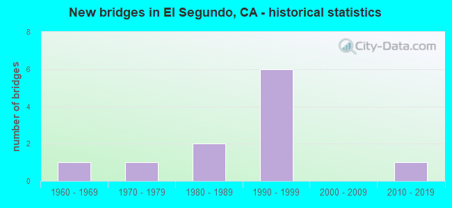
- New bridges - historical statistics
- 11960-1969
- 11970-1979
- 21980-1989
- 61990-1999
- 12010-2019

Find on map >> Show street view
Structure Number: 53 2400S, Location: 07-LA-105-R0.85-ESEG (Lat: 33.930694, Lng: -118.390206), Route carried "on" structure: Ramp Interstate 105, Year Built: 1989, Status: Open, Structure Length: 16.54m (54.27ft), Average Daily Traffic: 10,400 (year 2011), Truck Traffic: 1%, Average Future Daily Traffic: 12,145 (year 2040), Design Load: HS 20+Mod, Features Intersected: IMPERIAL HWY EB, Facility Carried by Structure: IMP HWY EB ONRMP
Minimum Vertical Clearance: 30+ m (98+ ft), Kilometerpoint: 0.850, Lanes on structure: 1, Lanes under structure: 3, Base Highway Network: Yes, Owner: State Highway Agency, Approaching Roadway Width: 9.8m (32.2ft), Material/Design: Prestressed concrete continuous, Design/Construction: Box Beam or Girders - Multiple, Number Of Spans In Main Unit: 4, Length of Maximum Span: 46.2m (151.6ft), Curb-To-Curb Width: 9.8m (32.2ft), Out-to-Out Width: 10.9m (35.8ft)
Condition: Deck: Good, Superstructure: Good, Substructure: Good, Operating Rating: 54.1 metric tons, Method Used To Determine Operating Rating: Assigned rating based on Load Factor Design (LFD) reported in metric tons, Inventory Rating: 32.4 metric tons, Method Used To Determine Inventory Rating: Assigned rating based on Load Factor Design (LFD) reported in metric tons, Structural Evaluation: Better than present minimum criteria, Deck Geometry: Superior to present desirable criteria, Underclear: Equal to present minimum criteria, Approach Roadway Alignment: Better than present minimum criteria, Designated Inspection Frequency: Every 24 months, Inspection Date: March 2020, Deck Structure Type: Concrete Cast-file-Place, Wearing Surface/Protective System: Wearing Surface: Monolithic Concrete
Find on map >> Show street view
Structure Number: 53C2241, Location: 0.26 MI W. OF LA CIENEGA (Lat: 34.026567, Lng: -118.376992), Route carried "on" structure: City street , Year Built: 2010, Status: Open, Structure Length: 5.06m (16.60ft), Average Daily Traffic: 8,000 (year 2012), Truck Traffic: 3%, Average Future Daily Traffic: 12,531 (year 2039), Design Load: HL 93, Features Intersected: BALLONA CREEK, Facility Carried by Structure: NATIONAL BLVD
Minimum Vertical Clearance: 30+ m (98+ ft), Kilometerpoint: 0.000, Lanes on structure: 4, Base Highway Network: Yes, Owner: City or Municipal Highway Agency, Approaching Roadway Width: 16.9m (55.4ft), Skew: 10 degrees, Material/Design: Prestressed concrete, Design/Construction: Stringer/Multi-beam, Number Of Spans In Main Unit: 1, Number Of Approach Spans: 2, Length of Maximum Span: 50.6m (166.0ft), Curb or Sidewalk Widths: Left: 0.0m, Right: 2.4m (7.9ft), Curb-To-Curb Width: 17.0m (55.8ft), Out-to-Out Width: 23.7m (77.8ft)
Condition: Deck: Good, Superstructure: Good, Substructure: Good, Channel: Excellent, Operating Rating: 42.1 metric tons, Method Used To Determine Operating Rating: Assigned ratings based on Load and Resistance Factor Design (LRFD) reported by rating factor (RF) using HL93 loadings, Inventory Rating: 32.4 metric tons, Method Used To Determine Inventory Rating: Assigned ratings based on Load and Resistance Factor Design (LRFD) reported by rating factor (RF) using HL93 loadings, Structural Evaluation: Better than present minimum criteria, Deck Geometry: Somewhat better than minimum adequacy, Waterway Adequacy: Superior to present desirable criteria, Approach Roadway Alignment: Equal to present desirable criteria, Designated Inspection Frequency: Every 24 months, Inspection Date: March 2020, Deck Structure Type: Concrete Cast-file-Place
Find on map >> Show street view
Structure Number: 53 124, Location: 07-LA-405-R20.73-ESEG (Lat: 33.923694, Lng: -118.368364), Route carried "under" structure: City street , Year Built: 1963, Structure Length: 0. m, Average Daily Traffic: 1,000 (year 2015), Truck Traffic: 2%, Features Intersected: 120TH STREET, Facility Carried by Structure: INTERSTATE 405
Minimum Vertical Clearance: 4.83m (15.85ft), Kilometerpoint: 0.000, Lanes on structure: 12, Lanes under structure: 4, Material/Design: Concrete continuous, Design/Construction: Box Beam or Girders - Multiple, Length of Maximum Span: 25.9m (85.0ft)
Find on map >> Show street view
Structure Number: 53 2400S, Location: 07-LA-105-R0.85-ESEG (Lat: 33.930694, Lng: -118.390206), Route carried "under" structure: City street L100, Year Built: 1989, Structure Length: 0. m, Average Daily Traffic: 22,000 (year 2006), Truck Traffic: 1%, Features Intersected: IMPERIAL HWY EB, Facility Carried by Structure: IMP HWY EB ONRMP
Minimum Vertical Clearance: 5.63m (18.47ft), Kilometerpoint: 0.000, Lanes on structure: 1, Lanes under structure: 3, Material/Design: Prestressed concrete continuous, Design/Construction: Box Beam or Girders - Multiple, Length of Maximum Span: 46.2m (151.6ft)
Find on map >> Show street view
Structure Number: 53C0842, Location: 20FT W/O AVIATION BLVD (Lat: 33.916131, Lng: -118.378714), Route carried "under" structure: City street L080, Year Built: 1975, Structure Length: 0. m, Average Daily Traffic: 43,107 (year 2012), Truck Traffic: 4%, Features Intersected: EL SEGUNDO BLVD UP, Facility Carried by Structure: BNSF
Minimum Vertical Clearance: 4.55m (14.93ft), Kilometerpoint: 0.000, Lanes under structure: 9, Material/Design: Steel, Design/Construction: Girder and Floorbeam System, Length of Maximum Span: 28.7m (94.2ft)
Find on map >> Show street view
Structure Number: 53C2018, Location: 0.5MI E/O SEPULVEDA BLVD (Lat: 33.916231, Lng: -118.386703), Route carried "under" structure: City street L080, Year Built: 1993, Structure Length: 0. m, Average Daily Traffic: 36,396 (year 2012), Truck Traffic: 4%, Features Intersected: EL SEGUNDO BLVD, Facility Carried by Structure: MTA GREEN LINE LRT
Minimum Vertical Clearance: 6.16m (20.21ft), Kilometerpoint: 0.000, Lanes under structure: 8, Material/Design: Concrete, Design/Construction: Box Beam or Girders - Single/Spread, Length of Maximum Span: 38.5m (126.3ft)
Find on map >> Show street view
Structure Number: 53C2242, Location: 100FT N/O EL SEGUNDO BLVD (Lat: 33.916806, Lng: -118.387297), Route carried "under" structure: City street , Year Built: 1993, Structure Length: 0. m, Average Daily Traffic: 36,396 (year 2012), Truck Traffic: 1%, Features Intersected: NASH ST S/XING, Facility Carried by Structure: MTA GREEN LINE LRT
Minimum Vertical Clearance: 5.70m (18.70ft), Kilometerpoint: 0.000, Lanes under structure: 5, Material/Design: Concrete, Design/Construction: Box Beam or Girders - Single/Spread, Length of Maximum Span: 42.0m (137.8ft)
Find on map >> Show street view
Structure Number: 53C2243, Location: 40FT W/O NASH ST (Lat: 33.919594, Lng: -118.387475), Route carried "under" structure: City street , Year Built: 1993, Structure Length: 0. m, Average Daily Traffic: 34,711 (year 2012), Features Intersected: GRAND AVE, Facility Carried by Structure: MTA GREEN LINE LRT
Minimum Vertical Clearance: 5.55m (18.21ft), Kilometerpoint: 0.000, Lanes under structure: 6, Material/Design: Concrete, Design/Construction: Box Beam or Girders - Single/Spread, Length of Maximum Span: 40.0m (131.2ft)
Find on map >> Show street view
Structure Number: 53C2244, Location: 40FT W/O NASH ST (Lat: 33.923517, Lng: -118.387472), Route carried "under" structure: City street , Year Built: 1993, Structure Length: 0. m, Average Daily Traffic: 36,396 (year 2012), Features Intersected: MARIPOSA AVE, Facility Carried by Structure: MTA GREEN LINE LRT
Minimum Vertical Clearance: 5.44m (17.85ft), Kilometerpoint: 0.000, Lanes under structure: 6, Material/Design: Concrete, Design/Construction: Box Beam or Girders - Single/Spread, Length of Maximum Span: 41.8m (137.1ft)
Find on map >> Show street view
Structure Number: 53C2247, Location: 0.1MI S/O IMPERIAL (Lat: 33.929222, Lng: -118.383300), Route carried "under" structure: City street , Year Built: 1993, Structure Length: 0. m, Average Daily Traffic: 36,396 (year 2012), Truck Traffic: 1%, Features Intersected: DOUGLAS ST, Facility Carried by Structure: MTA GREEN LINE LRT
Minimum Vertical Clearance: 6.86m (22.51ft), Kilometerpoint: 0.000, Lanes under structure: 6, Material/Design: Concrete, Design/Construction: Box Beam or Girders - Single/Spread, Length of Maximum Span: 39.3m (128.9ft)
Find on map >> Show street view
Structure Number: 53C2248, Location: 0.3MI S/O IMPERIAL HWY (Lat: 33.926850, Lng: -118.387475), Route carried "under" structure: City street , Year Built: 1993, Structure Length: 0. m, Average Daily Traffic: 36,396 (year 2012), Truck Traffic: 1%, Features Intersected: NASH ST / E MAPLE AVE, Facility Carried by Structure: MTA GREEN LINE LRT
Minimum Vertical Clearance: 4.77m (15.65ft), Kilometerpoint: 0.000, Lanes under structure: 4, Material/Design: Concrete, Design/Construction: Box Beam or Girders - Single/Spread, Length of Maximum Span: 40.1m (131.6ft)