Bridge Statistics for Fortuna, California (CA)
Condition, Traffic, Stress, Structural Evaluation, Project Costs
- National Bridge Inventory (NBI) Statistics
- 25Number of bridges
- 210ft / 63.9mTotal length
- $1,204,000Total costs
- 208,137Total average daily traffic
- 19,909Total average daily truck traffic
- National Bridge Inventory (NBI) Registered Bridges for Fortuna
- No street view available for this location
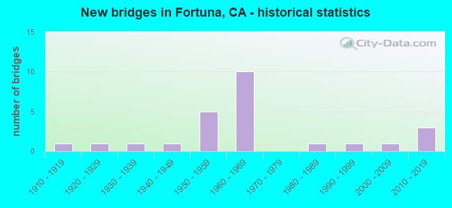
- New bridges - historical statistics
- 11910-1919
- 11920-1929
- 11930-1939
- 11940-1949
- 51950-1959
- 101960-1969
- 11980-1989
- 11990-1999
- 12000-2009
- 32010-2019

- Reconstructed bridges - Historical Statistics
- 11940-1949
- 01950-1959
- 01960-1969
- 11970-1979
- 31980-1989
- 01990-1999
- 22000-2009


- Bridge Condition - Deck
- 82.4%Good
- 5.9%Satisfactory
- 11.8%Fair

- Bridge Condition - Superstructure
- 64.7%Good
- 11.8%Satisfactory
- 17.6%Fair
- 5.9%Poor

- Bridge Condition - Substructure
- 88.2%Good
- 5.9%Satisfactory
- 5.9%Fair

- Bridge Condition - Channel
- 33.3%Excellent
- 26.7%Very good
- 13.3%Good
- 20.0%Satisfactory
- 6.7%Fair

- Bridge Condition - Culverts
- 75.0%Satisfactory
- 25.0%Fair
Find on map >> Show street view
Structure Number: 4 0031L, Location: 01-HUM-101-57.36 (Lat: 40.543747, Lng: -124.144569), Route carried "on" structure: US 101, Year Built: 1952, Year Reconstructed: 1992, Status: Open, Structure Length: 1.92m (6.30ft), Average Daily Traffic: 4,400 (year 2009), Truck Traffic: 12%, Average Future Daily Traffic: 6,453 (year 2039), Design Load: HS 20, Features Intersected: VAN DUZEN RIVER OVERFLOW
Minimum Vertical Clearance: 30+ m (98+ ft), Kilometerpoint: 57.360, Lanes on structure: 2, Base Highway Network: Yes (Inventory Route: 1, Subroute: 1), Owner: State Highway Agency, Approaching Roadway Width: 11.9m (39.0ft), Material/Design: Concrete continuous, Design/Construction: Slab, Number Of Spans In Main Unit: 3, Length of Maximum Span: 7.3m (24.0ft), Curb-To-Curb Width: 11.9m (39.0ft), Out-to-Out Width: 12.8m (42.0ft)
Condition: Deck: Good, Superstructure: Good, Substructure: Good, Channel: Very good, Operating Rating: 52.8 metric tons, Method Used To Determine Operating Rating: Load Factor (LF), Inventory Rating: 31.8 metric tons, Method Used To Determine Inventory Rating: Load Factor (LF), Structural Evaluation: Better than present minimum criteria, Deck Geometry: Equal to present minimum criteria, Waterway Adequacy: Equal to present desirable criteria, Approach Roadway Alignment: Equal to present desirable criteria, Designated Inspection Frequency: Every 24 months, Inspection Date: July 2021, Deck Structure Type: Concrete Cast-file-Place, Wearing Surface/Protective System: Wearing Surface: Bituminous
Find on map >> Show street view
Structure Number: 4 0031R, Location: 01-HUM-101-57.36 (Lat: 40.543767, Lng: -124.144389), Route carried "on" structure: US 101, Year Built: 1952, Year Reconstructed: 1992, Status: Open, Structure Length: 1.92m (6.30ft), Average Daily Traffic: 4,400 (year 2009), Truck Traffic: 12%, Average Future Daily Traffic: 6,453 (year 2039), Design Load: HS 20, Features Intersected: VAN DUZEN RIVER OVERFLOW
Minimum Vertical Clearance: 30+ m (98+ ft), Kilometerpoint: 57.360, Lanes on structure: 2, Base Highway Network: Yes (Inventory Route: 1, Subroute: 1), Owner: State Highway Agency, Approaching Roadway Width: 11.9m (39.0ft), Material/Design: Concrete continuous, Design/Construction: Slab, Number Of Spans In Main Unit: 3, Length of Maximum Span: 7.3m (24.0ft), Curb-To-Curb Width: 11.9m (39.0ft), Out-to-Out Width: 12.8m (42.0ft)
Condition: Deck: Good, Superstructure: Good, Substructure: Good, Channel: Very good, Operating Rating: 52.8 metric tons, Method Used To Determine Operating Rating: Load Factor (LF), Inventory Rating: 31.8 metric tons, Method Used To Determine Inventory Rating: Load Factor (LF), Structural Evaluation: Better than present minimum criteria, Deck Geometry: Equal to present minimum criteria, Waterway Adequacy: Equal to present desirable criteria, Approach Roadway Alignment: Equal to present desirable criteria, Designated Inspection Frequency: Every 24 months, Inspection Date: July 2021, Deck Structure Type: Concrete Cast-file-Place, Wearing Surface/Protective System: Wearing Surface: Bituminous
Find on map >> Show street view
Structure Number: 4 0107, Location: 01-HUM-101-59.94 (Lat: 40.580717, Lng: -124.150600), Route carried "on" structure: US 101, Year Built: 1962, Status: Open, Structure Length: 1.22m (4.00ft), Average Daily Traffic: 13,000 (year 2009), Truck Traffic: 10%, Average Future Daily Traffic: 27,041 (year 2041), Design Load: HS 20, Features Intersected: STRONGS CREEK
Minimum Vertical Clearance: 30+ m (98+ ft), Kilometerpoint: 59.940, Lanes on structure: 4, Base Highway Network: Yes (Inventory Route: 1, Subroute: 1), Owner: State Highway Agency, Approaching Roadway Width: 11.3m (37.1ft), Skew: 24 degrees, Material/Design: Concrete, Design/Construction: Culvert, Number Of Spans In Main Unit: 1, Length of Maximum Span: 11.9m (39.0ft), Curb-To-Curb Width: 26.1m (85.6ft), Out-to-Out Width: 27.0m (88.6ft)
Condition: Channel: Satisfactory, Culverts: Satisfactory, Operating Rating: 70.0 metric tons, Method Used To Determine Operating Rating: Load Factor (LF), Inventory Rating: 42.1 metric tons, Method Used To Determine Inventory Rating: Load Factor (LF), Structural Evaluation: Equal to present minimum criteria, Deck Geometry: Superior to present desirable criteria, Waterway Adequacy: Equal to present desirable criteria, Approach Roadway Alignment: Equal to present desirable criteria, Designated Inspection Frequency: Every 24 months, Inspection Date: July 2021, Deck Structure Type: Concrete Cast-file-Place, Wearing Surface/Protective System: Wearing Surface: Bituminous
Find on map >> Show street view
Structure Number: 4 0108, Location: 01-HUM-101-60.67 (Lat: 40.590244, Lng: -124.156639), Route carried "on" structure: US 101, Year Built: 1962, Status: Open, Structure Length: 2.65m (8.69ft), Average Daily Traffic: 15,000 (year 2009), Truck Traffic: 10%, Average Future Daily Traffic: 27,041 (year 2041), Design Load: HS 20, Features Intersected: ROHNER CREEK
Minimum Vertical Clearance: 30+ m (98+ ft), Kilometerpoint: 60.670, Lanes on structure: 4, Base Highway Network: Yes (Inventory Route: 1, Subroute: 1), Owner: State Highway Agency, Approaching Roadway Width: 22.5m (73.8ft), Skew: 32 degrees, Material/Design: Concrete continuous, Design/Construction: Slab, Number Of Spans In Main Unit: 3, Length of Maximum Span: 8.5m (27.9ft), Curb-To-Curb Width: 22.6m (74.1ft), Out-to-Out Width: 27.0m (88.6ft)
Condition: Deck: Fair, Superstructure: Poor, Substructure: Good, Channel: Very good, Operating Rating: 67.4 metric tons, Method Used To Determine Operating Rating: Load Factor (LF), Inventory Rating: 40.5 metric tons, Method Used To Determine Inventory Rating: Load Factor (LF), Structural Evaluation: Meets minimum limits, Deck Geometry: Superior to present desirable criteria, Waterway Adequacy: Equal to present desirable criteria, Approach Roadway Alignment: Equal to present desirable criteria, Length Of Structure Improvement: 2.65m (8.69ft), Designated Inspection Frequency: Every 24 months, Inspection Date: July 2021, Bridge Improvement Cost: $717,000, Roadway Improvement Cost: $143,000, Total Project Cost: $1,204,000 ( Estimate for 2020), Deck Structure Type: Concrete Cast-file-Place
Find on map >> Show street view
Structure Number: 4 0112L, Location: 01-HUM-101-62.23 (Lat: 40.604861, Lng: -124.178083), Route carried "on" structure: US 101, Year Built: 1958, Year Reconstructed: 2005, Status: Open, Structure Length: 3.44m (11.29ft), Average Daily Traffic: 22,000 (year 2009), Truck Traffic: 10%, Average Future Daily Traffic: 27,041 (year 2041), Design Load: HS 20, Features Intersected: PALMER BLVD
Minimum Vertical Clearance: 30+ m (98+ ft), Kilometerpoint: 62.230, Lanes on structure: 2, Lanes under structure: 2, Base Highway Network: Yes (Inventory Route: 1, Subroute: 1), Owner: State Highway Agency, Approaching Roadway Width: 12.1m (39.7ft), Material/Design: Concrete continuous, Design/Construction: Tee Beam, Number Of Spans In Main Unit: 3, Length of Maximum Span: 14.3m (46.9ft), Curb-To-Curb Width: 12.1m (39.7ft), Out-to-Out Width: 13.0m (42.7ft)
Condition: Deck: Good, Superstructure: Fair, Substructure: Good, Operating Rating: 35.6 metric tons, Method Used To Determine Operating Rating: Load and Resistance Factor Rating (LRFR) rating reported by rating factor(RF) method using HL-93 loadings, Inventory Rating: 26.9 metric tons, Method Used To Determine Inventory Rating: Load and Resistance Factor Rating (LRFR) rating reported by rating factor(RF) method using HL-93 loadings, Structural Evaluation: Somewhat better than minimum adequacy, Deck Geometry: Better than present minimum criteria, Underclear: Equal to present minimum criteria, Approach Roadway Alignment: Equal to present desirable criteria, Designated Inspection Frequency: Every 24 months, Inspection Date: July 2021, Deck Structure Type: Concrete Cast-file-Place, Wearing Surface/Protective System: Wearing Surface: Integral Concrete
Find on map >> Show street view
Structure Number: 4 0112R, Location: 01-HUM-101-62.23 (Lat: 40.604972, Lng: -124.178000), Route carried "on" structure: State highway 101, Year Built: 1958, Year Reconstructed: 2005, Status: Open, Structure Length: 3.44m (11.29ft), Average Daily Traffic: 22,000 (year 2009), Truck Traffic: 10%, Average Future Daily Traffic: 27,041 (year 2041), Design Load: HS 20, Features Intersected: PALMER BLVD
Minimum Vertical Clearance: 30+ m (98+ ft), Kilometerpoint: 62.230, Lanes on structure: 2, Lanes under structure: 2, Base Highway Network: Yes (Inventory Route: 1, Subroute: 1), Owner: State Highway Agency, Approaching Roadway Width: 12.1m (39.7ft), Material/Design: Concrete continuous, Design/Construction: Tee Beam, Number Of Spans In Main Unit: 3, Length of Maximum Span: 14.3m (46.9ft), Curb-To-Curb Width: 12.1m (39.7ft), Out-to-Out Width: 13.0m (42.7ft)
Condition: Deck: Good, Superstructure: Fair, Substructure: Good, Operating Rating: 35.6 metric tons, Method Used To Determine Operating Rating: Load and Resistance Factor Rating (LRFR) rating reported by rating factor(RF) method using HL-93 loadings, Inventory Rating: 26.9 metric tons, Method Used To Determine Inventory Rating: Load and Resistance Factor Rating (LRFR) rating reported by rating factor(RF) method using HL-93 loadings, Structural Evaluation: Somewhat better than minimum adequacy, Deck Geometry: Better than present minimum criteria, Underclear: Equal to present minimum criteria, Approach Roadway Alignment: Equal to present desirable criteria, Designated Inspection Frequency: Every 24 months, Inspection Date: July 2021, Deck Structure Type: Concrete Cast-file-Place, Wearing Surface/Protective System: Wearing Surface: Integral Concrete
Find on map >> Show street view
Structure Number: 4 0128, Location: 01-HUM-101-59.50-FTA (Lat: 40.574731, Lng: -124.148867), Route carried "on" structure: US 101, Year Built: 1962, Status: Open, Structure Length: 4.02m (13.19ft), Average Daily Traffic: 17,900 (year 2010), Truck Traffic: 10%, Average Future Daily Traffic: 27,041 (year 2041), Design Load: HS 20, Features Intersected: KENMAR ROAD
Minimum Vertical Clearance: 30+ m (98+ ft), Kilometerpoint: 59.500, Lanes on structure: 4, Lanes under structure: 2, Base Highway Network: Yes (Inventory Route: 1, Subroute: 1), Owner: State Highway Agency, Approaching Roadway Width: 25.6m (84.0ft), Skew: 33 degrees, Material/Design: Concrete continuous, Design/Construction: Tee Beam, Number Of Spans In Main Unit: 3, Length of Maximum Span: 19.5m (64.0ft), Curb-To-Curb Width: 25.6m (84.0ft), Out-to-Out Width: 27.0m (88.6ft)
Condition: Deck: Good, Superstructure: Good, Substructure: Good, Operating Rating: 38.6 metric tons, Method Used To Determine Operating Rating: Load and Resistance Factor Rating (LRFR) rating reported by rating factor(RF) method using HL-93 loadings, Inventory Rating: 29.8 metric tons, Method Used To Determine Inventory Rating: Load and Resistance Factor Rating (LRFR) rating reported by rating factor(RF) method using HL-93 loadings, Structural Evaluation: Better than present minimum criteria, Deck Geometry: Superior to present desirable criteria, Underclear: Equal to present minimum criteria, Approach Roadway Alignment: Equal to present desirable criteria, Designated Inspection Frequency: Every 24 months, Inspection Date: July 2021, Deck Structure Type: Concrete Cast-file-Place, Wearing Surface/Protective System: Wearing Surface: Integral Concrete
Find on map >> Show street view
Structure Number: 4 013, Location: 01-HUM-101-60.49 (Lat: 40.587644, Lng: -124.155422), Route carried "on" structure: County highway , Year Built: 1962, Status: Open, Structure Length: 6.00m (19.69ft), Average Daily Traffic: 2,500 (year 2010), Truck Traffic: 10%, Average Future Daily Traffic: 1,664 (year 2043), Design Load: HS 20, Features Intersected: U.S. HIGHWAY 101, Facility Carried by Structure: TWELFTH ST
Minimum Vertical Clearance: 30+ m (98+ ft), Kilometerpoint: 0.000, Lanes on structure: 2, Lanes under structure: 4, Owner: State Highway Agency, Approaching Roadway Width: 9.4m (30.8ft), Skew: 9 degrees, Material/Design: Concrete continuous, Design/Construction: Tee Beam, Number Of Spans In Main Unit: 4, Length of Maximum Span: 19.8m (65.0ft), Curb or Sidewalk Widths: Left: 0.6m (2.0ft), Right: 0.6m (2.0ft), Curb-To-Curb Width: 8.5m (27.9ft), Out-to-Out Width: 10.4m (34.1ft)
Condition: Deck: Good, Superstructure: Good, Substructure: Good, Operating Rating: 43.1 metric tons, Method Used To Determine Operating Rating: Load and Resistance Factor Rating (LRFR) rating reported by rating factor(RF) method using HL-93 loadings, Inventory Rating: 33.4 metric tons, Method Used To Determine Inventory Rating: Load and Resistance Factor Rating (LRFR) rating reported by rating factor(RF) method using HL-93 loadings, Structural Evaluation: Better than present minimum criteria, Deck Geometry: Meets minimum limits, Underclear: Meets minimum limits, Approach Roadway Alignment: Equal to present desirable criteria, Designated Inspection Frequency: Every 24 months, Inspection Date: July 2021, Deck Structure Type: Concrete Cast-file-Place
Find on map >> Show street view
Structure Number: 4 0145, Location: 01-HUM-101-61.53-FTA (Lat: 40.598894, Lng: -124.167267), Route carried "on" structure: US 101, Year Built: 1962, Year Reconstructed: 1993, Status: Open, Structure Length: 13.93m (45.70ft), Average Daily Traffic: 12,800 (year 2009), Truck Traffic: 11%, Average Future Daily Traffic: 16,340 (year 2039), Design Load: HS 20+Mod, Features Intersected: S101-MAIN ON&OFF,NCRRA
Minimum Vertical Clearance: 30+ m (98+ ft), Kilometerpoint: 61.530, Lanes on structure: 4, Lanes under structure: 2, Base Highway Network: Yes (Inventory Route: 1, Subroute: 1), Owner: State Highway Agency, Approaching Roadway Width: 22.6m (74.1ft), Skew: 30 degrees, Material/Design: Concrete continuous, Design/Construction: Tee Beam, Number Of Spans In Main Unit: 6, Length of Maximum Span: 31.4m (103.0ft), Curb or Sidewalk Widths: Left: 0.6m (2.0ft), Right: 0.6m (2.0ft), Curb-To-Curb Width: 22.6m (74.1ft), Out-to-Out Width: 24.4m (80.1ft)
Condition: Deck: Good, Superstructure: Good, Substructure: Good, Operating Rating: 31.8 metric tons, Method Used To Determine Operating Rating: Load and Resistance Factor Rating (LRFR) rating reported by rating factor(RF) method using HL-93 loadings, Inventory Rating: 21.4 metric tons, Method Used To Determine Inventory Rating: Load and Resistance Factor Rating (LRFR) rating reported by rating factor(RF) method using HL-93 loadings, Structural Evaluation: Somewhat better than minimum adequacy, Deck Geometry: Superior to present desirable criteria, Underclear: Meets minimum limits, Approach Roadway Alignment: Equal to present desirable criteria, Designated Inspection Frequency: Every 24 months, Inspection Date: July 2021, Deck Structure Type: Concrete Cast-file-Place, Wearing Surface/Protective System: Wearing Surface: Integral Concrete
Find on map >> Show street view
Structure Number: 4 0287Y, Location: 01-HUM-000-0.00 (Lat: 40.543700, Lng: -124.144881), Route carried "on" structure: County highway , Year Built: 2009, Status: Open, Structure Length: 2.40m (7.87ft), Average Daily Traffic: 30 (year 2012), Truck Traffic: 10%, Average Future Daily Traffic: 48 (year 2043), Design Load: HL 93, Features Intersected: VAN DUZEN RIVER OVERFLOW, Facility Carried by Structure: SANDY PRAIRIE ROAD
Minimum Vertical Clearance: 30+ m (98+ ft), Kilometerpoint: 0.000, Lanes on structure: 2, Owner: State Highway Agency, Approaching Roadway Width: 9.6m (31.5ft), Material/Design: Concrete continuous, Design/Construction: Slab, Number Of Spans In Main Unit: 3, Length of Maximum Span: 9.6m (31.5ft), Curb-To-Curb Width: 9.6m (31.5ft), Out-to-Out Width: 10.5m (34.4ft)
Condition: Deck: Good, Superstructure: Good, Substructure: Good, Channel: Excellent, Operating Rating: 42.1 metric tons, Method Used To Determine Operating Rating: Assigned ratings based on Load and Resistance Factor Design (LRFD) reported by rating factor (RF) using HL93 loadings, Inventory Rating: 32.4 metric tons, Method Used To Determine Inventory Rating: Assigned ratings based on Load and Resistance Factor Design (LRFD) reported by rating factor (RF) using HL93 loadings, Structural Evaluation: Better than present minimum criteria, Deck Geometry: Better than present minimum criteria, Waterway Adequacy: Equal to present desirable criteria, Approach Roadway Alignment: Equal to present desirable criteria, Designated Inspection Frequency: Every 48 months, Inspection Date: July 2021, Deck Structure Type: Concrete Cast-file-Place
Find on map >> Show street view
Structure Number: 4 0301, Location: 01-HUM-036-0.01 (Lat: 40.548567, Lng: -124.145700), Route carried "on" structure: State highway 36, Year Built: 2010, Status: Open, Structure Length: 5.13m (16.83ft), Average Daily Traffic: 4,000 (year 2009), Truck Traffic: 18%, Average Future Daily Traffic: 4,996 (year 2042), Design Load: HL 93, Features Intersected: US HIGHWAY 101
Minimum Vertical Clearance: 30+ m (98+ ft), Kilometerpoint: 0.010, Lanes on structure: 2, Lanes under structure: 4, Base Highway Network: Yes (, Subroute: 1), Owner: State Highway Agency, Approaching Roadway Width: 15.7m (51.5ft), Material/Design: Prestressed concrete continuous, Design/Construction: Box Beam or Girders - Multiple, Number Of Spans In Main Unit: 2, Length of Maximum Span: 25.0m (82.0ft), Curb or Sidewalk Widths: Left: 1.5m (4.9ft), Right: 0.0m, Curb-To-Curb Width: 15.7m (51.5ft), Out-to-Out Width: 17.8m (58.4ft)
Condition: Deck: Good, Superstructure: Good, Substructure: Good, Operating Rating: 42.1 metric tons, Method Used To Determine Operating Rating: Assigned ratings based on Load and Resistance Factor Design (LRFD) reported by rating factor (RF) using HL93 loadings, Inventory Rating: 32.4 metric tons, Method Used To Determine Inventory Rating: Assigned ratings based on Load and Resistance Factor Design (LRFD) reported by rating factor (RF) using HL93 loadings, Structural Evaluation: Better than present minimum criteria, Deck Geometry: Superior to present desirable criteria, Underclear: Superior to present desirable criteria, Approach Roadway Alignment: Equal to present desirable criteria, Designated Inspection Frequency: Every 24 months, Inspection Date: June 2020, Deck Structure Type: Concrete Cast-file-Place
Find on map >> Show street view
Structure Number: 4C0085, Location: 0.9 MI NORTH OF HWY 101 (Lat: 40.585461, Lng: -124.154536), Route carried "on" structure: County highway , Year Built: 1962, Status: Open, Structure Length: 3.00m (9.84ft), Average Daily Traffic: 2,322 (year 2014), Truck Traffic: 3%, Average Future Daily Traffic: 4,500 (year 2040), Design Load: HS 20, Features Intersected: STRONGS CREEK, Facility Carried by Structure: RIVERWALK DRIVE
Minimum Vertical Clearance: 30+ m (98+ ft), Kilometerpoint: 0.000, Lanes on structure: 2, Owner: County Highway Agency, Approaching Roadway Width: 8.5m (27.9ft), Skew: 1 degrees, Material/Design: Concrete continuous, Design/Construction: Slab, Number Of Spans In Main Unit: 3, Length of Maximum Span: 9.8m (32.2ft), Curb-To-Curb Width: 8.5m (27.9ft), Out-to-Out Width: 8.7m (28.5ft)
Condition: Deck: Fair, Superstructure: Fair, Substructure: Good, Channel: Excellent, Operating Rating: 37.9 metric tons, Method Used To Determine Operating Rating: Load and Resistance Factor Rating (LRFR) rating reported by rating factor(RF) method using HL-93 loadings, Inventory Rating: 26.9 metric tons, Method Used To Determine Inventory Rating: Load and Resistance Factor Rating (LRFR) rating reported by rating factor(RF) method using HL-93 loadings, Structural Evaluation: Somewhat better than minimum adequacy, Deck Geometry: Meets minimum limits, Waterway Adequacy: Equal to present desirable criteria, Approach Roadway Alignment: Equal to present desirable criteria, Designated Inspection Frequency: Every 24 months, Inspection Date: August 2020, Deck Structure Type: Concrete Cast-file-Place
Find on map >> Show street view
Structure Number: 4C01, Location: 0.2 MI N/O KENMAR RD (Lat: 40.580303, Lng: -124.146656), Route carried "on" structure: City street , Year Built: 1949, Status: Open, Structure Length: 0.90m (2.95ft), Average Daily Traffic: 11,988 (year 2011), Truck Traffic: 5%, Average Future Daily Traffic: 15,405 (year 2040), Design Load: HS 20, Features Intersected: STRONGS CREEK, Facility Carried by Structure: FORTUNA BOULEVARD
Minimum Vertical Clearance: 30+ m (98+ ft), Kilometerpoint: 0.000, Lanes on structure: 5, Base Highway Network: Yes, Owner: City or Municipal Highway Agency, Approaching Roadway Width: 19.8m (65.0ft), Skew: 24 degrees, Material/Design: Concrete, Design/Construction: Culvert, Number Of Spans In Main Unit: 1, Length of Maximum Span: 8.5m (27.9ft)
Condition: Channel: Excellent, Culverts: Fair, Operating Rating: 54.1 metric tons, Method Used To Determine Operating Rating: Field evaluation and documented engineering judgment, Inventory Rating: 32.4 metric tons, Method Used To Determine Inventory Rating: Field evaluation and documented engineering judgment, Structural Evaluation: Somewhat better than minimum adequacy, Waterway Adequacy: Better than present minimum criteria, Approach Roadway Alignment: Equal to present desirable criteria, Designated Inspection Frequency: Every 24 months, Inspection Date: August 2020
Find on map >> Show street view
Structure Number: 4C0102, Location: 0.3 MI N INT WTH 12TH ST (Lat: 40.590072, Lng: -124.157061), Route carried "on" structure: City street , Year Built: 1962, Status: Open, Structure Length: 2.65m (8.69ft), Average Daily Traffic: 556 (year 2011), Truck Traffic: 2%, Average Future Daily Traffic: 320 (year 2035), Design Load: H 20, Features Intersected: ROHNER CREEK, Facility Carried by Structure: DINSMORE DRIVE
Minimum Vertical Clearance: 30+ m (98+ ft), Kilometerpoint: 0.000, Lanes on structure: 2, Owner: City or Municipal Highway Agency, Approaching Roadway Width: 7.9m (25.9ft), Skew: 1 degrees, Material/Design: Concrete continuous, Design/Construction: Slab, Number Of Spans In Main Unit: 3, Length of Maximum Span: 8.5m (27.9ft), Curb-To-Curb Width: 7.9m (25.9ft), Out-to-Out Width: 8.7m (28.5ft)
Condition: Deck: Good, Superstructure: Good, Substructure: Good, Channel: Satisfactory, Operating Rating: 71.0 metric tons, Method Used To Determine Operating Rating: Load Factor (LF), Inventory Rating: 42.8 metric tons, Method Used To Determine Inventory Rating: Load Factor (LF), Structural Evaluation: Better than present minimum criteria, Deck Geometry: Somewhat better than minimum adequacy, Waterway Adequacy: Better than present minimum criteria, Approach Roadway Alignment: Equal to present desirable criteria, Designated Inspection Frequency: Every 48 months, Inspection Date: August 2018, Deck Structure Type: Concrete Cast-file-Place
Find on map >> Show street view
Structure Number: 4C0103, Location: JUST EAST OF 16TH STREET (Lat: 40.597794, Lng: -124.150106), Route carried "on" structure: City street , Year Built: 1922, Year Reconstructed: 1948, Status: Open, Structure Length: 0.80m (2.62ft), Average Daily Traffic: 11,181 (year 2011), Truck Traffic: 5%, Average Future Daily Traffic: 11,184 (year 2040), Features Intersected: ROHNER CREEK, Facility Carried by Structure: MAIN STREET
Minimum Vertical Clearance: 30+ m (98+ ft), Kilometerpoint: 0.000, Lanes on structure: 4, Base Highway Network: Yes, Owner: City or Municipal Highway Agency, Approaching Roadway Width: 18.4m (60.4ft), Skew: 9 degrees, Material/Design: Concrete, Design/Construction: Tee Beam, Number Of Spans In Main Unit: 1, Length of Maximum Span: 7.7m (25.3ft), Curb or Sidewalk Widths: Left: 2.0m (6.6ft), Right: 1.5m (4.9ft), Curb-To-Curb Width: 18.4m (60.4ft), Out-to-Out Width: 22.7m (74.5ft)
Condition: Deck: Satisfactory, Superstructure: Satisfactory, Substructure: Fair, Channel: Good, Operating Rating: 27.9 metric tons, Method Used To Determine Operating Rating: Field evaluation and documented engineering judgment, Inventory Rating: 16.5 metric tons, Method Used To Determine Inventory Rating: Field evaluation and documented engineering judgment, Structural Evaluation: Meets minimum limits, Deck Geometry: Somewhat better than minimum adequacy, Waterway Adequacy: Better than present minimum criteria, Approach Roadway Alignment: Equal to present desirable criteria, Designated Inspection Frequency: Every 24 months, Inspection Date: August 2020, Deck Structure Type: Concrete Cast-file-Place, Wearing Surface/Protective System: Wearing Surface: Bituminous
Find on map >> Show street view
Structure Number: 4C0197, Location: 0.8 MI NORTH OF MAIN ST (Lat: 40.608514, Lng: -124.147592), Route carried "on" structure: County highway , Year Built: 1959, Status: Open, Structure Length: 0.88m (2.89ft), Average Daily Traffic: 303 (year 2014), Truck Traffic: 5%, Average Future Daily Traffic: 1,000 (year 2040), Features Intersected: ROHNER CREEK, Facility Carried by Structure: CARSON WOODS ROAD
Minimum Vertical Clearance: 30+ m (98+ ft), Kilometerpoint: 0.000, Lanes on structure: 1, Owner: County Highway Agency, Approaching Roadway Width: 4.4m (14.4ft), Skew: 3 degrees, Material/Design: Concrete, Design/Construction: Slab, Number Of Spans In Main Unit: 1, Length of Maximum Span: 7.9m (25.9ft), Curb-To-Curb Width: 4.4m (14.4ft), Out-to-Out Width: 4.6m (15.1ft)
Condition: Deck: Good, Superstructure: Good, Substructure: Good, Channel: Fair, Operating Rating: 37.9 metric tons, Method Used To Determine Operating Rating: Field evaluation and documented engineering judgment, Inventory Rating: 22.7 metric tons, Method Used To Determine Inventory Rating: Field evaluation and documented engineering judgment, Structural Evaluation: Equal to present minimum criteria, Deck Geometry: High priority of replacement, Waterway Adequacy: Equal to present desirable criteria, Approach Roadway Alignment: Equal to present desirable criteria, Designated Inspection Frequency: Every 24 months, Inspection Date: August 2020, Deck Structure Type: Concrete Cast-file-Place
Find on map >> Show street view
Structure Number: 4C0211, Location: 0.3 MI W OF NEWBURG RD (Lat: 40.589711, Lng: -124.134614), Route carried "on" structure: City street , Year Built: 1915, Year Reconstructed: 1979, Status: Open, Structure Length: 1.28m (4.20ft), Average Daily Traffic: 4,924 (year 2011), Truck Traffic: 5%, Average Future Daily Traffic: 6,101 (year 2040), Features Intersected: STRONGS CREEK, Facility Carried by Structure: ROHNERVILLE ROAD
Minimum Vertical Clearance: 30+ m (98+ ft), Kilometerpoint: 0.000, Lanes on structure: 2, Owner: City or Municipal Highway Agency, Approaching Roadway Width: 9.8m (32.2ft), Material/Design: Concrete, Design/Construction: Tee Beam, Number Of Spans In Main Unit: 1, Length of Maximum Span: 12.0m (39.4ft), Curb-To-Curb Width: 9.8m (32.2ft), Out-to-Out Width: 10.0m (32.8ft)
Condition: Deck: Good, Superstructure: Satisfactory, Substructure: Satisfactory, Channel: Good, Operating Rating: 37.3 metric tons, Method Used To Determine Operating Rating: Load Factor (LF), Inventory Rating: 22.4 metric tons, Method Used To Determine Inventory Rating: Load Factor (LF), Structural Evaluation: Somewhat better than minimum adequacy, Deck Geometry: Meets minimum limits, Waterway Adequacy: Better than present minimum criteria, Approach Roadway Alignment: Equal to present desirable criteria, Designated Inspection Frequency: Every 24 months, Inspection Date: August 2020, Deck Structure Type: Concrete Cast-file-Place, Wearing Surface/Protective System: Wearing Surface: Bituminous
Find on map >> Show street view
Structure Number: 4C0235, Location: 0.1 MILE NORTH NEWBURG RD (Lat: 40.590900, Lng: -124.154436), Route carried "on" structure: City street , Year Built: 1935, Status: Open, Structure Length: 1.01m (3.31ft), Average Daily Traffic: 3,160 (year 2014), Truck Traffic: 5%, Average Future Daily Traffic: 6,500 (year 2037), Features Intersected: ROHNER CREEK, Facility Carried by Structure: 12TH ST
Minimum Vertical Clearance: 30+ m (98+ ft), Kilometerpoint: 0.000, Lanes on structure: 2, Owner: City or Municipal Highway Agency, Approaching Roadway Width: 14.5m (47.6ft), Material/Design: Concrete continuous, Design/Construction: Culvert, Number Of Spans In Main Unit: 3, Length of Maximum Span: 3.0m (9.8ft)
Condition: Channel: Excellent, Culverts: Satisfactory, Operating Rating: 27.2 metric tons, Method Used To Determine Operating Rating: Field evaluation and documented engineering judgment, Inventory Rating: 16.2 metric tons, Method Used To Determine Inventory Rating: Field evaluation and documented engineering judgment, Structural Evaluation: Meets minimum limits, Waterway Adequacy: Better than present minimum criteria, Approach Roadway Alignment: Equal to present desirable criteria, Designated Inspection Frequency: Every 24 months, Inspection Date: August 2020
Find on map >> Show street view
Structure Number: 4C0242, Location: 1/2 MI E FORTUNA BL (Lat: 40.583742, Lng: -124.137944), Route carried "on" structure: City street , Year Built: 1988, Status: Open, Structure Length: 1.92m (6.30ft), Average Daily Traffic: 4,353 (year 2014), Truck Traffic: 2%, Average Future Daily Traffic: 3,154 (year 2036), Design Load: HS 20, Features Intersected: STRONGS CREEK, Facility Carried by Structure: REDWOOD WAY
Minimum Vertical Clearance: 30+ m (98+ ft), Kilometerpoint: 0.000, Lanes on structure: 2, Owner: City or Municipal Highway Agency, Approaching Roadway Width: 9.1m (29.9ft), Material/Design: Concrete, Design/Construction: Tee Beam, Number Of Spans In Main Unit: 1, Length of Maximum Span: 17.7m (58.1ft), Curb or Sidewalk Widths: Left: 1.6m (5.2ft), Right: 1.6m (5.2ft), Curb-To-Curb Width: 12.1m (39.7ft), Out-to-Out Width: 16.0m (52.5ft)
Condition: Deck: Good, Superstructure: Good, Substructure: Good, Channel: Satisfactory, Operating Rating: 57.0 metric tons, Method Used To Determine Operating Rating: Load and Resistance Factor Rating (LRFR) rating reported by rating factor(RF) method using HL-93 loadings, Inventory Rating: 44.1 metric tons, Method Used To Determine Inventory Rating: Load and Resistance Factor Rating (LRFR) rating reported by rating factor(RF) method using HL-93 loadings, Structural Evaluation: Better than present minimum criteria, Deck Geometry: Somewhat better than minimum adequacy, Waterway Adequacy: Equal to present minimum criteria, Approach Roadway Alignment: Equal to present desirable criteria, Designated Inspection Frequency: Every 48 months, Inspection Date: August 2018, Deck Structure Type: Concrete Cast-file-Place, Wearing Surface/Protective System: Wearing Surface: Bituminous
Find on map >> Show street view
Structure Number: 4C0246, Location: 0.3 MI N OF MAIN (Lat: 40.602903, Lng: -124.151536), Route carried "on" structure: County highway , Year Built: 1996, Status: Open, Structure Length: 2.12m (6.96ft), Average Daily Traffic: 472 (year 2011), Truck Traffic: 5%, Average Future Daily Traffic: 399 (year 2040), Design Load: HS 20+Mod, Features Intersected: ROHNER CREEK, Facility Carried by Structure: CARSON WOODS ROAD
Minimum Vertical Clearance: 30+ m (98+ ft), Kilometerpoint: 0.000, Lanes on structure: 2, Owner: City or Municipal Highway Agency, Approaching Roadway Width: 9.1m (29.9ft), Skew: 9 degrees, Material/Design: Prestressed concrete, Design/Construction: Stringer/Multi-beam, Number Of Spans In Main Unit: 1, Length of Maximum Span: 19.6m (64.3ft), Curb-To-Curb Width: 9.1m (29.9ft), Out-to-Out Width: 9.3m (30.5ft)
Condition: Deck: Good, Superstructure: Good, Substructure: Good, Channel: Very good, Operating Rating: 44.4 metric tons, Method Used To Determine Operating Rating: Load and Resistance Factor Rating (LRFR) rating reported by rating factor(RF) method using HL-93 loadings, Inventory Rating: 25.3 metric tons, Method Used To Determine Inventory Rating: Load and Resistance Factor Rating (LRFR) rating reported by rating factor(RF) method using HL-93 loadings, Structural Evaluation: Equal to present minimum criteria, Deck Geometry: Equal to present minimum criteria, Waterway Adequacy: Equal to present minimum criteria, Approach Roadway Alignment: Meets minimum limits, Designated Inspection Frequency: Every 24 months, Inspection Date: August 2020, Deck Structure Type: Concrete Cast-file-Place
Find on map >> Show street view
Structure Number: 4C0261, Location: 1.1 MI N/O GRIZZLY BLUFF (Lat: 40.582225, Lng: -124.202156), Route carried "on" structure: County highway , Year Built: 2016, Status: Open, Structure Length: 3.23m (10.60ft), Average Daily Traffic: 890 (year 2011), Truck Traffic: 4%, Average Future Daily Traffic: 1,525 (year 2040), Design Load: HL 93, Features Intersected: SALT RIVER, Facility Carried by Structure: WADDINGTON RD
Minimum Vertical Clearance: 30+ m (98+ ft), Kilometerpoint: 0.000, Lanes on structure: 2, Owner: County Highway Agency, Approaching Roadway Width: 10.4m (34.1ft), Material/Design: Concrete continuous, Design/Construction: Culvert, Number Of Spans In Main Unit: 7, Length of Maximum Span: 4.2m (13.8ft), Curb or Sidewalk Widths: Left: 0.5m (1.6ft), Right: 0.5m (1.6ft), Curb-To-Curb Width: 10.4m (34.1ft), Out-to-Out Width: 11.4m (37.4ft)
Condition: Channel: Excellent, Culverts: Satisfactory, Operating Rating: 54.1 metric tons, Method Used To Determine Operating Rating: Field evaluation and documented engineering judgment, Inventory Rating: 32.4 metric tons, Method Used To Determine Inventory Rating: Field evaluation and documented engineering judgment, Structural Evaluation: Equal to present minimum criteria, Deck Geometry: Equal to present minimum criteria, Waterway Adequacy: Equal to present minimum criteria, Approach Roadway Alignment: Equal to present desirable criteria, Designated Inspection Frequency: Every 48 months, Inspection Date: August 2020
Find on map >> Show street view
Structure Number: 4 0128, Location: 01-HUM-101-59.50-FTA (Lat: 40.574731, Lng: -124.148867), Route carried "under" structure: City street , Year Built: 1962, Structure Length: 0. m, Average Daily Traffic: 458 (year 2010), Truck Traffic: 10%, Features Intersected: KENMAR ROAD, Facility Carried by Structure: U.S. HIGHWAY 101
Minimum Vertical Clearance: 4.52m (14.83ft), Kilometerpoint: 0.000, Lanes on structure: 4, Lanes under structure: 2, Material/Design: Concrete continuous, Design/Construction: Tee Beam, Length of Maximum Span: 19.5m (64.0ft)
Find on map >> Show street view
Structure Number: 4 013, Location: 01-HUM-101-60.49 (Lat: 40.587644, Lng: -124.155422), Route carried "under" structure: US 101, Year Built: 1962, Structure Length: 0. m, Average Daily Traffic: 17,900 (year 2010), Truck Traffic: 10%, Features Intersected: U.S. HIGHWAY 101, Facility Carried by Structure: TWELFTH ST
Minimum Vertical Clearance: 4.72m (15.49ft), Kilometerpoint: 60.490, Lanes on structure: 2, Lanes under structure: 4, Material/Design: Concrete continuous, Design/Construction: Tee Beam, Length of Maximum Span: 19.8m (65.0ft)
Find on map >> Show street view
Structure Number: 4 0145, Location: 01-HUM-101-61.53-FTA (Lat: 40.598894, Lng: -124.167267), Route carried "under" structure: Ramp US 101, Year Built: 1962, Structure Length: 0. m, Average Daily Traffic: 17,900 (year 1997), Truck Traffic: 10%, Features Intersected: S101-MAIN ON&OFF,NCRRA
Minimum Vertical Clearance: 4.60m (15.09ft), Kilometerpoint: 61.530, Lanes on structure: 4, Lanes under structure: 2, Material/Design: Concrete continuous, Design/Construction: Tee Beam, Length of Maximum Span: 31.4m (103.0ft)
Find on map >> Show street view
Structure Number: 4 0301, Location: 01-HUM-036-0.01 (Lat: 40.548567, Lng: -124.145700), Route carried "under" structure: US 101, Year Built: 2010, Structure Length: 0. m, Average Daily Traffic: 13,700 (year 2010), Truck Traffic: 15%, Features Intersected: US HIGHWAY 101, Facility Carried by Structure: STATE ROUTE 36
Minimum Vertical Clearance: 5.56m (18.24ft), Kilometerpoint: 57.700, Lanes on structure: 2, Lanes under structure: 4, Material/Design: Prestressed concrete continuous, Design/Construction: Box Beam or Girders - Multiple, Length of Maximum Span: 25.0m (82.0ft)