Bridge Statistics for Hailey, Idaho (ID)
Condition, Traffic, Stress, Structural Evaluation, Project Costs
- National Bridge Inventory (NBI) Statistics
- 13Number of bridges
- 210ft / 63.7mTotal length
- $23,819,000Total costs
- 27,220Total average daily traffic
- 2,065Total average daily truck traffic
- 40,830Total future (year 2039) average daily traffic
- National Bridge Inventory (NBI) Registered Bridges for Hailey
- No street view available for this location
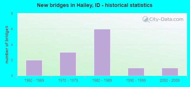
- New bridges - historical statistics
- 21960-1969
- 31970-1979
- 61980-1989
- 11990-1999
- 12000-2009


- Bridge Condition - Deck
- 7.7%Very good
- 53.8%Good
- 23.1%Satisfactory
- 15.4%Fair

- Bridge Condition - Superstructure
- 7.7%Very good
- 69.2%Good
- 23.1%Satisfactory

- Bridge Condition - Substructure
- 7.7%Very good
- 23.1%Good
- 38.5%Satisfactory
- 30.8%Fair

- Bridge Condition - Channel
- 30.8%Very good
- 46.2%Good
- 23.1%Satisfactory
Find on map >> Show street view
Structure Number: 1189, Location: 4.6 N. HAMER (Lat: 43.990500, Lng: -112.230878), Route carried "on" structure: Interstate 15, Year Built: 1989, Status: Open, Structure Length: 0.91m (2.99ft), Average Daily Traffic: 1,700 (year 2019), Truck Traffic: 32%, Average Future Daily Traffic: 2,550 (year 2039), Design Load: HS 25 or greater, Features Intersected: CAMAS CREEK
Minimum Vertical Clearance: 30+ m (98+ ft), Kilometerpoint: 248.132, Lanes on structure: 2, Base Highway Network: Yes, Owner: State Highway Agency, Approaching Roadway Width: 12.2m (40.0ft), Material/Design: Concrete, Design/Construction: Frame, Number Of Spans In Main Unit: 1, Length of Maximum Span: 9.1m (29.9ft), Curb-To-Curb Width: 12.4m (40.7ft), Out-to-Out Width: 13.3m (43.6ft)
Condition: Deck: Good, Superstructure: Good, Substructure: Good, Channel: Very good, Operating Rating: 90.6 metric tons, Method Used To Determine Operating Rating: Load Factor (LF), Inventory Rating: 71.7 metric tons, Method Used To Determine Inventory Rating: Load Factor (LF), Structural Evaluation: Better than present minimum criteria, Deck Geometry: Better than present minimum criteria, Waterway Adequacy: Superior to present desirable criteria, Approach Roadway Alignment: Equal to present desirable criteria, Designated Inspection Frequency: Every 48 months, Inspection Date: November 2021, Deck Structure Type: Concrete Cast-file-Place, Wearing Surface/Protective System: Wearing Surface: Bituminous, Membrane: Preformed Fabric, Deck Protection: Epoxy Coated Reinforcing
Find on map >> Show street view
Structure Number: 1886, Location: 12.3 S. ST MARIES (Lat: 47.175300, Lng: -116.494200), Route carried "on" structure: State highway 3, Year Built: 1961, Year Reconstructed: 2013, Status: Open, Structure Length: 5.09m (16.70ft), Average Daily Traffic: 2,200 (year 2019), Truck Traffic: 14%, Average Future Daily Traffic: 3,300 (year 2039), Design Load: HS 20, Features Intersected: ST MARIES R(MASHBURN BR)
Minimum Vertical Clearance: 30+ m (98+ ft), Kilometerpoint: 115.952, Lanes on structure: 2, Base Highway Network: Yes (Inventory Route: SH0, Subroute: 2), Owner: State Highway Agency, Approaching Roadway Width: 8.8m (28.9ft), Skew: 1 degrees, Material/Design: Prestressed concrete, Design/Construction: Stringer/Multi-beam, Number Of Spans In Main Unit: 1, Number Of Approach Spans: 2, Length of Maximum Span: 26.2m (86.0ft), Curb-To-Curb Width: 9.1m (29.9ft), Out-to-Out Width: 10.0m (32.8ft)
Condition: Deck: Good, Superstructure: Good, Substructure: Satisfactory, Channel: Very good, Operating Rating: 64.4 metric tons, Method Used To Determine Operating Rating: Load Factor (LF), Inventory Rating: 30.8 metric tons, Method Used To Determine Inventory Rating: Load Factor (LF), Structural Evaluation: Equal to present minimum criteria, Deck Geometry: Meets minimum limits, Waterway Adequacy: Superior to present desirable criteria, Approach Roadway Alignment: Equal to present desirable criteria, Length Of Structure Improvement: 6.10m (20.01ft), Designated Inspection Frequency: Every 24 months, Inspection Date: October 2020, Bridge Improvement Cost: $1,452,000, Roadway Improvement Cost: $145,000, Total Project Cost: $2,178,000 ( Estimate for 2020), Deck Structure Type: Concrete Cast-file-Place, Wearing Surface/Protective System: Wearing Surface: Epoxy Overlay, Deck Protection: Epoxy Coated Reinforcing
Find on map >> Show street view
Structure Number: 19275, Location: 2.1 W. SHELLEY (Lat: 43.376722, Lng: -112.169528), Route carried "on" structure: County highway 1847, Year Built: 1965, Status: Open, Structure Length: 12.68m (41.60ft), Average Daily Traffic: 2,800 (year 2019), Truck Traffic: 11%, Average Future Daily Traffic: 4,200 (year 2039), Design Load: HS 20, Features Intersected: SNAKE RIVER;W.SHELLEY BR
Minimum Vertical Clearance: 30+ m (98+ ft), Kilometerpoint: 1.875, Lanes on structure: 2, Owner: County Highway Agency, Approaching Roadway Width: 8.5m (27.9ft), Skew: 2 degrees, Material/Design: Prestressed concrete, Design/Construction: Stringer/Multi-beam, Number Of Spans In Main Unit: 4, Length of Maximum Span: 31.1m (102.0ft), Curb or Sidewalk Widths: Left: 0.5m (1.6ft), Right: 0.5m (1.6ft), Curb-To-Curb Width: 8.5m (27.9ft), Out-to-Out Width: 10.1m (33.1ft)
Condition: Deck: Fair, Superstructure: Satisfactory, Substructure: Satisfactory, Channel: Good, Operating Rating: 43.5 metric tons, Method Used To Determine Operating Rating: Load Factor (LF), Inventory Rating: 20.9 metric tons, Method Used To Determine Inventory Rating: Load Factor (LF), Structural Evaluation: Somewhat better than minimum adequacy, Deck Geometry: Meets minimum limits, Waterway Adequacy: Equal to present desirable criteria, Approach Roadway Alignment: Equal to present desirable criteria, Length Of Structure Improvement: 13.62m (44.69ft), Designated Inspection Frequency: Every 24 months, Underwater Inspection Frequency: Every 60 months, Inspection Date: October 2020, Underwater Inspection Date: October 2020, Bridge Improvement Cost: $3,245,000, Roadway Improvement Cost: $325,000, Total Project Cost: $4,868,000 ( Estimate for 2020), Deck Structure Type: Concrete Cast-file-Place, Wearing Surface/Protective System: Wearing Surface: Monolithic Concrete
Find on map >> Show street view
Structure Number: 19565, Location: 0.3 S. 0.4 W. HAILEY (Lat: 43.516861, Lng: -114.321778), Route carried "on" structure: County highway 2816, Year Built: 1972, Status: Open, Structure Length: 3.08m (10.10ft), Average Daily Traffic: 150 (year 2019), Truck Traffic: 7%, Average Future Daily Traffic: 225 (year 2039), Design Load: HS 20, Features Intersected: BIG WOOD RIVER
Minimum Vertical Clearance: 30+ m (98+ ft), Kilometerpoint: 6.830, Lanes on structure: 2, Owner: County Highway Agency, Approaching Roadway Width: 8.5m (27.9ft), Material/Design: Prestressed concrete, Design/Construction: Stringer/Multi-beam, Number Of Spans In Main Unit: 1, Length of Maximum Span: 30.2m (99.1ft), Curb-To-Curb Width: 8.7m (28.5ft), Out-to-Out Width: 9.7m (31.8ft)
Condition: Deck: Good, Superstructure: Good, Substructure: Good, Channel: Satisfactory, Operating Rating: 77.1 metric tons, Method Used To Determine Operating Rating: Load Factor (LF), Inventory Rating: 47.2 metric tons, Method Used To Determine Inventory Rating: Load Factor (LF), Structural Evaluation: Better than present minimum criteria, Deck Geometry: Equal to present minimum criteria, Waterway Adequacy: Equal to present minimum criteria, Approach Roadway Alignment: Equal to present desirable criteria, Length Of Structure Improvement: 3.96m (12.99ft), Designated Inspection Frequency: Every 48 months, Inspection Date: September 2020, Bridge Improvement Cost: $690,000, Roadway Improvement Cost: $69,000, Total Project Cost: $1,035,000 ( Estimate for 2020), Deck Structure Type: Concrete Cast-file-Place, Wearing Surface/Protective System: Wearing Surface: Bituminous
Find on map >> Show street view
Structure Number: 1957, Location: 6.0 N. 1.6 W. HAILEY (Lat: 43.604917, Lng: -114.346722), Route carried "on" structure: County highway 2818, Year Built: 1974, Status: Open, Structure Length: 3.08m (10.10ft), Average Daily Traffic: 1,600 (year 2019), Truck Traffic: 6%, Average Future Daily Traffic: 2,400 (year 2039), Design Load: HS 20, Features Intersected: BIG WOOD RIVER
Minimum Vertical Clearance: 30+ m (98+ ft), Kilometerpoint: 0.377, Lanes on structure: 2, Owner: County Highway Agency, Approaching Roadway Width: 8.5m (27.9ft), Material/Design: Prestressed concrete, Design/Construction: Stringer/Multi-beam, Number Of Spans In Main Unit: 1, Length of Maximum Span: 29.9m (98.1ft), Curb-To-Curb Width: 8.7m (28.5ft), Out-to-Out Width: 9.7m (31.8ft)
Condition: Deck: Satisfactory, Superstructure: Good, Substructure: Fair, Channel: Very good, Operating Rating: 60.8 metric tons, Method Used To Determine Operating Rating: Load Factor (LF), Inventory Rating: 21.8 metric tons, Method Used To Determine Inventory Rating: Load Factor (LF), Structural Evaluation: Somewhat better than minimum adequacy, Deck Geometry: Somewhat better than minimum adequacy, Waterway Adequacy: Better than present minimum criteria, Approach Roadway Alignment: Better than present minimum criteria, Length Of Structure Improvement: 3.87m (12.70ft), Designated Inspection Frequency: Every 24 months, Inspection Date: September 2020, Bridge Improvement Cost: $880,000, Roadway Improvement Cost: $88,000, Total Project Cost: $1,320,000 ( Estimate for 2018), Deck Structure Type: Concrete Cast-file-Place, Wearing Surface/Protective System: Wearing Surface: Bituminous
Find on map >> Show street view
Structure Number: 19816, Location: 1.5S. 2.8E MERIDIAN (Lat: 43.589931, Lng: -116.334350), Route carried "on" structure: County highway 7013, Year Built: 2005, Status: Open, Structure Length: 0.91m (2.99ft), Average Daily Traffic: 12,000 (year 2019), Truck Traffic: 3%, Average Future Daily Traffic: 18,000 (year 2039), Design Load: HS 25 or greater, Features Intersected: RIDENBAUGH CANAL
Minimum Vertical Clearance: 30+ m (98+ ft), Kilometerpoint: 11.259, Lanes on structure: 5, Owner: County Highway Agency, Approaching Roadway Width: 21.3m (69.9ft), Material/Design: Concrete, Design/Construction: Frame, Number Of Spans In Main Unit: 1, Length of Maximum Span: 9.1m (29.9ft), Curb or Sidewalk Widths: Left: 2.3m (7.5ft), Right: 2.3m (7.5ft), Curb-To-Curb Width: 21.4m (70.2ft), Out-to-Out Width: 26.4m (86.6ft)
Condition: Deck: Good, Superstructure: Good, Substructure: Good, Channel: Good, Structural Evaluation: Better than present minimum criteria, Deck Geometry: Somewhat better than minimum adequacy, Waterway Adequacy: Superior to present desirable criteria, Approach Roadway Alignment: Equal to present desirable criteria, Designated Inspection Frequency: Every 48 months, Inspection Date: Febuary 2020, Deck Structure Type: Concrete Cast-file-Place, Wearing Surface/Protective System: Wearing Surface: Monolithic Concrete, Deck Protection: Epoxy Coated Reinforcing
Find on map >> Show street view
Structure Number: 2044, Location: POST FALLS SCL (Lat: 47.705717, Lng: -116.948294), Route carried "on" structure: County highway 7505, Year Built: 1971, Status: Open, Structure Length: 27.43m (89.99ft), Average Daily Traffic: 5,800 (year 2019), Truck Traffic: 5%, Average Future Daily Traffic: 8,700 (year 2039), Design Load: HS 20, Features Intersected: SPOKANE R.;POST FALLS BR
Minimum Vertical Clearance: 30+ m (98+ ft), Kilometerpoint: 1.051, Lanes on structure: 2, Owner: Local Agency, Approaching Roadway Width: 10.4m (34.1ft), Navigation Control: Yes ( Vertical Clearance: 2.0m (6.6ft), Horizontal Clearance: 35.0m (114.8ft)), Material/Design: Prestressed concrete, Design/Construction: Stringer/Multi-beam, Number Of Spans In Main Unit: 14, Length of Maximum Span: 36.3m (119.1ft), Curb or Sidewalk Widths: Left: 0.0m, Right: 1.6m (5.2ft), Curb-To-Curb Width: 10.6m (34.8ft), Out-to-Out Width: 13.4m (44.0ft)
Condition: Deck: Fair, Superstructure: Good, Substructure: Fair, Channel: Satisfactory, Operating Rating: 54.4 metric tons, Method Used To Determine Operating Rating: Load Factor (LF), Inventory Rating: 32.7 metric tons, Method Used To Determine Inventory Rating: Load Factor (LF), Structural Evaluation: Somewhat better than minimum adequacy, Deck Geometry: Meets minimum limits, Waterway Adequacy: Equal to present minimum criteria, Approach Roadway Alignment: Equal to present desirable criteria, Length Of Structure Improvement: 27.71m (90.91ft), Designated Inspection Frequency: Every 24 months, Underwater Inspection Frequency: Every 60 months, Inspection Date: August 2020, Underwater Inspection Date: October 2021, Bridge Improvement Cost: $9,300,000, Roadway Improvement Cost: $930,000, Total Project Cost: $13,950,000 ( Estimate for 2018), Deck Structure Type: Concrete Cast-file-Place, Wearing Surface/Protective System: Wearing Surface: Monolithic Concrete
Find on map >> Show street view
Structure Number: 23703, Location: IN BELLEVUE (Lat: 43.454972, Lng: -114.258917), Route carried "on" structure: City street , Year Built: 1980, Status: Open, Structure Length: 0.76m (2.49ft), Average Daily Traffic: 40 (year 2020), Average Future Daily Traffic: 60 (year 2040), Design Load: HS 20, Features Intersected: BELLEVUE CANAL, Facility Carried by Structure: RIVERVIEW STREET
Minimum Vertical Clearance: 30+ m (98+ ft), Kilometerpoint: 0.964, Lanes on structure: 2, Owner: City or Municipal Highway Agency, Approaching Roadway Width: 8.5m (27.9ft), Material/Design: Prestressed concrete, Design/Construction: Stringer/Multi-beam, Number Of Spans In Main Unit: 1, Length of Maximum Span: 7.0m (23.0ft), Curb or Sidewalk Widths: Left: 0.2m (0.7ft), Right: 0.2m (0.7ft), Curb-To-Curb Width: 9.3m (30.5ft), Out-to-Out Width: 9.8m (32.2ft)
Condition: Deck: Satisfactory, Superstructure: Satisfactory, Substructure: Fair, Channel: Good, Operating Rating: 34.5 metric tons, Method Used To Determine Operating Rating: Field evaluation and documented engineering judgment, Inventory Rating: 20.9 metric tons, Method Used To Determine Inventory Rating: Field evaluation and documented engineering judgment, Structural Evaluation: Somewhat better than minimum adequacy, Deck Geometry: Better than present minimum criteria, Waterway Adequacy: Equal to present desirable criteria, Approach Roadway Alignment: Equal to present desirable criteria, Length Of Structure Improvement: 1.37m (4.49ft), Designated Inspection Frequency: Every 24 months, Inspection Date: November 2020, Bridge Improvement Cost: $312,000, Roadway Improvement Cost: $31,000, Total Project Cost: $468,000 ( Estimate for 2020), Deck Structure Type: Concrete Precast Panels, Wearing Surface/Protective System: Wearing Surface: Monolithic Concrete
Find on map >> Show street view
Structure Number: 23715, Location: 2.0 N. 1.0 W. HAILEY (Lat: 43.556889, Lng: -114.342778), Route carried "on" structure: County highway , Year Built: 1982, Status: Open, Structure Length: 3.47m (11.38ft), Average Daily Traffic: 30 (year 2019), Truck Traffic: 33%, Average Future Daily Traffic: 45 (year 2039), Design Load: HS 20, Features Intersected: BIG WOOD RIVER;DEER CR., Facility Carried by Structure: DEER CREEK ROAD
Minimum Vertical Clearance: 30+ m (98+ ft), Kilometerpoint: 177.607, Lanes on structure: 2, Owner: County Highway Agency, Approaching Roadway Width: 8.5m (27.9ft), Skew: 2 degrees, Material/Design: Prestressed concrete, Design/Construction: Stringer/Multi-beam, Number Of Spans In Main Unit: 1, Length of Maximum Span: 34.4m (112.9ft), Curb-To-Curb Width: 9.5m (31.2ft), Out-to-Out Width: 10.3m (33.8ft)
Condition: Deck: Very good, Superstructure: Good, Substructure: Fair, Channel: Satisfactory, Operating Rating: 56.2 metric tons, Method Used To Determine Operating Rating: Load Factor (LF), Inventory Rating: 29.9 metric tons, Method Used To Determine Inventory Rating: Load Factor (LF), Structural Evaluation: Somewhat better than minimum adequacy, Deck Geometry: Better than present minimum criteria, Waterway Adequacy: Equal to present desirable criteria, Approach Roadway Alignment: Better than present minimum criteria, Designated Inspection Frequency: Every 24 months, Inspection Date: September 2020, Deck Structure Type: Concrete Cast-file-Place, Wearing Surface/Protective System: Wearing Surface: Bituminous
Find on map >> Show street view
Structure Number: 2375, Location: 1.8 N. 1.7 W. BELLEVUE (Lat: 43.491333, Lng: -114.295278), Route carried "on" structure: County highway , Year Built: 1985, Status: Open, Structure Length: 3.14m (10.30ft), Average Daily Traffic: 640 (year 2019), Truck Traffic: 17%, Average Future Daily Traffic: 960 (year 2039), Design Load: HS 20, Features Intersected: BIG WOOD RIVER, Facility Carried by Structure: BROADFORD ROAD
Minimum Vertical Clearance: 30+ m (98+ ft), Kilometerpoint: 165.993, Lanes on structure: 2, Owner: County Highway Agency, Approaching Roadway Width: 8.5m (27.9ft), Skew: 1 degrees, Material/Design: Prestressed concrete, Design/Construction: Stringer/Multi-beam, Number Of Spans In Main Unit: 1, Length of Maximum Span: 30.5m (100.1ft), Curb-To-Curb Width: 9.4m (30.8ft), Out-to-Out Width: 10.3m (33.8ft)
Condition: Deck: Good, Superstructure: Very good, Substructure: Very good, Channel: Good, Operating Rating: 59.0 metric tons, Method Used To Determine Operating Rating: Load Factor (LF), Inventory Rating: 30.8 metric tons, Method Used To Determine Inventory Rating: Load Factor (LF), Structural Evaluation: Better than present minimum criteria, Deck Geometry: Equal to present minimum criteria, Waterway Adequacy: Equal to present desirable criteria, Approach Roadway Alignment: Equal to present minimum criteria, Designated Inspection Frequency: Every 24 months, Inspection Date: September 2019, Deck Structure Type: Concrete Cast-file-Place, Wearing Surface/Protective System: Wearing Surface: Bituminous
Find on map >> Show street view
Structure Number: 2736, Location: 3.2 S. 0.7 W. PARMA (Lat: 43.742000, Lng: -116.962000), Route carried "on" structure: County highway , Year Built: 1983, Status: Open, Structure Length: 0.91m (2.99ft), Average Daily Traffic: 200 (year 2019), Truck Traffic: 10%, Average Future Daily Traffic: 300 (year 2039), Design Load: HS 20, Features Intersected: RIVERSIDE CANAL, Facility Carried by Structure: STEPHEN LANE
Minimum Vertical Clearance: 30+ m (98+ ft), Kilometerpoint: 165.893, Lanes on structure: 2, Owner: Local Agency, Approaching Roadway Width: 6.7m (22.0ft), Material/Design: Prestressed concrete, Design/Construction: Tee Beam, Number Of Spans In Main Unit: 1, Length of Maximum Span: 8.8m (28.9ft), Curb or Sidewalk Widths: Left: 0.3m (1.0ft), Right: 0.3m (1.0ft), Curb-To-Curb Width: 9.1m (29.9ft), Out-to-Out Width: 9.8m (32.2ft)
Condition: Deck: Good, Superstructure: Satisfactory, Substructure: Satisfactory, Channel: Good, Operating Rating: 41.7 metric tons, Method Used To Determine Operating Rating: Load Factor (LF), Inventory Rating: 21.8 metric tons, Method Used To Determine Inventory Rating: Load Factor (LF), Structural Evaluation: Equal to present minimum criteria, Deck Geometry: Equal to present minimum criteria, Waterway Adequacy: Better than present minimum criteria, Approach Roadway Alignment: Somewhat better than minimum adequacy, Designated Inspection Frequency: Every 24 months, Inspection Date: Febuary 2020, Deck Structure Type: Concrete Cast-file-Place, Wearing Surface/Protective System: Wearing Surface: Bituminous
Find on map >> Show street view
Structure Number: 29436, Location: 1.5 S. 0.3 E. PRINCETON (Lat: 46.892089, Lng: -116.828608), Route carried "on" structure: County highway , Year Built: 1991, Status: Open, Structure Length: 1.37m (4.49ft), Average Daily Traffic: 30 (year 2019), Truck Traffic: 10%, Average Future Daily Traffic: 45 (year 2039), Design Load: HS 20, Features Intersected: HATTER CREEK, Facility Carried by Structure: QUAIL ROAD
Minimum Vertical Clearance: 30+ m (98+ ft), Kilometerpoint: 160.949, Lanes on structure: 2, Owner: Local Agency, Approaching Roadway Width: 7.9m (25.9ft), Material/Design: Prestressed concrete, Design/Construction: Tee Beam, Number Of Spans In Main Unit: 1, Length of Maximum Span: 13.1m (43.0ft), Curb-To-Curb Width: 8.0m (26.2ft), Out-to-Out Width: 9.8m (32.2ft)
Condition: Deck: Good, Superstructure: Good, Substructure: Satisfactory, Channel: Very good, Operating Rating: 61.7 metric tons, Method Used To Determine Operating Rating: Allowable Stress (AS), Inventory Rating: 39.6 metric tons, Method Used To Determine Inventory Rating: Allowable Stress (AS), Structural Evaluation: Equal to present minimum criteria, Deck Geometry: Equal to present minimum criteria, Waterway Adequacy: Superior to present desirable criteria, Approach Roadway Alignment: Equal to present minimum criteria, Designated Inspection Frequency: Every 24 months, Inspection Date: June 2020, Deck Structure Type: Concrete Precast Panels, Wearing Surface/Protective System: Wearing Surface: Bituminous
Find on map >> Show street view
Structure Number: 2944, Location: 3.6 S. 0.6 E. PRINCETON (Lat: 46.861250, Lng: -116.822833), Route carried "on" structure: County highway , Year Built: 1984, Status: Open, Structure Length: 0.85m (2.79ft), Average Daily Traffic: 30 (year 2019), Truck Traffic: 33%, Average Future Daily Traffic: 45 (year 2039), Design Load: HS 20, Features Intersected: HATTER CREEK, Facility Carried by Structure: E. HATTER CR. ROAD
Minimum Vertical Clearance: 30+ m (98+ ft), Kilometerpoint: 160.937, Lanes on structure: 2, Owner: Local Agency, Approaching Roadway Width: 6.1m (20.0ft), Skew: 2 degrees, Material/Design: Steel, Design/Construction: Stringer/Multi-beam, Number Of Spans In Main Unit: 1, Length of Maximum Span: 8.2m (26.9ft), Curb-To-Curb Width: 7.2m (23.6ft), Out-to-Out Width: 7.3m (24.0ft)
Condition: Deck: Satisfactory, Superstructure: Good, Substructure: Satisfactory, Channel: Good, Operating Rating: 54.4 metric tons, Method Used To Determine Operating Rating: Load Factor (LF), Inventory Rating: 32.7 metric tons, Method Used To Determine Inventory Rating: Load Factor (LF), Structural Evaluation: Equal to present minimum criteria, Deck Geometry: Somewhat better than minimum adequacy, Waterway Adequacy: Better than present minimum criteria, Approach Roadway Alignment: Better than present minimum criteria, Designated Inspection Frequency: Every 24 months, Inspection Date: June 2020, Deck Structure Type: Corrugated Steel, Wearing Surface/Protective System: Wearing Surface: Bituminous