Bridge Statistics for Holtsville, New York (NY)
Condition, Traffic, Stress, Structural Evaluation, Project Costs
- National Bridge Inventory (NBI) Statistics
- 31Number of bridges
- 285ft / 86.8mTotal length
- $101,832,000Total costs
- 1,056,707Total average daily traffic
- 35,670Total average daily truck traffic
- National Bridge Inventory (NBI) Registered Bridges for Holtsville
- No street view available for this location
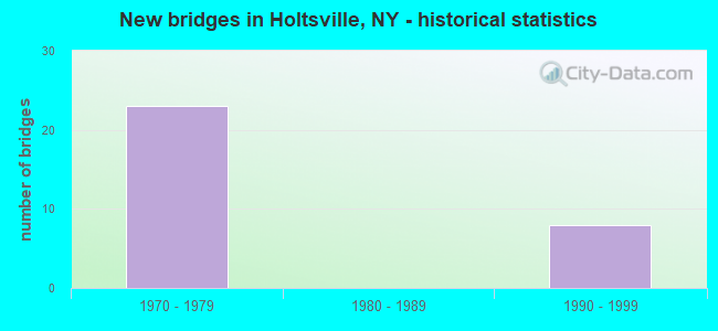
- New bridges - historical statistics
- 231970-1979
- 81990-1999
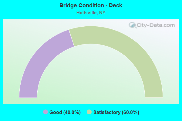
- Bridge Condition - Deck
- 40.0%Good
- 60.0%Satisfactory
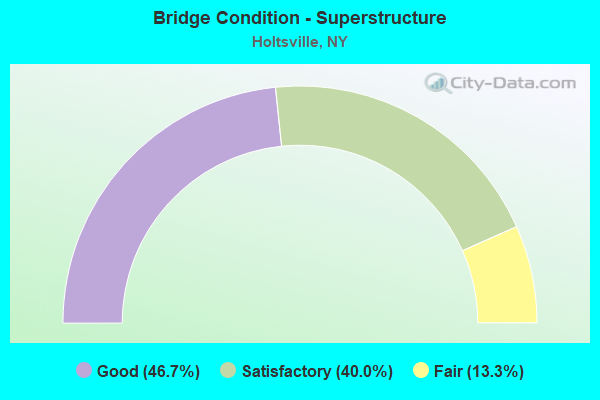
- Bridge Condition - Superstructure
- 46.7%Good
- 40.0%Satisfactory
- 13.3%Fair
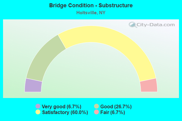
- Bridge Condition - Substructure
- 6.7%Very good
- 26.7%Good
- 60.0%Satisfactory
- 6.7%Fair
Find on map >> Show street view
Structure Number: 1064061, Location: 4.3 MI W JT RTS 495I &112 (Lat: 40.816353, Lng: -73.079056), Route carried "on" structure: Interstate 495, Year Built: 1998, Status: Open, Structure Length: 2.96m (9.71ft), Average Daily Traffic: 76,575 (year 2005), Truck Traffic: 13%, Design Load: HS 25 or greater, Features Intersected: HOLBROOK ROAD
Minimum Vertical Clearance: 30+ m (98+ ft), Kilometerpoint: 31.440, Lanes on structure: 4, Lanes under structure: 4, Base Highway Network: Yes, Owner: State Highway Agency, Approaching Roadway Width: 22.9m (75.1ft), Material/Design: Prestressed concrete, Design/Construction: Box Beam or Girders - Multiple, Number Of Spans In Main Unit: 1, Length of Maximum Span: 28.3m (92.8ft), Curb-To-Curb Width: 23.0m (75.5ft), Out-to-Out Width: 24.0m (78.7ft)
Condition: Deck: Good, Superstructure: Good, Substructure: Very good, Operating Rating: 89.8 metric tons, Method Used To Determine Operating Rating: Load Factor (LF), Inventory Rating: 40.8 metric tons, Method Used To Determine Inventory Rating: Load Factor (LF), Structural Evaluation: Better than present minimum criteria, Deck Geometry: Superior to present desirable criteria, Underclear: High priority of corrective action, Approach Roadway Alignment: Equal to present desirable criteria, Length Of Structure Improvement: 2.95m (9.68ft), Designated Inspection Frequency: Every 24 months, Inspection Date: September 2021, Bridge Improvement Cost: $3,301,000, Roadway Improvement Cost: $1,933,000, Total Project Cost: $5,234,000 ( Estimate for 2021), Deck Structure Type: Concrete Cast-file-Place, Wearing Surface/Protective System: Wearing Surface: Monolithic Concrete
Find on map >> Show street view
Structure Number: 1064062, Location: 4.3 MI W JT RTS 495I &112 (Lat: 40.816089, Lng: -73.079008), Route carried "on" structure: Interstate 495, Year Built: 1998, Status: Open, Structure Length: 2.96m (9.71ft), Average Daily Traffic: 70,297 (year 2018), Truck Traffic: 6%, Average Future Daily Traffic: 73,812 (year 2040), Design Load: HS 25 or greater, Features Intersected: HOLBROOK ROAD
Minimum Vertical Clearance: 30+ m (98+ ft), Kilometerpoint: 31.440, Lanes on structure: 5, Lanes under structure: 4, Base Highway Network: Yes, Owner: State Highway Agency, Approaching Roadway Width: 26.5m (86.9ft), Material/Design: Prestressed concrete, Design/Construction: Box Beam or Girders - Multiple, Number Of Spans In Main Unit: 1, Length of Maximum Span: 28.3m (92.8ft), Curb-To-Curb Width: 26.6m (87.3ft), Out-to-Out Width: 27.7m (90.9ft)
Condition: Deck: Good, Superstructure: Good, Substructure: Good, Operating Rating: 89.8 metric tons, Method Used To Determine Operating Rating: Load Factor (LF), Inventory Rating: 40.8 metric tons, Method Used To Determine Inventory Rating: Load Factor (LF), Structural Evaluation: Better than present minimum criteria, Deck Geometry: Superior to present desirable criteria, Underclear: High priority of corrective action, Approach Roadway Alignment: Equal to present desirable criteria, Length Of Structure Improvement: 2.95m (9.68ft), Designated Inspection Frequency: Every 24 months, Inspection Date: September 2021, Bridge Improvement Cost: $3,812,000, Roadway Improvement Cost: $2,232,000, Total Project Cost: $6,044,000 ( Estimate for 2021), Deck Structure Type: Concrete Cast-file-Place, Wearing Surface/Protective System: Wearing Surface: Integral Concrete
Find on map >> Show street view
Structure Number: 1064071, Location: 3 MI W JCT RTS I495 & 112 (Lat: 40.820250, Lng: -73.054089), Route carried "on" structure: Interstate 495, Year Built: 1998, Status: Open, Structure Length: 5.79m (19.00ft), Average Daily Traffic: 64,370 (year 2007), Truck Traffic: 13%, Design Load: HS 25 or greater, Features Intersected: CR 97-NICOLLS RD, SB, CR
Minimum Vertical Clearance: 30+ m (98+ ft), Kilometerpoint: 33.564, Lanes on structure: 4, Lanes under structure: 6, Base Highway Network: Yes, Owner: State Highway Agency, Approaching Roadway Width: 22.9m (75.1ft), Material/Design: Steel continuous, Design/Construction: Stringer/Multi-beam, Number Of Spans In Main Unit: 2, Length of Maximum Span: 28.3m (92.8ft), Curb-To-Curb Width: 23.0m (75.5ft), Out-to-Out Width: 23.9m (78.4ft)
Condition: Deck: Good, Superstructure: Good, Substructure: Good, Operating Rating: 89.8 metric tons, Method Used To Determine Operating Rating: Load Factor (LF), Inventory Rating: 54.4 metric tons, Method Used To Determine Inventory Rating: Load Factor (LF), Structural Evaluation: Better than present minimum criteria, Deck Geometry: Superior to present desirable criteria, Underclear: Meets minimum limits, Approach Roadway Alignment: Equal to present desirable criteria, Length Of Structure Improvement: 5.79m (19.00ft), Designated Inspection Frequency: Every 24 months, Inspection Date: June 2021, Bridge Improvement Cost: $5,866,000, Roadway Improvement Cost: $3,435,000, Total Project Cost: $9,301,000 ( Estimate for 2021), Deck Structure Type: Concrete Cast-file-Place, Wearing Surface/Protective System: Wearing Surface: Integral Concrete, Deck Protection: Epoxy Coated Reinforcing
Find on map >> Show street view
Structure Number: 1064072, Location: 3 MI W JCT RTS I495 & 112 (Lat: 40.819933, Lng: -73.054333), Route carried "on" structure: Interstate 495, Year Built: 1998, Status: Open, Structure Length: 5.79m (19.00ft), Average Daily Traffic: 63,545 (year 2019), Truck Traffic: 5%, Average Future Daily Traffic: 66,721 (year 2040), Design Load: HS 25 or greater, Features Intersected: CR 97-NICOLLS RD, SB, CR
Minimum Vertical Clearance: 30+ m (98+ ft), Kilometerpoint: 33.564, Lanes on structure: 4, Lanes under structure: 6, Base Highway Network: Yes, Owner: State Highway Agency, Approaching Roadway Width: 22.9m (75.1ft), Material/Design: Steel continuous, Design/Construction: Stringer/Multi-beam, Number Of Spans In Main Unit: 2, Length of Maximum Span: 28.3m (92.8ft), Curb-To-Curb Width: 23.0m (75.5ft), Out-to-Out Width: 24.0m (78.7ft)
Condition: Deck: Satisfactory, Superstructure: Good, Substructure: Good, Operating Rating: 89.8 metric tons, Method Used To Determine Operating Rating: Load Factor (LF), Inventory Rating: 54.4 metric tons, Method Used To Determine Inventory Rating: Load Factor (LF), Structural Evaluation: Better than present minimum criteria, Deck Geometry: Superior to present desirable criteria, Underclear: Meets minimum limits, Approach Roadway Alignment: Equal to present desirable criteria, Length Of Structure Improvement: 5.79m (19.00ft), Designated Inspection Frequency: Every 24 months, Inspection Date: June 2021, Bridge Improvement Cost: $5,874,000, Roadway Improvement Cost: $3,440,000, Total Project Cost: $9,313,000 ( Estimate for 2021), Deck Structure Type: Concrete Cast-file-Place, Wearing Surface/Protective System: Wearing Surface: Integral Concrete, Deck Protection: Epoxy Coated Reinforcing
Find on map >> Show street view
Structure Number: 106408, Location: 2.6 MI W JCT I495 & SH112 (Lat: 40.821186, Lng: -73.045794), Route carried "on" structure: Other road , Year Built: 1970, Year Reconstructed: 2013, Status: Open, Structure Length: 7.32m (24.02ft), Average Daily Traffic: 4,425 (year 2018), Truck Traffic: 5%, Average Future Daily Traffic: 5,375 (year 2040), Design Load: H 20, Features Intersected: 495I495I07041213, RTE I4, Facility Carried by Structure: WAVERLY AVENUE
Minimum Vertical Clearance: 30+ m (98+ ft), Kilometerpoint: 3.475, Lanes on structure: 2, Lanes under structure: 9, Owner: State Highway Agency, Approaching Roadway Width: 8.5m (27.9ft), Material/Design: Steel, Design/Construction: Stringer/Multi-beam, Number Of Spans In Main Unit: 4, Length of Maximum Span: 25.9m (85.0ft), Curb or Sidewalk Widths: Left: 1.7m (5.6ft), Right: 1.7m (5.6ft), Curb-To-Curb Width: 8.4m (27.6ft), Out-to-Out Width: 13.0m (42.7ft)
Condition: Deck: Good, Superstructure: Satisfactory, Substructure: Satisfactory, Operating Rating: 88.9 metric tons, Method Used To Determine Operating Rating: Load Factor (LF), Inventory Rating: 53.5 metric tons, Method Used To Determine Inventory Rating: Load Factor (LF), Structural Evaluation: Equal to present minimum criteria, Deck Geometry: High priority of corrective action, Underclear: High priority of corrective action, Approach Roadway Alignment: Better than present minimum criteria, Length Of Structure Improvement: 7.31m (23.98ft), Designated Inspection Frequency: Every 24 months, Inspection Date: Febuary 2020, Bridge Improvement Cost: $3,524,000, Roadway Improvement Cost: $2,063,000, Total Project Cost: $5,587,000 ( Estimate for 2021), Deck Structure Type: Concrete Cast-file-Place, Wearing Surface/Protective System: Wearing Surface: Integral Concrete
Find on map >> Show street view
Structure Number: 106456, Location: 3 MI W JCT RTS 495+112 (Lat: 40.819806, Lng: -73.054039), Route carried "on" structure: ServiceState highway 906A, Year Built: 1970, Status: Open, Structure Length: 6.37m (20.90ft), Average Daily Traffic: 20,514 (year 2020), Truck Traffic: 6%, Average Future Daily Traffic: 23,669 (year 2040), Design Load: H 20, Features Intersected: CR 97-NICOLLS RD, SB, CR
Minimum Vertical Clearance: 30+ m (98+ ft), Kilometerpoint: 33.757, Lanes on structure: 3, Lanes under structure: 6, Base Highway Network: Yes, Owner: State Highway Agency, Approaching Roadway Width: 11.6m (38.1ft), Material/Design: Steel, Design/Construction: Stringer/Multi-beam, Number Of Spans In Main Unit: 4, Length of Maximum Span: 21.9m (71.9ft), Curb or Sidewalk Widths: Left: 0.5m (1.6ft), Right: 0.5m (1.6ft), Curb-To-Curb Width: 11.6m (38.1ft), Out-to-Out Width: 13.2m (43.3ft)
Condition: Deck: Good, Superstructure: Satisfactory, Substructure: Satisfactory, Operating Rating: 75.3 metric tons, Method Used To Determine Operating Rating: Load Factor (LF), Inventory Rating: 45.4 metric tons, Method Used To Determine Inventory Rating: Load Factor (LF), Structural Evaluation: Equal to present minimum criteria, Deck Geometry: High priority of replacement, Underclear: High priority of corrective action, Approach Roadway Alignment: Better than present minimum criteria, Length Of Structure Improvement: 6.37m (20.90ft), Designated Inspection Frequency: Every 24 months, Inspection Date: June 2021, Bridge Improvement Cost: $3,212,000, Roadway Improvement Cost: $1,881,000, Total Project Cost: $5,093,000 ( Estimate for 2021), Deck Structure Type: Concrete Cast-file-Place, Wearing Surface/Protective System: Wearing Surface: Monolithic Concrete
Find on map >> Show street view
Structure Number: 106457, Location: 3 MI W JCT I495 & SH 112 (Lat: 40.820381, Lng: -73.054383), Route carried "on" structure: Ramp State highway 906B, Year Built: 1970, Status: Open, Structure Length: 6.43m (21.10ft), Average Daily Traffic: 21,947 (year 2020), Truck Traffic: 6%, Average Future Daily Traffic: 25,322 (year 2040), Design Load: H 20, Features Intersected: CR 97-NICOLLS RD, SB, CR
Minimum Vertical Clearance: 30+ m (98+ ft), Kilometerpoint: 9.960, Lanes on structure: 3, Lanes under structure: 6, Base Highway Network: Yes, Owner: State Highway Agency, Approaching Roadway Width: 11.6m (38.1ft), Material/Design: Steel, Design/Construction: Stringer/Multi-beam, Number Of Spans In Main Unit: 4, Length of Maximum Span: 21.9m (71.9ft), Curb or Sidewalk Widths: Left: 0.5m (1.6ft), Right: 0.5m (1.6ft), Curb-To-Curb Width: 11.6m (38.1ft), Out-to-Out Width: 13.2m (43.3ft)
Condition: Deck: Good, Superstructure: Fair, Substructure: Satisfactory, Operating Rating: 60.8 metric tons, Method Used To Determine Operating Rating: Load Factor (LF), Inventory Rating: 36.3 metric tons, Method Used To Determine Inventory Rating: Load Factor (LF), Structural Evaluation: Somewhat better than minimum adequacy, Deck Geometry: High priority of replacement, Underclear: High priority of corrective action, Approach Roadway Alignment: Better than present minimum criteria, Length Of Structure Improvement: 6.43m (21.10ft), Designated Inspection Frequency: Every 24 months, Inspection Date: June 2021, Bridge Improvement Cost: $3,240,000, Roadway Improvement Cost: $1,897,000, Total Project Cost: $5,137,000 ( Estimate for 2021), Deck Structure Type: Concrete Cast-file-Place, Wearing Surface/Protective System: Wearing Surface: Monolithic Concrete
Find on map >> Show street view
Structure Number: 3364381, Location: 1 MI W OF FARMINGVILLE (Lat: 40.835503, Lng: -73.056819), Route carried "on" structure: Other road , Year Built: 1970, Status: Open, Structure Length: 5.24m (17.19ft), Average Daily Traffic: 33,143 (year 2020), Truck Traffic: 4%, Average Future Daily Traffic: 38,240 (year 2040), Design Load: HS 20, Features Intersected: PORTION ROAD EB, PORTION, Facility Carried by Structure: NICOLLS ROAD SB
Minimum Vertical Clearance: 30+ m (98+ ft), Kilometerpoint: 9.525, Lanes on structure: 3, Lanes under structure: 6, Owner: County Highway Agency, Approaching Roadway Width: 12.2m (40.0ft), Material/Design: Steel, Design/Construction: Stringer/Multi-beam, Number Of Spans In Main Unit: 4, Length of Maximum Span: 16.1m (52.8ft), Curb or Sidewalk Widths: Left: 1.5m (4.9ft), Right: 0.5m (1.6ft), Curb-To-Curb Width: 15.2m (49.9ft), Out-to-Out Width: 17.9m (58.7ft)
Condition: Deck: Satisfactory, Superstructure: Good, Substructure: Satisfactory, Operating Rating: 89.8 metric tons, Method Used To Determine Operating Rating: Load Factor (LF), Inventory Rating: 53.5 metric tons, Method Used To Determine Inventory Rating: Load Factor (LF), Structural Evaluation: Equal to present minimum criteria, Deck Geometry: Equal to present minimum criteria, Underclear: High priority of corrective action, Approach Roadway Alignment: Equal to present desirable criteria, Length Of Structure Improvement: 5.24m (17.19ft), Designated Inspection Frequency: Every 24 months, Inspection Date: Febuary 2020, Bridge Improvement Cost: $3,740,000, Roadway Improvement Cost: $2,190,000, Total Project Cost: $5,931,000 ( Estimate for 2021), Deck Structure Type: Concrete Cast-file-Place, Wearing Surface/Protective System: Wearing Surface: Bituminous
Find on map >> Show street view
Structure Number: 3364382, Location: 1 MI W OF FARMINGVILLE (Lat: 40.835550, Lng: -73.056542), Route carried "on" structure: County highway , Year Built: 1970, Status: Open, Structure Length: 5.24m (17.19ft), Average Daily Traffic: 33,143 (year 2020), Truck Traffic: 4%, Average Future Daily Traffic: 38,240 (year 2040), Design Load: HS 20, Features Intersected: PORTION ROAD WB, PORTION, Facility Carried by Structure: NICOLLS ROAD NB
Minimum Vertical Clearance: 30+ m (98+ ft), Kilometerpoint: 9.525, Lanes on structure: 3, Lanes under structure: 6, Owner: County Highway Agency, Approaching Roadway Width: 12.2m (40.0ft), Material/Design: Steel, Design/Construction: Stringer/Multi-beam, Number Of Spans In Main Unit: 4, Length of Maximum Span: 16.1m (52.8ft), Curb or Sidewalk Widths: Left: 0.5m (1.6ft), Right: 1.4m (4.6ft), Curb-To-Curb Width: 15.2m (49.9ft), Out-to-Out Width: 17.9m (58.7ft)
Condition: Deck: Satisfactory, Superstructure: Good, Substructure: Fair, Operating Rating: 79.3 metric tons, Method Used To Determine Operating Rating: Field evaluation and documented engineering judgment, Inventory Rating: 32.7 metric tons, Method Used To Determine Inventory Rating: Field evaluation and documented engineering judgment, Structural Evaluation: Somewhat better than minimum adequacy, Deck Geometry: Equal to present minimum criteria, Underclear: Meets minimum limits, Approach Roadway Alignment: Equal to present desirable criteria, Length Of Structure Improvement: 5.24m (17.19ft), Designated Inspection Frequency: Every 24 months, Inspection Date: Febuary 2020, Bridge Improvement Cost: $3,740,000, Roadway Improvement Cost: $2,190,000, Total Project Cost: $5,931,000 ( Estimate for 2021), Deck Structure Type: Concrete Cast-file-Place, Wearing Surface/Protective System: Wearing Surface: Bituminous
Find on map >> Show street view
Structure Number: 336443, Location: 1 MI SW OF FARMINGVILLE (Lat: 40.826011, Lng: -73.055139), Route carried "on" structure: County highway , Year Built: 1975, Status: Open, Structure Length: 5.18m (16.99ft), Average Daily Traffic: 1,802 (year 2017), Truck Traffic: 6%, Average Future Daily Traffic: 2,523 (year 2037), Design Load: HS 20, Features Intersected: NICOLLS RD. NB, NICOLLS, Facility Carried by Structure: DIVISION ST
Minimum Vertical Clearance: 30+ m (98+ ft), Kilometerpoint: 0.418, Lanes on structure: 2, Lanes under structure: 4, Owner: County Highway Agency, Approaching Roadway Width: 8.5m (27.9ft), Material/Design: Steel, Design/Construction: Stringer/Multi-beam, Number Of Spans In Main Unit: 2, Length of Maximum Span: 25.2m (82.7ft), Curb or Sidewalk Widths: Left: 1.5m (4.9ft), Right: 1.5m (4.9ft), Curb-To-Curb Width: 8.5m (27.9ft), Out-to-Out Width: 12.2m (40.0ft)
Condition: Deck: Satisfactory, Superstructure: Fair, Substructure: Satisfactory, Operating Rating: 34.0 metric tons, Method Used To Determine Operating Rating: Load and Resistance Factor Rating (LRFR) rating reported by rating factor(RF) method using HL-93 loadings, Inventory Rating: 26.2 metric tons, Method Used To Determine Inventory Rating: Load and Resistance Factor Rating (LRFR) rating reported by rating factor(RF) method using HL-93 loadings, Structural Evaluation: Somewhat better than minimum adequacy, Deck Geometry: Somewhat better than minimum adequacy, Underclear: Somewhat better than minimum adequacy, Approach Roadway Alignment: Meets minimum limits, Length Of Structure Improvement: 5.18m (16.99ft), Designated Inspection Frequency: Every 24 months, Inspection Date: March 2020, Bridge Improvement Cost: $2,679,000, Roadway Improvement Cost: $1,569,000, Total Project Cost: $4,247,000 ( Estimate for 2021), Deck Structure Type: Concrete Cast-file-Place, Wearing Surface/Protective System: Wearing Surface: Integral Concrete
Find on map >> Show street view
Structure Number: 3364441, Location: 0.6 MI WEST OF HOLTSVILLE (Lat: 40.812917, Lng: -73.053331), Route carried "on" structure: County highway , Year Built: 1975, Status: Open, Structure Length: 10.30m (33.79ft), Average Daily Traffic: 30,901 (year 2018), Truck Traffic: 6%, Average Future Daily Traffic: 35,653 (year 2040), Design Load: HS 20, Features Intersected: FURROWS RD, LONG ISLAND, Facility Carried by Structure: NICOLLS RD SB
Minimum Vertical Clearance: 30+ m (98+ ft), Kilometerpoint: 6.935, Lanes on structure: 2, Lanes under structure: 6, Owner: County Highway Agency, Approaching Roadway Width: 12.2m (40.0ft), Material/Design: Steel, Design/Construction: Stringer/Multi-beam, Number Of Spans In Main Unit: 7, Length of Maximum Span: 21.0m (68.9ft), Curb or Sidewalk Widths: Left: 0.3m (1.0ft), Right: 0.3m (1.0ft), Curb-To-Curb Width: 12.2m (40.0ft), Out-to-Out Width: 13.4m (44.0ft)
Condition: Deck: Satisfactory, Superstructure: Satisfactory, Substructure: Satisfactory, Operating Rating: 58.1 metric tons, Method Used To Determine Operating Rating: Load Factor (LF), Inventory Rating: 34.5 metric tons, Method Used To Determine Inventory Rating: Load Factor (LF), Structural Evaluation: Equal to present minimum criteria, Deck Geometry: Better than present minimum criteria, Underclear: High priority of corrective action, Approach Roadway Alignment: Equal to present desirable criteria, Length Of Structure Improvement: 10.30m (33.79ft), Designated Inspection Frequency: Every 24 months, Inspection Date: September 2020, Bridge Improvement Cost: $4,967,000, Roadway Improvement Cost: $2,909,000, Total Project Cost: $7,876,000 ( Estimate for 2021), Deck Structure Type: Concrete Cast-file-Place, Wearing Surface/Protective System: Wearing Surface: Integral Concrete
Find on map >> Show street view
Structure Number: 3364442, Location: 0.6 MI WEST OF HOLTSVILLE (Lat: 40.812942, Lng: -73.053056), Route carried "on" structure: County highway , Year Built: 1975, Status: Open, Structure Length: 10.30m (33.79ft), Average Daily Traffic: 30,901 (year 2018), Truck Traffic: 6%, Average Future Daily Traffic: 35,653 (year 2040), Design Load: HS 20, Features Intersected: FURROWS RD, LONG ISLAND, Facility Carried by Structure: NICOLLS RD NB
Minimum Vertical Clearance: 30+ m (98+ ft), Kilometerpoint: 6.935, Lanes on structure: 2, Lanes under structure: 6, Owner: County Highway Agency, Approaching Roadway Width: 9.4m (30.8ft), Material/Design: Steel, Design/Construction: Stringer/Multi-beam, Number Of Spans In Main Unit: 7, Length of Maximum Span: 21.0m (68.9ft), Curb or Sidewalk Widths: Left: 0.3m (1.0ft), Right: 0.3m (1.0ft), Curb-To-Curb Width: 12.2m (40.0ft), Out-to-Out Width: 13.4m (44.0ft)
Condition: Deck: Satisfactory, Superstructure: Satisfactory, Substructure: Satisfactory, Operating Rating: 71.7 metric tons, Method Used To Determine Operating Rating: Load Factor (LF), Inventory Rating: 42.6 metric tons, Method Used To Determine Inventory Rating: Load Factor (LF), Structural Evaluation: Equal to present minimum criteria, Deck Geometry: Better than present minimum criteria, Underclear: High priority of corrective action, Approach Roadway Alignment: Equal to present desirable criteria, Length Of Structure Improvement: 10.30m (33.79ft), Designated Inspection Frequency: Every 24 months, Inspection Date: September 2020, Bridge Improvement Cost: $4,967,000, Roadway Improvement Cost: $2,909,000, Total Project Cost: $7,876,000 ( Estimate for 2021), Deck Structure Type: Concrete Cast-file-Place, Wearing Surface/Protective System: Wearing Surface: Integral Concrete
Find on map >> Show street view
Structure Number: 3364499, Location: 2 MI S OF HOLTSVILLE (Lat: 40.789947, Lng: -73.043228), Route carried "on" structure: County highway , Year Built: 1975, Status: Open, Structure Length: 7.47m (24.51ft), Average Daily Traffic: 7,372 (year 2020), Truck Traffic: 3%, Average Future Daily Traffic: 8,955 (year 2040), Design Load: HS 20, Features Intersected: WAVERLY AVE, Facility Carried by Structure: WOODSIDE AVE
Minimum Vertical Clearance: 30+ m (98+ ft), Kilometerpoint: 0.338, Lanes on structure: 4, Lanes under structure: 2, Owner: County Highway Agency, Approaching Roadway Width: 23.2m (76.1ft), Skew: 34 degrees, Material/Design: Steel, Design/Construction: Stringer/Multi-beam, Number Of Spans In Main Unit: 4, Length of Maximum Span: 19.2m (63.0ft), Curb or Sidewalk Widths: Left: 0.4m (1.3ft), Right: 0.4m (1.3ft), Curb-To-Curb Width: 23.2m (76.1ft), Out-to-Out Width: 26.5m (86.9ft)
Condition: Deck: Satisfactory, Superstructure: Satisfactory, Substructure: Satisfactory, Operating Rating: 35.3 metric tons, Method Used To Determine Operating Rating: Load and Resistance Factor Rating (LRFR) rating reported by rating factor(RF) method using HL-93 loadings, Inventory Rating: 27.2 metric tons, Method Used To Determine Inventory Rating: Load and Resistance Factor Rating (LRFR) rating reported by rating factor(RF) method using HL-93 loadings, Structural Evaluation: Equal to present minimum criteria, Deck Geometry: Superior to present desirable criteria, Underclear: High priority of corrective action, Approach Roadway Alignment: Equal to present desirable criteria, Length Of Structure Improvement: 7.46m (24.48ft), Designated Inspection Frequency: Every 24 months, Inspection Date: March 2020, Bridge Improvement Cost: $7,756,000, Roadway Improvement Cost: $4,542,000, Total Project Cost: $12,297,000 ( Estimate for 2021), Deck Structure Type: Concrete Cast-file-Place, Wearing Surface/Protective System: Wearing Surface: Bituminous
Find on map >> Show street view
Structure Number: 3364509, Location: 2 MI S OF HOLTSVILLE (Lat: 40.790589, Lng: -73.042258), Route carried "on" structure: County highway , Year Built: 1975, Status: Open, Structure Length: 1.52m (4.99ft), Average Daily Traffic: 5,013 (year 2020), Truck Traffic: 5%, Average Future Daily Traffic: 6,089 (year 2040), Design Load: HS 20, Features Intersected: IRS ROAD, Facility Carried by Structure: WOODSIDE AVE
Minimum Vertical Clearance: 30+ m (98+ ft), Kilometerpoint: 0.483, Lanes on structure: 4, Lanes under structure: 2, Owner: County Highway Agency, Approaching Roadway Width: 23.2m (76.1ft), Skew: 20 degrees, Material/Design: Steel, Design/Construction: Stringer/Multi-beam, Number Of Spans In Main Unit: 1, Length of Maximum Span: 14.3m (46.9ft), Curb or Sidewalk Widths: Left: 0.4m (1.3ft), Right: 0.4m (1.3ft), Curb-To-Curb Width: 23.2m (76.1ft), Out-to-Out Width: 26.5m (86.9ft)
Condition: Deck: Satisfactory, Superstructure: Good, Substructure: Good, Operating Rating: 85.3 metric tons, Method Used To Determine Operating Rating: Load Factor (LF), Inventory Rating: 50.8 metric tons, Method Used To Determine Inventory Rating: Load Factor (LF), Structural Evaluation: Better than present minimum criteria, Deck Geometry: Superior to present desirable criteria, Underclear: Somewhat better than minimum adequacy, Approach Roadway Alignment: Equal to present desirable criteria, Length Of Structure Improvement: 1.52m (4.99ft), Designated Inspection Frequency: Every 24 months, Inspection Date: Febuary 2020, Bridge Improvement Cost: $3,274,000, Roadway Improvement Cost: $1,917,000, Total Project Cost: $5,191,000 ( Estimate for 2021), Deck Structure Type: Concrete Cast-file-Place, Wearing Surface/Protective System: Wearing Surface: Integral Concrete
Find on map >> Show street view
Structure Number: 3364519, Location: 2 MI S OF HOLTSVILLE (Lat: 40.793678, Lng: -73.036736), Route carried "on" structure: County highway , Year Built: 1975, Status: Open, Structure Length: 3.96m (12.99ft), Average Daily Traffic: 5,013 (year 2020), Truck Traffic: 5%, Average Future Daily Traffic: 6,089 (year 2040), Design Load: HS 20, Features Intersected: BUCKLEY ROAD, Facility Carried by Structure: WOODSIDE AVE
Minimum Vertical Clearance: 32.69m (107.25ft), Kilometerpoint: 1.062, Lanes on structure: 4, Lanes under structure: 2, Owner: County Highway Agency, Approaching Roadway Width: 23.2m (76.1ft), Skew: 30 degrees, Material/Design: Steel, Design/Construction: Stringer/Multi-beam, Number Of Spans In Main Unit: 3, Length of Maximum Span: 20.7m (67.9ft), Curb or Sidewalk Widths: Left: 0.4m (1.3ft), Right: 0.4m (1.3ft), Curb-To-Curb Width: 23.2m (76.1ft), Out-to-Out Width: 26.5m (86.9ft)
Condition: Deck: Satisfactory, Superstructure: Satisfactory, Substructure: Satisfactory, Operating Rating: 77.1 metric tons, Method Used To Determine Operating Rating: Load Factor (LF), Inventory Rating: 46.3 metric tons, Method Used To Determine Inventory Rating: Load Factor (LF), Structural Evaluation: Equal to present minimum criteria, Deck Geometry: Superior to present desirable criteria, Underclear: High priority of corrective action, Approach Roadway Alignment: Equal to present desirable criteria, Length Of Structure Improvement: 3.96m (12.99ft), Designated Inspection Frequency: Every 24 months, Inspection Date: May 2021, Bridge Improvement Cost: $4,272,000, Roadway Improvement Cost: $2,502,000, Total Project Cost: $6,774,000 ( Estimate for 2021), Deck Structure Type: Concrete Cast-file-Place, Wearing Surface/Protective System: Wearing Surface: Monolithic Concrete
Find on map >> Show street view
Structure Number: 1064061, Location: 4.3 MI W JT RTS 495I &112 (Lat: 40.816353, Lng: -73.079056), Route carried "under" structure: Other road , Year Built: 1998, Structure Length: 0. m, Average Daily Traffic: 7,800 (year 1996), Features Intersected: HOLBROOK ROAD, Facility Carried by Structure: RTE I495
Minimum Vertical Clearance: 4.44m (14.57ft), Kilometerpoint: 0.000, Lanes on structure: 4, Lanes under structure: 4, Material/Design: Prestressed concrete, Design/Construction: Box Beam or Girders - Multiple, Length of Maximum Span: 28.3m (92.8ft)
Find on map >> Show street view
Structure Number: 1064062, Location: 4.3 MI W JT RTS 495I &112 (Lat: 40.816089, Lng: -73.079008), Route carried "under" structure: Other road , Year Built: 1998, Structure Length: 0. m, Average Daily Traffic: 7,800 (year 1996), Features Intersected: HOLBROOK ROAD, Facility Carried by Structure: RTE I495
Minimum Vertical Clearance: 5.26m (17.26ft), Kilometerpoint: 0.000, Lanes on structure: 5, Lanes under structure: 4, Material/Design: Prestressed concrete, Design/Construction: Box Beam or Girders - Multiple, Length of Maximum Span: 28.3m (92.8ft)
Find on map >> Show street view
Structure Number: 1064071, Location: 3 MI W JCT RTS I495 & 112 (Lat: 40.820250, Lng: -73.054089), Route carried "under" structure: County highway , Year Built: 1998, Structure Length: 0. m, Average Daily Traffic: 89,865 (year 2004), Features Intersected: CR 97-NICOLLS RD, SB, CR, Facility Carried by Structure: RTE I495
Minimum Vertical Clearance: 4.85m (15.91ft), Kilometerpoint: 0.000, Lanes on structure: 4, Lanes under structure: 3, Material/Design: Steel continuous, Design/Construction: Stringer/Multi-beam, Length of Maximum Span: 28.3m (92.8ft)
Find on map >> Show street view
Structure Number: 1064072, Location: 3 MI W JCT RTS I495 & 112 (Lat: 40.819933, Lng: -73.054333), Route carried "under" structure: County highway , Year Built: 1998, Structure Length: 0. m, Average Daily Traffic: 89,865 (year 2004), Features Intersected: CR 97-NICOLLS RD, SB, CR, Facility Carried by Structure: RTE I495
Minimum Vertical Clearance: 5.11m (16.77ft), Kilometerpoint: 0.000, Lanes on structure: 4, Lanes under structure: 3, Material/Design: Steel continuous, Design/Construction: Stringer/Multi-beam, Length of Maximum Span: 28.3m (92.8ft)
Find on map >> Show street view
Structure Number: 106408, Location: 2.6 MI W JCT I495 & SH112 (Lat: 40.821186, Lng: -73.045794), Route carried "under" structure: Interstate 495, Year Built: 1970, Structure Length: 0. m, Average Daily Traffic: 72,500 (year 1973), Features Intersected: 495I495I07041213, RTE I4, Facility Carried by Structure: WAVERLY AVENUE
Minimum Vertical Clearance: 4.39m (14.40ft), Kilometerpoint: 34.320, Lanes on structure: 2, Lanes under structure: 5, Material/Design: Steel, Design/Construction: Stringer/Multi-beam, Length of Maximum Span: 25.9m (85.0ft)
Find on map >> Show street view
Structure Number: 106456, Location: 3 MI W JCT RTS 495+112 (Lat: 40.819806, Lng: -73.054039), Route carried "under" structure: County highway , Year Built: 1970, Structure Length: 0. m, Average Daily Traffic: 89,865 (year 2004), Features Intersected: CR 97-NICOLLS RD, SB, CR, Facility Carried by Structure: RTE 906A
Minimum Vertical Clearance: 4.98m (16.34ft), Kilometerpoint: 0.000, Lanes on structure: 3, Lanes under structure: 3, Material/Design: Steel, Design/Construction: Stringer/Multi-beam, Length of Maximum Span: 21.9m (71.9ft)
Find on map >> Show street view
Structure Number: 106457, Location: 3 MI W JCT I495 & SH 112 (Lat: 40.820381, Lng: -73.054383), Route carried "under" structure: County highway , Year Built: 1970, Structure Length: 0. m, Average Daily Traffic: 89,865 (year 2004), Features Intersected: CR 97-NICOLLS RD, SB, CR, Facility Carried by Structure: RTE 906B
Minimum Vertical Clearance: 4.62m (15.16ft), Kilometerpoint: 0.000, Lanes on structure: 3, Lanes under structure: 3, Material/Design: Steel, Design/Construction: Stringer/Multi-beam, Length of Maximum Span: 21.9m (71.9ft)
Find on map >> Show street view
Structure Number: 3364381, Location: 1 MI W OF FARMINGVILLE (Lat: 40.835503, Lng: -73.056819), Route carried "under" structure: Other road , Year Built: 1970, Structure Length: 0. m, Average Daily Traffic: 13,000 (year 1973), Features Intersected: PORTION ROAD EB, PORTION, Facility Carried by Structure: NICOLLS ROAD SB
Minimum Vertical Clearance: 5.13m (16.83ft), Kilometerpoint: 0.000, Lanes on structure: 3, Lanes under structure: 3, Material/Design: Steel, Design/Construction: Stringer/Multi-beam, Length of Maximum Span: 16.1m (52.8ft)
Find on map >> Show street view
Structure Number: 3364382, Location: 1 MI W OF FARMINGVILLE (Lat: 40.835550, Lng: -73.056542), Route carried "under" structure: County highway , Year Built: 1970, Structure Length: 0. m, Average Daily Traffic: 13,000 (year 1973), Features Intersected: PORTION ROAD WB, PORTION, Facility Carried by Structure: NICOLLS ROAD NB
Minimum Vertical Clearance: 4.47m (14.67ft), Kilometerpoint: 0.000, Lanes on structure: 3, Lanes under structure: 3, Material/Design: Steel, Design/Construction: Stringer/Multi-beam, Length of Maximum Span: 16.1m (52.8ft)
Find on map >> Show street view
Structure Number: 336443, Location: 1 MI SW OF FARMINGVILLE (Lat: 40.826011, Lng: -73.055139), Route carried "under" structure: County highway , Year Built: 1975, Structure Length: 0. m, Average Daily Traffic: 89,865 (year 2004), Features Intersected: NICOLLS RD. NB, NICOLLS, Facility Carried by Structure: DIVISION ST
Minimum Vertical Clearance: 4.45m (14.60ft), Kilometerpoint: 0.000, Lanes on structure: 2, Lanes under structure: 2, Material/Design: Steel, Design/Construction: Stringer/Multi-beam, Length of Maximum Span: 25.2m (82.7ft)
Find on map >> Show street view
Structure Number: 3364441, Location: 0.6 MI WEST OF HOLTSVILLE (Lat: 40.812917, Lng: -73.053331), Route carried "under" structure: Other road , Year Built: 1975, Structure Length: 0. m, Features Intersected: FURROWS RD, LONG ISLAND, Facility Carried by Structure: NICOLLS RD SB
Minimum Vertical Clearance: 5.11m (16.77ft), Kilometerpoint: 0.000, Lanes on structure: 2, Lanes under structure: 2, Material/Design: Steel, Design/Construction: Stringer/Multi-beam, Length of Maximum Span: 21.0m (68.9ft)
Find on map >> Show street view
Structure Number: 3364442, Location: 0.6 MI WEST OF HOLTSVILLE (Lat: 40.812942, Lng: -73.053056), Route carried "under" structure: Other road , Year Built: 1975, Structure Length: 0. m, Features Intersected: FURROWS RD, LONG ISLAND, Facility Carried by Structure: NICOLLS RD NB
Minimum Vertical Clearance: 5.08m (16.67ft), Kilometerpoint: 0.000, Lanes on structure: 2, Lanes under structure: 2, Material/Design: Steel, Design/Construction: Stringer/Multi-beam, Length of Maximum Span: 21.0m (68.9ft)
Find on map >> Show street view
Structure Number: 3364499, Location: 2 MI S OF HOLTSVILLE (Lat: 40.789947, Lng: -73.043228), Route carried "under" structure: Other road , Year Built: 1975, Structure Length: 0. m, Average Daily Traffic: 6,321 (year 2001), Features Intersected: WAVERLY AVE, Facility Carried by Structure: WOODSIDE AVE
Minimum Vertical Clearance: 4.83m (15.85ft), Kilometerpoint: 0.000, Lanes on structure: 4, Lanes under structure: 2, Material/Design: Steel, Design/Construction: Stringer/Multi-beam, Length of Maximum Span: 19.2m (63.0ft)
Find on map >> Show street view
Structure Number: 3364509, Location: 2 MI S OF HOLTSVILLE (Lat: 40.790589, Lng: -73.042258), Route carried "under" structure: Other road , Year Built: 1975, Structure Length: 0. m, Average Daily Traffic: 2,000 (year 2021), Features Intersected: IRS ROAD, Facility Carried by Structure: WOODSIDE AVE
Minimum Vertical Clearance: 4.50m (14.76ft), Kilometerpoint: 0.000, Lanes on structure: 4, Lanes under structure: 2, Material/Design: Steel, Design/Construction: Stringer/Multi-beam, Length of Maximum Span: 14.3m (46.9ft)
Find on map >> Show street view
Structure Number: 3364519, Location: 2 MI S OF HOLTSVILLE (Lat: 40.793678, Lng: -73.036736), Route carried "under" structure: County highway , Year Built: 1975, Structure Length: 0. m, Average Daily Traffic: 6,100 (year 2021), Features Intersected: BUCKLEY ROAD, Facility Carried by Structure: WOODSIDE AVE
Minimum Vertical Clearance: 4.72m (15.49ft), Kilometerpoint: 0.000, Lanes on structure: 4, Lanes under structure: 2, Material/Design: Steel, Design/Construction: Stringer/Multi-beam, Length of Maximum Span: 20.7m (67.9ft)
Find on map >> Show street view
Structure Number: 770925, Location: 1.2 MI EAST OF HOLTSVILLE (Lat: 40.815547, Lng: -73.020194), Route carried "under" structure: County highway , Year Built: 1979, Structure Length: 0. m, Average Daily Traffic: 9,900 (year 1977), Features Intersected: NORTH OCEAN AVE, Facility Carried by Structure: LIRR MAIN LINE
Minimum Vertical Clearance: 4.41m (14.47ft), Kilometerpoint: 0.000, Lanes under structure: 4, Material/Design: Steel, Design/Construction: Girder and Floorbeam System, Length of Maximum Span: 28.0m (91.9ft)