Bridge Statistics for Jericho, New York (NY)
Condition, Traffic, Stress, Structural Evaluation, Project Costs
- National Bridge Inventory (NBI) Statistics
- 27Number of bridges
- 144ft / 44.3mTotal length
- $124,729,000Total costs
- 1,393,468Total average daily traffic
- 84,671Total average daily truck traffic
- National Bridge Inventory (NBI) Registered Bridges for Jericho
- No street view available for this location
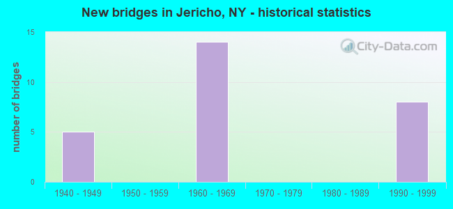
- New bridges - historical statistics
- 51940-1949
- 141960-1969
- 81990-1999

- Reconstructed bridges - Historical Statistics
- 21980-1989
- 21990-1999


- Bridge Condition - Deck
- 16.7%Very good
- 50.0%Good
- 16.7%Satisfactory
- 16.7%Fair

- Bridge Condition - Superstructure
- 26.7%Very good
- 26.7%Good
- 33.3%Satisfactory
- 13.3%Fair

- Bridge Condition - Substructure
- 6.7%Very good
- 40.0%Good
- 40.0%Satisfactory
- 13.3%Fair
Find on map >> Show street view
Structure Number: 1017369, Location: RTE 495+RTE 25 EB (Lat: 40.783194, Lng: -73.553364), Route carried "on" structure: Interstate 495, Year Built: 1962, Year Reconstructed: 1998, Status: Open, Structure Length: 2.47m (8.10ft), Average Daily Traffic: 145,449 (year 2018), Truck Traffic: 12%, Average Future Daily Traffic: 152,721 (year 2040), Design Load: HS 25 or greater, Features Intersected: RTE 25
Minimum Vertical Clearance: 30+ m (98+ ft), Kilometerpoint: 15.334, Lanes on structure: 9, Lanes under structure: 4, Base Highway Network: Yes, Owner: State Highway Agency, Approaching Roadway Width: 43.3m (142.1ft), Skew: 23 degrees, Material/Design: Steel, Design/Construction: Stringer/Multi-beam, Number Of Spans In Main Unit: 1, Length of Maximum Span: 23.4m (76.8ft), Curb-To-Curb Width: 43.3m (142.1ft), Out-to-Out Width: 45.4m (149.0ft)
Condition: Deck: Good, Superstructure: Very good, Substructure: Satisfactory, Operating Rating: 53.8 metric tons, Method Used To Determine Operating Rating: Load and Resistance Factor Rating (LRFR) rating reported by rating factor(RF) method using HL-93 loadings, Inventory Rating: 41.5 metric tons, Method Used To Determine Inventory Rating: Load and Resistance Factor Rating (LRFR) rating reported by rating factor(RF) method using HL-93 loadings, Structural Evaluation: Equal to present minimum criteria, Deck Geometry: Superior to present desirable criteria, Underclear: High priority of corrective action, Approach Roadway Alignment: Better than present minimum criteria, Length Of Structure Improvement: 2.46m (8.07ft), Designated Inspection Frequency: Every 24 months, Inspection Date: July 2020, Bridge Improvement Cost: $8,721,000, Roadway Improvement Cost: $5,107,000, Total Project Cost: $13,828,000 ( Estimate for 2021), Deck Structure Type: Concrete Cast-file-Place, Wearing Surface/Protective System: Wearing Surface: Integral Concrete, Deck Protection: Epoxy Coated Reinforcing
Find on map >> Show street view
Structure Number: 1018219, Location: RTE 25+RTE 106+ RTE 107 (Lat: 40.792069, Lng: -73.539628), Route carried "on" structure: State highway 25, Year Built: 1962, Status: Open, Structure Length: 6.46m (21.19ft), Average Daily Traffic: 27,735 (year 2019), Truck Traffic: 6%, Average Future Daily Traffic: 32,000 (year 2040), Design Load: HS 20, Features Intersected: 107 107 03011096 NWB, RT
Minimum Vertical Clearance: 30+ m (98+ ft), Kilometerpoint: 17.393, Lanes on structure: 8, Lanes under structure: 8, Base Highway Network: Yes, Owner: State Highway Agency, Approaching Roadway Width: 29.9m (98.1ft), Skew: 30 degrees, Material/Design: Steel, Design/Construction: Stringer/Multi-beam, Number Of Spans In Main Unit: 4, Length of Maximum Span: 21.6m (70.9ft), Curb or Sidewalk Widths: Left: 2.4m (7.9ft), Right: 2.4m (7.9ft), Curb-To-Curb Width: 29.9m (98.1ft), Out-to-Out Width: 38.4m (126.0ft)
Condition: Deck: Fair, Superstructure: Fair, Substructure: Fair, Operating Rating: 56.2 metric tons, Method Used To Determine Operating Rating: Load Factor (LF), Inventory Rating: 33.6 metric tons, Method Used To Determine Inventory Rating: Load Factor (LF), Structural Evaluation: Somewhat better than minimum adequacy, Deck Geometry: Meets minimum limits, Underclear: High priority of corrective action, Approach Roadway Alignment: Equal to present desirable criteria, Length Of Structure Improvement: 6.46m (21.19ft), Designated Inspection Frequency: Every 24 months, Inspection Date: September 2020, Bridge Improvement Cost: $9,477,000, Roadway Improvement Cost: $5,550,000, Total Project Cost: $15,027,000 ( Estimate for 2021), Deck Structure Type: Concrete Cast-file-Place, Wearing Surface/Protective System: Wearing Surface: Integral Concrete
Find on map >> Show street view
Structure Number: 1036799, Location: JCT NSP & SH 107 (Lat: 40.783097, Lng: -73.532650), Route carried "on" structure: State highway 107, Year Built: 1948, Status: Open, Structure Length: 2.31m (7.58ft), Average Daily Traffic: 55,307 (year 2020), Truck Traffic: 7%, Average Future Daily Traffic: 63,813 (year 2040), Design Load: H 20, Features Intersected: 908G908G03011119, RTE 90
Minimum Vertical Clearance: 30+ m (98+ ft), Kilometerpoint: 10.539, Lanes on structure: 8, Lanes under structure: 4, Base Highway Network: Yes, Owner: State Highway Agency, Approaching Roadway Width: 29.9m (98.1ft), Skew: 21 degrees, Material/Design: Concrete, Design/Construction: Arch - Deck, Number Of Spans In Main Unit: 1, Length of Maximum Span: 23.1m (75.8ft), Curb or Sidewalk Widths: Left: 1.5m (4.9ft), Right: 1.5m (4.9ft), Curb-To-Curb Width: 29.9m (98.1ft), Out-to-Out Width: 36.9m (121.1ft)
Condition: Superstructure: Satisfactory, Substructure: Good, Operating Rating: 65.3 metric tons, Method Used To Determine Operating Rating: Load Factor (LF), Inventory Rating: 34.5 metric tons, Method Used To Determine Inventory Rating: Load Factor (LF), Structural Evaluation: Equal to present minimum criteria, Deck Geometry: Meets minimum limits, Underclear: High priority of corrective action, Approach Roadway Alignment: Better than present minimum criteria, Length Of Structure Improvement: 2.34m (7.68ft), Designated Inspection Frequency: Every 24 months, Inspection Date: January 2020, Bridge Improvement Cost: $7,377,000, Roadway Improvement Cost: $4,320,000, Total Project Cost: $11,697,000 ( Estimate for 2021), Wearing Surface/Protective System: Wearing Surface: Bituminous, Membrane: Preformed Fabric
Find on map >> Show street view
Structure Number: 1036809, Location: JCT I495 & SH 106 (Lat: 40.785347, Lng: -73.533614), Route carried "on" structure: State highway 107, Year Built: 1961, Status: Open, Structure Length: 4.57m (14.99ft), Average Daily Traffic: 55,307 (year 2020), Truck Traffic: 7%, Average Future Daily Traffic: 63,813 (year 2040), Design Load: HS 20, Features Intersected: 495I495I03021106, RTE I4
Minimum Vertical Clearance: 30+ m (98+ ft), Kilometerpoint: 10.796, Lanes on structure: 8, Lanes under structure: 10, Base Highway Network: Yes, Owner: State Highway Agency, Approaching Roadway Width: 29.9m (98.1ft), Skew: 20 degrees, Material/Design: Concrete continuous, Design/Construction: Frame, Number Of Spans In Main Unit: 2, Length of Maximum Span: 21.6m (70.9ft), Curb or Sidewalk Widths: Left: 1.6m (5.2ft), Right: 1.5m (4.9ft), Curb-To-Curb Width: 29.9m (98.1ft), Out-to-Out Width: 36.2m (118.8ft)
Condition: Deck: Fair, Superstructure: Fair, Substructure: Fair, Operating Rating: 86.5 metric tons, Method Used To Determine Operating Rating: Field evaluation and documented engineering judgment, Inventory Rating: 29.4 metric tons, Method Used To Determine Inventory Rating: Field evaluation and documented engineering judgment, Structural Evaluation: Somewhat better than minimum adequacy, Deck Geometry: Meets minimum limits, Underclear: High priority of corrective action, Approach Roadway Alignment: Equal to present minimum criteria, Length Of Structure Improvement: 4.57m (14.99ft), Designated Inspection Frequency: Every 24 months, Inspection Date: May 2020, Bridge Improvement Cost: $8,444,000, Roadway Improvement Cost: $4,945,000, Total Project Cost: $13,389,000 ( Estimate for 2021), Wearing Surface/Protective System: Wearing Surface: Bituminous, Membrane: Other
Find on map >> Show street view
Structure Number: 1049179, Location: .5 MI E RTE 495+RTE 106 (Lat: 40.787944, Lng: -73.524761), Route carried "on" structure: Interstate 495, Year Built: 1961, Status: Open, Structure Length: 2.29m (7.51ft), Average Daily Traffic: 133,777 (year 2020), Truck Traffic: 14%, Average Future Daily Traffic: 140,465 (year 2040), Design Load: HS 20, Features Intersected: LIEWB CONN TO NSP
Minimum Vertical Clearance: 30+ m (98+ ft), Kilometerpoint: 17.812, Lanes on structure: 10, Lanes under structure: 2, Base Highway Network: Yes, Owner: State Highway Agency, Approaching Roadway Width: 43.6m (143.0ft), Skew: 25 degrees, Material/Design: Steel, Design/Construction: Stringer/Multi-beam, Number Of Spans In Main Unit: 1, Length of Maximum Span: 22.5m (73.8ft), Curb-To-Curb Width: 43.6m (143.0ft), Out-to-Out Width: 45.5m (149.3ft)
Condition: Deck: Satisfactory, Superstructure: Good, Substructure: Satisfactory, Operating Rating: 53.5 metric tons, Method Used To Determine Operating Rating: Load Factor (LF), Inventory Rating: 29.9 metric tons, Method Used To Determine Inventory Rating: Load Factor (LF), Structural Evaluation: Equal to present minimum criteria, Deck Geometry: Better than present minimum criteria, Underclear: High priority of corrective action, Approach Roadway Alignment: Equal to present minimum criteria, Length Of Structure Improvement: 2.28m (7.48ft), Designated Inspection Frequency: Every 24 months, Inspection Date: September 2020, Bridge Improvement Cost: $10,052,000, Roadway Improvement Cost: $5,887,000, Total Project Cost: $15,939,000 ( Estimate for 2021), Deck Structure Type: Concrete Cast-file-Place, Wearing Surface/Protective System: Wearing Surface: Integral Concrete
Find on map >> Show street view
Structure Number: 1049181, Location: 1.1MI E JCT RT106&LIE WB (Lat: 40.792997, Lng: -73.515942), Route carried "on" structure: Interstate 495, Year Built: 1990, Status: Open, Structure Length: 2.04m (6.69ft), Average Daily Traffic: 84,452 (year 2008), Truck Traffic: 13%, Design Load: HS 20, Features Intersected: LIRR PT JEFF BRCH
Minimum Vertical Clearance: 30+ m (98+ ft), Kilometerpoint: 18.761, Lanes on structure: 4, Base Highway Network: Yes, Owner: State Highway Agency, Approaching Roadway Width: 20.1m (65.9ft), Skew: 4 degrees, Material/Design: Prestressed concrete, Design/Construction: Box Beam or Girders - Multiple, Number Of Spans In Main Unit: 1, Length of Maximum Span: 19.5m (64.0ft), Curb-To-Curb Width: 20.1m (65.9ft), Out-to-Out Width: 23.3m (76.4ft)
Condition: Deck: Good, Superstructure: Good, Substructure: Good, Operating Rating: 66.2 metric tons, Method Used To Determine Operating Rating: Load Factor (LF), Inventory Rating: 32.7 metric tons, Method Used To Determine Inventory Rating: Load Factor (LF), Structural Evaluation: Better than present minimum criteria, Deck Geometry: Equal to present minimum criteria, Underclear: High priority of corrective action, Approach Roadway Alignment: Equal to present desirable criteria, Length Of Structure Improvement: 2.04m (6.69ft), Designated Inspection Frequency: Every 24 months, Inspection Date: August 2020, Bridge Improvement Cost: $3,997,000, Roadway Improvement Cost: $2,340,000, Total Project Cost: $6,337,000 ( Estimate for 2021), Wearing Surface/Protective System: Wearing Surface: Monolithic Concrete
Find on map >> Show street view
Structure Number: 1049182, Location: 1.1 MI E JCT SH106 & LIE (Lat: 40.792717, Lng: -73.515997), Route carried "on" structure: Interstate 495, Year Built: 1961, Year Reconstructed: 1991, Status: Open, Structure Length: 2.04m (6.69ft), Average Daily Traffic: 66,889 (year 2020), Truck Traffic: 14%, Average Future Daily Traffic: 70,233 (year 2040), Design Load: HS 20, Features Intersected: LIRR PT JEFF BRCH
Minimum Vertical Clearance: 30+ m (98+ ft), Kilometerpoint: 18.761, Lanes on structure: 5, Base Highway Network: Yes, Owner: State Highway Agency, Approaching Roadway Width: 21.0m (68.9ft), Skew: 4 degrees, Material/Design: Steel, Design/Construction: Stringer/Multi-beam, Number Of Spans In Main Unit: 1, Length of Maximum Span: 20.1m (65.9ft), Curb-To-Curb Width: 21.1m (69.2ft), Out-to-Out Width: 21.7m (71.2ft)
Condition: Deck: Good, Superstructure: Good, Substructure: Good, Operating Rating: 67.1 metric tons, Method Used To Determine Operating Rating: Load Factor (LF), Inventory Rating: 32.7 metric tons, Method Used To Determine Inventory Rating: Load Factor (LF), Structural Evaluation: Better than present minimum criteria, Deck Geometry: Meets minimum limits, Underclear: High priority of corrective action, Approach Roadway Alignment: Equal to present desirable criteria, Length Of Structure Improvement: 2.04m (6.69ft), Designated Inspection Frequency: Every 24 months, Inspection Date: August 2020, Bridge Improvement Cost: $4,752,000, Roadway Improvement Cost: $2,783,000, Total Project Cost: $7,535,000 ( Estimate for 2021), Deck Structure Type: Concrete Cast-file-Place, Wearing Surface/Protective System: Wearing Surface: Integral Concrete
Find on map >> Show street view
Structure Number: 1049183, Location: 1.1 MI E JCT SH106 & LIE (Lat: 40.792503, Lng: -73.516047), Route carried "on" structure: ServiceOther road 906A, Year Built: 1961, Year Reconstructed: 1991, Status: Open, Structure Length: 2.04m (6.69ft), Average Daily Traffic: 1,673 (year 2020), Truck Traffic: 3%, Average Future Daily Traffic: 1,930 (year 2040), Design Load: HS 20, Features Intersected: LIRR PT JEFF BRCH
Minimum Vertical Clearance: 30+ m (98+ ft), Kilometerpoint: 18.857, Lanes on structure: 2, Base Highway Network: Yes, Owner: State Highway Agency, Approaching Roadway Width: 12.8m (42.0ft), Skew: 4 degrees, Material/Design: Steel, Design/Construction: Stringer/Multi-beam, Number Of Spans In Main Unit: 1, Length of Maximum Span: 20.1m (65.9ft), Curb-To-Curb Width: 12.8m (42.0ft), Out-to-Out Width: 20.6m (67.6ft)
Condition: Deck: Very good, Superstructure: Good, Substructure: Good, Operating Rating: 81.6 metric tons, Method Used To Determine Operating Rating: Load Factor (LF), Inventory Rating: 32.7 metric tons, Method Used To Determine Inventory Rating: Load Factor (LF), Structural Evaluation: Better than present minimum criteria, Deck Geometry: Equal to present desirable criteria, Underclear: High priority of corrective action, Approach Roadway Alignment: Equal to present desirable criteria, Length Of Structure Improvement: 2.04m (6.69ft), Designated Inspection Frequency: Every 24 months, Inspection Date: August 2020, Bridge Improvement Cost: $4,399,000, Roadway Improvement Cost: $2,576,000, Total Project Cost: $6,975,000 ( Estimate for 2021), Deck Structure Type: Concrete Cast-file-Place, Wearing Surface/Protective System: Wearing Surface: Integral Concrete
Find on map >> Show street view
Structure Number: 105048, Location: .7 MI NE JCT NSP+RTE 107 (Lat: 40.788472, Lng: -73.520789), Route carried "on" structure: Ramp State highway , Year Built: 1961, Status: Open, Structure Length: 2.86m (9.38ft), Truck Traffic: 10%, Design Load: HS 20, Features Intersected: 908G908G0311127 WB, RTE, Facility Carried by Structure: 495I EB TO NSP EB
Minimum Vertical Clearance: 30+ m (98+ ft), Kilometerpoint: 0.386, Lanes on structure: 1, Lanes under structure: 4, Owner: State Highway Agency, Approaching Roadway Width: 8.5m (27.9ft), Skew: 3 degrees, Material/Design: Concrete, Design/Construction: Frame, Number Of Spans In Main Unit: 1, Length of Maximum Span: 28.6m (93.8ft), Curb or Sidewalk Widths: Left: 0.6m (2.0ft), Right: 2.5m (8.2ft), Curb-To-Curb Width: 8.7m (28.5ft), Out-to-Out Width: 13.0m (42.7ft)
Condition: Superstructure: Satisfactory, Substructure: Satisfactory, Operating Rating: 77.1 metric tons, Method Used To Determine Operating Rating: Load Factor (LF), Inventory Rating: 46.3 metric tons, Method Used To Determine Inventory Rating: Load Factor (LF), Structural Evaluation: Equal to present minimum criteria, Deck Geometry: Superior to present desirable criteria, Underclear: High priority of corrective action, Approach Roadway Alignment: Equal to present minimum criteria, Length Of Structure Improvement: 2.89m (9.48ft), Designated Inspection Frequency: Every 24 months, Inspection Date: January 2020, Bridge Improvement Cost: $2,252,000, Roadway Improvement Cost: $1,319,000, Total Project Cost: $3,571,000 ( Estimate for 2021), Wearing Surface/Protective System: Wearing Surface: Monolithic Concrete
Find on map >> Show street view
Structure Number: 10571, Location: 0.5M E JCT RTS106&LIESSR (Lat: 40.786706, Lng: -73.525447), Route carried "on" structure: ServiceState highway 906A, Year Built: 1990, Status: Open, Structure Length: 2.10m (6.89ft), Average Daily Traffic: 1,673 (year 2020), Truck Traffic: 3%, Average Future Daily Traffic: 1,930 (year 2040), Design Load: HS 20, Features Intersected: RTE I495
Minimum Vertical Clearance: 30+ m (98+ ft), Kilometerpoint: 17.828, Lanes on structure: 2, Lanes under structure: 2, Base Highway Network: Yes, Owner: State Highway Agency, Approaching Roadway Width: 11.6m (38.1ft), Skew: 4 degrees, Material/Design: Prestressed concrete, Design/Construction: Box Beam or Girders - Multiple, Number Of Spans In Main Unit: 1, Length of Maximum Span: 20.4m (66.9ft), Curb-To-Curb Width: 11.6m (38.1ft), Out-to-Out Width: 12.6m (41.3ft)
Condition: Deck: Good, Superstructure: Satisfactory, Substructure: Good, Operating Rating: 54.4 metric tons, Method Used To Determine Operating Rating: Load Factor (LF), Inventory Rating: 32.7 metric tons, Method Used To Determine Inventory Rating: Load Factor (LF), Structural Evaluation: Equal to present minimum criteria, Deck Geometry: Better than present minimum criteria, Underclear: High priority of corrective action, Approach Roadway Alignment: Equal to present desirable criteria, Length Of Structure Improvement: 2.10m (6.89ft), Designated Inspection Frequency: Every 24 months, Inspection Date: August 2021, Bridge Improvement Cost: $1,709,000, Roadway Improvement Cost: $1,001,000, Total Project Cost: $2,709,000 ( Estimate for 2021), Wearing Surface/Protective System: Wearing Surface: Integral Concrete
Find on map >> Show street view
Structure Number: 105711, Location: LIE EXIT 42 TO NSP OV SSR (Lat: 40.788422, Lng: -73.522133), Route carried "on" structure: Ramp Other road , Year Built: 1990, Status: Open, Structure Length: 7.01m (23.00ft), Truck Traffic: 10%, Design Load: HS 20, Features Intersected: RTE 906A, Facility Carried by Structure: 495I EB TO NSP EB
Minimum Vertical Clearance: 30+ m (98+ ft), Kilometerpoint: 0.257, Lanes on structure: 1, Lanes under structure: 2, Owner: State Highway Agency, Approaching Roadway Width: 7.6m (24.9ft), Material/Design: Steel continuous, Design/Construction: Stringer/Multi-beam, Number Of Spans In Main Unit: 3, Length of Maximum Span: 27.7m (90.9ft), Curb-To-Curb Width: 7.6m (24.9ft), Out-to-Out Width: 8.4m (27.6ft)
Condition: Deck: Good, Superstructure: Very good, Substructure: Very good, Operating Rating: 69.9 metric tons, Method Used To Determine Operating Rating: Load Factor (LF), Inventory Rating: 35.4 metric tons, Method Used To Determine Inventory Rating: Load Factor (LF), Structural Evaluation: Equal to present desirable criteria, Deck Geometry: Better than present minimum criteria, Underclear: Meets minimum limits, Approach Roadway Alignment: Equal to present minimum criteria, Length Of Structure Improvement: 7.01m (23.00ft), Designated Inspection Frequency: Every 24 months, Inspection Date: August 2021, Bridge Improvement Cost: $2,394,000, Roadway Improvement Cost: $1,402,000, Total Project Cost: $3,796,000 ( Estimate for 2021), Deck Structure Type: Concrete Cast-file-Place, Wearing Surface/Protective System: Wearing Surface: Integral Concrete, Deck Protection: Epoxy Coated Reinforcing
Find on map >> Show street view
Structure Number: 105718, Location: 1.1 MI E JCT LIE & SH106 (Lat: 40.793208, Lng: -73.515914), Route carried "on" structure: ServiceOther road 906B, Year Built: 1990, Status: Open, Structure Length: 2.01m (6.59ft), Average Daily Traffic: 3,564 (year 2020), Truck Traffic: 5%, Average Future Daily Traffic: 4,112 (year 2040), Design Load: HS 20, Features Intersected: LIRR PT JEFF BRCH
Minimum Vertical Clearance: 30+ m (98+ ft), Kilometerpoint: 6.420, Lanes on structure: 2, Base Highway Network: Yes, Owner: State Highway Agency, Approaching Roadway Width: 12.2m (40.0ft), Skew: 4 degrees, Material/Design: Prestressed concrete, Design/Construction: Box Beam or Girders - Multiple, Number Of Spans In Main Unit: 1, Length of Maximum Span: 19.2m (63.0ft), Curb-To-Curb Width: 12.3m (40.4ft), Out-to-Out Width: 13.2m (43.3ft)
Condition: Deck: Very good, Superstructure: Very good, Substructure: Good, Operating Rating: 58.1 metric tons, Method Used To Determine Operating Rating: Load Factor (LF), Inventory Rating: 41.7 metric tons, Method Used To Determine Inventory Rating: Load Factor (LF), Structural Evaluation: Better than present minimum criteria, Deck Geometry: Better than present minimum criteria, Underclear: High priority of corrective action, Approach Roadway Alignment: Equal to present desirable criteria, Length Of Structure Improvement: 2.01m (6.59ft), Designated Inspection Frequency: Every 24 months, Inspection Date: August 2020, Bridge Improvement Cost: $2,148,000, Roadway Improvement Cost: $1,258,000, Total Project Cost: $3,406,000 ( Estimate for 2021), Wearing Surface/Protective System: Wearing Surface: Monolithic Concrete
Find on map >> Show street view
Structure Number: 105821, Location: .9 MI E NSP+WSP (Lat: 40.773694, Lng: -73.551033), Route carried "on" structure: County highway , Year Built: 1947, Status: Open, Structure Length: 2.19m (7.19ft), Average Daily Traffic: 6,743 (year 2020), Truck Traffic: 15%, Average Future Daily Traffic: 8,343 (year 2040), Design Load: H 20, Features Intersected: 908G908G03011107, RTE 90, Facility Carried by Structure: CANTIAGUE ROCK RD
Minimum Vertical Clearance: 30+ m (98+ ft), Kilometerpoint: 0.949, Lanes on structure: 2, Lanes under structure: 4, Owner: State Highway Agency, Approaching Roadway Width: 10.4m (34.1ft), Material/Design: Concrete, Design/Construction: Frame, Number Of Spans In Main Unit: 1, Length of Maximum Span: 20.7m (67.9ft), Curb or Sidewalk Widths: Left: 0.9m (3.0ft), Right: 0.3m (1.0ft), Curb-To-Curb Width: 10.4m (34.1ft), Out-to-Out Width: 13.7m (44.9ft)
Condition: Superstructure: Satisfactory, Substructure: Satisfactory, Operating Rating: 59.4 metric tons, Method Used To Determine Operating Rating: Field evaluation and documented engineering judgment, Inventory Rating: 23.2 metric tons, Method Used To Determine Inventory Rating: Field evaluation and documented engineering judgment, Structural Evaluation: Somewhat better than minimum adequacy, Deck Geometry: Meets minimum limits, Underclear: High priority of corrective action, Approach Roadway Alignment: Equal to present desirable criteria, Length Of Structure Improvement: 2.19m (7.19ft), Designated Inspection Frequency: Every 24 months, Inspection Date: Febuary 2020, Bridge Improvement Cost: $1,665,000, Roadway Improvement Cost: $975,000, Total Project Cost: $2,640,000 ( Estimate for 2021), Wearing Surface/Protective System: Wearing Surface: Bituminous, Membrane: Preformed Fabric
Find on map >> Show street view
Structure Number: 1058239, Location: 1 MI NE JCT NSP+ROUTE 107 (Lat: 40.791242, Lng: -73.516286), Route carried "on" structure: State highway 908G, Year Built: 1947, Status: Open, Structure Length: 1.43m (4.69ft), Average Daily Traffic: 66,160 (year 2018), Average Future Daily Traffic: 78,697 (year 2040), Design Load: H 20, Features Intersected: LIRR-PT JEFF BRCH
Minimum Vertical Clearance: 30+ m (98+ ft), Kilometerpoint: 20.804, Lanes on structure: 4, Base Highway Network: Yes, Owner: State Highway Agency, Approaching Roadway Width: 19.5m (64.0ft), Skew: 22 degrees, Material/Design: Concrete, Design/Construction: Frame, Number Of Spans In Main Unit: 1, Length of Maximum Span: 14.0m (45.9ft), Curb-To-Curb Width: 19.5m (64.0ft), Out-to-Out Width: 21.8m (71.5ft)
Condition: Deck: Satisfactory, Superstructure: Satisfactory, Substructure: Satisfactory, Operating Rating: 57.7 metric tons, Method Used To Determine Operating Rating: Field evaluation and documented engineering judgment, Inventory Rating: 23.8 metric tons, Method Used To Determine Inventory Rating: Field evaluation and documented engineering judgment, Structural Evaluation: Somewhat better than minimum adequacy, Deck Geometry: Somewhat better than minimum adequacy, Underclear: High priority of corrective action, Approach Roadway Alignment: Equal to present desirable criteria, Length Of Structure Improvement: 1.43m (4.69ft), Designated Inspection Frequency: Every 24 months, Inspection Date: September 2020, Bridge Improvement Cost: $2,683,000, Roadway Improvement Cost: $1,571,000, Total Project Cost: $4,255,000 ( Estimate for 2021), Wearing Surface/Protective System: Wearing Surface: Bituminous
Find on map >> Show street view
Structure Number: 1063029, Location: RTE 495+RTE 25 WB (Lat: 40.782664, Lng: -73.556933), Route carried "on" structure: Interstate 495, Year Built: 1962, Year Reconstructed: 1998, Status: Open, Structure Length: 2.47m (8.10ft), Average Daily Traffic: 145,449 (year 2018), Truck Traffic: 12%, Average Future Daily Traffic: 152,721 (year 2040), Design Load: HS 25 or greater, Features Intersected: RTE 25
Minimum Vertical Clearance: 30+ m (98+ ft), Kilometerpoint: 15.028, Lanes on structure: 9, Lanes under structure: 3, Base Highway Network: Yes, Owner: State Highway Agency, Approaching Roadway Width: 43.0m (141.1ft), Skew: 23 degrees, Material/Design: Steel, Design/Construction: Stringer/Multi-beam, Number Of Spans In Main Unit: 1, Length of Maximum Span: 23.4m (76.8ft), Curb-To-Curb Width: 43.2m (141.7ft), Out-to-Out Width: 45.3m (148.6ft)
Condition: Deck: Good, Superstructure: Very good, Substructure: Satisfactory, Operating Rating: 81.6 metric tons, Method Used To Determine Operating Rating: Load Factor (LF), Inventory Rating: 47.2 metric tons, Method Used To Determine Inventory Rating: Load Factor (LF), Structural Evaluation: Equal to present minimum criteria, Deck Geometry: Superior to present desirable criteria, Underclear: High priority of corrective action, Approach Roadway Alignment: Better than present minimum criteria, Length Of Structure Improvement: 2.46m (8.07ft), Designated Inspection Frequency: Every 24 months, Inspection Date: July 2020, Bridge Improvement Cost: $8,593,000, Roadway Improvement Cost: $5,032,000, Total Project Cost: $13,625,000 ( Estimate for 2021), Deck Structure Type: Concrete Cast-file-Place, Wearing Surface/Protective System: Wearing Surface: Integral Concrete, Deck Protection: Epoxy Coated Reinforcing
Find on map >> Show street view
Structure Number: 1017369, Location: RTE 495+RTE 25 EB (Lat: 40.783194, Lng: -73.553364), Route carried "under" structure: State highway 25, Year Built: 1962, Structure Length: 0. m, Average Daily Traffic: 37,803 (year 1999), Features Intersected: RTE 25, Facility Carried by Structure: RTE I495
Minimum Vertical Clearance: 4.74m (15.55ft), Kilometerpoint: 16.701, Lanes on structure: 9, Lanes under structure: 4, Material/Design: Steel, Design/Construction: Stringer/Multi-beam, Length of Maximum Span: 23.4m (76.8ft)
Find on map >> Show street view
Structure Number: 1018219, Location: RTE 25+RTE 106+ RTE 107 (Lat: 40.792069, Lng: -73.539628), Route carried "under" structure: State highway 107, Year Built: 1962, Structure Length: 0. m, Average Daily Traffic: 62,479 (year 2002), Features Intersected: 107 107 03011096 NWB, RT, Facility Carried by Structure: RTE 25
Minimum Vertical Clearance: 4.83m (15.85ft), Kilometerpoint: 17.635, Lanes on structure: 8, Lanes under structure: 4, Material/Design: Steel, Design/Construction: Stringer/Multi-beam, Length of Maximum Span: 21.6m (70.9ft)
Find on map >> Show street view
Structure Number: 1036799, Location: JCT NSP & SH 107 (Lat: 40.783097, Lng: -73.532650), Route carried "under" structure: State highway 908G, Year Built: 1948, Structure Length: 0. m, Average Daily Traffic: 80,855 (year 2002), Features Intersected: 908G908G03011119, RTE 90, Facility Carried by Structure: RTE 107
Minimum Vertical Clearance: 4.22m (13.85ft), Kilometerpoint: 19.179, Lanes on structure: 8, Lanes under structure: 2, Material/Design: Concrete, Design/Construction: Arch - Deck, Length of Maximum Span: 23.1m (75.8ft)
Find on map >> Show street view
Structure Number: 1036809, Location: JCT I495 & SH 106 (Lat: 40.785347, Lng: -73.533614), Route carried "under" structure: Interstate 495, Year Built: 1961, Structure Length: 0. m, Average Daily Traffic: 161,868 (year 2002), Features Intersected: 495I495I03021106, RTE I4, Facility Carried by Structure: RTE 107
Minimum Vertical Clearance: 5.16m (16.93ft), Kilometerpoint: 17.007, Lanes on structure: 8, Lanes under structure: 5, Material/Design: Concrete continuous, Design/Construction: Frame, Length of Maximum Span: 21.6m (70.9ft)
Find on map >> Show street view
Structure Number: 104916, Location: .4 MI W JCT I495 & SH 106 (Lat: 40.783822, Lng: -73.541161), Route carried "under" structure: Interstate 495, Year Built: 1997, Structure Length: 0. m, Features Intersected: 495I495I03021102, RTE I4, Facility Carried by Structure: AT LEAHY ST
Minimum Vertical Clearance: 5.05m (16.57ft), Kilometerpoint: 16.347, Lanes under structure: 4, Material/Design: Prestressed concrete, Design/Construction: Box Beam or Girders - Multiple, Length of Maximum Span: 27.4m (89.9ft)
Find on map >> Show street view
Structure Number: 104916, Location: .4 MI W JCT I495 & SH 106 (Lat: 40.783822, Lng: -73.541161), Route carried "under" structure: Interstate , Year Built: 1997, Structure Length: 0. m, Features Intersected: 495I495I03021102, RTE I4, Facility Carried by Structure: AT LEAHY ST
Minimum Vertical Clearance: 5.26m (17.26ft), Kilometerpoint: 16.347, Lanes under structure: 4, Material/Design: Prestressed concrete, Design/Construction: Box Beam or Girders - Multiple, Length of Maximum Span: 27.4m (89.9ft)
Find on map >> Show street view
Structure Number: 1049179, Location: .5 MI E RTE 495+RTE 106 (Lat: 40.787944, Lng: -73.524761), Route carried "under" structure: Ramp Other road , Year Built: 1961, Structure Length: 0. m, Average Daily Traffic: 15,000 (year 2021), Features Intersected: LIEWB CONN TO NSP, Facility Carried by Structure: RTE I495
Minimum Vertical Clearance: 4.34m (14.24ft), Kilometerpoint: 0.000, Lanes on structure: 10, Lanes under structure: 2, Material/Design: Steel, Design/Construction: Stringer/Multi-beam, Length of Maximum Span: 22.5m (73.8ft)
Find on map >> Show street view
Structure Number: 105048, Location: .7 MI NE JCT NSP+RTE 107 (Lat: 40.788472, Lng: -73.520789), Route carried "under" structure: State highway 908G, Year Built: 1961, Structure Length: 0. m, Average Daily Traffic: 80,855 (year 2002), Features Intersected: 908G908G0311127 WB, RTE, Facility Carried by Structure: 495I EB TO NSP EB
Minimum Vertical Clearance: 4.37m (14.34ft), Kilometerpoint: 20.434, Lanes on structure: 1, Lanes under structure: 2, Material/Design: Concrete, Design/Construction: Frame, Length of Maximum Span: 28.6m (93.8ft)
Find on map >> Show street view
Structure Number: 10571, Location: 0.5M E JCT RTS106&LIESSR (Lat: 40.786706, Lng: -73.525447), Route carried "under" structure: Ramp Other road 495, Year Built: 1990, Structure Length: 0. m, Average Daily Traffic: 10,000 (year 2021), Features Intersected: RTE I495, Facility Carried by Structure: RTE 906A
Minimum Vertical Clearance: 4.62m (15.16ft), Kilometerpoint: 0.000, Lanes on structure: 2, Lanes under structure: 2, Material/Design: Prestressed concrete, Design/Construction: Box Beam or Girders - Multiple, Length of Maximum Span: 20.4m (66.9ft)
Find on map >> Show street view
Structure Number: 105711, Location: LIE EXIT 42 TO NSP OV SSR (Lat: 40.788422, Lng: -73.522133), Route carried "under" structure: ServiceOther road 906A, Year Built: 1990, Structure Length: 0. m, Average Daily Traffic: 100 (year 2021), Features Intersected: RTE 906A, Facility Carried by Structure: 495I EB TO NSP EB
Minimum Vertical Clearance: 5.18m (16.99ft), Kilometerpoint: 0.000, Lanes on structure: 1, Lanes under structure: 2, Material/Design: Steel continuous, Design/Construction: Stringer/Multi-beam, Length of Maximum Span: 27.7m (90.9ft)
Find on map >> Show street view
Structure Number: 105821, Location: .9 MI E NSP+WSP (Lat: 40.773694, Lng: -73.551033), Route carried "under" structure: State highway 908G, Year Built: 1947, Structure Length: 0. m, Average Daily Traffic: 112,527 (year 2002), Features Intersected: 908G908G03011107, RTE 90, Facility Carried by Structure: CANTIAGUE ROCK RD
Minimum Vertical Clearance: 3.86m (12.66ft), Kilometerpoint: 17.265, Lanes on structure: 2, Lanes under structure: 2, Material/Design: Concrete, Design/Construction: Frame, Length of Maximum Span: 20.7m (67.9ft)
Find on map >> Show street view
Structure Number: 1063029, Location: RTE 495+RTE 25 WB (Lat: 40.782664, Lng: -73.556933), Route carried "under" structure: State highway 25, Year Built: 1962, Structure Length: 0. m, Average Daily Traffic: 37,803 (year 1999), Features Intersected: RTE 25, Facility Carried by Structure: RTE I495
Minimum Vertical Clearance: 4.62m (15.16ft), Kilometerpoint: 16.701, Lanes on structure: 9, Lanes under structure: 3, Material/Design: Steel, Design/Construction: Stringer/Multi-beam, Length of Maximum Span: 23.4m (76.8ft)