Bridge Statistics for La Crescenta-Montrose, California (CA)
Condition, Traffic, Stress, Structural Evaluation, Project Costs
- National Bridge Inventory (NBI) Statistics
- 26Number of bridges
- 226ft / 69.2mTotal length
- 1,397,423Total average daily traffic
- 86,803Total average daily truck traffic
- National Bridge Inventory (NBI) Registered Bridges for La Crescenta-Montrose
- No street view available for this location
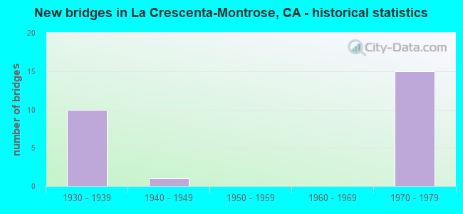
- New bridges - historical statistics
- 101930-1939
- 11940-1949
- 151970-1979


- Bridge Condition - Deck
- 87.5%Good
- 12.5%Fair

- Bridge Condition - Superstructure
- 93.8%Good
- 6.3%Fair

- Bridge Condition - Channel
- 84.6%Excellent
- 15.4%Very good
Find on map >> Show street view
Structure Number: 53 2219, Location: 07-LA-210-R18.53 (Lat: 34.209558, Lng: -118.223031), Route carried "on" structure: Interstate 210, Year Built: 1972, Status: Open, Structure Length: 7.00m (22.97ft), Average Daily Traffic: 166,000 (year 2018), Truck Traffic: 6%, Average Future Daily Traffic: 160,105 (year 2041), Design Load: HS 20, Features Intersected: WALTONIA DR
Minimum Vertical Clearance: 30+ m (98+ ft), Kilometerpoint: 18.530, Lanes on structure: 8, Lanes under structure: 2, Base Highway Network: Yes (Inventory Route: 2, Subroute: 1), Owner: State Highway Agency, Approaching Roadway Width: 43.9m (144.0ft), Skew: 33 degrees, Material/Design: Concrete continuous, Design/Construction: Box Beam or Girders - Multiple, Number Of Spans In Main Unit: 3, Length of Maximum Span: 29.2m (95.8ft), Curb-To-Curb Width: 43.9m (144.0ft), Out-to-Out Width: 45.1m (148.0ft)
Condition: Deck: Good, Superstructure: Good, Substructure: Good, Operating Rating: 49.2 metric tons, Method Used To Determine Operating Rating: Load and Resistance Factor Rating (LRFR) rating reported by rating factor(RF) method using HL-93 loadings, Inventory Rating: 37.9 metric tons, Method Used To Determine Inventory Rating: Load and Resistance Factor Rating (LRFR) rating reported by rating factor(RF) method using HL-93 loadings, Structural Evaluation: Better than present minimum criteria, Deck Geometry: Superior to present desirable criteria, Underclear: Superior to present desirable criteria, Approach Roadway Alignment: Superior to present desirable criteria, Designated Inspection Frequency: Every 24 months, Inspection Date: September 2020, Deck Structure Type: Concrete Cast-file-Place
Find on map >> Show street view
Structure Number: 53 2221S, Location: 07-LA-210-R18.57 (Lat: 34.209164, Lng: -118.222856), Route carried "on" structure: Ramp Interstate 210, Year Built: 1972, Status: Open, Structure Length: 4.13m (13.55ft), Average Daily Traffic: 5,300 (year 2018), Truck Traffic: 2%, Average Future Daily Traffic: 7,162 (year 2041), Design Load: HS 20, Features Intersected: WALTONIA DRIVE
Minimum Vertical Clearance: 30+ m (98+ ft), Kilometerpoint: 18.570, Lanes on structure: 1, Lanes under structure: 2, Base Highway Network: Yes (Inventory Route: 2, Subroute: 1), Owner: State Highway Agency, Approaching Roadway Width: 7.3m (24.0ft), Skew: 1 degrees, Material/Design: Prestressed concrete, Design/Construction: Box Beam or Girders - Multiple, Number Of Spans In Main Unit: 1, Length of Maximum Span: 40.7m (133.5ft), Curb-To-Curb Width: 7.3m (24.0ft), Out-to-Out Width: 7.9m (25.9ft)
Condition: Deck: Good, Superstructure: Good, Substructure: Good, Operating Rating: 84.2 metric tons, Method Used To Determine Operating Rating: Load Factor (LF), Inventory Rating: 32.4 metric tons, Method Used To Determine Inventory Rating: Load Factor (LF), Structural Evaluation: Better than present minimum criteria, Deck Geometry: Better than present minimum criteria, Underclear: Superior to present desirable criteria, Approach Roadway Alignment: Equal to present desirable criteria, Designated Inspection Frequency: Every 24 months, Inspection Date: September 2020, Deck Structure Type: Concrete Cast-file-Place
Find on map >> Show street view
Structure Number: 53 2283, Location: 07-LA-210-R17.72 (Lat: 34.216475, Lng: -118.235269), Route carried "on" structure: City street , Year Built: 1972, Status: Open, Structure Length: 10.82m (35.50ft), Average Daily Traffic: 3,500 (year 2017), Truck Traffic: 2%, Average Future Daily Traffic: 4,704 (year 2041), Design Load: HS 20, Features Intersected: ROUTE 210, Facility Carried by Structure: ROSEMONT AVE
Minimum Vertical Clearance: 30+ m (98+ ft), Kilometerpoint: 0.000, Lanes on structure: 2, Lanes under structure: 11, Owner: State Highway Agency, Approaching Roadway Width: 12.8m (42.0ft), Skew: 3 degrees, Material/Design: Prestressed concrete continuous, Design/Construction: Box Beam or Girders - Multiple, Number Of Spans In Main Unit: 2, Length of Maximum Span: 59.1m (193.9ft), Curb or Sidewalk Widths: Left: 2.1m (6.9ft), Right: 2.1m (6.9ft), Curb-To-Curb Width: 12.8m (42.0ft), Out-to-Out Width: 17.7m (58.1ft)
Condition: Deck: Fair, Superstructure: Good, Substructure: Good, Operating Rating: 35.6 metric tons, Method Used To Determine Operating Rating: Load and Resistance Factor Rating (LRFR) rating reported by rating factor(RF) method using HL-93 loadings, Inventory Rating: 25.3 metric tons, Method Used To Determine Inventory Rating: Load and Resistance Factor Rating (LRFR) rating reported by rating factor(RF) method using HL-93 loadings, Structural Evaluation: Equal to present minimum criteria, Deck Geometry: Equal to present minimum criteria, Underclear: Meets minimum limits, Approach Roadway Alignment: Equal to present desirable criteria, Designated Inspection Frequency: Every 24 months, Inspection Date: August 2020, Deck Structure Type: Concrete Cast-file-Place
Find on map >> Show street view
Structure Number: 53 2312, Location: 07-LA-210-R18.22 (Lat: 34.212425, Lng: -118.228086), Route carried "on" structure: City street Q259, Year Built: 1972, Status: Open, Structure Length: 11.03m (36.19ft), Average Daily Traffic: 13,756 (year 2015), Truck Traffic: 2%, Average Future Daily Traffic: 18,705 (year 2041), Design Load: HS 20, Features Intersected: INTERSTATE 210, Facility Carried by Structure: OCEAN VIEW BLVD
Minimum Vertical Clearance: 30+ m (98+ ft), Kilometerpoint: 0.000, Lanes on structure: 6, Lanes under structure: 12, Owner: State Highway Agency, Approaching Roadway Width: 24.4m (80.1ft), Skew: 2 degrees, Material/Design: Prestressed concrete continuous, Design/Construction: Box Beam or Girders - Multiple, Number Of Spans In Main Unit: 2, Length of Maximum Span: 64.4m (211.3ft), Curb or Sidewalk Widths: Left: 2.1m (6.9ft), Right: 2.1m (6.9ft), Curb-To-Curb Width: 24.4m (80.1ft), Out-to-Out Width: 29.3m (96.1ft)
Condition: Deck: Good, Superstructure: Good, Substructure: Good, Operating Rating: 58.6 metric tons, Method Used To Determine Operating Rating: Load and Resistance Factor Rating (LRFR) rating reported by rating factor(RF) method using HL-93 loadings, Inventory Rating: 36.9 metric tons, Method Used To Determine Inventory Rating: Load and Resistance Factor Rating (LRFR) rating reported by rating factor(RF) method using HL-93 loadings, Structural Evaluation: Better than present minimum criteria, Deck Geometry: Somewhat better than minimum adequacy, Underclear: Meets minimum limits, Approach Roadway Alignment: Equal to present desirable criteria, Designated Inspection Frequency: Every 24 months, Inspection Date: August 2020, Deck Structure Type: Concrete Cast-file-Place
Find on map >> Show street view
Structure Number: 53 2313, Location: 07-LA-210-R17.38 (Lat: 34.219244, Lng: -118.240125), Route carried "on" structure: City street L591, Year Built: 1972, Status: Open, Structure Length: 11.36m (37.27ft), Average Daily Traffic: 9,800 (year 2015), Truck Traffic: 1%, Average Future Daily Traffic: 13,254 (year 2041), Design Load: HS 20, Features Intersected: ROUTE 210, Facility Carried by Structure: LA CRESCENTA AVE
Minimum Vertical Clearance: 30+ m (98+ ft), Kilometerpoint: 0.000, Lanes on structure: 5, Lanes under structure: 10, Owner: State Highway Agency, Approaching Roadway Width: 23.7m (77.8ft), Skew: 23 degrees, Material/Design: Prestressed concrete continuous, Design/Construction: Box Beam or Girders - Multiple, Number Of Spans In Main Unit: 2, Length of Maximum Span: 56.9m (186.7ft), Curb or Sidewalk Widths: Left: 2.1m (6.9ft), Right: 2.1m (6.9ft), Curb-To-Curb Width: 23.7m (77.8ft), Out-to-Out Width: 28.7m (94.2ft)
Condition: Deck: Good, Superstructure: Good, Substructure: Good, Operating Rating: 64.2 metric tons, Method Used To Determine Operating Rating: Load and Resistance Factor Rating (LRFR) rating reported by rating factor(RF) method using HL-93 loadings, Inventory Rating: 45.4 metric tons, Method Used To Determine Inventory Rating: Load and Resistance Factor Rating (LRFR) rating reported by rating factor(RF) method using HL-93 loadings, Structural Evaluation: Better than present minimum criteria, Deck Geometry: Better than present minimum criteria, Underclear: Meets minimum limits, Approach Roadway Alignment: Equal to present desirable criteria, Designated Inspection Frequency: Every 24 months, Inspection Date: August 2020, Deck Structure Type: Concrete Cast-file-Place
Find on map >> Show street view
Structure Number: 53 2319, Location: 07-LA-210-R18.01 (Lat: 34.214014, Lng: -118.230942), Route carried "on" structure: City street , Year Built: 1972, Status: Open, Structure Length: 14.21m (46.62ft), Average Daily Traffic: 1,400 (year 2015), Truck Traffic: 1%, Average Future Daily Traffic: 2,094 (year 2041), Design Load: HS 20, Features Intersected: INTERSTATE 210, Facility Carried by Structure: BRIGGS AVENUE
Minimum Vertical Clearance: 30+ m (98+ ft), Kilometerpoint: 0.000, Lanes on structure: 2, Lanes under structure: 14, Owner: State Highway Agency, Approaching Roadway Width: 12.8m (42.0ft), Skew: 2 degrees, Material/Design: Prestressed concrete continuous, Design/Construction: Box Beam or Girders - Multiple, Number Of Spans In Main Unit: 4, Length of Maximum Span: 52.5m (172.2ft), Curb or Sidewalk Widths: Left: 2.1m (6.9ft), Right: 2.1m (6.9ft), Curb-To-Curb Width: 12.8m (42.0ft), Out-to-Out Width: 17.7m (58.1ft)
Condition: Deck: Good, Superstructure: Good, Substructure: Good, Operating Rating: 64.8 metric tons, Method Used To Determine Operating Rating: Load and Resistance Factor Rating (LRFR) rating reported by rating factor(RF) method using HL-93 loadings, Inventory Rating: 46.7 metric tons, Method Used To Determine Inventory Rating: Load and Resistance Factor Rating (LRFR) rating reported by rating factor(RF) method using HL-93 loadings, Structural Evaluation: Better than present minimum criteria, Deck Geometry: Better than present minimum criteria, Underclear: Meets minimum limits, Approach Roadway Alignment: Equal to present desirable criteria, Designated Inspection Frequency: Every 24 months, Inspection Date: August 2020, Deck Structure Type: Concrete Cast-file-Place
Find on map >> Show street view
Structure Number: 53 2338S, Location: 07-LA-210-R18.13 (Lat: 34.211814, Lng: -118.229522), Route carried "on" structure: Ramp Interstate 210, Year Built: 1972, Status: Open, Structure Length: 0.79m (2.59ft), Average Daily Traffic: 6,000 (year 2015), Truck Traffic: 2%, Average Future Daily Traffic: 7,322 (year 2041), Design Load: HS 20, Features Intersected: HALLS CYN CHN (OFF-RAMP)
Minimum Vertical Clearance: 30+ m (98+ ft), Kilometerpoint: 18.130, Lanes on structure: 2, Base Highway Network: Yes (Inventory Route: 2, Subroute: 1), Owner: State Highway Agency, Approaching Roadway Width: 9.8m (32.2ft), Skew: 1 degrees, Material/Design: Concrete, Design/Construction: Culvert, Number Of Spans In Main Unit: 1, Length of Maximum Span: 7.0m (23.0ft), Curb-To-Curb Width: 9.8m (32.2ft), Out-to-Out Width: 12.0m (39.4ft)
Condition: Channel: Very good, Culverts: Good, Operating Rating: 54.1 metric tons, Method Used To Determine Operating Rating: Field evaluation and documented engineering judgment, Inventory Rating: 32.4 metric tons, Method Used To Determine Inventory Rating: Field evaluation and documented engineering judgment, Structural Evaluation: Better than present minimum criteria, Deck Geometry: Equal to present minimum criteria, Waterway Adequacy: Equal to present desirable criteria, Approach Roadway Alignment: Equal to present desirable criteria, Designated Inspection Frequency: Every 24 months, Inspection Date: August 2020
Find on map >> Show street view
Structure Number: 53 2339K, Location: 07-LA-210-R18.15 (Lat: 34.212744, Lng: -118.228803), Route carried "on" structure: Ramp Interstate 210, Year Built: 1972, Status: Open, Structure Length: 0.76m (2.49ft), Average Daily Traffic: 6,000 (year 2015), Truck Traffic: 2%, Average Future Daily Traffic: 7,588 (year 2041), Design Load: HS 20, Features Intersected: HALLS CYN CHNL (ON-RAMP)
Minimum Vertical Clearance: 30+ m (98+ ft), Kilometerpoint: 18.150, Lanes on structure: 2, Base Highway Network: Yes (Inventory Route: 2, Subroute: 1), Owner: State Highway Agency, Approaching Roadway Width: 9.8m (32.2ft), Skew: 1 degrees, Material/Design: Concrete, Design/Construction: Culvert, Number Of Spans In Main Unit: 1, Length of Maximum Span: 7.0m (23.0ft), Curb-To-Curb Width: 9.8m (32.2ft), Out-to-Out Width: 10.0m (32.8ft)
Condition: Channel: Very good, Culverts: Good, Operating Rating: 54.1 metric tons, Method Used To Determine Operating Rating: Field evaluation and documented engineering judgment, Inventory Rating: 32.4 metric tons, Method Used To Determine Inventory Rating: Field evaluation and documented engineering judgment, Structural Evaluation: Better than present minimum criteria, Deck Geometry: Equal to present minimum criteria, Waterway Adequacy: Equal to present desirable criteria, Approach Roadway Alignment: Equal to present desirable criteria, Designated Inspection Frequency: Every 24 months, Inspection Date: August 2020
Find on map >> Show street view
Structure Number: 53C0696, Location: 0.4MI W/O OCEAN VIEW BLVD (Lat: 34.209328, Lng: -118.232208), Route carried "on" structure: County highway Q260, Year Built: 1936, Status: Open, Structure Length: 0.98m (3.22ft), Average Daily Traffic: 979 (year 2012), Truck Traffic: 2%, Average Future Daily Traffic: 1,077 (year 2041), Design Load: H 20, Features Intersected: HALLS CYN CH, Facility Carried by Structure: FLORENCITA DR
Minimum Vertical Clearance: 30+ m (98+ ft), Kilometerpoint: 0.000, Lanes on structure: 2, Owner: County Highway Agency, Approaching Roadway Width: 12.2m (40.0ft), Skew: 3 degrees, Material/Design: Concrete, Design/Construction: Slab, Number Of Spans In Main Unit: 1, Length of Maximum Span: 7.3m (24.0ft), Curb or Sidewalk Widths: Left: 1.5m (4.9ft), Right: 1.3m (4.3ft), Curb-To-Curb Width: 12.2m (40.0ft), Out-to-Out Width: 16.0m (52.5ft)
Condition: Deck: Good, Superstructure: Good, Substructure: Good, Channel: Excellent, Operating Rating: 61.9 metric tons, Method Used To Determine Operating Rating: Load Factor (LF), Inventory Rating: 36.9 metric tons, Method Used To Determine Inventory Rating: Load Factor (LF), Structural Evaluation: Better than present minimum criteria, Deck Geometry: Equal to present desirable criteria, Waterway Adequacy: Superior to present desirable criteria, Approach Roadway Alignment: Better than present minimum criteria, Designated Inspection Frequency: Every 48 months, Inspection Date: August 2021, Deck Structure Type: Concrete Cast-file-Place, Wearing Surface/Protective System: Wearing Surface: Bituminous
Find on map >> Show street view
Structure Number: 53C0768, Location: 0.2MI W/O BRIGGS AVE (Lat: 34.213300, Lng: -118.235500), Route carried "on" structure: County highway L592, Year Built: 1936, Status: Open, Structure Length: 0.76m (2.49ft), Average Daily Traffic: 8,273 (year 2012), Truck Traffic: 2%, Average Future Daily Traffic: 9,514 (year 2041), Design Load: H 20, Features Intersected: PICKENS CYN CHAN, Facility Carried by Structure: MONTROSE AVE
Minimum Vertical Clearance: 30+ m (98+ ft), Kilometerpoint: 0.000, Lanes on structure: 4, Owner: County Highway Agency, Approaching Roadway Width: 8.5m (27.9ft), Skew: 9 degrees, Material/Design: Concrete, Design/Construction: Slab, Number Of Spans In Main Unit: 1, Length of Maximum Span: 7.0m (23.0ft), Curb or Sidewalk Widths: Left: 0.0m, Right: 1.5m (4.9ft), Curb-To-Curb Width: 20.4m (66.9ft), Out-to-Out Width: 27.0m (88.6ft)
Condition: Deck: Good, Superstructure: Good, Substructure: Good, Channel: Excellent, Operating Rating: 54.1 metric tons, Method Used To Determine Operating Rating: Field evaluation and documented engineering judgment, Inventory Rating: 32.4 metric tons, Method Used To Determine Inventory Rating: Field evaluation and documented engineering judgment, Structural Evaluation: Better than present minimum criteria, Deck Geometry: Superior to present desirable criteria, Waterway Adequacy: Superior to present desirable criteria, Approach Roadway Alignment: Equal to present desirable criteria, Designated Inspection Frequency: Every 48 months, Inspection Date: August 2021
Find on map >> Show street view
Structure Number: 53C0769, Location: 0.3MI W/O OCEAN VIEW BLVD (Lat: 34.210506, Lng: -118.230614), Route carried "on" structure: County highway L592, Year Built: 1936, Status: Open, Structure Length: 0.76m (2.49ft), Average Daily Traffic: 5,459 (year 2012), Truck Traffic: 1%, Average Future Daily Traffic: 6,278 (year 2041), Design Load: H 20, Features Intersected: HALLS CYN CHAN, Facility Carried by Structure: MONTROSE AVE
Minimum Vertical Clearance: 30+ m (98+ ft), Kilometerpoint: 0.000, Lanes on structure: 4, Owner: County Highway Agency, Approaching Roadway Width: 24.4m (80.1ft), Skew: 9 degrees, Material/Design: Concrete, Design/Construction: Slab, Number Of Spans In Main Unit: 1, Length of Maximum Span: 7.0m (23.0ft), Curb or Sidewalk Widths: Left: 1.5m (4.9ft), Right: 1.5m (4.9ft), Curb-To-Curb Width: 24.4m (80.1ft), Out-to-Out Width: 38.5m (126.3ft)
Condition: Deck: Good, Superstructure: Good, Substructure: Good, Channel: Excellent, Operating Rating: 71.0 metric tons, Method Used To Determine Operating Rating: Load Factor (LF), Inventory Rating: 42.4 metric tons, Method Used To Determine Inventory Rating: Load Factor (LF), Structural Evaluation: Better than present minimum criteria, Deck Geometry: Superior to present desirable criteria, Waterway Adequacy: Superior to present desirable criteria, Approach Roadway Alignment: Equal to present desirable criteria, Designated Inspection Frequency: Every 48 months, Inspection Date: August 2021, Deck Structure Type: Concrete Cast-file-Place, Wearing Surface/Protective System: Wearing Surface: Bituminous
Find on map >> Show street view
Structure Number: 53C1, Location: 0.1MI N/O FOOTHILL BLVD (Lat: 34.227933, Lng: -118.241947), Route carried "on" structure: County highway , Year Built: 1948, Status: Open, Structure Length: 0.82m (2.69ft), Average Daily Traffic: 842 (year 2012), Truck Traffic: 1%, Average Future Daily Traffic: 926 (year 2041), Features Intersected: EAGLE CYN CHAN, Facility Carried by Structure: FAIRMNT GLNWOOD AV
Minimum Vertical Clearance: 30+ m (98+ ft), Kilometerpoint: 0.000, Lanes on structure: 2, Owner: County Highway Agency, Approaching Roadway Width: 11.0m (36.1ft), Skew: 9 degrees, Material/Design: Concrete, Design/Construction: Slab, Number Of Spans In Main Unit: 1, Length of Maximum Span: 4.3m (14.1ft), Curb-To-Curb Width: 11.0m (36.1ft), Out-to-Out Width: 16.0m (52.5ft)
Condition: Deck: Good, Superstructure: Good, Substructure: Good, Channel: Excellent, Operating Rating: 54.1 metric tons, Method Used To Determine Operating Rating: Load Factor (LF), Inventory Rating: 32.4 metric tons, Method Used To Determine Inventory Rating: Load Factor (LF), Structural Evaluation: Better than present minimum criteria, Deck Geometry: Better than present minimum criteria, Waterway Adequacy: Superior to present desirable criteria, Approach Roadway Alignment: Equal to present desirable criteria, Designated Inspection Frequency: Every 48 months, Inspection Date: August 2021, Deck Structure Type: Concrete Cast-file-Place, Wearing Surface/Protective System: Wearing Surface: Bituminous
Find on map >> Show street view
Structure Number: 53C1449, Location: 1.0MI N/O FOOTHILL BLVD (Lat: 34.241297, Lng: -118.240364), Route carried "on" structure: County highway , Year Built: 1937, Year Reconstructed: 1963, Status: Open, Structure Length: 0.95m (3.12ft), Average Daily Traffic: 703 (year 2012), Average Future Daily Traffic: 773 (year 2041), Features Intersected: SHIELDS CYN CHAN, Facility Carried by Structure: MARKRIDGE RD
Minimum Vertical Clearance: 30+ m (98+ ft), Kilometerpoint: 0.000, Lanes on structure: 2, Owner: County Highway Agency, Approaching Roadway Width: 7.9m (25.9ft), Material/Design: Concrete, Design/Construction: Culvert, Number Of Spans In Main Unit: 1, Length of Maximum Span: 8.2m (26.9ft), Curb or Sidewalk Widths: Left: 1.4m (4.6ft), Right: 1.3m (4.3ft), Curb-To-Curb Width: 8.0m (26.2ft), Out-to-Out Width: 10.5m (34.4ft)
Condition: Channel: Excellent, Culverts: Good, Operating Rating: 27.2 metric tons, Method Used To Determine Operating Rating: Field evaluation and documented engineering judgment, Inventory Rating: 16.2 metric tons, Method Used To Determine Inventory Rating: Field evaluation and documented engineering judgment, Structural Evaluation: Meets minimum limits, Deck Geometry: Somewhat better than minimum adequacy, Waterway Adequacy: Superior to present desirable criteria, Approach Roadway Alignment: Equal to present minimum criteria, Designated Inspection Frequency: Every 48 months, Inspection Date: August 2021, Deck Structure Type: Concrete Cast-file-Place, Wearing Surface/Protective System: Wearing Surface: Bituminous
Find on map >> Show street view
Structure Number: 53C1454, Location: 0.1MI N/O HONOLULU AVE (Lat: 34.208628, Lng: -118.233061), Route carried "on" structure: County highway , Year Built: 1936, Status: Open, Structure Length: 1.10m (3.61ft), Average Daily Traffic: 378 (year 2012), Average Future Daily Traffic: 378 (year 2041), Design Load: H 20, Features Intersected: HALLS CYN CHAN, Facility Carried by Structure: SUNSET/ HERMSA AVE
Minimum Vertical Clearance: 30.47m (99.97ft), Kilometerpoint: 0.000, Lanes on structure: 4, Owner: County Highway Agency, Approaching Roadway Width: 7.3m (24.0ft), Skew: 9 degrees, Material/Design: Concrete, Design/Construction: Slab, Number Of Spans In Main Unit: 1, Length of Maximum Span: 7.3m (24.0ft), Curb or Sidewalk Widths: Left: 1.5m (4.9ft), Right: 1.5m (4.9ft), Curb-To-Curb Width: 16.0m (52.5ft), Out-to-Out Width: 20.7m (67.9ft)
Condition: Deck: Good, Superstructure: Good, Substructure: Good, Channel: Excellent, Operating Rating: 59.0 metric tons, Method Used To Determine Operating Rating: Load Factor (LF), Inventory Rating: 35.3 metric tons, Method Used To Determine Inventory Rating: Load Factor (LF), Structural Evaluation: Better than present minimum criteria, Deck Geometry: Meets minimum limits, Waterway Adequacy: Superior to present desirable criteria, Approach Roadway Alignment: Equal to present minimum criteria, Designated Inspection Frequency: Every 48 months, Inspection Date: August 2021, Deck Structure Type: Concrete Cast-file-Place
Find on map >> Show street view
Structure Number: 53C1459, Location: 0.2MI S/O FOOTHILL BLVD (Lat: 34.216897, Lng: -118.233164), Route carried "on" structure: County highway , Year Built: 1936, Status: Open, Structure Length: 0.76m (2.49ft), Average Daily Traffic: 1,853 (year 2012), Truck Traffic: 1%, Average Future Daily Traffic: 2,038 (year 2041), Design Load: H 20, Features Intersected: PICKENS CYN CHAN, Facility Carried by Structure: SUNSET / PRSPT AVE
Minimum Vertical Clearance: 30+ m (98+ ft), Kilometerpoint: 0.000, Lanes on structure: 2, Owner: County Highway Agency, Approaching Roadway Width: 8.5m (27.9ft), Material/Design: Concrete, Design/Construction: Slab, Number Of Spans In Main Unit: 1, Length of Maximum Span: 7.0m (23.0ft), Curb-To-Curb Width: 8.4m (27.6ft), Out-to-Out Width: 16.0m (52.5ft)
Condition: Deck: Good, Superstructure: Good, Substructure: Good, Channel: Excellent, Operating Rating: 58.3 metric tons, Method Used To Determine Operating Rating: Load Factor (LF), Inventory Rating: 35.0 metric tons, Method Used To Determine Inventory Rating: Load Factor (LF), Structural Evaluation: Better than present minimum criteria, Deck Geometry: Meets minimum limits, Waterway Adequacy: Superior to present desirable criteria, Approach Roadway Alignment: Equal to present minimum criteria, Designated Inspection Frequency: Every 48 months, Inspection Date: August 2021, Deck Structure Type: Concrete Cast-file-Place, Wearing Surface/Protective System: Wearing Surface: Bituminous
Find on map >> Show street view
Structure Number: 53C1461, Location: 0.4MI W/O OCEAN V BLVD (Lat: 34.214931, Lng: -118.234375), Route carried "on" structure: County highway , Year Built: 1936, Status: Open, Structure Length: 0.76m (2.49ft), Average Daily Traffic: 758 (year 2012), Truck Traffic: 1%, Average Future Daily Traffic: 834 (year 2041), Design Load: H 20, Features Intersected: PICKENS CYN CHAN, Facility Carried by Structure: ALTURA AVE
Minimum Vertical Clearance: 30+ m (98+ ft), Kilometerpoint: 0.000, Lanes on structure: 2, Owner: County Highway Agency, Approaching Roadway Width: 11.6m (38.1ft), Material/Design: Concrete, Design/Construction: Slab, Number Of Spans In Main Unit: 1, Length of Maximum Span: 7.0m (23.0ft), Curb or Sidewalk Widths: Left: 1.2m (3.9ft), Right: 1.5m (4.9ft), Curb-To-Curb Width: 12.1m (39.7ft), Out-to-Out Width: 19.5m (64.0ft)
Condition: Deck: Good, Superstructure: Good, Substructure: Good, Channel: Excellent, Operating Rating: 59.9 metric tons, Method Used To Determine Operating Rating: Load Factor (LF), Inventory Rating: 36.0 metric tons, Method Used To Determine Inventory Rating: Load Factor (LF), Structural Evaluation: Better than present minimum criteria, Deck Geometry: Better than present minimum criteria, Waterway Adequacy: Superior to present desirable criteria, Approach Roadway Alignment: Equal to present desirable criteria, Designated Inspection Frequency: Every 48 months, Inspection Date: August 2021, Deck Structure Type: Concrete Cast-file-Place, Wearing Surface/Protective System: Wearing Surface: Bituminous
Find on map >> Show street view
Structure Number: 53C1462, Location: 0.5MI W/O OCEAN V BLVD (Lat: 34.214606, Lng: -118.234633), Route carried "on" structure: County highway , Year Built: 1936, Status: Open, Structure Length: 0.76m (2.49ft), Average Daily Traffic: 556 (year 2012), Truck Traffic: 1%, Average Future Daily Traffic: 612 (year 2041), Design Load: H 20, Features Intersected: PICKENS CYN CHAN, Facility Carried by Structure: MAYFIELD AVE
Minimum Vertical Clearance: 30+ m (98+ ft), Kilometerpoint: 0.000, Lanes on structure: 2, Owner: County Highway Agency, Approaching Roadway Width: 12.2m (40.0ft), Material/Design: Concrete, Design/Construction: Slab, Number Of Spans In Main Unit: 1, Length of Maximum Span: 7.0m (23.0ft), Curb or Sidewalk Widths: Left: 1.5m (4.9ft), Right: 1.5m (4.9ft), Curb-To-Curb Width: 12.1m (39.7ft), Out-to-Out Width: 16.0m (52.5ft)
Condition: Deck: Good, Superstructure: Good, Substructure: Good, Channel: Excellent, Operating Rating: 57.3 metric tons, Method Used To Determine Operating Rating: Load Factor (LF), Inventory Rating: 34.3 metric tons, Method Used To Determine Inventory Rating: Load Factor (LF), Structural Evaluation: Better than present minimum criteria, Deck Geometry: Better than present minimum criteria, Waterway Adequacy: Superior to present desirable criteria, Approach Roadway Alignment: Equal to present desirable criteria, Designated Inspection Frequency: Every 48 months, Inspection Date: August 2021, Deck Structure Type: Concrete Cast-file-Place, Wearing Surface/Protective System: Wearing Surface: Bituminous
Find on map >> Show street view
Structure Number: 53C1463, Location: 0.2MI S/O FOOTHILL BLVD (Lat: 34.214986, Lng: -118.226686), Route carried "on" structure: County highway , Year Built: 1936, Status: Open, Structure Length: 0.76m (2.49ft), Average Daily Traffic: 384 (year 2012), Average Future Daily Traffic: 384 (year 2041), Design Load: H 20, Features Intersected: HALLS CYN CHAN, Facility Carried by Structure: BARTON LN
Minimum Vertical Clearance: 30.47m (99.97ft), Kilometerpoint: 0.000, Lanes on structure: 2, Owner: County Highway Agency, Approaching Roadway Width: 8.2m (26.9ft), Skew: 3 degrees, Material/Design: Concrete, Design/Construction: Slab, Number Of Spans In Main Unit: 1, Length of Maximum Span: 7.0m (23.0ft), Curb-To-Curb Width: 14.5m (47.6ft), Out-to-Out Width: 15.0m (49.2ft)
Condition: Deck: Fair, Superstructure: Fair, Substructure: Good, Channel: Excellent, Operating Rating: 54.1 metric tons, Method Used To Determine Operating Rating: Load Factor (LF), Inventory Rating: 32.4 metric tons, Method Used To Determine Inventory Rating: Load Factor (LF), Structural Evaluation: Somewhat better than minimum adequacy, Deck Geometry: Superior to present desirable criteria, Waterway Adequacy: Superior to present desirable criteria, Approach Roadway Alignment: Equal to present minimum criteria, Designated Inspection Frequency: Every 24 months, Inspection Date: September 2021, Deck Structure Type: Concrete Cast-file-Place, Wearing Surface/Protective System: Wearing Surface: Bituminous
Find on map >> Show street view
Structure Number: 53C1785, Location: 0.1MI E/O BRIGGS AVE (Lat: 34.219044, Lng: -118.231214), Route carried "on" structure: County highway L594, Year Built: 1935, Status: Open, Structure Length: 0.73m (2.40ft), Average Daily Traffic: 1,482 (year 2012), Truck Traffic: 3%, Average Future Daily Traffic: 1,630 (year 2039), Design Load: H 20, Features Intersected: PICKENS CYN CHAN, Facility Carried by Structure: FOOTHILL BLVD
Minimum Vertical Clearance: 30.47m (99.97ft), Kilometerpoint: 0.000, Lanes on structure: 4, Owner: County Highway Agency, Approaching Roadway Width: 24.4m (80.1ft), Material/Design: Concrete, Design/Construction: Slab, Number Of Spans In Main Unit: 1, Length of Maximum Span: 6.7m (22.0ft), Curb or Sidewalk Widths: Left: 2.7m (8.9ft), Right: 3.0m (9.8ft), Curb-To-Curb Width: 24.4m (80.1ft), Out-to-Out Width: 39.5m (129.6ft)
Condition: Deck: Good, Superstructure: Good, Substructure: Good, Channel: Excellent, Operating Rating: 54.1 metric tons, Method Used To Determine Operating Rating: Field evaluation and documented engineering judgment, Inventory Rating: 32.4 metric tons, Method Used To Determine Inventory Rating: Field evaluation and documented engineering judgment, Structural Evaluation: Better than present minimum criteria, Deck Geometry: Superior to present desirable criteria, Waterway Adequacy: Superior to present desirable criteria, Approach Roadway Alignment: Better than present minimum criteria, Designated Inspection Frequency: Every 48 months, Inspection Date: August 2019, Deck Structure Type: Concrete Cast-file-Place, Wearing Surface/Protective System: Wearing Surface: Bituminous
Find on map >> Show street view
Structure Number: 53 2283, Location: 07-LA-210-R17.72 (Lat: 34.216475, Lng: -118.235269), Route carried "under" structure: Interstate 210, Year Built: 1972, Structure Length: 0. m, Average Daily Traffic: 166,000 (year 2017), Truck Traffic: 6%, Features Intersected: ROUTE 210, Facility Carried by Structure: ROSEMONT AVE
Minimum Vertical Clearance: 5.94m (19.49ft), Kilometerpoint: 17.720, Lanes on structure: 2, Lanes under structure: 11, Material/Design: Prestressed concrete continuous, Design/Construction: Box Beam or Girders - Multiple, Length of Maximum Span: 59.1m (193.9ft)
Find on map >> Show street view
Structure Number: 53 2309, Location: 07-LA-210-R17.79 (Lat: 34.215736, Lng: -118.233978), Route carried "under" structure: Interstate 210, Year Built: 1972, Structure Length: 0. m, Average Daily Traffic: 147,000 (year 2017), Truck Traffic: 8%, Features Intersected: SR 210, Facility Carried by Structure: PICKENS CYN FLM OC
Minimum Vertical Clearance: 5.58m (18.31ft), Kilometerpoint: 17.790, Lanes under structure: 12, Material/Design: Concrete continuous, Design/Construction: Box Beam or Girders - Multiple, Length of Maximum Span: 53.3m (174.9ft)
Find on map >> Show street view
Structure Number: 53 2311, Location: 07-LA-210-R18.14 (Lat: 34.212689, Lng: -118.228797), Route carried "under" structure: Interstate 210, Year Built: 1972, Structure Length: 0. m, Average Daily Traffic: 147,000 (year 2017), Truck Traffic: 8%, Features Intersected: SR 210, Facility Carried by Structure: HALLS CYN FLUME OC
Minimum Vertical Clearance: 5.56m (18.24ft), Kilometerpoint: 18.140, Lanes under structure: 12, Material/Design: Concrete continuous, Design/Construction: Box Beam or Girders - Multiple, Length of Maximum Span: 53.0m (173.9ft)
Find on map >> Show street view
Structure Number: 53 2312, Location: 07-LA-210-R18.22 (Lat: 34.212425, Lng: -118.228086), Route carried "under" structure: Interstate 210, Year Built: 1972, Structure Length: 0. m, Average Daily Traffic: 186,000 (year 2017), Truck Traffic: 6%, Features Intersected: INTERSTATE 210, Facility Carried by Structure: OCEAN VIEW BLVD
Minimum Vertical Clearance: 5.46m (17.91ft), Kilometerpoint: 18.220, Lanes on structure: 6, Lanes under structure: 12, Material/Design: Prestressed concrete continuous, Design/Construction: Box Beam or Girders - Multiple, Length of Maximum Span: 64.4m (211.3ft)
Find on map >> Show street view
Structure Number: 53 2313, Location: 07-LA-210-R17.38 (Lat: 34.219244, Lng: -118.240125), Route carried "under" structure: Interstate 210, Year Built: 1972, Structure Length: 0. m, Average Daily Traffic: 166,000 (year 2017), Truck Traffic: 6%, Features Intersected: ROUTE 210, Facility Carried by Structure: LA CRESCENTA AVE
Minimum Vertical Clearance: 5.33m (17.49ft), Kilometerpoint: 17.380, Lanes on structure: 5, Lanes under structure: 10, Material/Design: Prestressed concrete continuous, Design/Construction: Box Beam or Girders - Multiple, Length of Maximum Span: 56.9m (186.7ft)
Find on map >> Show street view
Structure Number: 53 2319, Location: 07-LA-210-R18.01 (Lat: 34.214014, Lng: -118.230942), Route carried "under" structure: Interstate 210, Year Built: 1972, Structure Length: 0. m, Average Daily Traffic: 186,000 (year 2017), Truck Traffic: 6%, Features Intersected: INTERSTATE 210, Facility Carried by Structure: BRIGGS AVENUE
Minimum Vertical Clearance: 5.18m (16.99ft), Kilometerpoint: 18.010, Lanes on structure: 2, Lanes under structure: 14, Material/Design: Prestressed concrete continuous, Design/Construction: Box Beam or Girders - Multiple, Length of Maximum Span: 52.5m (172.2ft)
Find on map >> Show street view
Structure Number: 53 232, Location: 07-LA-210-R17.09 (Lat: 34.221367, Lng: -118.244439), Route carried "under" structure: Interstate 210, Year Built: 1972, Structure Length: 0. m, Average Daily Traffic: 166,000 (year 2017), Truck Traffic: 6%, Features Intersected: ROUTE 210, Facility Carried by Structure: RAMSDELL AVE
Minimum Vertical Clearance: 5.23m (17.16ft), Kilometerpoint: 17.090, Lanes on structure: 2, Lanes under structure: 10, Material/Design: Prestressed concrete continuous, Design/Construction: Box Beam or Girders - Multiple, Length of Maximum Span: 51.3m (168.3ft)